SoldA New Map of Ancient Thrace as also the Northern PA New Map of Ancient Thrace as also the Northern Parts of Old Greece - 16 1/2" x 21 1/2"See Sold Price
Sutton Nicholls: A New Map of Ancient Thrace, 1704Map: A New Map of Ancient Thrace Maker: Sutton Nicholls Publisher: Wells, Oxford Date: 1704 Size: Folio - 14.1 inches high x 18.8 inches wide "...as also of the northern parts of Old Greece, viz. MaceSee Sold Price
SoldWells (Edward) A New Map of Antient Thrace ...Wells (Edward) A New Map of Antient Thrace ...,also showing the northern part of Old Greece, engraved map, by Sutton Nicholls, with hand-colouring, 370 x 475mm., central vertical fold, minor sSee Sold Price
New Map of Antient Thrace:Title: New Map of Antient Thrace: Cartographer: NICHOLLS, SUTTON Publisher: WELLS Height: 14.1 Width: 18.8 "...as also of the northern parts of Old Greece, viz. Macedonia, and Thessalia". Two maps onSee Sold Price
New Map of Antient Thrace:Title: New Map of Antient Thrace: Cartographer: NICHOLLS, SUTTON Publisher: WELLS Height: 14.1 Width: 18.8 "...as also of the northern parts of Old Greece, viz. Macedonia, and Thessalia". Two maps onSee Sold Price
New Map of Antient Thrace:Title/Content of Map: New Map of Antient Thrace: Date: 1704 Cartographer: NICHOLLS, SUTTON Size: 14.1X18.8 "...as also of the northern parts of Old Greece, viz. Macedonia, and Thessalia". Two maps onSee Sold Price
New Map of Antient Thrace:Title: New Map of Antient Thrace: Cartographer: NICHOLLS, SUTTON Publication Date: 1704 Publisher: WELLS Size: 14.1 X 18.8 "...as also of the northern parts of Old Greece, viz. Macedonia, and ThessaliSee Sold Price
SoldAtling 1725 Map of the NetherlandsDESCRIPTION: Completed by cartographer Alting, this map of ancient Holland also includes Northern Holland, Friesland, and Groningen. The title cartouche is adorned with warriors and dragons. ConservatSee Sold Price
SoldEdward Wells Map of Ancient Greece, Thrace, MoesiEdward Wells (1667–1727) "A New Map of Antient Greece, Thrace, Moesia, Illyricum, and the Isles adjoyning," London: J. and J. Bonwicke, S. Birt, T. Osborne, E. Wicksteed and T. Cooper, ca. 1726See Sold Price
SoldWells (E) A New Map of Denmark, Norway,Wells (Edward) A New Map of Denmark, Norway, Sweden, & Moscovy,with A New Map of Ancient Scandinavia together with as much more of ye Northern Part of Ancient Europe, as Answers to Present DenSee Sold Price
SoldWeise Discoveries of America to the Year 1525Weise, Arthur James Discoveries of America to the Year 1525 New York G. P. Putnam's Sons 1884 Fold-out maps; also 3 maps in a folder on the back cover. ClothSee Sold Price
SoldMap of the Northern part of State of New York Amos Lay. Complied from an actual survey by Amos Lay in 1812. Newark, NJ: P. Maverick, 1812. 30 7/8 x 50 1/2 inchesSee Sold Price
SoldMap of the Northern Part of the State of New YorkAmos Lay. Engraved Map with Original Hand-Color in outline. Newark: P. Maverick, 1812. 30 7/8 x 50 1/2 inches.Complied from an actual survey by Amos Lay in 1812 and entered according to an Act of CongSee Sold Price
Map of New GuineaTitle/Content of Map: Map of New Guinea Date: 1901 Cartographer: E. P. Hough Publisher: Size: 11Height - 16.75Width The northern part of the big island is German, called Kaiser Wilhelm Land. Inset: PaSee Sold Price
1851 Gavit / Romans Map Fitst Showing Vermont, and alsoTitle/Content of Map: 1851 Gavit / Romans Map Fitst Showing Vermont, and also New York and New Hampshire -- A Chorographical Map of the Northern Department of North America, Drawn from the Latest andSee Sold Price
1851 Gavit / Romans Map First Showing Vermont, and alsoTitle/Content of Map: 1851 Gavit / Romans Map First Showing Vermont, and also New York and New Hampshire -- A Chorographical Map of the Northern Department of North America, Drawn from the Latest andSee Sold Price
1851 Gavit / Romans Map First Showing Vermont, and alsoTitle/Content of Map: 1851 Gavit / Romans Map First Showing Vermont, and also New York and New Hampshire -- A Chorographical Map of the Northern Department of North America, Drawn from the Latest andSee Sold Price
1851 Gavit / Romans Map Fitst Showing Vermont, and alsoTitle/Content of Map: 1851 Gavit / Romans Map Fitst Showing Vermont, and also New York and New Hampshire -- A Chorographical Map of the Northern Department of North America, Drawn from the Latest andSee Sold Price
Sold1851 Gavit / Romans Map First Showing Vermont, and alsoTitle/Content of Map: 1851 Gavit / Romans Map First Showing Vermont, and also New York and New Hampshire -- A Chorographical Map of the Northern Department of North America, Drawn from the Latest andSee Sold Price
1851 Gavit / Romans Map First Showing Vermont, and alsoTitle/Content of Map: 1851 Gavit / Romans Map First Showing Vermont, and also New York and New Hampshire -- A Chorographical Map of the Northern Department of North America, Drawn from the Latest andSee Sold Price
SoldTwo Framed Vintage MapsTwo framed maps: 1) Pictorial map titled "Romance Map of the Hudson Valley", covering New York State north to Glens Falls, east to Fort Crailo, and west to Goshen. Also covers a portion of northern NeSee Sold Price
Gavit / Romans: Antique Map First Showing Vermont 1851Title/Content of Map: 1851 Gavit / Romans Map First Showing Vermont, and also New York and New Hampshire -- A Chorographical Map of the Northern Department of North America, Drawn from the Latest andSee Sold Price
SoldBattle of Fair Oaks letter and map by William P.Battle of Fair Oaks letter and map by William P. Halsted of Co. D, 65th New York Infantry. 4 page letter in ink written on blue legal size stationery. The wonderful map that accompanies it is also inSee Sold Price
SoldHowes, Michael. Amulets. New York. 1975. As new; AlHowes, Michael. Amulets. New York. 1975. As new; Also included, J. Leibovitch. Ancient Egypt. Cairo. 1938. 8vo, soft cover, vii, 286 pp. with 152 illustrations and maps. Some wear to cover, small tearSee Sold Price
1892 Adams and Bowles New Road Map of the State of New YorkJM Hobby Supply and Railroad Artifact Auctions4.4(126)See Sold PriceFeb 24, 2024
Three Different Dietz LanternsJM Hobby Supply and Railroad Artifact Auctions4.4(126)See Sold PriceFeb 24, 2024
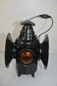
Panhandle and Santa Fe RY Dressel Switch LampJM Hobby Supply and Railroad Artifact Auctions4.4(126)See Sold PriceFeb 24, 2024
EARLY 18TH C. DUTCH CHART OF PACIFIC OCEAN BY FREDERIK DE WIT (1629-1706) WITH CALIFORNIA AS ANThomaston Place Auction Galleries4.4(386)See Sold PriceFeb 24, 2024
Egyptian Faience Amulet with Thoth as Ibis and MaatTimeLine Auctions Ltd.4.5(183)See Sold PriceMar 06, 2024
1919 The Story of The Great War by Official Sources Volumes 1,2,3,8.North American Artifact Auctions4.6(182)See Sold PriceApr 20, 2024
1711 GREEK BIBLE ILLUSTRATED w/ MAPS VELLUM BOUND antique NEW TESTAMENTJasper524.5(9.8k)See Sold PriceFeb 27, 2024
1738 RUSSIA SIBERIA & GREAT TARTARY Description illustrated ANTIQUE in ENGLISHJasper524.5(9.8k)See Sold PriceFeb 27, 2024
Georg Bockler Map of Ancient Jerulsaem EtchingAuctions at Showplace4.5(726)See Sold PriceApr 07, 2024