SoldSmith (Charles) Map Twelve Miles Round LondonSmith (Charles) Map of the Country Twelve Miles Round London,extending from Hadley to Addington, and from Northolt to Hornchurch, engraved folding map, dissected and linen-backed, with originaSee Sold Price
SoldLondon.- Smith (Charles) Map of the Country TwelveLondon.- Smith (Charles) Map of the Country Twelve Miles Round London, showing from Ewell to Enfield, and from Southall to Hornchurch in the east, engraved map by W.R. Gardner, with early hand-colouriSee Sold Price
SoldSmith (Charles) Map of the Country Twelve Miles RoSmith (Charles) Map of the Country Twelve Miles Round London,1st edition, from Enfield to Ewell and from Dartford to Southall, engraved map by W.R. Gardner, with original hand-colouring, 745 xSee Sold Price
Smith (Charles) Map of the Country Twelve Miles RoSmith (Charles) Map of the Country Twelve Miles Round London,1st edition, from Enfield to Ewell and from Dartford to Southall, engraved map by W.R. Gardner, with original hand-colouring, 745 xSee Sold Price
SoldSmith (C., & W.R. Gardner) Map of the Country TwelSmith (C., & W.R. Gardner) Map of the Country Twelve Miles Round London,showing from Enfield Wash through to Banstead Downs and Hornchurch through to Southall, engraved map, with original outlSee Sold Price
SoldJohn Fairburn, London.John Fairburn, London. 'The Travelling Handkerchief' - Fairburn's Map of the Country Twelve Miles Round London, circular map printed on calico, 1831, with vignettes of Chelsea and Greenwich to the lowSee Sold Price
SoldJohn Fairburn, London.John Fairburn, London. 'The Travelling Handkerchief' - Fairburn's Map of the Country Twelve Miles Round London, circular map printed on calico, 1831, with vignettes of Chelsea and Greenwich to the lowSee Sold Price
London.- Gardner (W.R.) Map of the Country Twelve MilesLondon.- Gardner (W.R.) Map of the Country Twelve Miles Round London, engraved map, with outline hand-colouring, 750 x 880 mm. (29 1/2 x 34 3/4 in), dissected and mounted on linen, surface dirt and liSee Sold Price
SoldLondon.- Smith & Sons (Charles) Smith's Indicator MapNO RESERVE London.- Smith & Sons (C.) Smith's Indicator Map of London, showing from Hyde Park to Mile End, including Regents Park and part of Victoria Park with the City of London highlighted in red,See Sold Price
SoldLondon.- Malcolm (James Peller) Views within TwelveLondon.- Malcolm (James Peller) Views within Twelve Miles Round London...as described by Mr. Lysons in his Environs of London, vol.1 [all published], 75 engraved plates, 11 hand-coloured or partly so,See Sold Price
Sold1764 Four Maps Sixteen Miles Round London1764 Four-Map set of "An Accurate Map of the Country Sixteen Miles round London Drawn and Engrav’d from an Actual Survey". The maps represent the four section of the total map and were printed for GSee Sold Price
SoldTravel Poster London Cycling Road Map 50 Miles FoldedOriginal vintage folded map of Bacon's Cycling Road Map - 50 Miles Round London. Publlished by G.W. Bacon & Co. Ltd, 127 Strand, London. George Washington Bacon (1830–1922) was an American mapmSee Sold Price
Sold1775 Map, 100 Miles Round Boston, LondonHand colored copper plate printed map, titled "100 Miles Round Boston", Published 1775, "The Gentleman's Magazine", London. Framed and matted under glass. Measures 9.25"H x 10" W.See Sold Price
London.- Smith (Charles) Reynolds's Map of London withNO RESERVE London.- Smith (Charles, publisher) Reynolds's Map of London with the recent Improvements, lithographed map printed in colours, 605 x 880 mm. (23 3/4 x 34 3/4 in), dissected and mounted onSee Sold Price
SoldLondon.- Cruchley (George Frederick) New Map ExtendingLondon.- Cruchley (George Frederick) New Map Extending 24 Miles Round London, showing all the Mail, Turnpike, and Cross Roads, Gentleman's Seats, parks etc. etc. Also all the Proposed Railways, &c., cSee Sold Price
SoldCruchley (G.F.) 24 Miles Round LondonCruchley (G.F.) New Map Extending 24 Miles Round London...also all the proposed Railways, folding engraved map partly hand-coloured, 690 x 710 mm., worn slip-case, printed label, 1838 § Mogg (See Sold Price
SoldLondon.- Overton (Henry & Hoole, J. ) A New & CorrectLondon.- Overton (Henry) A New & Correct Map of Thirty Miles Round London Shewing all the Towns, Villages Roads &c..., scarce circular map of the enirons of London, showing from Great Marlow in the WeSee Sold Price
SoldSmith (Charles) Smith's New Map of London and StreSmith (Charles) Smith's New Map of London and Street Indicator,from Islington to Kennington Oval, and from Commercial and Surrey Docks to Hyde Park, with indicator tape on original brass mountSee Sold Price
SoldLondon.- Smith & Sons (Charles) Illustrated Map ofLondon.- Smith & Sons (Charles) Illustrated Map of London, map of London from Hyde Park to Islington, and Whitechapel to Vauxhall, with numerous bird's-eye view vignette illustrations showing sites ofSee Sold Price
SoldLondon.- Cruchley (George Frederick) From the OrdnanceLondon.- Cruchley (George Frederick) From the Ordnance Survey of the Country Thirty Miles round London, map of the environs of London showing from Hertford to Godalming and Tunbridge, and from MaidenhSee Sold Price
London.- Cruchley (George Frederick) From the OrdnanceLondon.- Cruchley (George Frederick) From the Ordnance Survey of the Country Thirty Miles round London, map of the environs of London showing from Hertford to Godalming and Tunbridge, and from MaidenhSee Sold Price
SoldTwo Fine British Hand-Colored Engraved MapsTwo Fine British Hand-Colored Engraved Maps including "Twenty-Five Miles Round London", hand-colored engraving by William Faden, published by Scatchard & Co. Avemaria Lane, London, July 14, 1819; andSee Sold Price
SoldA Map of the Countries Thirty Miles Round London.A Map of the Countries Thirty Miles Round London. Drawn & engraved from Accurate Surveys by Tho. Kitchin, Hydrographer to His Majesty Sight: 19 1/2" x 20 1/2" Frame: 24" x 25"See Sold Price
Road map to golf links 30 miles round LondonHeading: Author: Gross, Alexander Title: 30 Miles Round London: Golf Links in Area of 30 Miles Round London Place Published: London Publisher:Geographia Ltd. Date Published: 1913 DescrSee Sold Price
CHARLES KINGSLEY ILLUSTRATIONS BY H.C.SELOUS OF HEREWARD THE WAKE (ART UNION OF LONDON)Luis Porretta Fine Arts4.3(10)See Sold PriceMar 02, 2024
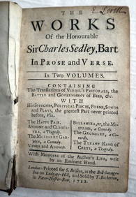
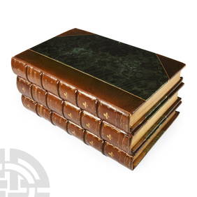
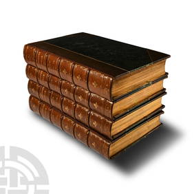
CHARLES SEDLEY BART Works In Prose c1722 1st Edition Full Calf SCARCE!Luis Porretta Fine Arts4.3(10)See Sold PriceMar 02, 2024
Archaeological Books - Roach Smith & Fairholt - The Antiquities of Richborough, Reculver, and Lymne,TimeLine Auctions Ltd.4.6(184)See Sold PriceMar 06, 2024
Archaeological Books - Roach Smith - Collectanea Antiqua, etchings and notices of ancient remains,TimeLine Auctions Ltd.4.6(184)See Sold PriceMar 06, 2024
Archaeological Books - Inventorium Sepulchrale: an Account of Some AntiquitiesTimeLine Auctions Ltd.4.6(184)See Sold PriceMar 06, 2024
Archaeological Books - Roach Smith - Collectanea Antiqua, etchings and notices of ancient remains,TimeLine Auctions Ltd.4.6(184)See Sold PriceMar 06, 2024
Archaeological Books - Roach Smith - Catalogue of the Museum of London AntiquitiesTimeLine Auctions Ltd.4.6(184)See Sold PriceMar 06, 2024
Pair of Single-arm Hurricane Wall Sconces by Charles Edwards of London, EnglandCain Modern Auctions4.4(45)See Sold PriceFeb 28, 2024
Schomburgk - The Comuti or Taquiare (Taquiari) Rock on the River EssequiboTrillium Antique Prints & Rare Books4.5(33)See Sold PriceFeb 24, 2024
Schomburgk - Pirara and Lake Amucu, The Site of El DoradoTrillium Antique Prints & Rare Books4.5(33)See Sold PriceFeb 24, 2024
D'Oyly (Calcutta, India) - Government House from St. Andrew's LibraryTrillium Antique Prints & Rare Books4.5(33)See Sold PriceFeb 24, 2024
D'Oyly (Calcutta, India) - Procession of the CurruckpoojaTrillium Antique Prints & Rare Books4.5(33)See Sold PriceFeb 24, 2024
1764 MAP OF COUNTRIES THIRTY MILES ROUND LONDON antique 12.5 by 15"Jasper524.5(9.9k)See Sold PriceFeb 27, 2024
T. Kelly - Plan of Bruseels - Battle of Waterloo, London - History of the French RevolutionProverde Auctions4.3(3)See Sold PriceFeb 28, 2024