ATLAS of ANTIENT GEOGRAPHY by SAMUEL BUTLER 1843John McInnis Auctioneers,LLC4.6(502)See Sold PriceFeb 24, 2024
18TH C. ANTIQUE MAP: FRENCH & INDIAN WAR, FRAMEDThomaston Place Auction Galleries4.4(386)See Sold PriceFeb 24, 2024
Rand McNally Railroad Map Cabinet w/ 21 Railroad MapsRail & Road Auctions4.6(165)See Sold PriceMar 08, 2024
Keith Haring - Ink on New York Map, Best Buddies, Inscribed, Signed, and DatedSapphire Auction Gallery4(67)See Sold PriceMar 02, 2024
LATE 17TH C. FRENCH MAP OF THE NEW WORLD BY ALEXIS-HUBERT JAILLOT (1632-1712)Thomaston Place Auction Galleries4.4(386)See Sold PriceFeb 24, 2024
Central Railroad of New Jersey Map of Sandy Hook Route-ca. 1903JM Hobby Supply and Railroad Artifact Auctions4.4(126)See Sold PriceFeb 24, 2024
Lot of Six Mixed Atlas Box Cars-HO Scale-New in BoxJM Hobby Supply and Railroad Artifact Auctions4.4(126)See Sold PriceFeb 25, 2024
Rand McNally/Santa Fe Railroad Map of Iowa-1912JM Hobby Supply and Railroad Artifact Auctions4.4(126)See Sold PriceFeb 24, 2024
NICOLAES VISSCHER (NETHERLANDS, 1618-1709) MAP OF THE NEW WORLDThomaston Place Auction Galleries4.4(386)See Sold PriceFeb 24, 2024
17TH C. WORLD MAP BY NICOLAES VISSCHER (NETHERLANDS, 1618-1709)Thomaston Place Auction Galleries4.4(386)See Sold PriceFeb 24, 2024
Lot of Six Mixed Atlas Cabooses-HO Scale-New in BoxJM Hobby Supply and Railroad Artifact Auctions4.4(126)See Sold PriceFeb 25, 2024
SoldA Map of the Countries Thirty Miles Round London.A Map of the Countries Thirty Miles Round London. Drawn & engraved from Accurate Surveys by Tho. Kitchin, Hydrographer to His Majesty Sight: 19 1/2" x 20 1/2" Frame: 24" x 25"See Sold Price
SoldTwo 18th century London maps. Thomas Kitchin, A Map ofTwo 18th century London maps. Thomas Kitchin, A Map of the Countries Thirty Miles Round London, engraving c.1773 with outline colour for Noorthouck's History of London, 53 x 55cm; Carrington Bowles, BSee Sold Price
SoldWilliam Collins Ordnance Survey Map of the CountrWilliam Collins divided coloured engraving, Ordnance Survey Map of the Country Thirty Miles round London, 1841, and three other maps.See Sold Price
Andrews's New and Accurate Map of the Country ThirtyAndrews's New and Accurate Map of the Country Thirty Miles Round London, late Georgian hand coloured folding map with slip case, published and sold by James Heskett 1826 68cm x 65cmSee Sold Price
Andrews (John) Andrews's New and Accurate Map of tAndrews (John) Andrews's New and Accurate Map of the Country Thirty Miles Round London,from Stevenage to East Grinstead, and from Great Marlow to Canvey Island, title panel above, engraved mapSee Sold Price
SoldAndrews (John) Andrews's New and Accurate Map of tAndrews (John) Andrews's New and Accurate Map of the Country Thirty Miles Round London,from Stevenage to East Grinstead, and from Canvey Island to Great Marlow, title panel above, engraved mapSee Sold Price
SoldLondon.- Cruchley (George Frederick) From the OrdnanceLondon.- Cruchley (George Frederick) From the Ordnance Survey of the Country Thirty Miles round London, map of the environs of London showing from Hertford to Godalming and Tunbridge, and from MaidenhSee Sold Price
London.- Cruchley (George Frederick) From the OrdnanceLondon.- Cruchley (George Frederick) From the Ordnance Survey of the Country Thirty Miles round London, map of the environs of London showing from Hertford to Godalming and Tunbridge, and from MaidenhSee Sold Price
SoldLondon.- Froggett (John) Froggett's Survey of theLondon.- Froggett (John) Froggett's Survey of the Country Thirty Miles round London, 1831, from Reigate to Hertford, and Maidenhead to Rochester in the east, engraved map, 1130 x 1370 mm. (44 1/2 x 54See Sold Price
SoldCruchley (G F) Environs of LondonCruchley (G F) [Environs of London] from the Ordnance Survey of the Country Thirty Miles round London, from Hertford to Godalming and Tunbridge, and from Maidenhead to Chatham, showing extensiSee Sold Price
Cruchley (George Frederick) From the Ordnance SurvCruchley (George Frederick) From the Ordnance Survey of the Country Thirty Miles Round London,from Hertford to Tonbridge and Godalming, and from Chatham to Maidenhead, showing the Gravesend toSee Sold Price
Cruchley (George) From the Ordnance Survey of theCruchley (George) From the Ordnance Survey of the Country Thirty Miles round London,from Hertford to Godalming and Tonbridge, and from Maidenhead to Chatham, titled in upper border, with railwSee Sold Price
SoldLondon.- Overton (Henry & Hoole, J. ) A New & CorrectLondon.- Overton (Henry) A New & Correct Map of Thirty Miles Round London Shewing all the Towns, Villages Roads &c..., scarce circular map of the enirons of London, showing from Great Marlow in the WeSee Sold Price
JOHN H. EDDY - MAP OF THE COUNTRY THIRTY MILES ROUNDJohn H. Eddy - Map Of The Country Thirty Miles Round The City Of New York, 1811 - 44 X 43 3/8 In. This is a Giclée on Canvas. Very Large Piece!See Sold Price
JOHN H. EDDY - MAP OF THE COUNTRY THIRTY MILES ROUNDJohn H. Eddy - Map Of The Country Thirty Miles Round The City Of New York, 1811 - 36 X 35 1/2 In. - Giclée Print - Gallery Stretched - Ready to hang.See Sold Price
MAP OF THE COUNTRY THIRTY MILES ROUND THE CITY OF NEWJohn H. Eddy - Map Of The Country Thirty Miles Round The City Of New York, 1811 - 40 X 39 1/2 In. - This Giclée Print Is Gallery Stretched And Ready To HangSee Sold Price
JOHN H. EDDY - MAP OF THE COUNTRY THIRTY MILES ROUNDJohn H. Eddy - Map Of The Country Thirty Miles Round The City Of New York, 1811 - 40 X 39 1/2 In. - This Giclée Print Is Gallery Stretched And Ready To Hang Or Lean Against A Wall, Or Display On An ESee Sold Price
JOHN H. EDDY - MAP OF THE COUNTRY THIRTY MILES ROUNDJohn H. Eddy - Map Of The Country Thirty Miles Round The City Of New York, 1811 - 40 X 39 1/2 In. - This Giclée Print Is Gallery Stretched And Ready To Hang Or Lean Against A Wall, Or Display On An ESee Sold Price
John H. Eddy - Map Of The Country Thirty Miles RoundJohn H. Eddy - Map Of The Country Thirty Miles Round The City Of New York, 1811 Size: 36 X 35 1/2 In. - This Is A Gallery Stretched Giclee Print On Canvas. The Piece Was Printed On High Quality ArtistSee Sold Price
JOHN H. EDDY - MAP OF THE COUNTRY THIRTY MILES ROUNDJohn H. Eddy - Map Of The Country Thirty Miles Round The City Of New York, 1811 - 36 X 35 1/2 In. - Giclée Print - Gallery Stretched - Ready to hang.See Sold Price
JOHN H. EDDY - MAP OF THE COUNTRY THIRTY MILES ROUNDJohn H. Eddy - Map Of The Country Thirty Miles Round The City Of New York, 1811 - 36 X 35 1/2 In. - This Giclée Print Is Gallery Stretched And Ready To Hang Or Lean Against A Wall, Or Display On An ESee Sold Price
JOHN H. EDDY - MAP OF THE COUNTRY THIRTY MILES ROUNDJohn H. Eddy - Map Of The Country Thirty Miles Round The City Of New York, 1811 - 40 X 39 1/2 In. - This Giclée Print Is Gallery Stretched And Ready To Hang Or Lean Against A Wall, Or Display On An ESee Sold Price
JOHN H. EDDY -MAP OF THE COUNTRY THIRTY MILES ROUND THEJohn H. Eddy -map Of The Country Thirty Miles Round The City Of New York, 1811 - Giclée On Canvas -40 X 39 1/2 In. - A Giclée Print Is The Highest Quality Print Available Today. Because There Is NoSee Sold Price
JOHN H. EDDY - MAP OF THE COUNTRY THIRTY MILES ROUNDJohn H. Eddy - Map Of The Country Thirty Miles Round The City Of New York, 1811 - 36 X 35 1/2 In. - This Giclée Print Is Gallery Stretched And Ready To Hang Or Lean Against A Wall, Or Display On An ESee Sold Price
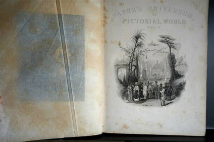
PAYNES UNIVERSUM ca1850 Calf 1st ed Travel 65 X Engravings China etc.Luis Porretta Fine Arts4.3(10)See Sold PriceMar 02, 2024
Archaeological Books - Streeter - Gold: Legal Regulations for the Standard of Gold & Silver Wares inTimeLine Auctions Ltd.4.5(183)See Sold PriceMar 06, 2024
Archaeological Books - Streeter - Gold: Legal Regulations for the Standard of Gold & Silver Wares inTimeLine Auctions Ltd.4.5(183)See Sold PriceMar 06, 2024
5 Dollars - Elizabeth II Map of North AmericaWeatherham Estate Treasures3.9(157)See Sold PriceMar 07, 2024
10 Dollars - Elizabeth II Map of the WorldWeatherham Estate Treasures3.9(157)See Sold PriceMar 07, 2024
ESTATE 14KT YELLOW GOLD DIAMOND & OPAL BEADED NECKLACEAustin Auction Gallery4.7(1.2k)See Sold PriceFeb 25, 2024
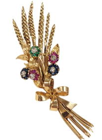
Tiffany & Co. Diamond Ruby Sapphire Emerald En Tremblant 18k Gold Wheat Floral Midcentury BroochHess Fine Auctions4.5(197)See Sold PriceMar 02, 2024
14k White Gold 51.16ct Blue Topaz 2.46ct Diamond NecklaceRiverside Galleries4.5(173)See Sold PriceFeb 26, 2024
Platinum Natural Kunzite and Diamond Ring, Size 7.5Northgate Gallery, Inc.4.5(34)See Sold PriceMar 02, 2024
1764 MAP OF COUNTRIES THIRTY MILES ROUND LONDON antique 12.5 by 15"Jasper524.5(9.8k)See Sold PriceFeb 27, 2024
1800 MUNGO PARK TRAVELS to AFRICA 2 VOLS w/ MAP antique in ENGLISHJasper524.5(9.8k)See Sold PriceFeb 27, 2024
1738 RUSSIA SIBERIA & GREAT TARTARY Description illustrated ANTIQUE in ENGLISHJasper524.5(9.8k)See Sold PriceFeb 27, 2024
NORTH AFRICA. 'Biledulgerid', a former North African country. MALLET 1683 mapJasper524.5(9.8k)See Sold PriceFeb 28, 2024
Stanford, Edward 1901 Large Map. Burma and Adjacent CountriesAlbion Auctions4.6(336)See Sold PriceMar 01, 2024
T. Kelly - Plan of Bruseels - Battle of Waterloo, London - History of the French RevolutionProverde Auctions4.3(3)See Sold PriceFeb 28, 2024
14k White Gold 55.81ct Blue Topaz 2.81ct Diamond NecklaceRiverside Galleries4.5(173)See Sold PriceFeb 27, 2024
Wooden Head Rest Carved in the Shape of a Dog - Ivory CoastKing's Auctions Inc4.2(121)See Sold PriceDec 29, 2024
African Maternity Statue - Breastfeeding - Hand Carved Wood StatueKing's Auctions Inc4.2(121)See Sold PriceDec 29, 2024