ATLAS of ANTIENT GEOGRAPHY by SAMUEL BUTLER 1843John McInnis Auctioneers,LLC4.6(502)See Sold PriceFeb 24, 2024
18TH C. ANTIQUE MAP: FRENCH & INDIAN WAR, FRAMEDThomaston Place Auction Galleries4.4(386)See Sold PriceFeb 24, 2024
Rand McNally Railroad Map Cabinet w/ 21 Railroad MapsRail & Road Auctions4.6(165)See Sold PriceMar 08, 2024
Keith Haring - Ink on New York Map, Best Buddies, Inscribed, Signed, and DatedSapphire Auction Gallery4(67)See Sold PriceMar 02, 2024
LATE 17TH C. FRENCH MAP OF THE NEW WORLD BY ALEXIS-HUBERT JAILLOT (1632-1712)Thomaston Place Auction Galleries4.4(386)See Sold PriceFeb 24, 2024
Central Railroad of New Jersey Map of Sandy Hook Route-ca. 1903JM Hobby Supply and Railroad Artifact Auctions4.4(126)See Sold PriceFeb 24, 2024
Lot of Six Mixed Atlas Box Cars-HO Scale-New in BoxJM Hobby Supply and Railroad Artifact Auctions4.4(126)See Sold PriceFeb 25, 2024
Rand McNally/Santa Fe Railroad Map of Iowa-1912JM Hobby Supply and Railroad Artifact Auctions4.4(126)See Sold PriceFeb 24, 2024
NICOLAES VISSCHER (NETHERLANDS, 1618-1709) MAP OF THE NEW WORLDThomaston Place Auction Galleries4.4(386)See Sold PriceFeb 24, 2024
17TH C. WORLD MAP BY NICOLAES VISSCHER (NETHERLANDS, 1618-1709)Thomaston Place Auction Galleries4.4(386)See Sold PriceFeb 24, 2024
Lot of Six Mixed Atlas Cabooses-HO Scale-New in BoxJM Hobby Supply and Railroad Artifact Auctions4.4(126)See Sold PriceFeb 25, 2024
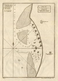
Plan De Portendic Appelle Aussi Portudaddi Ou Penia Tire De LabatTitle: Plan De Portendic Appelle Aussi Portudaddi Ou Penia Tire De Labat Cartographer: BELLIN, JACQUES NICOLAS, ELDER (1703-1772)/LABAT, J. B. (1663-1738) Publisher: DIDOT Height: 8.25 Width: 5.8 FrenSee Sold Price
Plan De Portendic Appelle Aussi Portudaddi Ou PeniaTitle: Plan De Portendic Appelle Aussi Portudaddi Ou Penia Tire De Labat Publication Date: 1747 Cartographer: BELLIN, JACQUES NICOLAS, ELDER (1703-1772)/LABAT, J. B. (1663-1738) Publisher: DIDOT Size:See Sold Price
Plan De Portendic Appelle Aussi Portudaddi Ou PeniaTitle: Plan De Portendic Appelle Aussi Portudaddi Ou Penia Tire De Labat Cartographer: BELLIN, JACQUES NICOLAS, ELDER (1703-1772)/LABAT, J. B. (1663-1738) Publication Date: 1747 Publisher: DIDOT Size:See Sold Price
SoldHome (John) The History of the Rebellion in the YeHome (John) The History of the Rebellion in the Year 1745,map, 3 plans and 1 plate, contemporary half calf, worn, boards detached, T. Cadell Jun., 1802 § Smith (John) England's Improvement RevSee Sold Price
Plan of the City and Castle of Alicant....Isaac Basire, Plan of the City and Castle of Alicant...., engraving, from Paul de Rapin Thoyras, The History of England. Continued by Nicholas Tindall (multiple eds., 1728-1745) See BM Map Cat. I, 331See Sold Price
SoldGUÉLARD Bataille Fontenoy Plan Map MilitariaGUÉLARD - Vue de la Bataille de Fontenoy gagnée par le roy Louis XV sur l'armée des alliez le 11 mai 1745. Paris, Limosin, Plan en noir gravé par Guélard d'après le dessin de Broüard. 340 x 47See Sold Price
SoldPlan of the City of Barcelona, 1745Plan of the City of Barcelona, 1745A vividly colored map depicting the plan of the Spanish city of Barcelona. The city center is laid out, with streets and structures, with imagery for the surroundingSee Sold Price
SoldMap, ''Plan De La Ville de Douay...''Antiquarian map, ''Plan De La Ville de Douay et du Fort D'Escarpe...'', published by Jean Covens & Corneille Mortier, Amsterdam, circa 1745, depicts the fortifications of the town of Douay, sight: 22See Sold Price
SoldMap, ''Plan de Bethune''Antiquarian map, ''Plan de Bethune'', published by Jean Covens & Corneille Mortier, Amsterdam, circa 1745, depicts the fortifications of the town of Bethune, France, sight: 19 1/2''w x 15 1/2''hSee Sold Price
Labat, [Nouveau Voyage aux Isles del'Amerique,] 1722 J. B. Labat, Paris, Rue Jacques, 1722, six volumes, several fold-out plans, maps and black-and-white illustrations including one large fold-out map of Martinique, gilt-decorated periSee Sold Price
SoldThe Holy Bible. Oxford: John Baskett, 1740; The BThe Holy Bible. Oxford: John Baskett, 1740; The Book of Common Prayer. Oxford: Thomas and Robert Baskett, 1745; 4to, 2 engraved titles, engraved plates, 3 folding maps or plans, contemporary red morocSee Sold Price
Covens and Mortier: Antique World Map, 1745Title/Content of Map: 1745 Covens and Mortier World Map -- Mappe-Monde Dressee sur les Observations de Mrs. de l'Academie Royale des Sciences et Quelques Autres et sur les Memoires les Plus Recens DatSee Sold Price
SoldMap, "Plan of New York & Co" 1860, showing ManhattanMap, "Plan of New York & Co" 1860, showing Manhattan (below 45th street), Brooklyn, Williamsburg, Green Point & Jersey City, map is 13.75" by 11.25". Notice: Please note that our auctions will continuSee Sold Price
SoldMap, Plan and Environs, New York, C. 1776The Unversal Magazine plan of the City of New York is among the earliest obtainable maps of New York City.Appearing only 13 years after Bellin's Ville De Manath ou Nouvelle-Yorc, the earliest obtainabSee Sold Price
Tirion: Antique Map Plan of New Orleans, 1765Map: Grondvlakte van Nieuw Orleans, de Hoofstad van Louisiana Cartographer: Tirion Place & Date: Amsterdam / 1765 Size: 10 1/2" x 6 1/2" Condition: b & w; light overall age toning; with folds as issueSee Sold Price
Covens & Mortier: Map of the World Map, 1745Map: 1745 Covens and Mortier World Map -- Mappe-Monde Dressee sur les Observations de Mrs. de l'Academie Royale des Sciences et Quelques Autres et sur les Memoires les Plus Recens Cartographer: CovensSee Sold Price
SoldMap, Plan of New Orleans the capital of Louisiana; withMap, Plan of New Orleans the capital of Louisiana; with the disposition of its quarters and canals as they have been traced by Mr. de la Tour in the year 1720 & The East Mouth of the Mississippi withSee Sold Price
SoldMap, Plan of the Siege of Charleston in South CarolinaMap, Plan of the Siege of Charleston in South Carolinafrom John Marshall's The Life of George Washington (Philadelphia: C. P. Wayne, 1807), depicting the deployment of British forces around the port cSee Sold Price
SDUK: Antique Map of New York City, 1847Title/Content of Map: 'NEW YORK' Antique town city map plan. Manhattan Brooklyn Jersey. Date Printed: 1847 Image Size: Approx 33.0 x 39.0cm, 13 x 15.25 inches (Large) Type: Antique steel engraved mapSee Sold Price
SoldNAPOLEON HIS FOOT ON THE WORLD BRONZE CLOCKAn antique bronze clock with applied gold finish numerals, fancy engraved and scroll cut hands, a brass movement, original patina to the bronze, a battle plan or map draped over the globe, measures 6See Sold Price
SoldMitchell: Antique Plan of Philadelphia, 1870Map: Plan of Philadelphia Cartographer: S. A. Mitchell Place & Date: Philadelphia / 1870 Size: 12 7/8" x 11 1/8" Condition: full color; light overall age toning The marvelously detailed and colored stSee Sold Price
SDUK: Antique City Map of Warsaw, 1847Title/Content of Map: 'WARSAW (WARSZAWA)' antique town city map plan. Building profiles. Colour. Date Printed: 1847 Image Size: Approx 31.5 x 39.5cm, 12.5 x 15.5 inches (Large) Type: Antique steel engSee Sold Price
SDUK: Map of New York City, 1847Title/Content of Map: 'NEW YORK', Antique town city map plan. Manhattan Brooklyn Jersey Date Printed: 1847 Image Size: Approx 33.0 x 39.0cm, 13 x 15.25 inches (Large) Type: Antique steel engraved mapSee Sold Price
SoldBellin: Antique Map of Early Boston, 1757Title/Content of Map: Plan de la Ville de Boston et ses Environs Cartographer: Bellin Place & Date: Paris / 1757/1760 Size: 10 5/8" x 6 3/8" Condition: b&w; light overall age toning; a few spots in thSee Sold Price
COVENS & MORTIER 1745 MAP OF THE GLOBEThomaston Place Auction Galleries4.4(386)See Sold PriceFeb 24, 2024
MAP OF SALZBURG BY GEORGE BRAUN & FRANS HOGENBURG. 1588Thomaston Place Auction Galleries4.4(386)See Sold PriceFeb 24, 2024
DUNLEVIE c1856 Map Counties Of Gaspe & Bonaventure Quebec Canada SCARCE! #2Luis Porretta Fine Arts4.3(10)See Sold PriceMar 02, 2024
DEVINE c1856 Dr Salters Map Of Lake Huron Ontario Indian Lands etc. No. 7 ScarceLuis Porretta Fine Arts4.3(10)See Sold PriceMar 02, 2024
Group of Ten Railroad Photographs, Maps, and Prints - New Jersey, Long Island, and New YorkRail & Road Auctions4.6(165)See Sold PriceMar 07, 2024
1887 Appletons' General Guide to the United State and Canada Part IIRail & Road Auctions4.6(165)See Sold PriceMar 08, 2024
1738 BIBLE in DUTCH ILLUSTRATED w/ MAPS MASSIVE FOLIO in DUTCH antique BIBLIAJasper524.5(9.8k)See Sold PriceFeb 27, 2024
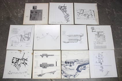
Set of 11 Mid Century Modern Architectural Plans & Site Map RenderingsPUBLIC SALE4.7(217)See Sold PriceMar 02, 2024
West coast of Africa from Cape Blanco… Arguin bay, Mauritania. LABAT 1745 mapJasper524.5(9.8k)See Sold PriceFeb 28, 2024
Plan du Portendic, appellé aussi…' Portendick Mauritania. BELLIN 1746 old mapJasper524.5(9.8k)See Sold PriceFeb 28, 2024
West African fruit. Kola nut. Guava fruit. Kalabash Calabash tree 1745 printJasper524.5(9.8k)See Sold PriceFeb 28, 2024
Plan du Portendic, appellé aussi…' Portendick Mauritania BELLIN/SCHLEY 1747 mapJasper524.5(9.8k)See Sold PriceFeb 28, 2024
Plan de la Baye & Isle d'Arguim'. Mauritania. Arguin island. BELLIN 1746 mapJasper524.5(9.8k)See Sold PriceFeb 28, 2024
Plan of Portendic… Portu d'Addi or Penia. Portendick Mauritania. LABAT 1745 mapJasper524.5(9.8k)See Sold PriceFeb 28, 2024
Western coast of Africa… to the River Sanaga. Southern Mauritania LABAT 1745 mapJasper524.5(9.8k)See Sold PriceFeb 28, 2024
Plan de Fort d'Arguim'. Mauritania. Arguin fort. BELLIN 1746 old antique mapJasper524.5(9.8k)See Sold PriceFeb 28, 2024
Two Hand-Colored 19th Century Maps of New Orleans and Louisiana, Larger- H.- 12 1/2 in., W.- 15 1/2Crescent City Auction Gallery4.3(229)See Sold PriceMar 08, 2024
Vintage Map of Roman Forum - Vatican City - Versailles parkProverde Auctions4.3(3)See Sold PriceFeb 28, 2024