ATLAS of ANTIENT GEOGRAPHY by SAMUEL BUTLER 1843John McInnis Auctioneers,LLC4.6(504)See Sold PriceFeb 24, 2024
18TH C. ANTIQUE MAP: FRENCH & INDIAN WAR, FRAMEDThomaston Place Auction Galleries4.4(389)See Sold PriceFeb 24, 2024
Rand McNally Railroad Map Cabinet w/ 21 Railroad MapsRail & Road Auctions4.6(165)See Sold PriceMar 08, 2024
Keith Haring - Ink on New York Map, Best Buddies, Inscribed, Signed, and DatedSapphire Auction Gallery4.1(67)See Sold PriceMar 02, 2024
LATE 17TH C. FRENCH MAP OF THE NEW WORLD BY ALEXIS-HUBERT JAILLOT (1632-1712)Thomaston Place Auction Galleries4.4(389)See Sold PriceFeb 24, 2024
Central Railroad of New Jersey Map of Sandy Hook Route-ca. 1903JM Hobby Supply and Railroad Artifact Auctions4.4(126)See Sold PriceFeb 24, 2024
Lot of Six Mixed Atlas Box Cars-HO Scale-New in BoxJM Hobby Supply and Railroad Artifact Auctions4.4(126)See Sold PriceFeb 25, 2024
Rand McNally/Santa Fe Railroad Map of Iowa-1912JM Hobby Supply and Railroad Artifact Auctions4.4(126)See Sold PriceFeb 24, 2024
NICOLAES VISSCHER (NETHERLANDS, 1618-1709) MAP OF THE NEW WORLDThomaston Place Auction Galleries4.4(389)See Sold PriceFeb 24, 2024
17TH C. WORLD MAP BY NICOLAES VISSCHER (NETHERLANDS, 1618-1709)Thomaston Place Auction Galleries4.4(389)See Sold PriceFeb 24, 2024
Lot of Six Mixed Atlas Cabooses-HO Scale-New in BoxJM Hobby Supply and Railroad Artifact Auctions4.4(126)See Sold PriceFeb 25, 2024
MAP, Sicily, Italy, BochartiSicily, Italy. Samuelis Bocharti, Sicilia Insula, from Geographiae Sacrae Pars Prior Phaleg..., 1651 (circa). Hand Color. This is a very uncommon map from the work of the Protestant minister and orienSee Sold Price
MAP - Sicily, Italy. BochartiSicily, Italy. Samuelis Bocharti, Sicilia Insula, 1651 (circa). Hand Color. This is a very uncommon map from the work of the Protestant minister and oriental scholar Samuel Bochart (1599-1667). Both tSee Sold Price
SoldMAP, Sicily, Italy, BochartiSicily, Italy. Samuelis Bocharti, Sicilia Insula, 1651 (circa). Hand Color. This is a very uncommon map from the work of the Protestant minister and oriental scholar Samuel Bochart (1599-1667). Both tSee Sold Price
MAP - Sicily, Italy. OrteliusSicily, Italy. Abraham Ortelius, Siciliae Veteris Typus, 1584 (published). Hand Color. Stunning map with three decorative cartouches and a large inset of the harbor and city of Syracuse. Ortelius baseSee Sold Price
SoldMAP, Sicily, Italy, HalmaSicily, Italy. Francois Halma, Sicilien Verdeelt in Zyne Drie Valleyen, 1705 (published). Hand Color. Superb little map of Sicily showing its political divisions and fine detail of topography, cities,See Sold Price
MAP - Sicily, Italy. Mercator/HondiusSicily, Italy. Mercator/Hondius, Sicilia, 1610 (published). Hand Color. Delightful small map of Sicily filled with topographical detail and place names. A smoking Mt. Etna is depicted at right. The maSee Sold Price
MAP - Sicily, Italy. MercatorSicily, Italy. Mercator/Hondius, Siciliae Regnum, 1619 (published). Hand Color. This is a strikingly graphic map of the Kingdom of Sicily, and the first plate to appear in Mercator's Atlas. The map isSee Sold Price
MAP, Sicily, Italy, WitSicily, Italy. Frederick de Wit, Insula sive Regnum Siciliae Urbibus Praecipuis Exornatum, 1680 (circa). Hand Color. This fine and embellished map of Sicily is filled with detail including towns, citiSee Sold Price
MAP - Sicily, Italy. MercatorSicily, Italy. Mercator/Hondius, Siciliae Regnum, 1619 (published). Hand Color. This is a strikingly graphic map of the Kingdom of Sicily, and the first plate to appear in Mercator's Atlas. The map isSee Sold Price
MAP - Sicily, Italy & Malta. Weimar Geo.Sicily, Italy & Malta. Weimar Geographisches Institut, Charte von Sicilien und Malta nach den Bewahrtesten Hulfsmitteln Neu Entworfen und Gezeichnet von F. Goetze, 1801 (dated). Hand Color. The largeSee Sold Price
van Keulen: Antique Nautical Map of Sicily Italy, 1724Large and rare nautical antique chart of Sicily, Italy. 'Nieuwe Afteekening van het Eyland en Koninkryk Sicilia Vertoonende alle desselfs Zee Havenen Anker Plaetsen Riviere Dieptens Klippen Steeden enSee Sold Price
SoldRobert Mylne After Schmettau Map of Sicily ItalyRobert Mylne (1733-1811) after Baron de Schmettau (1684-1751), "The Island and Kingdom of Sicily, According to the best Observations, & Improved," London: Laurie and Whittle, ca. 1810. Hand colored enSee Sold Price
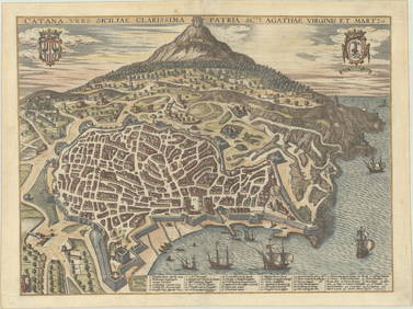
MAP - Palermo, Sicily, Italy. Braun & HogenbergPalermo, Sicily, Italy. Braun & Hogenberg, Palermo, 1620 (circa). Hand Color. This lovely bird's-eye plan shows the important port city of Palermo from the northeast. At the top of the sheet is the PaSee Sold Price
SoldGrp: 7 Maps of Sicily Italy 18th/19th c. Blair ClGroup of seven maps of Sicily. Includes Rev. John Blair, "Sicilia Antiqua quae at Sicania et Trinacria dicta;" Philipp Cluver, "Siciliae Antiquae Descriptio," Leiden, 1697, which features a stunninglySee Sold Price
SoldGrp: 5 Maps of Sicily Italy 18th/19th c. JaillotGroup of five 18th and 19th century maps of Sicily. Includes Hubert Jaillot , "La Sicile divisee en ses trois Provinces ou Valees, scavoir Valle Demona, Valle Di Noto, et Valle Di Mazara;" and GuillauSee Sold Price
SoldRollin, Charles 1780 Map of Syracuse, Sicily ItalyCopper Engraved Map Published 1780, London for "The Ancient History..." by Charles Rollin. Fold as issued. Paper Size: 8.5 x 6 inch (22 x 16cm)See Sold Price
SoldDelamarche, Felix 1829 Map Naples Sicily Sardinia ItalyCopper Engraved Map Published 1829, Paris for "Atlas de La Geographie..." by Felix Delamarche. Contemporary outline hand colour. Centre fold as published. Paper Size: 18.5 x 13 inch (47 x 33cm) SmallSee Sold Price
Antique Hand-colored Harbour Plan - Map Syracuse - Mediterranean, Sicily, ItalyTitle/Artist: Antique Hand-colored Harbour Plan - Map Syracuse - Mediterranean, Sicily, Italy Date: 1804 Material: Paper Dimensions: 17 cm x 23 cm Additional Information: Original hand-colored copperSee Sold Price
Sold18TH CENTURY MAPS OF SICILY & VENICE, ITALYTwo antique hand-colored lithograph maps. The first reads, "Italia Antiqua cum Insulis Sicilia, Sardinia, et Corscia in suas marjores partes et populor divisa, Venetiis, 1785, Apud Antonium Zatta et FSee Sold Price
SoldGrp: 7 Maps of Sicily and Sardinia ItalyGroup of seven maps of Sicily and Sardinia, Italy. Early 18th century Johann Homann (1664-1724) map "Regnorum Sicilia et Sardinia;" 18th century Homann Heirs map of Sicily "Regni & Insulae Siciliae TaSee Sold Price
SoldFenning & Collyer 1765 Map of Naples and Sicily. ItalyCopper Engraved Map Published 1764-65, London for "A New System of Geography: or, A General Description of the World" by Daniel Fenning & Joseph Collyer. Maps by G. Rollos, J. Gibson and others, mostlSee Sold Price
SoldMAP OF ITALY & SICILY, DATED 1820A map of Italy and Sicily, by A. R. Fremin. Dated 1820. Framed. Printed by Dumortier Sculp. Written by Lallemand. Condition noted, staining B/R. Dimensions, 18.5" x 13.75".See Sold Price
SoldFenning & Collyer 1765 Map of Naples and Sicily. ItalyCopper Engraved Map Published 1764-65, London for "A New System of Geography: or, A General Description of the World" by Daniel Fenning & Joseph Collyer. Maps by G. Rollos, J. Gibson and others, mostlSee Sold Price
Map. Southern Italy, Sicily and Sardinia. 1829.Print from steel engraving titled „VIIb. Italia inferior, Sicilia et Sardinia“.From Schul-Atlas der alten Welt. Published by Gotha Perthes. 1829.Orbis Terrarum Antiquus. School Atlas of the AncienSee Sold Price
Light Blue Sunset In Salina Eau De Toilette Spray By Dolce & GabbanaBidhaus4.3(757)See Sold PriceFeb 27, 2024
Cooke, George 1801 Antique Map. Italy, Sicily, Sardinia & CorsicaAlbion Auctions4.6(341)See Sold PriceMar 01, 2024
Blackie (Pub) 1882 Pair of Folio Maps. Italy - North & SouthAlbion Auctions4.6(341)See Sold PriceMar 01, 2024