ATLAS of ANTIENT GEOGRAPHY by SAMUEL BUTLER 1843John McInnis Auctioneers,LLC4.5(505)See Sold PriceFeb 24, 2024
18TH C. ANTIQUE MAP: FRENCH & INDIAN WAR, FRAMEDThomaston Place Auction Galleries4.4(393)See Sold PriceFeb 24, 2024
Rand McNally Railroad Map Cabinet w/ 21 Railroad MapsRail & Road Auctions4.6(165)See Sold PriceMar 08, 2024
Keith Haring - Ink on New York Map, Best Buddies, Inscribed, Signed, and DatedSapphire Auction Gallery4(67)See Sold PriceMar 02, 2024
LATE 17TH C. FRENCH MAP OF THE NEW WORLD BY ALEXIS-HUBERT JAILLOT (1632-1712)Thomaston Place Auction Galleries4.4(393)See Sold PriceFeb 24, 2024
Central Railroad of New Jersey Map of Sandy Hook Route-ca. 1903JM Hobby Supply and Railroad Artifact Auctions4.4(127)See Sold PriceFeb 24, 2024
Lot of Six Mixed Atlas Box Cars-HO Scale-New in BoxJM Hobby Supply and Railroad Artifact Auctions4.4(127)See Sold PriceFeb 25, 2024
Rand McNally/Santa Fe Railroad Map of Iowa-1912JM Hobby Supply and Railroad Artifact Auctions4.4(127)See Sold PriceFeb 24, 2024
NICOLAES VISSCHER (NETHERLANDS, 1618-1709) MAP OF THE NEW WORLDThomaston Place Auction Galleries4.4(393)See Sold PriceFeb 24, 2024
17TH C. WORLD MAP BY NICOLAES VISSCHER (NETHERLANDS, 1618-1709)Thomaston Place Auction Galleries4.4(393)See Sold PriceFeb 24, 2024
Lot of Six Mixed Atlas Cabooses-HO Scale-New in BoxJM Hobby Supply and Railroad Artifact Auctions4.4(127)See Sold PriceFeb 25, 2024
SoldGrp: 5 Maps of Sicily Italy 18th/19th c. JaillotGroup of five 18th and 19th century maps of Sicily. Includes Hubert Jaillot , "La Sicile divisee en ses trois Provinces ou Valees, scavoir Valle Demona, Valle Di Noto, et Valle Di Mazara;" and GuillauSee Sold Price
SoldGrp: 7 Maps of Sicily Italy 18th/19th c. Blair ClGroup of seven maps of Sicily. Includes Rev. John Blair, "Sicilia Antiqua quae at Sicania et Trinacria dicta;" Philipp Cluver, "Siciliae Antiquae Descriptio," Leiden, 1697, which features a stunninglySee Sold Price
SoldGrp: 6 Maps of Italy 18th-19th c.Group of 18th and 19th century maps of Italy. This group includes one map of Italy, Sardinia, Corsica, and Sicily by Carolo Allard; one map of Sicily by Jan Jansson (1588-1664) with an insert detailinSee Sold Price
SoldGrp: 5 Maps of Africa Jaillot DelisleGroup of five maps of Africa. Includes Hubert Jaillot (1632-1712), "L'Afrique divisee suivant l'estendue de ses principales parties, ou sont distingues les uns des autres les Empires, Monarchies, RoyaSee Sold Price
SoldGrp: 7 Maps of Sicily and Sardinia ItalyGroup of seven maps of Sicily and Sardinia, Italy. Early 18th century Johann Homann (1664-1724) map "Regnorum Sicilia et Sardinia;" 18th century Homann Heirs map of Sicily "Regni & Insulae Siciliae TaSee Sold Price
Sold4 maps, 18th-19th C. Italy + ancient geography.[Europe]. 4 engraved maps, hand-colored, double-page. ++ Homann. Novissima & Exactissima Totius Regni Neapolis. Southern Italy, including Naples, c.1740. 21 7/8 x 18 7/8 in. Tape repairs at top of verSee Sold Price
Sold[Greece/Turkey]. 6 Maps On 5 sheets. [18th-19th C[Greece/Turkey]. 6 Maps On 5 sheets. [18th-19th Century]. 15.5 x 14.5 to 18 x 20 inches. Outline/wash color. Includes Stackhouse's Ancient Greece, 1783; Attica and Turkish Dominions In Europe [two mapSee Sold Price
SoldGrp: 5 Maps of Brazil Blaeu Bellin KitchinGroup of five 17th to 19th c. maps of South America and the Caribbean. Thomas Kitchin (1719-1784) map of the Caribbean, "A New Map of the Caribbee Islands in America 1761" London, 1761; Jacques-NicolaSee Sold Price
SoldGrp: 5 Maps of Brazil Blaeu Bellin KitchinGroup of five 17th to 19th c. maps of South America and the Caribbean. Thomas Kitchin (1719-1784) map of the Caribbean, "A New Map of the Caribbee Islands in America 1761" London, 1761; Jacques-NicolaSee Sold Price
SoldCabinet frame — Italy, 18th/19th c.Cabinet frame — Italy, 18th/19th c. Richly profiled plate. Hardwood, blackened. Clear dimensions 46 x 34 cm; external dimensions 68.5 x 56.5 cm. - Probably using old parts.See Sold Price
Moulded Cassetta Frame, Silvered, Italy, 18th/19th C.Wood, silvered Italy, 18th/19th century Ogee sight, plain frieze, moulded hollow, taenia back edge Rebate dimensions: 36.5 x 32.5 cm; total dimensions: 47 x 43 cm Good condition, consistent with age CSee Sold Price
SoldBoetticher, J G A Geographical, Historical, and PoBoetticher (J.G.) A Geographical, Historical, and Political Description of the Empires of Germany, Holland, the Netherlands, Switzerland, Prussia, Italy, Sicily, Corsica and Sardinia,26 maps,See Sold Price
SoldGrp: 2 Maps Sardinia and Sicily Giacomo GastaldiTwo copies of "Tavola Nuova di Sardigna et di Sicilia," from Giacomo (Jacopo) Gastaldi's (ca. 1500-1566) 1548 edition of Ptolemy. Two engraved maps of Sardinia and Sicily, Italy, one hand colored. DimSee Sold Price
Grp: 5 Bronzes 18th/19th Century European BronzesGroup of five 18th and 19th c. European bronzes. Includes one brass crucifix, ca. 1775; one Dutch bronze mourning virgin, ca. 1850-1900; one Roman bronze eagle finial, ca. mid-19th c.; one bronze mermSee Sold Price
SoldVENETIAN NEEDLE LACE YARDAGE, ITALY, 18TH & 19TH C7 pcs: 4 pcs point de plat, WD 5" , total L 185", (few tears at edges); 1 piece rosepoint, 2.5" x 70", (few small stains); 1 pointde neige 2" x 89", (few small tears, few discolorations); 1 rosepoint,See Sold Price
North Italy &C. and the Passes of the Alps & Apennines,Map: North Italy &C. and the Passes of the Alps & Apennines, Publication Date: 1842-02-15 Cartographer: ARROWSMITH, JOHN Publisher: J. ARROWSMITH Size (inches): 19.25X23.5 "by J. Arrowsmith." Shows thSee Sold Price
(4) eglomise matted antique engravings and maps(4) eglomise matted antique engravings and maps, 18th/19th c., gold leaf and faux tortoise matting, larger: 8.5" x 12.5" (sight), smaller: 9.5" x 6.25" (sight), framedSee Sold Price
Profilrahmen — Italien, 18./19. Jh.Profile frame — Italy, 18th/19th c. With engraved rocailles at the corners. Coniferous wood, white painted, partially silver-plated over a red bolus. Clear dimensions 43.5 x 34 cm; external dimSee Sold Price
SoldGrp: 11 Maps of ItalyGroup of eleven maps of Italy. Philipp Cluver map of Italy "Italiae Antiquae Delineatio" W. Poyntell & Co.; Barlow map of "Italy from the Best Authorities" C.Brightly & T.Kinnersley, Suffolk, 1806; JeSee Sold Price
SoldLOT OF (3) VINTAGE 18TH-19TH C. MAPSOverall- 10" x 14 5/8", 12 1/2" x 16". In-house shipping available within U.S. Packing cost- $30See Sold Price
SoldRollin, Charles 1780 Map of Syracuse, Sicily ItalyCopper Engraved Map Published 1780, London for "The Ancient History..." by Charles Rollin. Fold as issued. Paper Size: 8.5 x 6 inch (22 x 16cm)See Sold Price
Sold18th/19th C. Maps and Colored Engravings(4)18th and 19th century maps and colored engravings. Group of four. Measure 13.375 in. - 18.5 in. x 9.625 in. - 11.25 in. F-G/G to G-VG. Unframed, loose and not mounted or glued down. If lot is absent oSee Sold Price
SoldDelamarche, Felix 1829 Map Naples Sicily Sardinia ItalyCopper Engraved Map Published 1829, Paris for "Atlas de La Geographie..." by Felix Delamarche. Contemporary outline hand colour. Centre fold as published. Paper Size: 18.5 x 13 inch (47 x 33cm) SmallSee Sold Price
SoldTwo 18th/19th C. MapsTwo 18th/19th C. maps "Island of Tobago" from actual survey by "Thos Bowen" 1779; "Island of Dominca" by "Thus Bowen" both with French mat and gilt wood frames, both 9.5" x 7.5" sight size.See Sold Price
EARLY 18TH C. MAP OF ITALY, FRAMEDThomaston Place Auction Galleries4.4(393)See Sold PriceFeb 24, 2024
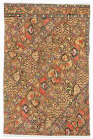
18th/19th C. Ottoman or Continental Mantle and BeltMaterial Culture4.6(778)See Sold PriceFeb 29, 2024
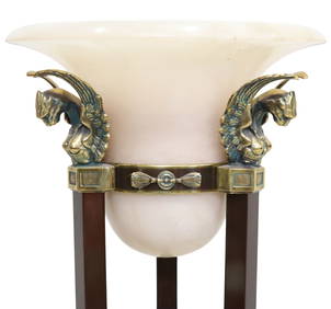
ITALIAN LA RELCO EMPIRE STYLE ALBASTER & GILT METAL TORCHIERE FLOOR LAMPAustin Auction Gallery4.7(1.2k)See Sold PriceFeb 25, 2024
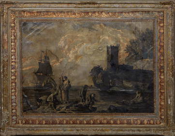
Continental School, "Grisailles Landscape of Figures on the Rocky Shore," 18th/19th c., H.- 36 1/2Crescent City Auction Gallery4.3(231)See Sold PriceMar 09, 2024
Cooke, George 1801 Antique Map. Italy, Sicily, Sardinia & CorsicaAlbion Auctions4.6(341)See Sold PriceMar 01, 2024
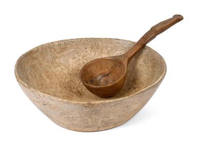
18TH/19TH C. NATIVE AM. ASH BURL BOWL AND LADLE.William Smith Auctions4.6(147)See Sold PriceMar 06, 2024


![[Greece/Turkey]. 6 Maps On 5 sheets. [18th-19th C (1 of 0)](https://p1.liveauctioneers.com/dist/images/placeholder.jpg?height=282&quality=70)