ATLAS of ANTIENT GEOGRAPHY by SAMUEL BUTLER 1843John McInnis Auctioneers,LLC4.6(502)See Sold PriceFeb 24, 2024
18TH C. ANTIQUE MAP: FRENCH & INDIAN WAR, FRAMEDThomaston Place Auction Galleries4.4(386)See Sold PriceFeb 24, 2024
Rand McNally Railroad Map Cabinet w/ 21 Railroad MapsRail & Road Auctions4.6(165)See Sold PriceMar 08, 2024
Keith Haring - Ink on New York Map, Best Buddies, Inscribed, Signed, and DatedSapphire Auction Gallery4(67)See Sold PriceMar 02, 2024
LATE 17TH C. FRENCH MAP OF THE NEW WORLD BY ALEXIS-HUBERT JAILLOT (1632-1712)Thomaston Place Auction Galleries4.4(386)See Sold PriceFeb 24, 2024
Central Railroad of New Jersey Map of Sandy Hook Route-ca. 1903JM Hobby Supply and Railroad Artifact Auctions4.4(126)See Sold PriceFeb 24, 2024
Lot of Six Mixed Atlas Box Cars-HO Scale-New in BoxJM Hobby Supply and Railroad Artifact Auctions4.4(126)See Sold PriceFeb 25, 2024
Rand McNally/Santa Fe Railroad Map of Iowa-1912JM Hobby Supply and Railroad Artifact Auctions4.4(126)See Sold PriceFeb 24, 2024
NICOLAES VISSCHER (NETHERLANDS, 1618-1709) MAP OF THE NEW WORLDThomaston Place Auction Galleries4.4(386)See Sold PriceFeb 24, 2024
17TH C. WORLD MAP BY NICOLAES VISSCHER (NETHERLANDS, 1618-1709)Thomaston Place Auction Galleries4.4(386)See Sold PriceFeb 24, 2024
Lot of Six Mixed Atlas Cabooses-HO Scale-New in BoxJM Hobby Supply and Railroad Artifact Auctions4.4(126)See Sold PriceFeb 25, 2024
SoldRollin, Charles 1780 Map of Syracuse, Sicily ItalyCopper Engraved Map Published 1780, London for "The Ancient History..." by Charles Rollin. Fold as issued. Paper Size: 8.5 x 6 inch (22 x 16cm)See Sold Price
SoldRollin, Charles 1780 Map of Italy"Expedition of Hannibal wherein his Passage into Italy" Copper Engraved Map Published 1780, London for "The Ancient History..." by Charles Rollin. Folds as issued. Paper Size: 20 x 12 inch (50 x 30cm)See Sold Price
SoldRollin, Charles 1780 Map of Old FranceCopper Engraved Map Published 1780, London for "The Ancient History..." by Charles Rollin. Folds as issued. Paper Size: 8.5 x 6 inch (22 x 16cm)See Sold Price
SoldRollin, Charles 1780 Map of Armenia, Holy Land, Caspian"History of the Assyrians, Babylonians, Medes and Persians" Copper Engraved Map Published 1780, London for "The Ancient History..." by Charles Rollin. Folds as issued. Paper Size: 17.5 x 10.5 inch (25See Sold Price
SoldRollin, Charles 1780 Map of The Black Sea/Mediterranean"The Retreat of the Ten Thousand" Copper Engraved Map Published 1780, London for "The Ancient History..." by Charles Rollin. Folds as issued. Paper Size: 12.5 x 10 inch (32 x 26cm) Minor offsetting anSee Sold Price
SoldRollin, Charles 1780 Map of Arabia, Armenia, Black Sea"Alexander's Expedition" Copper Engraved Map Published 1780, London for "The Ancient History..." by Charles Rollin. Folds as issued. Paper Size: 17.5 x 10.5 inch (25 x 22cm) Minor offsetting and toninSee Sold Price
SoldRollin, Charles 1780 Map of The Holy Land"Chart of the Expedition of Cyrus..." Copper Engraved Map Published 1780, London for "The Ancient History..." by Charles Rollin. Folds as issued. Paper Size: 15 x 9.5 inch (38 x 24cm) Several closed tSee Sold Price
SoldRollin, Charles 1780 Map of North Africa"The Carthaginian Empire in Africa" Copper Engraved Map Published 1780, London for "The Ancient History..." by Charles Rollin. Folds as issued. Paper Size: 19 x 9.5 inch (48 x 24cm) Very minor toning.See Sold Price
Rollin, Charles 1780 Map of Old FranceCopper Engraved Map Published 1780, London for "The Ancient History..." by Charles Rollin. Folds as issued. Paper Size: 8.5 x 6 inch (22 x 16cm)See Sold Price
Antique Hand-colored Harbour Plan - Map Syracuse - Mediterranean, Sicily, ItalyTitle/Artist: Antique Hand-colored Harbour Plan - Map Syracuse - Mediterranean, Sicily, Italy Date: 1804 Material: Paper Dimensions: 17 cm x 23 cm Additional Information: Original hand-colored copperSee Sold Price
Zannoni: Antique Map South Italy, Sicily Sardinia 1780Title/Content of Map: 'Sardaigne; Sicile; De Naples; Isle de Malte; Barbarie' A map of southern Italy, Sicily, Sardinia with part of Tunisia Date Printed: c1780 Image Size: Approx 33.5 x 49.0cm, 13.25See Sold Price
SoldMap of ItalyAmsterdam, circa 1704, "Syracuse Antique in Sicilie" by Johannes Blaeu, showing bird's-eye view of Syracuse and surrounding countryside in Sicily, Italy, published by Pierre Mortier, circa 1704, AmsteSee Sold Price
Italy General map including Sicily, Malta, Sardinia,Title/Content of Map: Italy General map including Sicily, Malta, Sardinia, Corsica &c. Date: 1852-01-01 Publisher: S.D.U.K. Charles Knight Size: 15.5Height - 12.25Width Published under the superintendSee Sold Price
MAP - Sicily, Italy. OrteliusSicily, Italy. Abraham Ortelius, Siciliae Veteris Typus, 1584 (published). Hand Color. Stunning map with three decorative cartouches and a large inset of the harbor and city of Syracuse. Ortelius baseSee Sold Price
Italy III.Publication Date: 1852 Title: Italy III. Cartographer: WALKER, J. & C. Publisher: CHARLES KNIGHT/S.D.U.K. Height: 11.3 Width: 15 Map showing southern part of Italy and "Sicily". Shows topography, townSee Sold Price
SoldEarly Italian Map: Syracuse, Italy, 18th CenturySiciliae Antiquae quae et Sicania et Trinacria dicta tabula geographica. Auctore Guillelmo del'Isle e Regia Scientiarum Academia. Amstelodami, apud I. Covens et C. Mortier, Geog. Approximate date:See Sold Price
SoldMAP, Sicily, Italy, HalmaSicily, Italy. Francois Halma, Sicilien Verdeelt in Zyne Drie Valleyen, 1705 (published). Hand Color. Superb little map of Sicily showing its political divisions and fine detail of topography, cities,See Sold Price
MAP, Sicily, Italy, BochartiSicily, Italy. Samuelis Bocharti, Sicilia Insula, from Geographiae Sacrae Pars Prior Phaleg..., 1651 (circa). Hand Color. This is a very uncommon map from the work of the Protestant minister and orienSee Sold Price
MAP - Sicily, Italy. Mercator/HondiusSicily, Italy. Mercator/Hondius, Sicilia, 1610 (published). Hand Color. Delightful small map of Sicily filled with topographical detail and place names. A smoking Mt. Etna is depicted at right. The maSee Sold Price
MAP - Sicily, Italy. MercatorSicily, Italy. Mercator/Hondius, Siciliae Regnum, 1619 (published). Hand Color. This is a strikingly graphic map of the Kingdom of Sicily, and the first plate to appear in Mercator's Atlas. The map isSee Sold Price
MAP, Sicily, Italy, WitSicily, Italy. Frederick de Wit, Insula sive Regnum Siciliae Urbibus Praecipuis Exornatum, 1680 (circa). Hand Color. This fine and embellished map of Sicily is filled with detail including towns, citiSee Sold Price
MAP - Sicily, Italy. BochartiSicily, Italy. Samuelis Bocharti, Sicilia Insula, 1651 (circa). Hand Color. This is a very uncommon map from the work of the Protestant minister and oriental scholar Samuel Bochart (1599-1667). Both tSee Sold Price
MAP - Sicily, Italy. MercatorSicily, Italy. Mercator/Hondius, Siciliae Regnum, 1619 (published). Hand Color. This is a strikingly graphic map of the Kingdom of Sicily, and the first plate to appear in Mercator's Atlas. The map isSee Sold Price
SoldMAP, Sicily, Italy, BochartiSicily, Italy. Samuelis Bocharti, Sicilia Insula, 1651 (circa). Hand Color. This is a very uncommon map from the work of the Protestant minister and oriental scholar Samuel Bochart (1599-1667). Both tSee Sold Price
Lehigh Valley RR 1891 PassJM Hobby Supply and Railroad Artifact Auctions4.4(126)See Sold PriceFeb 24, 2024
C. Rollin, Oeuvres Completes Vol. I-XXXSchmidt's Antiques Inc. Since 19114.8(431)See Sold PriceMar 02, 2024
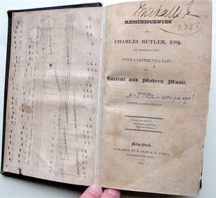
Charles Butler Ancient & Modern Music 1824 1st Edition Scarce MusicLuis Porretta Fine Arts4.3(10)See Sold PriceMar 02, 2024
1885 CIVIL WAR 1ed Famous Memoirs US Grant Sheridan Sherman 6v RARE LOT MapsSchilb Antiquarian Rare Books4.8(421)See Sold PriceMar 10, 2024
EARLY 18TH C. MAP OF ITALY, FRAMEDThomaston Place Auction Galleries4.4(386)See Sold PriceFeb 24, 2024
MAP - PIETER SCHENK / VALK / JANSSEN Hand Colored superb Map Central Italy c1702Luis Porretta Fine Arts4.3(10)See Sold PriceMar 02, 2024
CHARLES ROLLIN c1828 Ceasar Hand Colored Africa Military MapLuis Porretta Fine Arts4.3(10)See Sold PriceMar 02, 2024
Illustrated Sabbath Cloth - Holy Sites of Eretz IsraelLevy Auction House4.3(11)See Sold PriceFeb 27, 2024
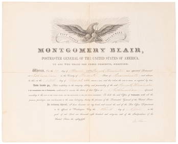
SOMERSET, Lord Charles (1767-1831) and BLAIR, Montgomery (1...Potter & Potter Auctions4.6(539)See Sold PriceMar 07, 2024
Italy & Sicily 1847 Lot of 4 Steel Engravings by PayneAlbion Auctions4.6(336)See Sold PriceMar 07, 2024
Cooke, George 1801 Antique Map. Italy, Sicily, Sardinia & CorsicaAlbion Auctions4.6(336)See Sold PriceMar 01, 2024
Charles Antoine Lemaire (1800 - 1871) - Set of 4 Botanical Prints - Rose - Camellia Duchesse deProverde Auctions4.3(3)See Sold PriceFeb 28, 2024