ATLAS of ANTIENT GEOGRAPHY by SAMUEL BUTLER 1843John McInnis Auctioneers,LLC4.5(505)See Sold PriceFeb 24, 2024
18TH C. ANTIQUE MAP: FRENCH & INDIAN WAR, FRAMEDThomaston Place Auction Galleries4.4(394)See Sold PriceFeb 24, 2024
Rand McNally Railroad Map Cabinet w/ 21 Railroad MapsRail & Road Auctions4.6(165)See Sold PriceMar 08, 2024
Keith Haring - Ink on New York Map, Best Buddies, Inscribed, Signed, and DatedSapphire Auction Gallery4.1(67)See Sold PriceMar 02, 2024
LATE 17TH C. FRENCH MAP OF THE NEW WORLD BY ALEXIS-HUBERT JAILLOT (1632-1712)Thomaston Place Auction Galleries4.4(394)See Sold PriceFeb 24, 2024
Central Railroad of New Jersey Map of Sandy Hook Route-ca. 1903JM Hobby Supply and Railroad Artifact Auctions4.4(127)See Sold PriceFeb 24, 2024
Lot of Six Mixed Atlas Box Cars-HO Scale-New in BoxJM Hobby Supply and Railroad Artifact Auctions4.4(127)See Sold PriceFeb 25, 2024
Rand McNally/Santa Fe Railroad Map of Iowa-1912JM Hobby Supply and Railroad Artifact Auctions4.4(127)See Sold PriceFeb 24, 2024
NICOLAES VISSCHER (NETHERLANDS, 1618-1709) MAP OF THE NEW WORLDThomaston Place Auction Galleries4.4(394)See Sold PriceFeb 24, 2024
17TH C. WORLD MAP BY NICOLAES VISSCHER (NETHERLANDS, 1618-1709)Thomaston Place Auction Galleries4.4(394)See Sold PriceFeb 24, 2024
Lot of Six Mixed Atlas Cabooses-HO Scale-New in BoxJM Hobby Supply and Railroad Artifact Auctions4.4(127)See Sold PriceFeb 25, 2024
Lowry: Map of Scandinavian Kingdoms& Railways, 1863Title/Content of Map: 'Scandinavian Kingdoms Norway, Sweden & Denmark' Railways Date Printed: 1863 Image Size: Approx 43.0 x 31.5cm, 17 x 12.5 inches (Large) Type: Antique map with original outline coSee Sold Price
Scandinavian Kingdoms. Norway, Sweden & Denmark'. Railways. JW LOWRY 1863 mapTITLE/CONTENT OF MAP: 'Europe (General); Inset Density of Population' DATE PRINTED: 1920 IMAGE SIZE: Approx 34.0 x 45.0cm, 13.25 x 17.5 inches (Large) TYPE: Vintage colour map CONDITION: Good; suitablSee Sold Price
Scandinavian Kingdoms. Norway, Sweden & Denmark'. Railways. JW LOWRY 1863 mapTITLE/CONTENT OF MAP: 'Scandinavian Kingdoms Norway, Sweden & Denmark' DATE PRINTED: 1863 IMAGE SIZE: Approx 43.0 x 31.5cm, 17 x 12.5 inches (Large) TYPE: Antique map with original outline colour CONDSee Sold Price
SCANDINAVIA.Shows early railways inc Oslo-Eidsvoll.Norway Sweden.LOWRY 1863 mapTITLE/CONTENT OF MAP: 'Sweden and Norway' The map shows early Scandinavian railway lines, including the first Norwegian railway between Oslo-Eidsvoll which had been completed in 1854. In Sweden it shoSee Sold Price
SCANDINAVIA.Shows early railways inc Oslo-Eidsvoll.Norway Sweden.LOWRY 1863 mapTITLE/CONTENT OF MAP: 'Sweden and Norway' The map shows early Scandinavian railway lines, including the first Norwegian railway between Oslo-Eidsvoll which had been completed in 1854. In Sweden it shoSee Sold Price
EUROPE. Shows Prussia British Ionian Islands Ottoman Empire. LOWRY 1863 mapTITLE/CONTENT OF MAP: 'Europe' The map shows the United States of the Ionian Islands as a separate entity from Greece and Turkey, a state and amical protectorate of the United Kingdom that existed betSee Sold Price
SoldMEDITERRANEAN SEA. Submarine telegraph cables. steamship routes. LOWRY 1863 mapTITLE/CONTENT OF MAP: 'Map of the Mediterranean and Adjacent Countries (on Mercator's Projection) Shewing the Submarine Telegraph Cables, and Lengths of the principal Steam Routes' DATE PRINTED: 1863See Sold Price
SCANDINAVIA.Shows early railways incTITLE/CONTENT OF MAP: 'Sweden and Norway' The map shows early Scandinavian railway lines, including the first Norwegian railway between Oslo-Eidsvoll which had been completed in 1854. In Sweden it shoSee Sold Price
SoldWeller: Antique Map of Great Northern Railway, 1863TITLE/CONTENT OF MAP: 'Great Northern Railway (Sheet 1. London to Grantham & Nottingham)' The route (including all branches shown) runs through the towns of London, Hatfield, Hertford, Stevenage, HitcSee Sold Price
Weller: Antique Map of London & Brighton Railway, 1863TITLE/CONTENT OF MAP: 'London & Brighton Railway' The route (including all branches shown) runs through the towns of London Bridge, Crystal Palace, Croydon, Epsom, Chipstead, Redhill, East Grinstead,See Sold Price
Weller: Antique Map of South Eastern Railway, 1863TITLE/CONTENT OF MAP: 'South Eastern Railway (Dover & Hastings Branches)' The route (including all branches shown) runs through the towns of Tunbridge, Tunbridge Wells, Etchingham, Battle, St Leonard'See Sold Price
Weller: Antique Map of South Coast Railway, 1863Title/Content of Map: 'The South Coast Railway (Portsmouth to Brighton & Hastings.)'. The route (including all branches shown) runs through the towns of Brighton, Lewes, Newhaven, Eastbourne, HailshamSee Sold Price
Weller: Antique Map of London & Brighton Railway, 1863Title/Content of Map: 'London & Brighton Railway'. The route (including all branches shown) runs through the towns of London Bridge, Crystal Palace, Croydon, Epsom, Chipstead, Redhill, East Grinstead,See Sold Price
Weller: Antique Map of North Western Railway, 1863TITLE/CONTENT OF MAP: 'North Western Railway (Sheet 2. Birmingham to Manchester & Liverpool)' The route (including all branches shown) runs through the towns of Manchester, Stockport, Salford, AltrincSee Sold Price
Weller: Antique Map of The South Coast Railway, 1863TITLE/CONTENT OF MAP: 'The South Coast Railway (Portsmouth to Brighton & Hastings.)' The route (including all branches shown) runs through the towns of Brighton, Lewes, Newhaven, Eastbourne, Hailsham,See Sold Price
Lowry: Map of Siberia, Russia in Asia, 1863Title/Content of Map: 'Russia In Asia' Shows Okrugs Oblasts Krais Republics Date Printed: 1863 Image Size: Approx 46.5 x 66.0cm, 18.25 x 26 inches (Large); Please note that this is a folding map. TypeSee Sold Price
A new map of Germany divided into Circles. Austria Switzerland NL Belgium 1811TITLE/CONTENT OF MAP: 'Scandinavian Kingdoms Norway, Sweden & Denmark' DATE PRINTED: 1863 IMAGE SIZE: Approx 43.0 x 31.5cm, 17 x 12.5 inches (Large) TYPE: Antique map with original outline colour CONDSee Sold Price
SoldCORNWALL. Antique county map. Railways. Bodmin Moor.TITLE/CONTENT OF MAP: 'Cornwall; Inset map of Scilly Islands' DATE: 1863 IMAGE SIZE: Approx 32.0 x 43.5cm, 12.75 x 17 inches (Large) TYPE: Antique map with original outline colour CONDITION: Good; suiSee Sold Price
LANCASHIRE. Large antique county map. Railways. WELLER.TITLE/CONTENT OF MAP: 'Lancashire' DATE: 1863 IMAGE SIZE: Approx 65.0 x 46.5cm, 25.5 x 18.25 inches (Large); Please note that this is a folding map. TYPE: Antique map with original outline colour CONDSee Sold Price
KENT. County map. Downs. Railways in use/underTITLE/CONTENT OF MAP: 'Kent' DATE: 1863 IMAGE SIZE: Approx 31.0 x 43.0cm, 12.25 x 16.75 inches (Large) TYPE: Antique map with original outline colour CONDITION: Good; suitable for framing. This map waSee Sold Price
SoldTwo Antique Virginia-Related Works on PaperTwo Antique Virginia-Related Works on Paperto include a pre-1863 map of Virginia and a reproduction print after Day Lowry (VA, 20th Century) illustrating the Virginia War Memorial Carillon, Richmond,See Sold Price
SoldEttling: Antique Map of Upper Canada, 1863TITLE/CONTENT OF MAP: 'Upper Canada' Lakes Huron, Erie & ONTARIO. Counties. Railways. DATE PRINTED: 1863 IMAGE SIZE: Approx 32.0 x 44.5cm, 12.5 x 17.5 inches (Large) TYPE: Antique map with original ouSee Sold Price
SoldWeller: Antique Map of Scotland South East, 1863TITLE/CONTENT OF MAP: 'Scotland (South East sheet)' Borders Central Edinburgh Glasgow Railways. DATE PRINTED: 1863 IMAGE SIZE: Approx 45.0 x 32.5cm, 17.75 x 12.75 inches (Large) TYPE: Antique map withSee Sold Price
SoldStanford (E) Map of Metropolitain RailwaysStanford (Edward) Publisher.- A New Map of Metropolitain Railways & Miscellaneous Improvements Deposited at the Private Bill Office, Nov. 30, 1863, for session 1864,a standard metropolitan mapSee Sold Price
Crawfordsville and Southwestern RY First Mortgage Bond Prospectus Book-1872JM Hobby Supply and Railroad Artifact Auctions4.4(127)See Sold PriceFeb 24, 2024
Crams Colored Railway Map and Shippers Guide of South Dakota 1908-1909JM Hobby Supply and Railroad Artifact Auctions4.4(127)See Sold PriceFeb 24, 2024
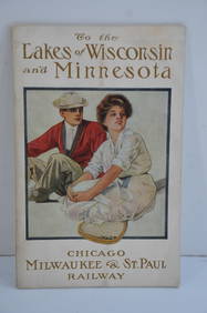
Chicago Milwaukee and St Paul RY To the Lakes of Wisconsin and Minnesota Book-1909JM Hobby Supply and Railroad Artifact Auctions4.4(127)See Sold PriceFeb 24, 2024
Erie Railway Tourist Book/Magazine-1874JM Hobby Supply and Railroad Artifact Auctions4.4(127)See Sold PriceFeb 24, 2024
Great Western RY November 1, 1880 Public TimetableJM Hobby Supply and Railroad Artifact Auctions4.4(127)See Sold PriceFeb 24, 2024
Early 1900's Railway Service Map, Illinois, Ohio, Indiana, Kentucky, TennesseeConnoisseur Auctions3.9(337)See Sold PriceFeb 24, 2024
1855 Map of New York & Erie Railroad and 1917 Trespassing On Railway Property Is A MisdemeanorRail & Road Auctions4.6(165)See Sold PriceMar 07, 2024
Pair of Early Railroad Maps - 1862 Pittsburgh, Ft. Wayne & Chicago Railway and 1873 PennsylvaniaRail & Road Auctions4.6(165)See Sold PriceMar 07, 2024
Group of Ten Railroad Photographs, Maps, and Prints - New Jersey, Long Island, and New YorkRail & Road Auctions4.6(165)See Sold PriceMar 07, 2024
Kansas City Southern Railway Timetable March 1910Rail & Road Auctions4.6(165)See Sold PriceMar 08, 2024
1887 Appletons' General Guide to the United State and Canada Part IIRail & Road Auctions4.6(165)See Sold PriceMar 08, 2024
Rand McNally & Co's New Ideal State and County Survey and Atlas 1911North American Artifact Auctions4.7(201)See Sold PriceApr 20, 2024
Railways & Transport.- [Prospectus] The Dorking, Brighton, and Arundel Atmospheric Railway, byForum Auctions4.4(54)See Sold PriceFeb 29, 2024
SOUTH CENTRAL AFRICA. Shows Zambesi river as circular! WELLER 1863 old mapJasper524.5(9.9k)See Sold PriceFeb 28, 2024
North west Africa. Liberia inset. Sahara Senegambia Guinea. COLTON 1863 mapJasper524.5(9.9k)See Sold PriceFeb 28, 2024
PRE COLONIAL WESTERN AFRICA. Shows Mountains of Kong. Tribes. WELLER 1863 mapJasper524.5(9.9k)See Sold PriceFeb 28, 2024


![Railways & Transport.- [Prospectus] The Dorking, Brighton, and Arundel Atmospheric Railway, by (1 of 1)](https://p1.liveauctioneers.com/5458/319736/171654703_1_x.jpg?height=282&quality=70&version=1708010439)


