ATLAS of ANTIENT GEOGRAPHY by SAMUEL BUTLER 1843John McInnis Auctioneers,LLC4.5(505)See Sold PriceFeb 24, 2024
18TH C. ANTIQUE MAP: FRENCH & INDIAN WAR, FRAMEDThomaston Place Auction Galleries4.4(394)See Sold PriceFeb 24, 2024
Rand McNally Railroad Map Cabinet w/ 21 Railroad MapsRail & Road Auctions4.6(165)See Sold PriceMar 08, 2024
Keith Haring - Ink on New York Map, Best Buddies, Inscribed, Signed, and DatedSapphire Auction Gallery4.1(67)See Sold PriceMar 02, 2024
LATE 17TH C. FRENCH MAP OF THE NEW WORLD BY ALEXIS-HUBERT JAILLOT (1632-1712)Thomaston Place Auction Galleries4.4(394)See Sold PriceFeb 24, 2024
Central Railroad of New Jersey Map of Sandy Hook Route-ca. 1903JM Hobby Supply and Railroad Artifact Auctions4.4(127)See Sold PriceFeb 24, 2024
Lot of Six Mixed Atlas Box Cars-HO Scale-New in BoxJM Hobby Supply and Railroad Artifact Auctions4.4(127)See Sold PriceFeb 25, 2024
Rand McNally/Santa Fe Railroad Map of Iowa-1912JM Hobby Supply and Railroad Artifact Auctions4.4(127)See Sold PriceFeb 24, 2024
NICOLAES VISSCHER (NETHERLANDS, 1618-1709) MAP OF THE NEW WORLDThomaston Place Auction Galleries4.4(394)See Sold PriceFeb 24, 2024
17TH C. WORLD MAP BY NICOLAES VISSCHER (NETHERLANDS, 1618-1709)Thomaston Place Auction Galleries4.4(394)See Sold PriceFeb 24, 2024
Lot of Six Mixed Atlas Cabooses-HO Scale-New in BoxJM Hobby Supply and Railroad Artifact Auctions4.4(127)See Sold PriceFeb 25, 2024
KENT. County map. Downs. Railways in use/underTITLE/CONTENT OF MAP: 'Kent' DATE: 1863 IMAGE SIZE: Approx 31.0 x 43.0cm, 12.25 x 16.75 inches (Large) TYPE: Antique map with original outline colour CONDITION: Good; suitable for framing. This map waSee Sold Price
SoldCruchley's Road and Railway Map... County of Kent[Britain]. Cruchley's Road And Railway Map Of The County Of Kent Showing all the Railways and Names of Stations Also the Turnpike Roads, Villages, Gentlemens Seats &c.&c. Improved from the Ordnance SuSee Sold Price
KentTitle: Kent Cartographer: Walker, J. & C. Publisher: Letts & Son Height: 14.5 Width: 18.5 Handsome little county map with railways in red. Margin bears label imprint: "Sold by Letts & Son, 8 Cornhill.See Sold Price
Crutchley's Road and Railway Map of the County ofGeorge F. Crutchley (1797-1880). Lithograph with original hand color. Edinburgh: Gall & Inglis. 20 x 22 1/2 inches, 29 1/2 x 32 1/4 inches framed. A most attractive and decorative county map of Kent wSee Sold Price
Bacon's Twentieth Century Map of the County of KentTitle: Bacon's Twentieth Century Map of the County of Kent Publication Date: c1902 Cartographer: BACON, G. W. Publisher: G.W. BACON & CO., LTD. Size: 29.25Height - 37.75Width showing railways, roads,See Sold Price
SoldOriginal Travel Poster Kent Fast Frequent TrainsOriginal vintage travel poster issued by the British Railways showing a fun map of Kent - Served by Fast and Frequent Trains. Kent is a county in South East England and one of the home counties. It boSee Sold Price
SoldTwo maps of Delaware, one highlighting New CastleTwo maps of Delaware, one highlighting New Castle County, one highlighting Kent County. Published by A. Finley, Philadelphia. Formerly laid down with glue stains on back. Stains and foxing. Sheet sizeSee Sold Price
Sold"Provincia di Kent". Kent county map. ZATTA 1779 oldTITLE/CONTENT OF MAP: 'Provincia di Kent di nuova projezione' The county of Kent The top image on the right hand side shows the entire map. To view a close up of the map showing the level of printed dSee Sold Price
SoldCORNWALL. Antique county map. Railways. Bodmin Moor.TITLE/CONTENT OF MAP: 'Cornwall; Inset map of Scilly Islands' DATE: 1863 IMAGE SIZE: Approx 32.0 x 43.5cm, 12.75 x 17 inches (Large) TYPE: Antique map with original outline colour CONDITION: Good; suiSee Sold Price
Cumberland antique hand-coloured county map. Railways.TITLE/CONTENT OF MAP: 'Cumberland' Vignette of Carlisle DATE: c1840 IMAGE SIZE: Approx 12.0 x 17.0cm, 4.75 x 6.75 inches (Small); Please note that this is a folding map. TYPE: Antique engraved map. HaSee Sold Price
Moule: Cambridgeshire County Map. Railways, 1840Map: 'Cambridgeshire' Vignettes of Wimpole & Ely Cathedral Date Printed: c1840 Image Size: Approx 12.0 x 17.0cm, 4.75 x 6.75 inches (Small) Type: Antique engraved folding map. Hand colour. Artist/CartSee Sold Price
Provincia di Kent. Kent county map. ZATTA 1779 oldReserve Reduced! TITLE/CONTENT OF MAP: 'Provincia di Kent di nuova projezione' The county of Kent DATE PRINTED: Published in 1779. Engraved in 1779 (this date is printed on the map). IMAGE SIZE: ApproSee Sold Price
LANCASHIRE. Large antique county map. Railways. WELLER.TITLE/CONTENT OF MAP: 'Lancashire' DATE: 1863 IMAGE SIZE: Approx 65.0 x 46.5cm, 25.5 x 18.25 inches (Large); Please note that this is a folding map. TYPE: Antique map with original outline colour CONDSee Sold Price
Cecil & Kent County Map published Atlas of Maryland,Original engraving published by Stedmann & Brown, 1873. Dimensions: 17" x 14 1/2"See Sold Price
SoldBelfast & County Down Railway, an original coat of aBelfast & County Down Railway, an original coat of arms, varnished transfer on painted wood panel, framed and glazed labelled "Presented by the Company" - 53 x 63 cmSee Sold Price
Zatta (Antonio) Provincia di Kent + 2 othersZatta (Antonio) Provincia di Kent,county map with rustic vignette title, lower left, engraved map with original hand-colouring in outline, 200 x 310mm., hinged into mount, Venice, 1779; with BSee Sold Price
Kent.- Harris (John) A Map of the County of KentKent.- Harris (John) A Map of the County of Kent,county map, with border containing 118 coats-of-arms, vignette view of Dover Castle lower right, and with key tables lower left, engraving withSee Sold Price
Morden: Antique Couty Map of Kent, 1772TITLE/CONTENT OF MAP: 'Kent' Kent county map by ROBERT MORDEN from Camden's Britannia Date: 1772 IMAGE SIZE: Approx 37.5 x 65.0cm, 14.75 x 25.5 inches (Large); Please note that this is a folding map.See Sold Price
SoldKent.- Speed (John) Kent, engraved map, [c. 1676].Kent.- Speed (John) Kent, county map with inset maps of Rochester and Canterbury, engraving with original hand-colouring, platemark 380 x 510 mm (15 x 20 in), sheet 420 x 545 mm (16 1/2 x 21 1/2 in),See Sold Price
SoldMorden (Robert) KentMorden (Robert) Kent,county map from Camden's Britannia, with London in upper left corner, large title cartouche lower right, engraved map on two sheets, joined, with hand-colouring in outlineSee Sold Price
SoldKent.- Morden (Robert) Kent, [c. 1695].Kent.- Morden (Robert) Kent, county map, engraving with some outline hand-colouring on laid paper, platemark 360 x 640 mm. (14 1/4 x 25 1/8 in), sheet 415 x 655 mm. (16 1/4 x 25 3/4 in), folds as issuSee Sold Price
SoldBKENT Zatta (Antonio) Provincia di KentBKENT Zatta (Antonio) Provincia di Kent,county map with rustic vignette title, lower left, engraving with original hand-colouring in outline, 200 x 310mm., hinged into mount, Venice, 1779; witSee Sold Price
Morden (Robert) KentMorden (Robert) Kent,county map from Camden's Britannia, with London in upper left corner, large title cartouche lower right, engraved map with hand-colouring, 355 x 630mm., vertical folds, c.See Sold Price
Sold-. Ireland.- Act for Improving Dublin Police-. Ireland.- An Act for Improving the Dublin Police,28pp., 1842; An Act to authorize Loans of Public Money to the Portpatrick and the Belfast and County Down Railway Companies, 7pp., 1865; AnSee Sold Price
Crams Colored Railway Map and Shippers Guide of South Dakota 1908-1909JM Hobby Supply and Railroad Artifact Auctions4.4(127)See Sold PriceFeb 24, 2024
Crams Map of North Dakota-Complete Railroad System and County Map-1907JM Hobby Supply and Railroad Artifact Auctions4.4(127)See Sold PriceFeb 24, 2024
Rand McNally Township County and Railroad Map of Illinois-1879JM Hobby Supply and Railroad Artifact Auctions4.4(127)See Sold PriceFeb 24, 2024
Rand McNally Township County and Railroad Map of Indiana-1880JM Hobby Supply and Railroad Artifact Auctions4.4(127)See Sold PriceFeb 24, 2024
Map UNITED COUNTIES LEEDS & GRENVILLE by Walling 1861 Rare Canada Map 5ft x 5ftLuis Porretta Fine Arts4.3(10)See Sold PriceMar 02, 2024
DUNLEVIE c1856 Map Counties Of Gaspe & Bonaventure Quebec Canada SCARCE! #2Luis Porretta Fine Arts4.3(10)See Sold PriceMar 02, 2024
DUNLEVIE c1856 Map Counties Of Gaspe & Bonaventure Quebec Canada SCARCE! #1Luis Porretta Fine Arts4.3(10)See Sold PriceMar 02, 2024
Archaeological Books - Bowman - Remains of Antiquity Relating to the County of YorkTimeLine Auctions Ltd.4.6(184)See Sold PriceMar 06, 2024
General Books - Nicolson - The Counties of Britain - A Tudor Atlas by John SpeedTimeLine Auctions Ltd.4.6(184)See Sold PriceMar 08, 2024
General Books - Victoria County History of Kent - Vol ITimeLine Auctions Ltd.4.6(184)See Sold PriceMar 08, 2024
Vintage County Map Of NY State Plate EngravingThe Benefit Shop Foundation Inc.4.3(3k)See Sold PriceFeb 28, 2024
Portfolio of 15 County Maps by Robert Morden (English 1650-1703)Nadeau's Auction Gallery4.7(410)See Sold PriceFeb 24, 2024
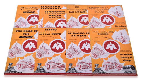
Nine Pieces of CI&L Railway Monon Centennial Show Sheet MusicRail & Road Auctions4.6(165)See Sold PriceMar 07, 2024
1887 Appletons' General Guide to the United State and Canada Part IIRail & Road Auctions4.6(165)See Sold PriceMar 08, 2024
Rand McNally & Co's New Ideal State and County Survey and Atlas 1911North American Artifact Auctions4.7(201)See Sold PriceApr 20, 2024


![Kent.- Speed (John) Kent, engraved map, [c. 1676]. (1 of 1)](https://p1.liveauctioneers.com/5458/268810/140590916_1_x.jpg?height=282&quality=70&version=1668514381)

![Kent.- Morden (Robert) Kent, [c. 1695]. (1 of 1)](https://p1.liveauctioneers.com/5458/156131/78785369_1_x.jpg?height=282&quality=70&version=1574849334)