ATLAS of ANTIENT GEOGRAPHY by SAMUEL BUTLER 1843John McInnis Auctioneers,LLC4.6(504)See Sold PriceFeb 24, 2024
18TH C. ANTIQUE MAP: FRENCH & INDIAN WAR, FRAMEDThomaston Place Auction Galleries4.4(389)See Sold PriceFeb 24, 2024
Rand McNally Railroad Map Cabinet w/ 21 Railroad MapsRail & Road Auctions4.6(165)See Sold PriceMar 08, 2024
Keith Haring - Ink on New York Map, Best Buddies, Inscribed, Signed, and DatedSapphire Auction Gallery4.1(67)See Sold PriceMar 02, 2024
LATE 17TH C. FRENCH MAP OF THE NEW WORLD BY ALEXIS-HUBERT JAILLOT (1632-1712)Thomaston Place Auction Galleries4.4(389)See Sold PriceFeb 24, 2024
Central Railroad of New Jersey Map of Sandy Hook Route-ca. 1903JM Hobby Supply and Railroad Artifact Auctions4.4(126)See Sold PriceFeb 24, 2024
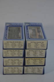
Lot of Six Mixed Atlas Box Cars-HO Scale-New in BoxJM Hobby Supply and Railroad Artifact Auctions4.4(126)See Sold PriceFeb 25, 2024
Rand McNally/Santa Fe Railroad Map of Iowa-1912JM Hobby Supply and Railroad Artifact Auctions4.4(126)See Sold PriceFeb 24, 2024
NICOLAES VISSCHER (NETHERLANDS, 1618-1709) MAP OF THE NEW WORLDThomaston Place Auction Galleries4.4(389)See Sold PriceFeb 24, 2024
17TH C. WORLD MAP BY NICOLAES VISSCHER (NETHERLANDS, 1618-1709)Thomaston Place Auction Galleries4.4(389)See Sold PriceFeb 24, 2024
Lot of Six Mixed Atlas Cabooses-HO Scale-New in BoxJM Hobby Supply and Railroad Artifact Auctions4.4(126)See Sold PriceFeb 25, 2024
Sold[United States]. 4 Maps.[United States]. 4 Maps. ++ Lake Superior And The Northern Part Of Michigan. J. H. Colton: 1855. 11 1/2 x 13 3/4, hand-colored. Corners torn, minor edgewear, map unaffected. ++ Map Of The Central StatSee Sold Price
SoldLake Superior and the Northern Part of Michigan by J.Item: Lake Superior and the Northern Part of Michigan by J. H. Colton Date: 1857 Dimensions: 17.25 x 14 in Please note that this lot has a confidential reserve. When you leave a bid in advance of theSee Sold Price
Sold1855 Colton Map of Lake Superior and the UpperTitle: 1855 Colton Map of Lake Superior and the Upper Peninsula of Michigan-- Lake Superior and the Northern Part of Michigan Cartographer: J Colton Date: 1855, New York Size: 11.8 X 15.5 in. AdditionSee Sold Price
SoldJ. H. Colton, "Lake Superior and the Northern Part ofJ. H. Colton, "Lake Superior and the Northern Part of Michigan, c. 1855, hand colored, H.- 13 5/8 in., W.- 16 7/8 in.See Sold Price
SoldJ. H. COLTON & CO. 2 MAPS, WISCONSIN & SUPERIORJ. H. COLTON & CO. (19TH C.), MAPS, TWO, 15" X 18", WISCONSIN & LAKE SUPERIOR:Likely from Colton's Atlas of the World, including "Lake Superior and the Northern Part of Michigan", No. 43, 14 1/2" x 18See Sold Price
Sold1857 Colton Map of Lake Superior and the Northern PartReserve Reduced! Title/Content of Map: 1857 Colton Map of Lake Superior and the Northern Part of Michigan -- Lake Superior and the Northern Part of Michigan Date: 1857, New York Cartographer: J ColtonSee Sold Price
Sold1855 Colton Map of Lake Superior and the Northern PartTitle: 1855 Colton Map of Lake Superior and the Northern Part of Michigan -- Lake Superior and the Northern Part of Michigan Cartographer: J Colton Year / Place: 1855, New York Map Dimension (in.): 11See Sold Price
1855 Colton Map of Lake Superior and the Northern PartTitle: 1855 Colton Map of Lake Superior and the Northern Part of Michigan -- Lake Superior and the Northern Part of Michigan Cartographer: J Colton Year / Place: 1855, New York Map Dimension (in.): 11See Sold Price
1855 Colton Map of Lake Superior and the Northern PartTitle/Content of Map: 1855 Colton Map of Lake Superior and the Northern Part of Michigan -- Lake Superior and the Northern Part of Michigan Cartographer: J Colton Year/Place: 1855, New York Size: 11.8See Sold Price
1855 Colton Map of Lake Superior and the UpperTitle/Content of Map: 1855 Colton Map of Lake Superior and the Upper Peninsula of Michigan -- Lake Superior and the Northern Part of Michigan Date: 1855, New York Cartographer: J Colton Size: 11.8 X 1See Sold Price
Sold2 Hand Colored Maps - MichiganTwo Gray's Atlas Maps on one sheet - Michigan & Lake Superior and the Northern Part of Michigan Depicts railroad lines, common roads, canals, topography, etc. Maps are on eaSee Sold Price
2 Hand Colored Maps - MichiganTwo Gray's Atlas Maps on one sheet - Michigan & Lake Superior and the Northern Part of Michigan Depicts railroad lines, common roads, canals, topography, etc. Maps aSee Sold Price
2 Hand Colored Maps - MichiganTwo Gray's Atlas Maps on one sheet - Michigan & Lake Superior and the Northern Part of Michigan Depicts railroad lines, common roads, canals, topography, etc. Maps aSee Sold Price
2 Hand Colored Maps - MichiganTwo Gray's Atlas Maps on one sheet - Michigan & Lake Superior and the Northern Part of Michigan Depicts railroad lines, common roads, canals, topography, etc. Maps aSee Sold Price
2 Hand Colored Maps - MichiganTwo Gray's Atlas Maps on one sheet - Michigan & Lake Superior and the Northern Part of Michigan Depicts railroad lines, common roads, canals, topography, etc. Maps aSee Sold Price
2 Hand Colored Maps - MichiganTwo Gray's Atlas Maps on one sheet - Michigan & Lake Superior and the Northern Part of Michigan Depicts railroad lines, common roads, canals, topography, etc. Maps are oSee Sold Price
2 Hand Colored Maps - MichiganTwo Gray's Atlas Maps on one sheet - Michigan & Lake Superior and the Northern Part of Michigan Depicts railroad lines, common roads, canals, topography, etc. Maps aSee Sold Price
2 Hand Colored Maps - MichiganTwo Gray's Atlas Maps on one sheet - Michigan & Lake Superior and the Northern Part of Michigan Depicts railroad lines, common roads, canals, topography, etc. Maps aSee Sold Price
2 Hand Colored Maps - MichiganTwo Gray's Atlas Maps on one sheet - Michigan & Lake Superior and the Northern Part of Michigan Depicts railroad lines, common roads, canals, topography, etc. Maps aSee Sold Price
SoldThree Works on Early Michigan Exploration.[Michigan] Three Works on Early Michigan Exploration. Includes Report on the Geology of the Lake Superior Land District part II by J.W. Foster and J.D. Whitney ([1851] Lacking title page; 33 plates boSee Sold Price
Sold1847 Geological Map of Lake Superior & Michigan"Geological Map of the Lake Superior Land District in the State of Michigan". J. W. Foster and J. D. Whitney, U.S. geologists. Lithographed by J. Ackerman, Broadway, New York. Areas of hand coloring wSee Sold Price
SoldColton: Antique Map of Lake Superior & Michigan, 1859Title/Content of Map: Lake Superior & UP of Michigan by Colton Date Printed: 1859 Cartographer: H. J. Colton Material/Medium: Paper Size: 17 1/2" x 15" Hand colored engraved. Published in New York inSee Sold Price
North America Sheet IV Lake SuperiorTitle: North America Sheet IV Lake Superior Publication Date: 1873 Cartographer: WALKER, J. & C. Publisher: EDWARD STANFORD Size: 11.8 X 15 Map centered on Lake Superior. Shows parts of MN, WI, MI andSee Sold Price
Sold2 Books incl: Stansbury. EXPLORATION... GREAT SALT[Western US]. 2 Titles. ++ J. W. Foster and J. D. Whitney. REPORT ON THE GEOLOGY OF THE LAKE SUPERIOR LAND DISTRICT. Part II. Wash: A. Boyd Hamilton, 1851. 37 plates (incl 2 plates XVIII carrying theSee Sold Price
Frank Serratoni (CA,MI,1908-1970) watercolor paintingBroward Auction Gallery4.8(285)See Sold PriceMar 10, 2024
Frank Serratoni (CA,MI,1908-1970) watercolor paintingBroward Auction Gallery4.8(285)See Sold PriceMar 10, 2024
Frank Serratoni (CA,MI,1908-1970) watercolor paintingBroward Auction Gallery4.8(285)See Sold PriceMar 10, 2024
Frank Serratoni (CA,MI,1908-1970) watercolor paintingBroward Auction Gallery4.8(285)See Sold PriceMar 10, 2024
Lake Superior and Mississippi River RR 1869 Seven Percent Bonds Book/Report-1869JM Hobby Supply and Railroad Artifact Auctions4.4(126)See Sold PriceFeb 24, 2024
Michigan Southern and Northern Indiana RR 14th Annual Report-February 28, 1869JM Hobby Supply and Railroad Artifact Auctions4.4(126)See Sold PriceFeb 24, 2024
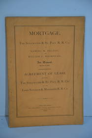
Stillwater and St Paul/Lake Superior and Mississippi RR Mortgage/Lease Agreement-1870JM Hobby Supply and Railroad Artifact Auctions4.4(126)See Sold PriceFeb 24, 2024
Lake Shore and Michigan Southern RR Special Excursions Timetable-July 7-13, 1892JM Hobby Supply and Railroad Artifact Auctions4.4(126)See Sold PriceFeb 24, 2024
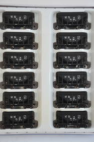
Lake Superior and Ishpeming RR 12-Pack Walthers Ore Cars-HO Scale-New in BoxJM Hobby Supply and Railroad Artifact Auctions4.4(126)See Sold PriceFeb 25, 2024
Eight Car Set-Lake Shore and Michigan Southern RR Work Train-IHC-HO ScaleJM Hobby Supply and Railroad Artifact Auctions4.4(126)See Sold PriceFeb 25, 2024
Lake Superior and Ishpeming RR 12-Pack Walthers Ore Cars-HO Scale-New in BoxJM Hobby Supply and Railroad Artifact Auctions4.4(126)See Sold PriceFeb 25, 2024
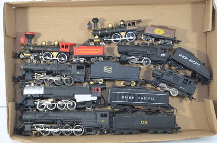
Seven Working Steam Locomotives-LSMS/UP/VT/BM/UP/CO-Unknown/Varney-HO ScaleJM Hobby Supply and Railroad Artifact Auctions4.4(126)See Sold PriceFeb 25, 2024
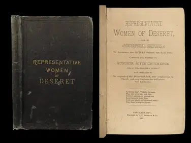
1884 MORMON 1ed Famous Women of LDS Church Deseret Crocheron Eliza Smith Zina YoungSchilb Antiquarian Rare Books4.8(422)See Sold PriceMar 10, 2024
Pere Marquette Railway and Ann Arbor Railroad Ferry PostersRail & Road Auctions4.6(165)See Sold PriceMar 07, 2024
[BOXING]. Press Photo of Joe Louis Training with Freddy Wil...Potter & Potter Auctions4.6(544)See Sold PriceMar 07, 2024
[PHOTOGRAPHS]. 19th – 20th Century Michigan Photo Album lot...Potter & Potter Auctions4.6(544)See Sold PriceMar 07, 2024
Dupont Dulux Marine Finishes Whitmore Lake Michigan Advertising Paint SignHoller and Hammer4.5(57)See Sold PriceFeb 25, 2024
OIL/ CANVAS SGND J.B. BRISTOL "LAKE CHAMPLAIN... FROM LARRABEES POINT, VERMONT (JOHN BUNYON BRISTOLCarlsen Gallery, Inc.4.6(163)See Sold PriceMar 03, 2024
[CANADIANA] CANADIAN CENTERARY SERIES: 18 BOOKSToronto Book Auctions4.3(13)See Sold PriceMar 07, 2024


![[United States]. 4 Maps. (1 of 1)](https://p1.liveauctioneers.com/179/1435/617538_1_x.jpg?height=282&quality=70)


![[BOXING]. Press Photo of Joe Louis Training with Freddy Wil... (1 of 2)](https://p1.liveauctioneers.com/928/318880/171361465_1_x.jpg?height=282&quality=70&version=1707501302)
![[PHOTOGRAPHS]. 19th – 20th Century Michigan Photo Album lot... (1 of 3)](https://p1.liveauctioneers.com/928/318880/171361493_1_x.jpg?height=282&quality=70&version=1707501302)


![[CANADIANA] CANADIAN CENTERARY SERIES: 18 BOOKS (1 of 2)](https://p1.liveauctioneers.com/8321/319996/172038525_1_x.jpg?height=282&quality=70&version=1708462457)

