ATLAS of ANTIENT GEOGRAPHY by SAMUEL BUTLER 1843John McInnis Auctioneers,LLC4.6(502)See Sold PriceFeb 24, 2024
18TH C. ANTIQUE MAP: FRENCH & INDIAN WAR, FRAMEDThomaston Place Auction Galleries4.4(386)See Sold PriceFeb 24, 2024
Rand McNally Railroad Map Cabinet w/ 21 Railroad MapsRail & Road Auctions4.6(165)See Sold PriceMar 08, 2024
Keith Haring - Ink on New York Map, Best Buddies, Inscribed, Signed, and DatedSapphire Auction Gallery4(67)See Sold PriceMar 02, 2024
LATE 17TH C. FRENCH MAP OF THE NEW WORLD BY ALEXIS-HUBERT JAILLOT (1632-1712)Thomaston Place Auction Galleries4.4(386)See Sold PriceFeb 24, 2024
Central Railroad of New Jersey Map of Sandy Hook Route-ca. 1903JM Hobby Supply and Railroad Artifact Auctions4.4(126)See Sold PriceFeb 24, 2024
Lot of Six Mixed Atlas Box Cars-HO Scale-New in BoxJM Hobby Supply and Railroad Artifact Auctions4.4(126)See Sold PriceFeb 25, 2024
Rand McNally/Santa Fe Railroad Map of Iowa-1912JM Hobby Supply and Railroad Artifact Auctions4.4(126)See Sold PriceFeb 24, 2024
NICOLAES VISSCHER (NETHERLANDS, 1618-1709) MAP OF THE NEW WORLDThomaston Place Auction Galleries4.4(386)See Sold PriceFeb 24, 2024
17TH C. WORLD MAP BY NICOLAES VISSCHER (NETHERLANDS, 1618-1709)Thomaston Place Auction Galleries4.4(386)See Sold PriceFeb 24, 2024
Lot of Six Mixed Atlas Cabooses-HO Scale-New in BoxJM Hobby Supply and Railroad Artifact Auctions4.4(126)See Sold PriceFeb 25, 2024
SoldHomann: Antique Map of Belgium Holland Germany FranceTitle: Map of Belgium, Holland, Germany, and France by Homann Date: c 1747 Medium: Hand Colored Copper Plate Engraving Dimensions (in.): 22.5 x 20 No Reserve: This lot starts at $1 and has no reserveSee Sold Price
Antique Map Print - Johann Baptist Homann - Map of Belgium and LuxembourgA beautifully detailed c. 1747 J. B. Homann's map of Belgium and Luxembourg. Depicts Belgium and Luxembourg as well as parts of Holland, France and Germany. The map notes fortified cities, villages, rSee Sold Price
Sold2 maps on silk2 maps on silk including Holland-Belgium-France-Germany; & Zones of France second edition. Stains; Measures 19 1/2 inches x 21 1/2 inches; & 29 inches x 27 1/2 inches.See Sold Price
SoldWWII SILK MAP FRANCE GERMANY BELGIUM HOLLANDWWII SILK MAP FRANCE GERMANY BELGIUM HOLLAND Size: 29'' by 29''See Sold Price
Soldmap, Holland, Belgium, France, GermanyFramed two-sided map of Holland, Belgium, France and Germany, 20th centurySee Sold Price
SoldU.S. WWII silk escape map GERMANY HOLLANDH-158 U.S. WWII silk escape map for "HOLLAND – BELGIUM – FRANCE – GERMANY". Two-sided. 28" x 29 1/2". IISee Sold Price
SoldWWII U.S. MILITARY ISSUE, CLOTH MAP OF EUROPE,WWII U.S. MILITARY ISSUE, CLOTH MAP OF EUROPE, C. 1944, 30" X 30":two sided cloth map of Holland, Belgium, France and Germany, "Sheet C" with "Sheet D" on verso. The map is marked with ink dots of theSee Sold Price
Sold1720 c. Homann Map of Belgium, Northern France andTitle/Content of Map: 1720 c. Homann Map of Belgium, Northern France and Western Germany -- Arena Martis in Belgio, Qua Provinciae X. Catholicae Inferioris Germaniae Cartographer: J Homann Year/Place:See Sold Price
1720 c. Homann Map of Belgium, Northern France andTitle/Content of Map: 1720 c. Homann Map of Belgium, Northern France and Western Germany -- Arena Martis in Belgio, Qua Provinciae X. Catholicae Inferioris Germaniae Cartographer: J Homann Year/Place:See Sold Price
SoldWWII U.S. ARMY SILK MAPSWWII U.S. ARMY SILK MAPS 2 Holland Belgium France and Germany. Water proof pouch maps only LT. Reese.See Sold Price
SoldLot of 2 WWII Air Force silk escape mapsN-031 Lot of 2 WWII Air force silk "escape" maps: (1) British "FRANCE". Reverse "Germany". 23" x 18 1/2". (2) US color map. Holland - BELGIUM - FRANCE (NORTH EAST) - GERMANY (WEST & CENTRAL). ReverseSee Sold Price
Arrowsmith: Antique Map of Germany, Switzerland, 1832TITLE OF MAP: 'Germany, Switzerland, Holland & Belgium' DATE PRINTED: 1832 IMAGE SIZE: Approx 18.0 x 24.5cm, 7 x 9.5 inches (Medium); Please note that this is a folding map. TYPE: Original antique engSee Sold Price
Johnson's France, Holland & Belgium. 2 maps on one sheet 1862 old antiqueTITLE/CONTENT OF MAP: 'Johnson's France // Johnson's Holland and Belgium' DATE PRINTED: 1862 IMAGE SIZE: Approx 42.0 x 64.5cm, 16.5 x 25.25 inches (Large); Please note that this is a folding map. TYPESee Sold Price
Johnson's France, Holland & Belgium. 2 maps on one sheet 1862 old antiqueTITLE/CONTENT OF MAP: 'Johnson's France // Johnson's Holland and Belgium' DATE PRINTED: 1862 IMAGE SIZE: Approx 42.0 x 64.5cm, 16.5 x 25.25 inches (Large); Please note that this is a folding map. TYPESee Sold Price
SoldW. Hughes Map [Germany and Surrounding]W. Hughes (cartographers) map of Central Europe, including Germany, Holland, Belgium, France and Switzerland. Title 'Province of Canada'. Measures 17.5-in. x 24.365-in. sheet size. G+/VG condition, wiSee Sold Price
1846 Map of Central Europe, W. Hughes19th century. A Map of Central Europe embracing Germany, Holland, Belgium, France & Switzerland. Edinburgh. Published by A. & C. Black. Printed in Colours by W. H. McFarlane, Edinburgh. DrawnSee Sold Price
SoldBarclay, James C1835 Lot of 4 Hand Col Europe MapsGermany, Holland/Belgium, France and Spain/Portugal. Hand Colored Steel Engraved Maps Published C1835, London for "A Complete and Universal English Dictionary" by the Rev. James Barclay et al. EngraveSee Sold Price
1730 antique MAP of GERMANY Netherlands Belgium Luxemburg 18th CENTURYNetherlands, Belgium, Luxemburg Tabula generalis totius Belgii qua Provinciae XVII Infer. Germania olim sub S.R.I. Vircula Burgundiae by Homann, Johann Baptist, 1663-1724 Nuremberg, 1730 Size 20.5 bySee Sold Price
1730 antique MAP of GERMANY Netherlands Belgium Luxemburg 18th CENTURYNetherlands, Belgium, Luxemburg Tabula generalis totius Belgii qua Provinciae XVII Infer. Germania olim sub S.R.I. Vircula Burgundiae by Homann, Johann Baptist, 1663-1724 Nuremberg, 1730 Size 20.5 bySee Sold Price
1730 antique MAP of GERMANY Netherlands Belgium Luxemburg 18th CENTURYNetherlands, Belgium, Luxemburg Tabula generalis totius Belgii qua Provinciae XVII Infer. Germania olim sub S.R.I. Vircula Burgundiae by Homann, Johann Baptist, 1663-1724 Nuremberg, 1730 Size 20.5 bySee Sold Price
Central Europe roads canals railways Germany, Holland & Belgium. HUGHES 1862 mapCAPTION PRINTED BELOW PICTURE: 'Map of Central Europe, embracing Germany, Holland, Belgium, with parts of France & Switzerland; showing the roads, canals and railways' DATE PRINTED: 1862 IMAGE SIZE: ASee Sold Price
1730 antique MAP of GERMANY Netherlands Belgium Luxemburg 18th CENTURYNetherlands, Belgium, Luxemburg Tabula generalis totius Belgii qua Provinciae XVII Infer. Germania olim sub S.R.I. Vircula Burgundiae by Homann, Johann Baptist, 1663-1724 Nuremberg, 1730 Size 20.5 bySee Sold Price
Central Europe roads canals railways Germany, Holland & Belgium. HUGHES 1856 mapTITLE/CONTENT OF MAP: 'Map of Central Europe, embracing Germany, Holland, Belgium, with parts of France & Switzerland; showing the roads, canals and railways' DATE PRINTED: 1856 IMAGE SIZE: Approx 43.See Sold Price
1730 antique MAP of GERMANY Netherlands Belgium Luxemburg 18th CENTURYNetherlands, Belgium, Luxemburg Tabula generalis totius Belgii qua Provinciae XVII Infer. Germania olim sub S.R.I. Vircula Burgundiae by Homann, Johann Baptist, 1663-1724 Nuremberg, 1730 Size 20.5 bySee Sold Price
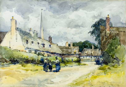
John Muirhead (UK,1863-1927) watercolor painting antiqueBroward Auction Gallery4.8(277)See Sold PriceMar 10, 2024
HEATH'S Picturesque Annual c1833 Germany Belgium Holland Engravings 1st EditionLuis Porretta Fine Arts4.3(10)See Sold PriceMar 02, 2024
17TH C. ANTIQUE MAP SIEGE OF LA ROCHELLE, FRANCE, FRAMEDThomaston Place Auction Galleries4.4(386)See Sold PriceFeb 24, 2024
Large Collection of Various World Currency - CoinsPremier Auction Galleries4.3(329)See Sold PriceMar 09, 2024
D'Entrecasteaux - Map of Australia (New Holland), New Zealand, and southern Asia and surroundingTrillium Antique Prints & Rare Books4.5(30)See Sold PriceFeb 24, 2024
JOSEP MARIA RIERA I ARAGÓ (Barcelona, 1954). Untitled, 1997. Watercolor and ink on paper. SignedSetdart Auction House4.1(22)See Sold PriceMar 05, 2024
Joseph Meyer - Set of 50 Prints - Views of Austria - Germany - Italy - Sweden - France - CzechProverde Auctions4.3(3)See Sold PriceFeb 28, 2024
Joseph Meyer - Set of 50 Prints - Views of Austria - Germany - Italy - Sweden - France - UnitedProverde Auctions4.3(3)See Sold PriceFeb 28, 2024
Joseph Meyer - Set of 20 Prints - Views of Austria - Germany - Italy - Switzerland - France - SpainProverde Auctions4.3(3)See Sold PriceFeb 28, 2024


![W. Hughes Map [Germany and Surrounding] (1 of 2)](https://p1.liveauctioneers.com/5755/147592/74586285_1_x.jpg?height=282&quality=70&version=1565302309)