FRAMED 18TH C. MAP "Karnoviensis", Poland, Silesia,FRAMED 18TH C. MAP "Karnoviensis", Poland, Silesia, Moravia, Johann W. Wieland and M. Schubart, 1736, some separation at fold lines, hand colored, large intricate cartouche, bird's-eye maple frame.See Sold Price
SoldTwo Framed 18th c. Maps Maryland - DelawareTWO framed 18th century maps of Maryland & Delaware 1) Maryland and Delaware together: "J. Denison" c. 1796 at 8" high by 10" wide inside matting.2) "State of Maryland by Samuel Lewis" measuring 11.5"See Sold Price
SoldFRAMED RARE 18TH C. MAP OF CORFU BY HOMANNSPlan de la Place de Corfu avec ses Environs Assiegee Par les Infideles, tranchee ouverte le 25me Juillet jusqu'au 22 me d'Aout, Iour de la Fuite des Ottomans". Homann, J. B. Circa 1740. Hand colored cSee Sold Price
SoldFramed 18th C. French Map of Ancient Rome**First Time At Auction** Louis Brion de la Tour (French, 1743-1810) & Louis Charles Desnos (French, 1725-1805), "Suite De L'Histoire De Rome", ca. 1760 to 1770. Copperplate engraved with original hanSee Sold Price
Sold*FRAMED ANTIQUARIAN 18TH C. MAP"L'ecosse", Great Britain, Ireland and adjacent islands, published by Chez Basset of Paris, 1779, approximate plate size 22" x 19", frame 27" x 22".See Sold Price
Sold2 Framed Tinted 18th c. Maps of Delaware & NJTwo framed 18th century tinted maps of Delaware and New Jersey. Delaware inside the mat measures 7.75" h x 6" w. New Jersey visible image is 10.5" h x 7" w. Both are in very good condition. Frames areSee Sold Price
Sold6 FRAMED ITEMS, TWO 18TH C. MAPS, 12 1/4" X 161/4" OVERALL, WATERCOLOR SIGNED JOAN BRUMLEY, 17" X 21" OVERALL, EARLY ENGRAVING 14 1/4" 19" OVERALL, 2 HUNGARIAN FOLK DRAWERS, 11 1/2" X 14 1/2" OVERALL, BARTOK ESTATESee Sold Price
SoldFramed Antique 18th C R Reynolds Map of AfricaFramed Antique 18th C R Reynolds Map of Africa. Antique 18th century hand colored engraving. With certificate in envelope on back. Measures 13.5 x 16.75 inches.See Sold Price
THREE ANTIQUE 18TH C FRAMED MAPS: SPAIN, ENGLANDLot of three antique 18th century hand colored map engravings. Includes Balearic Islands, Spain, 1778, Antonio Zatta; Buckinghamshire, 1787, J. Cary; and Oxfordshire, 1787, J. Cary. The two smaller EnSee Sold Price
Sold18TH C. FRAMED MAP, ENGLISH CHANNEL "A Correct Chart of18TH C. FRAMED MAP, ENGLISH CHANNEL "A Correct Chart of the English Channel,...from Calais to Brest on the Coast of France", "For Mr. Tindal's Continuation of Mr. Rapin's History", London, 1746, (framSee Sold Price
Sold4 Framed Maps, 18th C., Kitchin & JefferysFour 18th C. Small Framed Maps includes Sweden, Denmark, Norway, Finland, Spain and Portugal by Thomas Kitchin and Thomas Jefferys 7 1/2 x 8 1/2 , framed 16 x 17 1/2 CLAN7190/4 MMSee Sold Price
SoldMap: A framed 18thC hand coloured engraved map ofMap: A framed 18thC hand coloured engraved map of Hampshire by Emanuel Bowen of 'The Road from London to Pool', no. 262, map measures 7 1/4'' x 4 5/8''See Sold Price
Sold18th C. Map of Australia w/Strait of Magellan18th c. framed map of Australia w/the Strait of Magellan. Copper engraved map, hand colored, w/ large colored pictorial cartouche, by Bernaidus Joannis Manasterienfis. Visible paper measures approximaSee Sold Price
SoldTwo 18th C. Framed Asian MapsFrom "A Geography of the World," London 1768. One depicting a map of China, the other depicting a map of Asia. Framed behind glass, 14.5" H x 15.5" W.See Sold Price
Sold18th C. Milan Ducatus Mediterranean Map18th C. framed copper engraved map, hand colored of Milan, Genoa, Lake Como and Mantua Cartouche. By Matthai Serteri, S.C.M. GEOGR Augustani. Visible paper measures approximately 20.25" H X 24" W, witSee Sold Price
SoldJohann Baptiste Homan (1664-1724), "Regnum AngliaJohann Baptiste Homan (1664-1724), "Regnum Angliae," 18th c., colored map, framed, H. 23 in., W.- 19 3/8 in.See Sold Price
SoldGroup Six Framed Maps, 18th/19th CenturyGroup of six framed maps, 18th/19th C., including Chesapeake Bay, Louisiana, West India Isles and others. Framed, not examined out of frames. Sight size: largest 18 1/4" high, 20" wide; smallest: 9" hSee Sold Price
Lot of 18th C. MapsMAP LOT. Lot of three 18th C. British maps. Double framed county maps, "Essex" and "Hereford Shire", published Sept 29, 1741, engraved by W.H. Toms, 6" x 5 3/4" viewed; "Survey of the road from ExeterSee Sold Price
Sold18th C Map of Florence, Hand Colored EngravingFramed 18th century map of Florence, hand colored engraving. Provenance: John's Island, Vero Beach, Florida.See Sold Price
Sold18TH C. MAP OF NORTHEAST U.S. Eglomise framed map of18TH C. MAP OF NORTHEAST U.S. Eglomise framed map of the Northeast United States, "An Account of ye Post of Ye Continent of Nth America as they were Regulated by ye Postmasters Genl of Ye Post House."See Sold Price
Sold18TH C. MAP, SAXONIAEc. 1700, Johanne Baptista Homanno 19 by 22.75 in. (image), matted, framed under glass Prov.: Daphne Farago collectionSee Sold Price
LATE 18TH C. VERY LARGE CHART OF NORTHEAST CANADA BY DES BARRES (1721-1824), 1780, FRAMEDThomaston Place Auction Galleries4.4(393)See Sold PriceFeb 24, 2024
EARLY 18TH C. DUTCH CHART OF PACIFIC OCEAN BY FREDERIK DE WIT (1629-1706) WITH CALIFORNIA AS ANThomaston Place Auction Galleries4.4(393)See Sold PriceFeb 24, 2024
LARGE EARLY 18TH C. DUTCH CHART OF UPPER NORTH AMERICA, PIERRE MORTIER (1661-1711), FRAMEDThomaston Place Auction Galleries4.4(393)See Sold PriceFeb 24, 2024
EARLY 18TH C. MAP OF ITALY, FRAMEDThomaston Place Auction Galleries4.4(393)See Sold PriceFeb 24, 2024
LATE 16TH C. MAP OF SCOTLAND BY MERCATOR, FRAMEDThomaston Place Auction Galleries4.4(393)See Sold PriceFeb 24, 2024
17TH C. MAP OF THE BERKSHIRES BY JOHN SPEED, FRAMEDThomaston Place Auction Galleries4.4(393)See Sold PriceFeb 24, 2024
18TH C. ANTIQUE MAP: FRENCH & INDIAN WAR, FRAMEDThomaston Place Auction Galleries4.4(393)See Sold PriceFeb 24, 2024
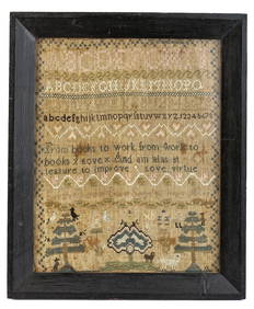
(18th c) SAMPLER by SARAH BROWN born 1780.John McInnis Auctioneers,LLC4.5(505)See Sold PriceFeb 25, 2024
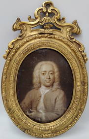
18th c. Cornelis Troost Miniature Portrait of Philips ZweertsHeritage Gallery Auctions4.4(60)See Sold PriceMar 10, 2024
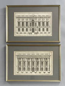
2 Framed 18th C. Parisian Architectural PrintsEpic Auctions and Estate Sales4.6(210)See Sold PriceMar 02, 2024
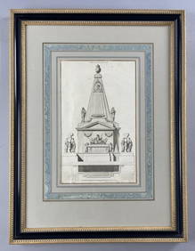
18th C. French Neoclassical Tomb PrintEpic Auctions and Estate Sales4.6(210)See Sold PriceMar 02, 2024
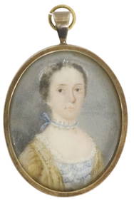
SAMUEL COLLINS (ATTRIB) PORTRAIT MINIATURE, 18TH C.Austin Auction Gallery4.7(1.2k)See Sold PriceFeb 25, 2024
Two (2) Antique 18th C. Copper Engraved Framed Maps - America & EuropeMagnusson Art Group4.5(53)See Sold PriceMar 14, 2024
Map: An 18thC engraved and hand coloured map of Buckinghamshire after Robert Morden. Approx. 8 1/4"Claydon Auctioneers Ltd4.3(125)See Sold PriceFeb 26, 2024
Map: An 18thC engraved and hand coloured map of Northamptonshire, with description ofClaydon Auctioneers Ltd4.3(125)See Sold PriceFeb 26, 2024
Map: An 18thC engraved and hand coloured map of North America and South America, titled DeClaydon Auctioneers Ltd4.3(125)See Sold PriceFeb 26, 2024
Map: An 18thC engraved map of Bedfordshire titled An Accurate Map of the County of Bedford DividedClaydon Auctioneers Ltd4.3(125)See Sold PriceFeb 26, 2024
Map: An 18thC engraved map titled A New and Improved Map of Oxfordshire.. after Thomas Kitchin.Claydon Auctioneers Ltd4.3(125)See Sold PriceFeb 26, 2024