ATLAS of ANTIENT GEOGRAPHY by SAMUEL BUTLER 1843John McInnis Auctioneers,LLC4.5(505)See Sold PriceFeb 24, 2024
18TH C. ANTIQUE MAP: FRENCH & INDIAN WAR, FRAMEDThomaston Place Auction Galleries4.4(393)See Sold PriceFeb 24, 2024
Rand McNally Railroad Map Cabinet w/ 21 Railroad MapsRail & Road Auctions4.6(165)See Sold PriceMar 08, 2024
Keith Haring - Ink on New York Map, Best Buddies, Inscribed, Signed, and DatedSapphire Auction Gallery4.1(67)See Sold PriceMar 02, 2024
LATE 17TH C. FRENCH MAP OF THE NEW WORLD BY ALEXIS-HUBERT JAILLOT (1632-1712)Thomaston Place Auction Galleries4.4(393)See Sold PriceFeb 24, 2024
Central Railroad of New Jersey Map of Sandy Hook Route-ca. 1903JM Hobby Supply and Railroad Artifact Auctions4.4(127)See Sold PriceFeb 24, 2024
Lot of Six Mixed Atlas Box Cars-HO Scale-New in BoxJM Hobby Supply and Railroad Artifact Auctions4.4(127)See Sold PriceFeb 25, 2024
Rand McNally/Santa Fe Railroad Map of Iowa-1912JM Hobby Supply and Railroad Artifact Auctions4.4(127)See Sold PriceFeb 24, 2024
NICOLAES VISSCHER (NETHERLANDS, 1618-1709) MAP OF THE NEW WORLDThomaston Place Auction Galleries4.4(393)See Sold PriceFeb 24, 2024
17TH C. WORLD MAP BY NICOLAES VISSCHER (NETHERLANDS, 1618-1709)Thomaston Place Auction Galleries4.4(393)See Sold PriceFeb 24, 2024
Lot of Six Mixed Atlas Cabooses-HO Scale-New in BoxJM Hobby Supply and Railroad Artifact Auctions4.4(127)See Sold PriceFeb 25, 2024
Sold18TH C. FRAMED MAP, ENGLISH CHANNEL "A Correct Chart of18TH C. FRAMED MAP, ENGLISH CHANNEL "A Correct Chart of the English Channel,...from Calais to Brest on the Coast of France", "For Mr. Tindal's Continuation of Mr. Rapin's History", London, 1746, (framSee Sold Price
Collins: Antique Sea Chart Map of English Channel, 1774Title/Content of Map: 'A new and correct chart of the Channel between England and France with considerable improvements not extant in any draughts hitherto publish'd shewing the sands, shoals, depthsSee Sold Price
Collins: Antique Map of the English Channel, 1774TITLE/CONTENT OF MAP: 'A new and correct chart of the Channel between England and France with considerable improvements not extant in any draughts hitherto publish'd shewing the sands, shoals, depthsSee Sold Price
SoldEnglish Channel.- Mount (Richard) & Thomas Page. A newEnglish Channel.- Mount (Richard) & Thomas Page. A New and Correct Chart of the Channel between England & France with Considerable Improvements, large sea chart of the English Channel, inset maps of PSee Sold Price
SoldMount & Page Chart of the English ChannelMount (William) & Thomas Page A New and Correct Chart of the Channel between England & France, large engraved chart of the English Channel, inset maps of Plymouth Sound and the Isle of Wight,See Sold Price
(5) EARLY FRAMED BRITISH MAPS & COAT OF ARMS(lot of 5) Framed English color maps, originally in a bound book, likely 18th c., showing the coat of arms and regions of Rippon, Scarborough, Pontefract, the Bishoprick of Durham and Stamford, set inSee Sold Price
SoldRollinson: Correct Chart of the English Channel, 1796Map: A Correct Chart of the English Channel Publication Date: 1796-09-01 Maker: SPOTSWOOD AND NANCREDE, ROLLINSON. Publisher: SPOTSWOOD AND NANCREDE Size: Octavo – 7.10 H x 7.25 W Inches Malham's ChSee Sold Price
SoldBritish Isles.- The Channel.- Searle (Richard William)British Isles.- The Channel.- Searle (Richard William) A correct Chart of the English Channel from the No.Foreland to [...] Brest on the coast of France, sea chart of the Channel with four inset mapsSee Sold Price
SoldBritish Isles.- The Channel.- Searle (Richard William)British Isles.- The Channel.- Searle (Richard William) A correct Chart of the English Channel from the No.Foreland to [...] Brest on the coast of France, sea chart of the Channel with four inset mapsSee Sold Price
Sold(4) SMALL FRAMED 18TH C. BRITISH ROYAL NAVY PRINTSOriginal Copperplate Engravings on Oaktag, captioned: "Several of his Majesty's Ships Cruising on the Channel"; "Engagement between an English and a French Man of War"; "A First Rate Ship Hoisting theSee Sold Price
Bowles & Carver - Coloured engraving - "Bowles NewBowles & Carver - Coloured engraving - "Bowles New Topographical Chart of the English Channel with Its Environs", 19.5ins x 27.5ins, and two further maps, all framed and glazedSee Sold Price
Sold18thc Map of Asia, John Senex, EnglandFramed English hand-colored engraved map by John Senex "A New Map of Asia" TITLE: A New Map of Asia from the latest Observations Most Humbly Inscrib'd to the Right Honbl. George Earl of Warrington & cSee Sold Price
SoldMap of St. George's Channel and theIrish Sea, 18th century British, 18th century. R.W. Seale (1732-1785), printed in 1745, "The Correct Chart of the St. George's Channel and the Irish Sea," including all the coast of Ireland and West CSee Sold Price
SoldEnglish 18th C. Petit Point Map of England & WalesDated May 8th 1787 or 1788. Framed and under glass. Sight: 21 x 18. Frame: 25 1/4 x 22 1/2 inches. Shipping weight: 5 lbs.See Sold Price
Chart of the Entrances to the River ThamesChart of the Entrances to the River Thames. William Heather (18th cent.). Engraved map. London, c. 1791. 25 1/4 x 32 3/4 inches sheet. Numerous soundings and depictions of the well-knows sandbanks neaSee Sold Price
Sold18TH C. ENGLISH MINIATURE TERRESTRIAL POCKET GLOBEA Correct GLOBE with the new Discoveries terrestrial glob; the interior of the case lined wSee Sold Price
SoldFRAMED ENGRAVING 'THE DISTREST POET' AFTER HOGARTHFramed engraving, "The Distrest Poet", third state engraving after William Hogarth (English 1697-1764), possibly late 18th c., with "Gold Mines of Peru" map seen above man's head, plate: 12.25"h, 15"wSee Sold Price
SoldMAP OF THE CARIBBEAN 18th CenturyMAP OF THE CARIBBEAN 18th Century Titled "A Correct Chart of the Caribee Islands Sold by Mount & Page London". 17.25" x 21.25" sight. Framed 19" x 23".See Sold Price
Sold18TH C. MAPS OF PHILADELPHIA & BOSTONMap of Philadelphia and parts adjacent, by N. Scull and G. Heap and Boston town plan and harbor chart; Hand-colored engravings (framed separately); Each: 12" x 14"See Sold Price
Sold18th C. FRAMED ENGLISH INDENTURE DATED 1707. SIGNATURE18th C. FRAMED ENGLISH INDENTURE DATED 1707. SIGNATURE AND SEALS AT THE BOTTOM. FRAMED UNDER GLASS. GOOD. 21" H X 29" W.See Sold Price
THREE ANTIQUE 18TH C FRAMED MAPS: SPAIN, ENGLANDLot of three antique 18th century hand colored map engravings. Includes Balearic Islands, Spain, 1778, Antonio Zatta; Buckinghamshire, 1787, J. Cary; and Oxfordshire, 1787, J. Cary. The two smaller EnSee Sold Price
SoldLate 18th c. framed English engravingLate 18th century framed English engraving, titled 'Et Salvatus Est Sanguis Innoxius In Die Illa,' depicting a crowd surrounding a man with bound hands, mounted and framed, sight of sheet 20"h x 26"w,See Sold Price
18th C English Chart ofPublished 12 May 1794 by Laurie WhittleA New Chart of the Coast of Spain and Portugal from Cape Penas to the Streights of Gibraltar29in x 60inSee Sold Price
Sold18th C. Map of Australia w/Strait of Magellan18th c. framed map of Australia w/the Strait of Magellan. Copper engraved map, hand colored, w/ large colored pictorial cartouche, by Bernaidus Joannis Manasterienfis. Visible paper measures approximaSee Sold Price
LATE 18TH C. VERY LARGE CHART OF NORTHEAST CANADA BY DES BARRES (1721-1824), 1780, FRAMEDThomaston Place Auction Galleries4.4(393)See Sold PriceFeb 24, 2024
EARLY 18TH C. DUTCH CHART OF PACIFIC OCEAN BY FREDERIK DE WIT (1629-1706) WITH CALIFORNIA AS ANThomaston Place Auction Galleries4.4(393)See Sold PriceFeb 24, 2024
LARGE EARLY 18TH C. DUTCH CHART OF UPPER NORTH AMERICA, PIERRE MORTIER (1661-1711), FRAMEDThomaston Place Auction Galleries4.4(393)See Sold PriceFeb 24, 2024
17TH C. ENGLISH CHART OF THE THAMES BY CAPT. GREENVILLE COLLINS, 1693-4, FRAMEDThomaston Place Auction Galleries4.4(393)See Sold PriceFeb 24, 2024
EARLY 18TH C. MAP OF ITALY, FRAMEDThomaston Place Auction Galleries4.4(393)See Sold PriceFeb 24, 2024
18TH C. ANTIQUE MAP: FRENCH & INDIAN WAR, FRAMEDThomaston Place Auction Galleries4.4(393)See Sold PriceFeb 24, 2024
17TH C. ENGLISH LINEAR MAP BY OGILBY, FRAMEDThomaston Place Auction Galleries4.4(393)See Sold PriceFeb 24, 2024
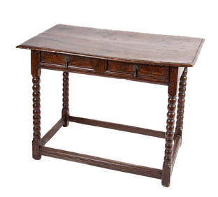
(18th c) ENGLISH BOOK-MATCHED CHEST OF DRAWERSJohn McInnis Auctioneers,LLC4.5(505)See Sold PriceFeb 24, 2024
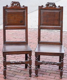
PAIR OF (18th c) ENGLISH OAK SIDE CHAIRSJohn McInnis Auctioneers,LLC4.5(505)See Sold PriceFeb 24, 2024
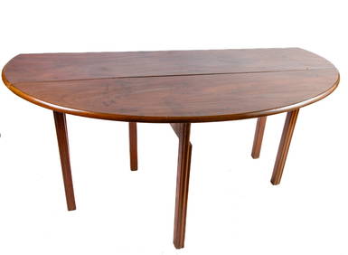
(18th c) ENGLISH CHIPPENDALE DROPLEAF DINING TABLEJohn McInnis Auctioneers,LLC4.5(505)See Sold PriceFeb 25, 2024
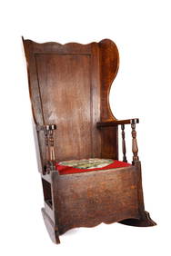
(18th c) ENGLISH JOINED OAK JACOBEAN ROCKING CHAIRJohn McInnis Auctioneers,LLC4.5(505)See Sold PriceFeb 25, 2024
SAMUEL COLLINS (ATTRIB) PORTRAIT MINIATURE, 18TH C.Austin Auction Gallery4.7(1.2k)See Sold PriceFeb 25, 2024
Two (2) Antique 18th C. Copper Engraved Framed Maps - America & EuropeMagnusson Art Group4.5(53)See Sold PriceMar 14, 2024
ANTIQUE 18TH C ENGLISH MALE PORTRAIT OIL PAINTINGAntique Arena Inc.4.5(878)See Sold PriceMar 02, 2024
THE WHOLE CHRONICLE OF POLYBIUS ANCIENT IN ENGLISH, 1756NY Elizabeth 4.2(86)See Sold PriceMar 03, 2024
ANTIQUE 18TH C FEMALE PORTRAIT WATERCOLOR PAINTINGAntique Arena Inc.4.5(878)See Sold PriceMar 09, 2024