ATLAS of ANTIENT GEOGRAPHY by SAMUEL BUTLER 1843John McInnis Auctioneers,LLC4.5(505)See Sold PriceFeb 24, 2024
18TH C. ANTIQUE MAP: FRENCH & INDIAN WAR, FRAMEDThomaston Place Auction Galleries4.4(393)See Sold PriceFeb 24, 2024
Rand McNally Railroad Map Cabinet w/ 21 Railroad MapsRail & Road Auctions4.6(165)See Sold PriceMar 08, 2024
Keith Haring - Ink on New York Map, Best Buddies, Inscribed, Signed, and DatedSapphire Auction Gallery4(67)See Sold PriceMar 02, 2024
LATE 17TH C. FRENCH MAP OF THE NEW WORLD BY ALEXIS-HUBERT JAILLOT (1632-1712)Thomaston Place Auction Galleries4.4(393)See Sold PriceFeb 24, 2024
Central Railroad of New Jersey Map of Sandy Hook Route-ca. 1903JM Hobby Supply and Railroad Artifact Auctions4.4(127)See Sold PriceFeb 24, 2024
Lot of Six Mixed Atlas Box Cars-HO Scale-New in BoxJM Hobby Supply and Railroad Artifact Auctions4.4(127)See Sold PriceFeb 25, 2024
Rand McNally/Santa Fe Railroad Map of Iowa-1912JM Hobby Supply and Railroad Artifact Auctions4.4(127)See Sold PriceFeb 24, 2024
NICOLAES VISSCHER (NETHERLANDS, 1618-1709) MAP OF THE NEW WORLDThomaston Place Auction Galleries4.4(393)See Sold PriceFeb 24, 2024
17TH C. WORLD MAP BY NICOLAES VISSCHER (NETHERLANDS, 1618-1709)Thomaston Place Auction Galleries4.4(393)See Sold PriceFeb 24, 2024
Lot of Six Mixed Atlas Cabooses-HO Scale-New in BoxJM Hobby Supply and Railroad Artifact Auctions4.4(127)See Sold PriceFeb 25, 2024
Sold4 Framed Maps, 18th C., Kitchin & JefferysFour 18th C. Small Framed Maps includes Sweden, Denmark, Norway, Finland, Spain and Portugal by Thomas Kitchin and Thomas Jefferys 7 1/2 x 8 1/2 , framed 16 x 17 1/2 CLAN7190/4 MMSee Sold Price
SoldGroup Six Framed Maps, 18th/19th CenturyGroup of six framed maps, 18th/19th C., including Chesapeake Bay, Louisiana, West India Isles and others. Framed, not examined out of frames. Sight size: largest 18 1/4" high, 20" wide; smallest: 9" hSee Sold Price
SoldThree Antique New Orleans MapsThree Antique New Orleans Maps, 18th c., incl. 2 from Bellin's Petit Atlas Maritime and one published by London Magazine, sights 7 1/2 in. x 9 in. to 8 1/2 in. x 11 3/4 in., framed alikeSee Sold Price
Sold(4) Framed Antiques Prints(2) Depicting the Boston State and Custom House and (2) (18th c.) Maps of England. 6 x 8 inches and smaller Condition: GoodSee Sold Price
Sold18th c Map Turkey & RussiaEighteenth century map of Turkey & Russia, sight size 18-1/4" x 18-1/4", matted and framed. Overall size 27" x 25-3/4".Not examined out of frame. Provenance Pulitzer familySee Sold Price
SoldMap: A framed 18thC hand coloured engraved map ofMap: A framed 18thC hand coloured engraved map of Hampshire by Emanuel Bowen of 'The Road from London to Pool', no. 262, map measures 7 1/4'' x 4 5/8''See Sold Price
Sold18th C. War Map, Waterway Titled "Scaldis Flu".Early 18th Century War Map with Waterway Titled "Scaldis Flu". Image size 9-1/4" x 12", framed and matted, 16" x 19 overall. Along with another unframed map with banner "TERRAE SANCT AE TABVLA", 7-1/2See Sold Price
Sold18th C. Map "Coila Provencia Province of Kyle"18th Century map "Coila Provencia Province of Kyle", 18 7/8" X 23 2/8" , framed 28 3/4" X 33 1/4". Good condition.See Sold Price
Sold18th c. French MapFramed 18th c. steel engraved & colored 18 1/4" x 23 3/4" "A New Map of France" by John Senex, 19 1/2" x 25 1/4" overall size framed.See Sold Price
Lot of 18th C. MapsMAP LOT. Lot of three 18th C. British maps. Double framed county maps, "Essex" and "Hereford Shire", published Sept 29, 1741, engraved by W.H. Toms, 6" x 5 3/4" viewed; "Survey of the road from ExeterSee Sold Price
Sold6 FRAMED ITEMS, TWO 18TH C. MAPS, 12 1/4" X 161/4" OVERALL, WATERCOLOR SIGNED JOAN BRUMLEY, 17" X 21" OVERALL, EARLY ENGRAVING 14 1/4" 19" OVERALL, 2 HUNGARIAN FOLK DRAWERS, 11 1/2" X 14 1/2" OVERALL, BARTOK ESTATESee Sold Price
Ancona/ Ville de l'Etat de l'EglisePierre Mortier (1661-1711). Engraved map with original hand-color. Amsterdam: Blaeu, c. 1700. 21 1/2 x 25 inches visible, 32 1/2 x 35 3/4 inches framed. Beautifully Colored 18th century Map of criticaSee Sold Price
SoldILLUMINATIONS, ETC.Two, together with pastel on paper signed Augusta and a reproduction 17th/18th c. New York City map (all framed); Largest: 18 1/2" x 1 3/4" (irregular) (sheet)See Sold Price
SoldMid-18th c. Map of North America by Thomas KitchinOriginal Mid-18th c. Map of North America by Thomas Kitchin. The map measures 14" square and is framed larger. Map is titled "North America Drawn from the latest and best authorities by Thomas KitchinSee Sold Price
SoldNicolas Sanson/ Pierre Mortier, engraving mapNicolas Sanson/ Pierre Mortier , "Gallia Vetus...", 18th c., printed in Amsterdam, engraved map of France, outline color, elaborate cartouche, sight 20 1/4 in. x 16 3/4 in., framed * NO RETURNS ARE ACSee Sold Price
(4) eglomise matted antique engravings and maps(4) eglomise matted antique engravings and maps, 18th/19th c., gold leaf and faux tortoise matting, larger: 8.5" x 12.5" (sight), smaller: 9.5" x 6.25" (sight), framedSee Sold Price
18th C. Map of the Americas and OceanicaMap of North America before Lewis & Clark and Louisiana purchase, framed under glass; with a map of Oceanica ca. 1853. America Map; H: 19 1/2, W: 21 3/4 inches. Smaller map H: 12, W: 9 1/2 inches.See Sold Price
18th Century Map.Part of North America, Plate IVFine 18th Century Map.Part of North America, Plate IV, for M. Postlewayte's Dictionary of Trade and Commerce by S. Bolton c. 1766.Copperplate engraving with hand coloring. Sight 18" x 33 3/4", framed.See Sold Price
17th/18th c Map of Rome by Christoph Weigelins17th/18th c Map of Rome by Christoph Weigelins, hand tinted print, labeled in latin, matted and framed. Appx 12 1/2" x 17 1/4" viewed, frame 19" x 24". Good condition with some discoloration in the upSee Sold Price
Sold4 maps-- Biblical topics; 1731, others Ca. 18th C[NEAR EAST]. 4 Maps. Mid-18th century, titles and cartouches in Italian. Only one map dated. Matted and framed. Largely very good condition. ++ Mappa Del Luogo Piu Probabile Del Giardino Di Eden, DelSee Sold Price
SoldEnglish 18th C. Petit Point Map of England & WalesDated May 8th 1787 or 1788. Framed and under glass. Sight: 21 x 18. Frame: 25 1/4 x 22 1/2 inches. Shipping weight: 5 lbs.See Sold Price
18th C. Guthrie Hand Colored Map of the WorldPublished by Dilly and Robinson, London, 1785. Some minor foxing / discoloration / creases, framed. Not examined out of frame. Visible image: approx. 21 3/4" x 12". Frame: approx. 28" x 18 1/4".See Sold Price
SoldKitchin - North AmericaThomas Kitchin (or Thomas Kitchen) (1719-1784) A New and Accurate Map of North America, late 18th century, black and white line engraving, 13-5/8 x 14-3/4 in. (sight), framedSee Sold Price
First Separate Map of the Houston, Texas CoastlineJEFFERYS, Thomas (c. 1719 - 1771). The Western Coast of Louisiana and the Coast of New Leon. Engraving with hand color. London: Robert Sayer, 1775.21 1/4" x 29 3/4" sheet, 23" x 31 1/2" framed. [WITH]See Sold Price
EARLY 18TH C. MAP OF ITALY, FRAMEDThomaston Place Auction Galleries4.4(393)See Sold PriceFeb 24, 2024
18TH C. ANTIQUE MAP: FRENCH & INDIAN WAR, FRAMEDThomaston Place Auction Galleries4.4(393)See Sold PriceFeb 24, 2024
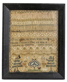
(18th c) SAMPLER by SARAH BROWN born 1780.John McInnis Auctioneers,LLC4.5(505)See Sold PriceFeb 25, 2024
18th c. Cornelis Troost Miniature Portrait of Philips ZweertsHeritage Gallery Auctions4.4(60)See Sold PriceMar 10, 2024
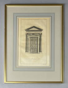
18th C. Etching "A Door of the Composite Order"Epic Auctions and Estate Sales4.6(210)See Sold PriceMar 02, 2024
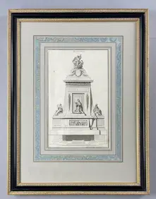
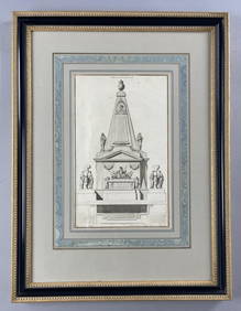
18th C. French Neoclassical Tomb Print IEpic Auctions and Estate Sales4.6(210)See Sold PriceMar 02, 2024
18th C. French Neoclassical Tomb PrintEpic Auctions and Estate Sales4.6(210)See Sold PriceMar 02, 2024
Pair of Chinese Watercolors on Silk Depicting "The Ten Courts of Hell," possibly "The Second CourtCrescent City Auction Gallery4.3(231)See Sold PriceMar 01, 2024
AFTER ANGELICA KAUFMANN, 18TH CENTURY A pair of monochrome stipple engravings, 39 x 33cm, GiltAdam's Auctioneers4.3(5)See Sold PriceFeb 27, 2024
Two (2) Antique 18th C. Copper Engraved Framed Maps - America & EuropeMagnusson Art Group4.5(53)See Sold PriceMar 14, 2024
Map: An 18thC engraved and hand coloured map of Buckinghamshire after Robert Morden. Approx. 8 1/4"Claydon Auctioneers Ltd4.3(125)See Sold PriceFeb 26, 2024
Map: An 18thC engraved and hand coloured map of North America and South America, titled DeClaydon Auctioneers Ltd4.3(125)See Sold PriceFeb 26, 2024
Map: An 18thC engraved map titled A New and Improved Map of Oxfordshire.. after Thomas Kitchin.Claydon Auctioneers Ltd4.3(125)See Sold PriceFeb 26, 2024
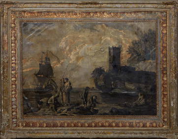
Continental School, "Grisailles Landscape of Figures on the Rocky Shore," 18th/19th c., H.- 36 1/2Crescent City Auction Gallery4.3(231)See Sold PriceMar 09, 2024
C. M. Rols 1800s Antique Print Insecurities Framed SignedKCM Galleries4.7(164)See Sold PriceFeb 25, 2024
ANTIQUE 18TH C FEMALE PORTRAIT WATERCOLOR PAINTINGAntique Arena Inc.4.5(878)See Sold PriceMar 09, 2024