ATLAS of ANTIENT GEOGRAPHY by SAMUEL BUTLER 1843John McInnis Auctioneers,LLC4.5(505)See Sold PriceFeb 24, 2024
18TH C. ANTIQUE MAP: FRENCH & INDIAN WAR, FRAMEDThomaston Place Auction Galleries4.4(394)See Sold PriceFeb 24, 2024
Rand McNally Railroad Map Cabinet w/ 21 Railroad MapsRail & Road Auctions4.6(165)See Sold PriceMar 08, 2024
Keith Haring - Ink on New York Map, Best Buddies, Inscribed, Signed, and DatedSapphire Auction Gallery4.1(67)See Sold PriceMar 02, 2024
LATE 17TH C. FRENCH MAP OF THE NEW WORLD BY ALEXIS-HUBERT JAILLOT (1632-1712)Thomaston Place Auction Galleries4.4(394)See Sold PriceFeb 24, 2024
Central Railroad of New Jersey Map of Sandy Hook Route-ca. 1903JM Hobby Supply and Railroad Artifact Auctions4.4(127)See Sold PriceFeb 24, 2024
Lot of Six Mixed Atlas Box Cars-HO Scale-New in BoxJM Hobby Supply and Railroad Artifact Auctions4.4(127)See Sold PriceFeb 25, 2024
Rand McNally/Santa Fe Railroad Map of Iowa-1912JM Hobby Supply and Railroad Artifact Auctions4.4(127)See Sold PriceFeb 24, 2024
NICOLAES VISSCHER (NETHERLANDS, 1618-1709) MAP OF THE NEW WORLDThomaston Place Auction Galleries4.4(394)See Sold PriceFeb 24, 2024
17TH C. WORLD MAP BY NICOLAES VISSCHER (NETHERLANDS, 1618-1709)Thomaston Place Auction Galleries4.4(394)See Sold PriceFeb 24, 2024
Lot of Six Mixed Atlas Cabooses-HO Scale-New in BoxJM Hobby Supply and Railroad Artifact Auctions4.4(127)See Sold PriceFeb 25, 2024
SoldFour Nautical Maps.Four Nautical Maps. Includes Massachusetts Bay, Lower Guinea (1811), Occidentale Afrique (1738) and a 3-dimensional map of Lake Michigan Largest sight: 14 1/2" x 50 1/2" frame: 16" x 21 3/4"See Sold Price
SoldMAP TRACINGS USED FOR D-DAY LANDINGS AT UTAH AND OMAHAMAP TRACINGS USED FOR D-DAY LANDINGS AT UTAH AND OMAHA BEACHES Lot of four 13"" x 14"" pieces of tracing paper printed with late corrections to nautical maps showing fortifications obstacles etc. usedSee Sold Price
SoldMAP TRACINGS USED FOR D-DAY LANDINGSMAP TRACINGS USED FOR D-DAY LANDINGS Lot of four 13" x 14" pieces of tracing paper printed with late corrections to nautical maps showing fortifications, obstacles, etc., used in the American and BritSee Sold Price
SoldMAP TRACINGS USED FOR D-DAY LANDINGS AT UTAH AND OMAHAMAP TRACINGS USED FOR D-DAY LANDINGS AT UTAH AND OMAHA BEACHES Lot of four 13"" x 14"" pieces of tracing paper printed with late corrections to nautical maps showing fortifications obstacles etc. usedSee Sold Price
Sold1817 American Coast Pilot by Blunt Nautical MAPS1817 American Coast Pilot by Blunt Nautical MAPS Navigation Lighthouses Harbors Originally printed in 1796 (Adams), Edmund Blunt’s ‘American Coast Pilot’ was one of the earliest American works oSee Sold Price
SoldAntique 19c. Nautical Maps James Imray Sons LondonAntique 19c. Nautical Maps James Imray Sons London Publisher North Sea China Coast Sudan Strait River Plate. Comes with bone weight. Each map displays toning and foxing, edge wear and tears, box displSee Sold Price
SoldNAUTICAL MAP OF THE ANTILLESA Chart of the Antilles or Caribs Islands with the Virgin Isles. Hand colored. Relief shown pictorially. Depths shown by soundings. Professionally framed, non glare.Measures 21 1/2"x24"x1 1 1/4". PROVSee Sold Price
van Keulen: Antique Nautical Map of Sicily Italy, 1724Large and rare nautical antique chart of Sicily, Italy. 'Nieuwe Afteekening van het Eyland en Koninkryk Sicilia Vertoonende alle desselfs Zee Havenen Anker Plaetsen Riviere Dieptens Klippen Steeden enSee Sold Price
SoldLot of Four Nautical ItemsA grouping of four nautical items to include a John Browning telescope in wood case; an unmarked brass telescope; a brass-bound wooden ship's wheel; and a green glass float. Telescope in case: 6 in taSee Sold Price
SoldFOUR NAUTICAL LANTERNSBrass and copper, condition fair,FOUR NAUTICAL LANTERNSBrass and copper, condition fair, some glass damage, one marked "anchor".See Sold Price
SoldFour Nautical ScenesMarine artwork contained in glazed frames of approximately the same size. 15 1/2"H x 20 1/2"WSee Sold Price
SoldSix 18th and Early 19th Century Nautical Mapsall shrink-wrapped behind mats, titled as follows: Harbour on the Coast of Chili (1770); Port of Permambuco (1816); Chart of New Zealand (1817); Chart of the Intertropical & West Coasts of AustraliaSee Sold Price
SoldFOUR MAPS OF INDIAN TERRITORY AND SOUTH WEST, 19TH CEN.Includes an 1872 Gray's Atlas map of Indian Territory, by G.W. & C.B. Colton, 13.75 x 17 inches. An A.A. Grant 'Railroad and County Map of Indian Terr.,' 17.25 x 23.5 inches. Two similar Wells, FargoSee Sold Price
SoldFOUR NAUTICAL INSTRUMENTS"Negus Taffrail Log", NortonFOUR NAUTICAL INSTRUMENTS"Negus Taffrail Log", Norton voltmeter, and another brass log.See Sold Price
Four Maps of Yosemite 1910 -1925[YOSEMITE]. Four Maps of Yosemite 1910 -1925. California : Southern Pacific and others, 1910 - 1925. Four items. Illustrated. Approximately 9 x 4 inches folded, printed in colours on white or tan papeSee Sold Price
SoldGroup of Four Nautical Battle LithographsGroup of Four Nautical Battle Lithographs. L. Haghe, after J.C. Schetky, The Chesapeake & The Shannon, (London), 1830. Medium: Hand colored lithographs. Size approximately 26.25" x 29.75" (frame); 15"See Sold Price
Sold3 Nautical Maps inc. Southern 18611st item: Nautical Map: A New Chart of the Western or Atlantic Ocean, Drawn from the Best Authorities by J. S. Norie, printed London, 1831. Shows the coasts of the United States, Labrador and EskmauxSee Sold Price
SoldPORTULANS ancient nautical maps in the Este library‘Portulans’ are medieval nautical maps, provided with a wealth of geographical coastal names, conceived for being used by seafarers. Due to the fact that they used to be frequently rolled up and cSee Sold Price
SoldFour maps of Wyoming, framed and matted, largestFour maps of Wyoming, framed and matted, largest Copyright 1896 by Wm. Bradley & Bros. 15”x21.5”, 2 approx. 11.25”x14”, smallest 9.75”x12.75”See Sold Price
SoldTWO FRAMED ENGLISH NAUTICAL MAPScomprising 'Harwich Harbor' and 'Great Circle Sailing Chart of the North Atlantic Ocean' Harwich Harbor: 27 x 52 inches sight; the other, 32 1/4 x 38 1/2 inches sightSee Sold Price
SoldMODERN FRAMED GREAT LAKES NAUTICAL MAPSMODERN FRAMED GREAT LAKES NAUTICAL MAPS, 2, 36" X 48" & 33" X 40":"Great Lakes - St.. Lawrence River", 2009 and "Lake Huron", 2005.See Sold Price
SoldFour Maps of Idaho largest 20 1/4 x 16 inchesFour Maps of Idaho includes Johnson's Nebraska, Dakota, Idaho and Montana map (published by A.J. Johnson, New York ca. 1865), the Railroad and County Map of Idaho (published by A.A. Grant, New York, 1See Sold Price
SoldGroup of Four Maps of New MexicoFour maps of New Mexico. (1) New Mexico. From King's Handbook of the United States. Page 489 - 7 3/4 x 5 1/2 inches (2) "Sketch accompanying Col. Price's Despatch of 18 April 1847." Map of the BattleSee Sold Price
Chicago Burlington and Quincy RR July 5, 1894 Public TimetableJM Hobby Supply and Railroad Artifact Auctions4.4(127)See Sold PriceFeb 24, 2024
New York Central and Hudson River RR Public Timetable-November 3, 1901JM Hobby Supply and Railroad Artifact Auctions4.4(127)See Sold PriceFeb 24, 2024
19thc Colton Map, Comparitive Size of Lakes & IslandsConnoisseur Auctions3.9(337)See Sold PriceFeb 24, 2024
General Books - Four Maps of Great Britain Designed by Matthew Paris About A.D. 1250TimeLine Auctions Ltd.4.6(184)See Sold PriceMar 08, 2024
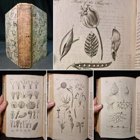
1797 Universal Magazine BOTANY PLATES Flowers FRUIT 12 Copper Engraved PlatesPrivate NY Collection4.2(22)See Sold PriceMar 01, 2024
Arrowsmith & Lewis - Map of PolynesiaTrillium Antique Prints & Rare Books4.5(33)See Sold PriceFeb 24, 2024
Arrowsmith & Lewis - Map of North AmericaTrillium Antique Prints & Rare Books4.5(33)See Sold PriceFeb 24, 2024
Arrowsmith & Lewis - Map of the World on Mercator's ProjectionTrillium Antique Prints & Rare Books4.5(33)See Sold PriceFeb 24, 2024
Arrowsmith & Lewis - Map of LouisianaTrillium Antique Prints & Rare Books4.5(33)See Sold PriceFeb 24, 2024
Arrowsmith & Lewis - Map of the United StatesTrillium Antique Prints & Rare Books4.5(33)See Sold PriceFeb 24, 2024
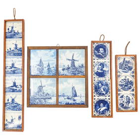
(4 Pc) Delft Blue & White Porcelain Tile Hanging Wall PlaquesAkiba Galleries4.7(1.8k)See Sold PriceFeb 29, 2024
Southern Africa Cape of Good Hope-Madagascar ADMIRALTY sea chart 1935 (1955) mapJasper524.5(9.9k)See Sold PriceFeb 28, 2024
Vintage Framed Cat Island Nautical Map PrintRapid Estate Liquidators and Auction Gallery4.5(1.1k)See Sold PriceFeb 25, 2024