SoldSeven 19th C. Maps of U.S. StatesLot of seven 19th C. maps of Florida and Georgia. Various dates and publishers.See Sold Price
SoldTwo 19th C. Maps of U.S. StatesLot of two mid-19th C. maps of Massachusetts, Rhode Island, and Connecticut. Various dates and publishers.See Sold Price
SoldSeven 19th C. Maps of U.S. StatesLot of seven 19th C. maps of various U.S. states, including Connecticut, Missouri, South Carolina, Alabama, Iowa, Arizona/New Mexico, Minnesota. Various dates and publishers.See Sold Price
SoldSix 19th C. Maps of U.S. StatesLot of six 19th C. maps of Michigan and Maine. Various dates and publishers.See Sold Price
Sold19th c. Map of Virginia and Maryland2 19th c. maps of US states 1). Map of Virginia and Maryland with a plan of Washington and Georgetown. 2). Map of Kentucky and Tennessee- both copper engravings, published in London in 1831 by Isaac TSee Sold Price
SoldFour 19th C. Maps of the United StatesLot of four mid/late 19th C. maps of the United States. Various dates and publishers.See Sold Price
Sold3 19th C. US maps[United States]. 3 Maps. ++ Map Of The Northwest: From Explorations by the United States Engineers & Royal Engineers of England and Union & Northern Pacific R.R. Surveys. Charts northern US and southeSee Sold Price
SoldFour 18th c. US Maps, Mainly SouthernFour (4) 18th c. maps of southern United States. 1st item: Abraham Bradley Jr. "Map of the Southern Part of the UNITED STATES OF AMERICA" drawn and engraved for Morse's American Gazetteer. Boston, 179See Sold Price
Sold19TH C. US NAVY KNIFE, WHISTLE & 4 ITEMS (6)US Navy knife with name (?) and "188" engraved on handle, blade marked "United States Navy", and Monkey Fist macrame lanyard; carved whistle; and four other tools. 5 inchesSee Sold Price
SoldPOSTAGE STAMPS 19TH - 20TH C. US & FOREIGN - LOTLOOSE POSTAGE STAMPS 19TH - 20TH C. US & FOREIGN, LARGE LOT Four incomplete books of stamps, with a quantity of 100+, from the United States and other countries; dating late 19th century to mid-20th cSee Sold Price
SoldFour 19th Century Maps Pertaining to the Western Unitedas follows: Geological Map of a Part of the State of California Explored in 1855 by Lieut. R. S. Williamson U.S. Top Engr (Washington: War Department, 1856); color-coded (24.5 x 19.25 in.) (Some edgeSee Sold Price
SoldFour Edged WeaponsUnited States,C. 19th century A U.S. Model 1860 naval cutlass (brass guard missing) marked on the ricasso with light Ames markings and "1862," an unmarked socket bayonet, and two Trapdoor SpringfieldSee Sold Price
SoldGroup of Twenty-Four Hand-Colored MapsGroup of Twenty-Four Antique Hand-Colored Maps , 17th to 19th c., majority showing provinces of Europe, unframed. Provenance: Property deaccessioned from the Louisiana State Museum, proceeds to be useSee Sold Price
Important 19th century Georgia map,Map of the State of Georgia, Prepared from actual Surveys and other Documents for Eleazer Early," by Daniel Sturges (c.1765-1823), engraved by Samuel Harrison, 1818, four-quadrant map separated into fSee Sold Price
SoldFour 19th C. Maps of the WorldLot of four 19th C. maps of the world. Various dates and publishers.See Sold Price
SoldFour 19th C. Maps of the Western HemisphereLot of four early 19th C. maps of countries in the western hemisphere, including St. Vincent, Grenada/Tobago/Curacao/Trinidad, Caracas/Guiana/Peru/Chile/La Plata. Various dates and publishers.See Sold Price
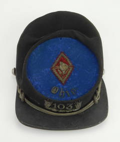
Sold19TH C. US STATE MILITIA UNIFORM BUTTONS LOT OF 1519TH C. US STATE MILITIA UNIFORM BUTTONS LOT OF 15 19th Century state militia military uniform buttons lot of 15. 7th Regiment National Guard button by D. Evans & Co. Attleboro Mass. West Virginia MilSee Sold Price
Sold1862 Bowen Civil War Map, Other 19th C. MapsFour 19th c. maps: 1. Framed Bowen's "Map of the Field Operations of the Army of Virginia during the Months of July and August 1862"; report of Maj. Gen. John Pope to the Committee on the Conduct of tSee Sold Price
SoldFour 19th c Lithographs of US GeneralsFour Lithographs of Union Civil War Generals- Bingham and Dodd -Major Genl. P.H. Sheridan 20 x 15"; Currier and Ives New York- Majr Genl George G Meade 15 x 12"; Currier and Ives- Brig. Genl Franz SieSee Sold Price
SoldTwo 19th C. MapsTwo framed 19th C. maps: the United States; Mexico/California/Texas. Various dates and publishers.See Sold Price
SoldTwo American 19thC MapsTwo American 19thC Maps, A) 19thC map of United States western states, including California, Oregon, Utah, Washington, New Mexico, Nebraska, Kansas, Indian Territory, framed and matted under glass, siSee Sold Price
Sold18TH & 19TH C. UNITED STATES MAPS;Seven include: "An Improved Map of Vermont," Lewis Bros. Reading 1850, "Carte des Parties Nord et Ouest de L'Amerique," etc. (some framed); Largest: 27" x 21"See Sold Price
Sold19TH C MAPS BY ORRIN POTTER U.S. and CONNECTICUTTWO EARLY 19TH C MAPS BY ORRIN POTTER: 1) Map of CONNECTICUT by Orrin Potter, Plymouth 1816, with key showing roads, county lines, court houses, meeting houses, and mountains, 19" x 14 1/2". 2) detailSee Sold Price
Sold19th C Hand Colored Map of State of Maine FRAMEDPublished by S.Augustus Mitchell, Jr. having a published date year of 1860. This hand colored map contains maps of the various countries of the world and plans of cities. Inset at lower right featuresSee Sold Price
19thc Colton Map, Comparitive Size of Lakes & IslandsConnoisseur Auctions3.9(336)See Sold PriceFeb 24, 2024
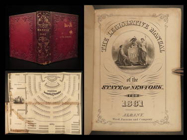
1861 Civil War Legislative Manual New York 84th Congress US Captain PROVENANCESchilb Antiquarian Rare Books4.8(428)See Sold PriceMar 31, 2024
RUSSIAN ORTHODOX GILT BRONZE FOLDING TRAVEL ICONAustin Auction Gallery4.7(1.2k)See Sold PriceFeb 25, 2024
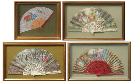
Group of Four Folding Hand Fans, 19th c., Largest- Seaside- H.- 9 in., W.- 18 in. (4 Pcs.)Crescent City Auction Gallery4.3(231)See Sold PriceMar 01, 2024
Group of Four Ninth Plate Photographs, 19th c., consisting of three tintypes of gentlemen withCrescent City Auction Gallery4.3(231)See Sold PriceMar 01, 2024
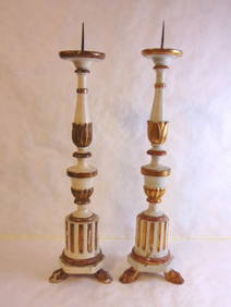
A Set Of Four 19th C. French Louis XVI Ormolu Sconces, Attrib. Henry DassonFive Star Auctions4.2(3)See Sold PriceFeb 29, 2024
Map: A 19thC engraved and hand coloured map of Buckingham titled A New Map of BuckinghamshireClaydon Auctioneers Ltd4.3(125)See Sold PriceFeb 26, 2024
Set of Four ( 4 ) Adrian Pearsall Model 1613-C Dining Chairs for Craft Associates c. 1960sBidhaus4.4(762)See Sold PriceFeb 26, 2024
Rare 19thc Colton Map, Argentine Republic, Chile, Uruguay, PataguayConnoisseur Auctions3.9(336)See Sold PriceMar 16, 2024
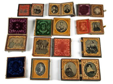
19th C. Photos Daguerreotype, Ambrotype & Tintypes (10)Artemis Fine Arts4.8(1.4k)See Sold PriceMar 01, 2024