SoldTwo 19th C. MapsTwo framed 19th C. maps: the United States; Mexico/California/Texas. Various dates and publishers.See Sold Price
SoldTwo 19th c Maps19th c Atlas page map of Norway - Partie de la Suede et de la Norwege on two sheets plate 22x 19"; 1855 Colton map of Cuba, Jamaica and Puerto Rico 12 x15"See Sold Price
SoldMap LotLot two 19th c. maps inluding "Map Of Orange County Vermont 1853" (H.F. Walling), 57" x 55", along with 1899 New England map (as found).See Sold Price
SoldTwo Late 19th C. Maps Showing Indian Reservationsboth "Compiled Under The Direction Of The Hon. T.J. Morgan", dated 1890 and 1891, both being 23 5/8" x 34 3/4"See Sold Price
SoldTwo 19th C English Hunting MapsTwo 19th C English folding hunting maps. Fine with each measuring 11 x 8". Please note that this lot has a confidential reserve. When you leave a bid in advance of the auction, submit your maximum. ThSee Sold Price
SoldThree 19th C. Maps & Two 19th C. Prints**Originally Listed At $100** Europe, Ireland and Germany, ca. 19th century CE. A collection of printed materials: two printed German maps, one print of an older engraved map, and two prints of engravSee Sold Price
SoldFRAMED 19TH C MAP & TWO FRAMED PORTRAITSLot including a framed 19th century map of the West Indies, and two framed photograph portraits (old man and old woman). Condition: map show creases and signs of age/wear, discoloration, heavy signs oSee Sold Price
SoldMAPS, 2, 19TH C., 12" X 16", CANADA & MICHIGANMAPS, TWO, 19TH C., 12" X 16", CANADA & MICHIGAN:Including 1 engraved by J. & C. Walker, "North America: Sheet V, The North West and Michigan Territories", published by Baldwin & Cradock, 1833, 12 1/2See Sold Price
Sold(2) Late 19th c. maps of Ireland, unframedTwo late 19th century colored maps of Ireland, comprising a map of Ireland printed for The Century Atlas, circa 1897, 16"h x 11"w, unframed, and a map of Ireland printed for The Society for the DiffusSee Sold Price
SoldTwo 19th C. Books on World Travel and HistoryIncludes Travels and Adventures of the Most Celebrated Travelers in all Parts of the World by Henry Howe dated 1860 and The Earth Girdled by T. DeWitt Talmadge dated 1896. See photos for condition andSee Sold Price
SoldTWO 19TH C BOUND ATLASES TO INCLUDE NEW BEDFORD1881, PUBLISHED BY GEORGE H. WALKER, BOSTON, MA, 79 PAGES WITH ILLUSTRATIONS AND MAPS. 18" X 14 1/4". SPINE IS BROKEN, CORNERS BADLY SCUFFED, BLANK FRONTISE AND TITLE PAGE ARE TORN. THE REST OF THE ATSee Sold Price
SoldTWO 19TH C. TRAVEL BOOKS, TO INCLUDEMITCHELLS TRAVEL GUIDE, WITH MAP 1836, TOGETHER WITH POCKET GAZETTEER OR TRAVELER'S GUIDE THROUGH NORTH AMERICAN AND THE WEST INDIES BY BISHOP DAVENPORT BALTIMORE, CUSHING & SONS 1838See Sold Price
Two 19th C. Japanese PrintsLot of two 19th century Japanese prints, depicting one continuous image of map with calligraphy, 59" h x 27 1/2" w. Provenance: From a California estate.See Sold Price
Sold3 - Japanese Ceramics; Map Vase, Sake Vase3 - Japanese Ceramics; 19th C Map of Japan Vase decorated with blue and white overglaze enamels; together with two Sake Bottles each with calligraphy. Good condition. Height of Map vase 11 1/4 inchesSee Sold Price
Sold19th c Books, Maps, and PrintsCa 1852 Samuel Goodrich "Peter Parley's Cabinet Library" (17 vols), leather, 6 3/4" x 4 1/4", sold with 1896 MacDowell Woodland Sketches as well as two Handcolored 19th c Lithographs, two 1902 NationaSee Sold Price
SoldFour Antique Continental MapsFour Antique Continental Maps , 17th to 19th c., incl. map of Ireland, British Colonies, Virginia, and two bird's-eye-views, largest 18 3/4 in. x 26 in Provenance: Property deaccessioned from the LouiSee Sold Price
SoldGrp: 12 Regional Maps of AfricaGroup of twelve 18th and 19th c. regional maps of Africa. Includes two maps of the North African coast; one map of Madagascar; one page with seven inset maps of the major islands of Africa; one map ofSee Sold Price
SoldThree 19th Century Celestial MapsThree 19th C. celestial maps, framed under glass. Two dated 1835, the other 1832. Published by F.J. Huntington, Connecticut. Sheets measure: 15" x 13-1/2".See Sold Price
SoldTRANQUILLO MOLLO ATLASTRANQUILLO MOLLO ATLAS; Thirty-four maps out of an original fifty-two include America, United Kingdom, Australia, etc., Vienna, late 18th/early 19th c.; Most maps with color; 15'' x 20''See Sold Price
Sold19th C English Hunting MapsTWO folding maps from the early 19th century showing the places of meeting for two hunts. On conducted by Lord Gifford and the other by the Marquis of Hasting. Fine, each 8 x 11". Please note that thiSee Sold Price
SoldTWO ANTIQUE ENGRAVED MAPS OF RUSSIA 19TH CThe lot includes an antique map Russia in Europe by A.K. Johnston from the National Atlas, circa 1857, and Carte de la Russie d’Europe from the Atlas Universel, Paris, circa 1826. Dimensions: SSee Sold Price
Sold19TH C TWO VOL BOOK SET: M HUC, JOURNEY THROUGH CHINA19TH CENTURY TWO VOLUME BOOK SET, A Journey Through the Chinese Empire, by M Huc (New York, 1856, (no previous editions noted), 8" x 5 1/2". First volume includes map. Brown cloth with gilt spine. ConSee Sold Price
SoldMid-19th C Hunting Maps Royal HuntTWO folding early 19th century hunting maps: one for the Royal Hunt and the other for the Albrighton Hunt. Fine condition, each approx. 8 x 13”. Please note that this lot has a confidential reserve.See Sold Price
SoldA.J. JOHNSON, YOUNG & DELLEKER MAPS, WI & MIA. J. JOHNSON (19TH C.) AND YOUNG & DELLEKER, ATLAS MAPS, TWO, 17" X 22", WISCONSIN & MICHIGAN:Including 1 Johnson's map of Wisconsin and Michigan, 17 1/2" x 26", and 1 Michigan Territory map by YoungSee Sold Price
19thc Colton Map, Comparitive Size of Lakes & IslandsConnoisseur Auctions3.9(336)See Sold PriceFeb 24, 2024
TWO (19th c) SCANDINAVIAN PINE PANTRY BOXESJohn McInnis Auctioneers,LLC4.5(505)See Sold PriceFeb 25, 2024
L. Popplein Continental Oil Painting on Canvas, Portait of two women 19th cGlobal Auctions Company4.3(36)See Sold PriceMar 03, 2024
Two 19th C. Chinese Rose Mandarin Brush PotsEpic Auctions and Estate Sales4.6(210)See Sold PriceMar 02, 2024
Two Early 19th C. German Pewter Chargers, I.B. FINCK BLOCKZINNRivich Auction4.5(234)See Sold PriceMar 03, 2024
Two late 19thC / early 20thC Savonarola chairs, the uprights of scrolled form with carved maskClaydon Auctioneers Ltd4.3(125)See Sold PriceFeb 26, 2024
Two 19thC Chinese elm yoke back chairs, with shaped top rails, bowed mid rails and a rushed seatClaydon Auctioneers Ltd4.3(125)See Sold PriceFeb 26, 2024
Map: A 19thC engraved map titled Gloucestershire from the Best Authorities, after John Cary. Approx.Claydon Auctioneers Ltd4.3(125)See Sold PriceFeb 26, 2024
Local Buckinghamshire interest: Two 19thC reward notices, one relating to a person affixing aClaydon Auctioneers Ltd4.3(125)See Sold PriceFeb 26, 2024
1704 DESCRIPTION OF ALL THE SEATS OF THE PRESENT WARS OF EUROPE antique w/ MAPSJasper524.5(9.9k)See Sold PriceFeb 27, 2024
Rare 19thc Colton Map, Argentine Republic, Chile, Uruguay, PataguayConnoisseur Auctions3.9(336)See Sold PriceMar 16, 2024
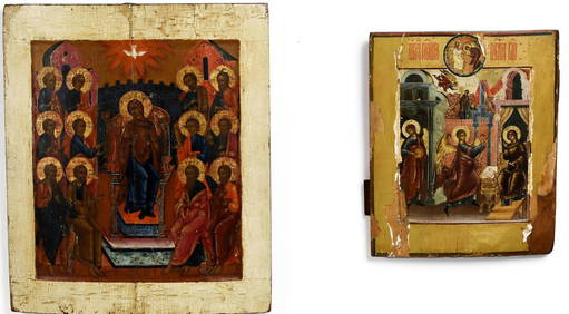
TWO ANTIQUE RELIGIOUS ICONS, THE GRECIAN GALLERY.William Smith Auctions4.6(147)See Sold PriceMar 06, 2024
TWO 19TH C. CHINESE BLANC-DE-CHINE GUANYIN FIGURES.William Smith Auctions4.6(147)See Sold PriceMar 06, 2024
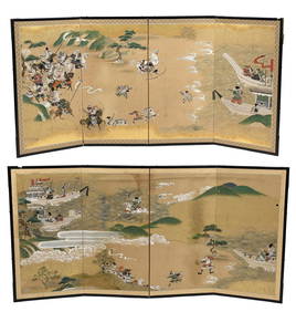
TWO 19TH C. JAPANESE PAINTED FOLDING SCREENS.William Smith Auctions4.6(147)See Sold PriceMar 06, 2024
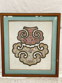
TWO 19TH C. BIRDSEYE MAPLE STANDS, TWITCHELL FARM.William Smith Auctions4.6(147)See Sold PriceMar 06, 2024