ATLAS of ANTIENT GEOGRAPHY by SAMUEL BUTLER 1843John McInnis Auctioneers,LLC4.6(502)See Sold PriceFeb 24, 2024
18TH C. ANTIQUE MAP: FRENCH & INDIAN WAR, FRAMEDThomaston Place Auction Galleries4.4(386)See Sold PriceFeb 24, 2024
Rand McNally Railroad Map Cabinet w/ 21 Railroad MapsRail & Road Auctions4.6(165)See Sold PriceMar 08, 2024
Keith Haring - Ink on New York Map, Best Buddies, Inscribed, Signed, and DatedSapphire Auction Gallery4(67)See Sold PriceMar 02, 2024
LATE 17TH C. FRENCH MAP OF THE NEW WORLD BY ALEXIS-HUBERT JAILLOT (1632-1712)Thomaston Place Auction Galleries4.4(386)See Sold PriceFeb 24, 2024
Central Railroad of New Jersey Map of Sandy Hook Route-ca. 1903JM Hobby Supply and Railroad Artifact Auctions4.4(126)See Sold PriceFeb 24, 2024
Lot of Six Mixed Atlas Box Cars-HO Scale-New in BoxJM Hobby Supply and Railroad Artifact Auctions4.4(126)See Sold PriceFeb 25, 2024
Rand McNally/Santa Fe Railroad Map of Iowa-1912JM Hobby Supply and Railroad Artifact Auctions4.4(126)See Sold PriceFeb 24, 2024
NICOLAES VISSCHER (NETHERLANDS, 1618-1709) MAP OF THE NEW WORLDThomaston Place Auction Galleries4.4(386)See Sold PriceFeb 24, 2024
17TH C. WORLD MAP BY NICOLAES VISSCHER (NETHERLANDS, 1618-1709)Thomaston Place Auction Galleries4.4(386)See Sold PriceFeb 24, 2024
Lot of Six Mixed Atlas Cabooses-HO Scale-New in BoxJM Hobby Supply and Railroad Artifact Auctions4.4(126)See Sold PriceFeb 25, 2024
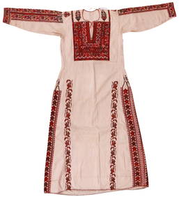
SoldFramed British Schoolgirl Silk Embroidered Map ofFramed British Schoolgirl Silk Embroidered Map of Scotland, oval, silk threads and ground, with title block to upper left, embellished with a kilted gentleman and French knot foliage, titled "A New MaSee Sold Price
SoldEnglish Embroidery, "A Map of England and Wales"English embroidered silkwork, "A Map of England and Wales", showing counties of England, Ireland, Scotland, etc., with colorful image of Brittania upper right and floral surround. Oval, appx 21 1/2" xSee Sold Price
SoldEmbroidered map of United states, 20th centuryFramed embroidered map depicting the United States Flower Map, mid 20th century, overall: 24''h x 34''wSee Sold Price
SoldTallis, John (Pub) 1852 Map. ScotlandSteel Engraved Map with Original Outline Hand Color Published 1852-56 by John Tallis, London for "The Universal Pronouncing Dictionary" by Thomas Wright. Drawn & Engraved by John Rapkin. Centre fold aSee Sold Price
SoldTwo Hand Embroidered MapsTwo Hand Embroidered Maps, a World Map (January 1929) and a USA Map (January 1930), embroidery on linen. Size: 23" x 33", 58 x 84 cm (sight), 25" x 35", 64 x 89 cm (frame). Kristina Barbara Johnson EsSee Sold Price
Sold1813 Embroidered Map of EuropeTitle: 1813 Embroidered Map of Europe Dimension: 20 3/4" x 24 1/4" framed. Materials: Silk on wool Additional Information: G. Smerdon Embroidered Map of Europe Probably Southern English dated 1813 CarSee Sold Price
SoldBarclay, James 1809 Antique Map. Scotland"Scotland or North Britain" Outline Hand Coloured Copper Engraved Map Published 1809, Leeds for "Barclay's Complete and Universal Dictionary of the English Language..." by the Rev. James Barclay. PapeSee Sold Price
SoldEmbroidered Map of USA with State FlowersImage: 17.5" H x 23.5" W; frame: 19.5" H x 26" W x 0.5" D.See Sold Price
SoldSilk embroidered map of England and Wales, datedSilk embroidered map of England and Wales, dated 1804, wrought by Mary Walker, York, 19'' x 15 1/2''.See Sold Price
SoldVictorian silk embroidered map, Eastern and WesternVictorian silk embroidered map, Eastern and Western Hemispheres, 16" x 20". Provenance: The Vincent Family Collection, Fairfield, Connecticut.See Sold Price
SoldGuthrie, William 1790 Antique Map. ScotlandCopper Engraved Map Published 1790, London for "A New Geographical, Historical and Commercial Grammar..." by William Guthrie. The maps are by John Senex, Thomas Kitchin and others. Folds as issued. EaSee Sold Price
SoldElizabeth Wilson, Embroidered Map of the World.Wilson, Elizabeth, Map of the World, c. 1815, embroidered silk, 16" x 27".See Sold Price
Antique Silk Embroidered Map Sampler, Circa 1804An antique with worldly allure, this art piece showcases a map of Europe circa 1804. This relic is outlined by an oval frame with a dark finish for a traditional look.24″w x 27.5″h x 1RSee Sold Price
SoldMAP, Scotland, Robert de VaugondyScotland. Gilles Robert de Vaugondy, Le Royaume d'Ecosse Divise en Shires ou Comtes, from Atlas Universel, 1751 (dated). Hand Color. This handsome map of Scotland delineates the counties and shows couSee Sold Price
SoldRare Map Scotland by Alan Bell 1839Bell, Alan : MAP - RUSSIA IN EUROPE - FROM BELL'S ATLAS PUBLISHED IN 1839 Published in 1839, 1st Edition drawn by Allan Bell. This map is in very good condition, full borders as published, folded as pSee Sold Price
SoldEmbroidered map of England and Wales, stains andEmbroidered map of England and Wales, stains and losses, 11 1/2" x 11"See Sold Price
SoldSilk Embroidered Map of Spain & Portugal. FramedSilk Embroidered Map of Spain & Portugal. Framed in Period Frame. Ferdinand Isabelle. -- Dimensions: Image Size: H: 6 inches: W: 7 inches --- US Shipping charge: $35See Sold Price
SoldAntique Silk Embroidered Map Sampler, Circa 1804An antique with worldly allure, this art piece showcases a map of Europe circa 1804. This relic is outlined by an oval frame with a dark finish for a traditional look.24″w x 27.5″h x 1RSee Sold Price
SoldA GEORGE III SILKWORK EMBROIDERED MAP OF EUROPE ,A GEORGE III SILKWORK EMBROIDERED MAP OF EUROPE , CIRCA 1800. Finely stitched after the original "Europe and its empires, kingdoms and states" by Thomas Kitchen, within a reverse painted glass and gilSee Sold Price
SoldAn embroidered map sampler of England and Wales byAn embroidered map sampler of England and Wales by Elizabeth Colyer, early 19th century, the ground worked with the counties in brown silk, the county names in black silk, border embroidered with flowSee Sold Price
SoldAn embroidered map sampler by Anna Maria Claridge,An embroidered map sampler by Anna Maria Claridge, November 12, 1800, the fine wool ground worked with the counties of England and Wales, within verre eglomise mounts and gilt frame, 56cm, 22inSee Sold Price
SoldEmbroidered map of Western Hemisphere with Zodiac signsHeading: (Embroidered Map) Author: Title: Eighteenth century embroidered map on silk of the Western Hemisphere, with color vignettes in the corners, the whole surrounded by signs of the zodiac PlaceSee Sold Price
Sold(MAP, SCOTLAND) BLEAU, J. A group of 2 hand-colore(MAP, SCOTLAND) BLEAU, J. A group of two hand-colored copper engraved maps of British Isles. (Amsterdam: J. Blaeu, 1654). Each with richly hand-colored borders, forests, mountain ranges and towns, decSee Sold Price
ALEXANDER BALD 1780 1st Edition Scotland Corn Dealer Agriculture AssistantLuis Porretta Fine Arts4.3(10)See Sold PriceMar 02, 2024
LATE 16TH C. MAP OF SCOTLAND BY MERCATOR, FRAMEDThomaston Place Auction Galleries4.4(386)See Sold PriceFeb 24, 2024
PHILIP NORMAN FSA Hand Colored Engraving c1910 Loch White Fairies SIGNED Listed ScotlandLuis Porretta Fine Arts4.3(10)See Sold PriceMar 02, 2024
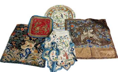
Various Antique Chinese Embroidered Fabric Rank Badges From Silk Robes Phoenix Foo GoldHess Fine Auctions4.5(197)See Sold PriceMar 02, 2024
Portfolio of 15 County Maps by Robert Morden (English 1650-1703)Nadeau's Auction Gallery4.7(401)See Sold PriceFeb 24, 2024
Vintage Golf Themed Pillows, Old Course St. Andrews Scotland, Golf Club, Embroidered Gold BullionHoch LTD.4.5(73)See Sold PriceFeb 25, 2024
Chatelain - 3 Maps of the British Isles (England, Ireland, Scotland)Trillium Antique Prints & Rare Books4.5(30)See Sold PriceFeb 24, 2024
De Jode, Rare, pub. 1593 - Map of the British Isles [England, Scotland, Ireland] (Angliae Scotiae etTrillium Antique Prints & Rare Books4.5(30)See Sold PriceFeb 24, 2024
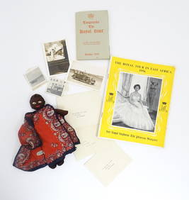
A quantity of Royal ephemera relating to Princess Margaret's Royal Tour of East Africa September -Claydon Auctioneers Ltd4.3(125)See Sold PriceFeb 26, 2024
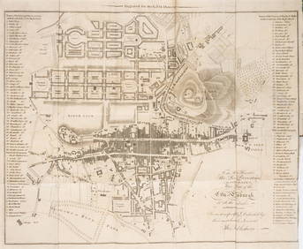
Map: A 17thC engraved and hand coloured map of Scotland titled Strath-Navernia / Strath Navern afterClaydon Auctioneers Ltd4.3(125)See Sold PriceFeb 26, 2024
VARIOUS ARTISTS [BRITISH TRAVEL GUIDES]. Group of 6 map booklets and flyers. 1930s.Swann Auction Galleries4.4(65)See Sold PriceFeb 29, 2024
Scotland.- Sir Walter Scott's Edinburgh.- The Post-Office annual directory, from Whitsunday 1808, toForum Auctions4.3(52)See Sold PriceFeb 29, 2024
[FROM PENICUIK HOUSE] GROUP OF SIX SILK EMBROIDERED PANELSLyon & Turnbull4.3(51)See Sold PriceMar 13, 2024


![De Jode, Rare, pub. 1593 - Map of the British Isles [England, Scotland, Ireland] (Angliae Scotiae et (1 of 2)](https://p1.liveauctioneers.com/6581/319571/171593327_1_x.jpg?height=282&quality=70&version=1707853304)

![VARIOUS ARTISTS [BRITISH TRAVEL GUIDES]. Group of 6 map booklets and flyers. 1930s. (1 of 2)](https://p1.liveauctioneers.com/199/319703/171640571_1_x.jpg?height=282&quality=70&version=1707943705)


![[FROM PENICUIK HOUSE] GROUP OF SIX SILK EMBROIDERED PANELS (1 of 1)](https://p1.liveauctioneers.com/94/320325/172143438_1_x.jpg?height=282&quality=70&version=1708531096)

