SoldEmbroidered map of England and Wales, stains andEmbroidered map of England and Wales, stains and losses, 11 1/2" x 11"See Sold Price
SoldVictorian Silk Embroidered Map, England & WalesVictorian Silk Embroidered Map of England & Wales Dimensions: 24 1/4" H x 21 1/2" W (ELB608)(MS)See Sold Price
SoldEmbroidered Map of England & Wales by MC Saul, 1785Finely embroidered map of England and Wales with locations identified. Overall toning and areas of staining. 20"h x 15.25"wSee Sold Price
SoldSilk embroidered map of England and Wales, datedSilk embroidered map of England and Wales, dated 1804, wrought by Mary Walker, York, 19'' x 15 1/2''.See Sold Price
SoldEmbroidered map of England and WalesCharming work with representations of various regions. Framed: 28in. (72cm) height; 21in. (53cm) widthSee Sold Price
SoldEmbroidered map of England and Wales on silk datedEmbroidered map of England and Wales on silk dated 1805, depicting St. George's Channel, Irish Sea, British Channel, German Ocean surrounded by garland swags, lower right Mansfield School 1805, overalSee Sold Price
SoldA Regency embroidered map of England and Wales, siA Regency embroidered map of England and Wales, signed Joanna Parsons and dated 1819, the county names, boundaries and prominent towns detailed, within an oval border of flowers and foliage,See Sold Price
SoldA silk map of EnglandA George III silkwork embroidered map of England and Wales, circa 1800, within a reverse painted glass and giltwood frame, 65c, high, 60cm wideSee Sold Price
Sold18th/19th C. petipoint map of EnglandLate 18th/early 19th C. framed 21" x 18" oval petipoint & embroidered county map of England & Wales, set in original hand carved gesso gilt oval frame, overall size 25" x 22"See Sold Price
Silk Needle Work Map of England c. 1791LOW BUYERS PREMIUM (10%) NO RESERVE AUCTION! BIDDING STARTS AT $10! This is an amazing Silk on Silk Embroidered Map of England and Wales with the Artists Initials M.B. and the year 1791 Embroidered NeSee Sold Price
SoldFramed British Schoolgirl Embroidered Map of EnglFramed British Schoolgirl Embroidered Map of England and Wales, signed Sarah Goulden, 1818, oval format, stitched in silk on linen ground, with running foliate border, black and gold verre eglomise glSee Sold Price
Framed British Schoolgirl Embroidered Map of EnglaFramed British Schoolgirl Embroidered Map of England and Wales, signed Sarah Goulden, 1818, oval format, stitched in silk on linen ground, with running foliate border, black and gold verre eglomise glSee Sold Price
Silk Needle Work Map of England c. 1791LOW BUYERS PREMIUM (10%) NO RESERVE AUCTION! BIDDING STARTS AT $10! This is an amazing Silk on Silk Embroidered Map of England and Wales with the Artists Initials M.B. and the year 1791 Embroidered NeSee Sold Price
SoldAn embroidered map sampler of England and Wales byAn embroidered map sampler of England and Wales by Elizabeth Colyer, early 19th century, the ground worked with the counties in brown silk, the county names in black silk, border embroidered with flowSee Sold Price
SoldEmbroidered Silk Sample Map of England & WalesEnglish, late 18th/ early 19th century. A silk embroidered needlework map depicting England and Wales, in an oval form surrounded by a border on tondo of blue, pink, and purple flowers. Framed 37.5" xSee Sold Price
A George III embroidered silk map of England and WA George III embroidered silk map of England and Wales, by Ann Hooper, Box School, 1791, depicting the counties, within a polychrome border depicting meandering floral branches, framed and glazed, 61cSee Sold Price
SoldEnglish Embroidery, "A Map of England and Wales"English embroidered silkwork, "A Map of England and Wales", showing counties of England, Ireland, Scotland, etc., with colorful image of Brittania upper right and floral surround. Oval, appx 21 1/2" xSee Sold Price
SoldAn early 19th century silk embroidered map depictAn early 19th century silk embroidered map depicting the counties of England and Wales, signed Mary Joyce, 53 cm x 46 cmSee Sold Price
SoldEMBROIDERED/PETITE POINT PANELEMBROIDERED/PETITE POINT LINEN PANEL, MAPS OF ENGLAND AND WALES, SIGNED MARGARET ANBEON 1805. SIGHT 20 1/2 X 17 3/4" CONDITION REPORTS ARE BRIEF WHEN INCLUDED IN THE DESCRIPTIONS, PERSPECTIVE BUYERS SSee Sold Price
SoldEnglish silk embroidery map 19th centurEnglish silk embroidery map 19th century oval field with floral embroidered border, centering crewel work outline map of England and Wales stitched with county names; framed in an oval gilt-painted frSee Sold Price
SoldAn embroidered map sampler by Anna Maria Claridge,An embroidered map sampler by Anna Maria Claridge, November 12, 1800, the fine wool ground worked with the counties of England and Wales, within verre eglomise mounts and gilt frame, 56cm, 22inSee Sold Price
Embroidery.- A Map of England and WalesEmbroidery.- A Map of England and Wales,map sampler by Susanna Morgan, Llanwern, Monmouthshire, title cartouche and script in the North Sea, compass in the English Channel, silk embroidered maSee Sold Price
Embroidery.- A Map of England and WalesEmbroidery.- A Map of England and Wales,map sampler by Susanna Morgan, Llanwern, Monmouthshire, title cartouche and script in the North Sea, compass in the English Channel, silk embroidered maSee Sold Price
Antique War of the Roses embroidered Sampler Map"A Map of England and Wales" is Embroidered by Elizabeth Winterflood the top left in a bud like form, below next to her name the date is marked with roman numerals MDCCXCVII ( it is either 1712 or 181See Sold Price
OGILVY & BOWEN c1736 Original Map of Oxfordshire Berkshire Etc.Luis Porretta Fine Arts4.3(10)See Sold PriceMar 02, 2024
Numismatic Books - Boyne - Tokens Issued in the Seventeenth Century in England, Wales, and IrelandTimeLine Auctions Ltd.4.5(183)See Sold PriceMar 09, 2024
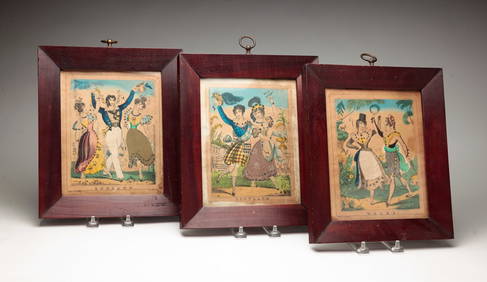
THREE HAND COLORED AND ADORNED PRINTS.Amelia Jeffers, Auctioneers & Appraisers4.6(101)See Sold PriceMar 08, 2024
Late 18th century map of England and Wales sampler and two printsFellows4.3(159)See Sold PriceMar 05, 2024