ATLAS of ANTIENT GEOGRAPHY by SAMUEL BUTLER 1843John McInnis Auctioneers,LLC4.6(502)See Sold PriceFeb 24, 2024
18TH C. ANTIQUE MAP: FRENCH & INDIAN WAR, FRAMEDThomaston Place Auction Galleries4.4(386)See Sold PriceFeb 24, 2024
Rand McNally Railroad Map Cabinet w/ 21 Railroad MapsRail & Road Auctions4.6(165)See Sold PriceMar 08, 2024
Keith Haring - Ink on New York Map, Best Buddies, Inscribed, Signed, and DatedSapphire Auction Gallery4(67)See Sold PriceMar 02, 2024
LATE 17TH C. FRENCH MAP OF THE NEW WORLD BY ALEXIS-HUBERT JAILLOT (1632-1712)Thomaston Place Auction Galleries4.4(386)See Sold PriceFeb 24, 2024
Central Railroad of New Jersey Map of Sandy Hook Route-ca. 1903JM Hobby Supply and Railroad Artifact Auctions4.4(126)See Sold PriceFeb 24, 2024
Lot of Six Mixed Atlas Box Cars-HO Scale-New in BoxJM Hobby Supply and Railroad Artifact Auctions4.4(126)See Sold PriceFeb 25, 2024
Rand McNally/Santa Fe Railroad Map of Iowa-1912JM Hobby Supply and Railroad Artifact Auctions4.4(126)See Sold PriceFeb 24, 2024
NICOLAES VISSCHER (NETHERLANDS, 1618-1709) MAP OF THE NEW WORLDThomaston Place Auction Galleries4.4(386)See Sold PriceFeb 24, 2024
17TH C. WORLD MAP BY NICOLAES VISSCHER (NETHERLANDS, 1618-1709)Thomaston Place Auction Galleries4.4(386)See Sold PriceFeb 24, 2024
Lot of Six Mixed Atlas Cabooses-HO Scale-New in BoxJM Hobby Supply and Railroad Artifact Auctions4.4(126)See Sold PriceFeb 25, 2024
SoldDESILVER, CHARLES. A New Map of Nebraska, Kansas, NewDESILVER, CHARLES. A New Map of Nebraska, Kansas, New Mexico, and Indian Territories. Hand-colored lithographed map of mid-continent North America. 17½x14 inches sheet size, ample margins; sheetSee Sold Price
SoldDesliver map of Nebraska, Kansas, New MexicoTitle: A New Map of Nebraska, Kansas, New Mexico and Indian Territories Author: Desilver, Charles Description: Lithographed map, hand-colored. 37.5x30.5 cm. (14¾x12") plus decorative border.The westSee Sold Price
SoldDesliver map of Nebraska, Kansas, New MexicoTitle: A New Map of Nebraska, Kansas, New Mexico and Indian Territories Author: Desilver, Charles Description: Lithographed map, hand-colored. 37.5x30.5 cm. (14¾x12") plus decorative border.The westSee Sold Price
1853 MAP: COWPERTHWAITE'S NEBRASKA, KANSAS AND NEW MEXIA New Map of Nebraska, Kansas, New Mexico and Indian Territories issued by Thomas, Cowperthwaite & Co, Pennsylvania 1853-1854, published by Charles Desilver, hand colored map full sheet size: 17 incheSee Sold Price
Sold9 maps of western US. 7 publ Asher & Adams, (1872[United States: West]. 9 Maps. ++ A New Map Of Nebraska, Kansas, New Mexico And Indian Territories. From ''A New Universal Atlas,'' DeSilver, 1857. ++ A New Map Of The State Of California, The TerritoSee Sold Price
Sold(PENNSYLVANIA.) Desilver, Charles. A New Map o(PENNSYLVANIA.) Desilver, Charles. A New Map of the State of Pennsylvania. Hand-colored engraved folding pocket map, 385x450 mm; folds into the original 12mo format cloth case. Philadelphia, 1857 AllSee Sold Price
SoldPocket Map of Pennsylvania including New Jersey.MAP - DESILVER, Charles. A New Map of the State of Pennsylvania including New Jersey.Philadelphia: Desilver, 1860. Engraved folding pocket map, hand-colored in outline (475x740 mm). Folds inSee Sold Price
SoldCharles DESILVER 1856 Map of New YorkRARE 1856 Map of the "THE STATE OF NEW YORK" Compiled from the latest authorities of Philadelphia by CHARLES DESILVER. Unframed in and age appropriate condition as shown. See photos.See Sold Price
SoldDesilver map of California, etc., 1854Title: A New Map of the State of California, the Territories of Oregon, Washington, Utah & New Mexico Author: Desilver, Charles Description: Lithographed map, hand-colored. 38x30 cm. (15x11¾") plus dSee Sold Price
SoldDesilver map of California, etc., 1856Title: A New Map of the State of California, the Territories of Oregon, Washington, Utah & New Mexico Author: Desilver, Charles Description: Lithographed map, hand-colored. 38x30 cm. (15x11¾") plus dSee Sold Price
Desilver map of California, etc., 1856Title: A New Map of the State of California, the Territories of Oregon, Washington, Utah & New Mexico Author: Desilver, Charles Description: Lithographed map, hand-colored. 38x30 cm. (15x11¾") plus dSee Sold Price
SoldMitchell, A New Map of the State of Iowa.MITCHELL, Samuel Augustus (1790-1868). A New Map of the State of Iowa. Philadelphia: Charles Desilver, c. 1856. Lithographed, original hand color in full.14 x 17 ½ inches (unframed).See Sold Price
Sold"A New Map of Louisiana with its canals, roads, &"A New Map of Louisiana with its canals, roads, & distances from place to place, along the stage & steam boat routes," 1856, hand colored map, published by Charles Desilver, Phila., framed, H.- 12 in.See Sold Price
Map of Pennsylvania by Mitchell, 1859A New Map of the state of Pennsylvania by Mitchell and published from A New Universal Atlas by Charles Desilver, Philadelphia, 1859. Map features insets of Lehigh and Schuyland Coal Regions and ViciniSee Sold Price
1870 Map of New YorkTitle: 1870 Map of New York Medium: Ink on Paper Dimensions: 24"X16" Description: Map of New York state dated 1870. This map was part of the World Atlas edited and published by Charles DeSilver. ThisSee Sold Price
Map of New York, 1856Original engraving from Mitchell's New Universal Atlas by Charles DeSilver. Exceptional color, clean, crisp impression and color. Map features insets of Rochester, Niagara Falls, Albany, and the FiveSee Sold Price
Map of New York, 1856Original engraving from Mitchell's New Universal Atlas by Charles DeSilver. Map features insets of Rochester, Niagara Falls, Albany, and the Five Boroughs, as well as census information. Unframed. DimSee Sold Price
USA West. Oregon Utah Washington New Mexico Nebraska Kansas Territories 1862 mapTitle: USA West. Oregon Utah Washington New Mexico Nebraska Kansas Territories 1862 map Description: United States - Western States, including California, Oregon, Utah, Washington, New Mexico, NebraskSee Sold Price
SoldDeSILVER, CHARLES. A New Universal Atlas.DeSILVER, CHARLES. A New Universal Atlas. Color lithographed title, 72 hand-colored engraved mapsheets, lithographed double-page map, hand-colored chart of rivers and mountains [complete]. Folio, 430xSee Sold Price
SoldDESILVER, CHARLES. Mitchell's New Traveller's GuideDESILVER, CHARLES. Mitchell's New Traveller's Guide Through the United States and the Canadas. 2 hand-colored lithographed maps, xxxii, 123-page booklet. 12mo format, publisher's pictorial gilt clothSee Sold Price
SoldA NEW UNIVERSAL ATLAS... Phila: DeSilver, 1856.[Atlas] A NEW UNIVERSAL ATLAS Containing Maps of the various Empires, Kingdoms, States and Republics of the World… Phil: Charles DeSilver, 1856. [DeSilver entered a contract to take over publicationSee Sold Price
SoldMitchells New Universal Atlas, 1857Mitchells New Universal Atlas, 1857MITCHELL, S. AUGUSTUS. A New Universal Atlas--Containing Maps of the Various Empires, Kingdoms, States, and Republics of the World. Philadelphia: Charles Desilver, 1See Sold Price
Map of the State of New York 1857Title: Map of the State of New York Compiled from the Latest Authorities Author: Desilver, Charles Description: Lithographed map, hand-colored. 41x66 cm. (16x26").With five insets and two columns of sSee Sold Price
SoldKansas & Nebraska by ColtonTitle/Content of Map: Kansas & Nebraska by Colton Date: 1859 Cartographer: H. J. Colton Material/Medium: Paper Size: 17 1/2" x 15" Provenance: New York Hand colored engraved Map. Piblished in New YorkSee Sold Price
Central Railroad of New Jersey Map of Sandy Hook Route-ca. 1903JM Hobby Supply and Railroad Artifact Auctions4.4(126)See Sold PriceFeb 24, 2024
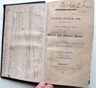
Charles Butler Ancient & Modern Music 1824 1st Edition Scarce MusicLuis Porretta Fine Arts4.3(10)See Sold PriceMar 02, 2024
1885 CIVIL WAR 1ed Famous Memoirs US Grant Sheridan Sherman 6v RARE LOT MapsSchilb Antiquarian Rare Books4.8(421)See Sold PriceMar 10, 2024
NICOLAES VISSCHER (NETHERLANDS, 1618-1709) MAP OF THE NEW WORLDThomaston Place Auction Galleries4.4(386)See Sold PriceFeb 24, 2024
CHARLES ROSNER (New York/Germany, 1894-1974), "Race of New York Yacht Club 'NY 32' Sloops"., Oil onEldred's4.7(409)See Sold PriceFeb 27, 2024
BOOKS on AMERICAN-EUROPEAN HISTORY & KING CHARLESJohn McInnis Auctioneers,LLC4.6(502)See Sold PriceFeb 24, 2024
Keith Haring - Ink on New York Map, Best Buddies, Inscribed, Signed, and DatedSapphire Auction Gallery4(67)See Sold PriceMar 02, 2024
Henri de Toulouse-Lautrec (French, 1864-1901) - Portrait of Amédée Tapie de CéleyranFreeman's | Hindman4.5(158)See Sold PriceFeb 27, 2024
War Diary of 354th Infantry - 89th Division 1919North American Artifact Auctions4.6(182)See Sold PriceApr 20, 2024
Mitchell - Map of the City of Washington (Washington, DC)Trillium Antique Prints & Rare Books4.5(30)See Sold PriceFeb 24, 2024
Francis McNally - Antique Map of Nebraska, Kansas, Dakota, Colorado & MontanaProverde Auctions4.3(3)See Sold PriceFeb 28, 2024