Sold(PENNSYLVANIA.) Desilver, Charles. A New Map o(PENNSYLVANIA.) Desilver, Charles. A New Map of the State of Pennsylvania. Hand-colored engraved folding pocket map, 385x450 mm; folds into the original 12mo format cloth case. Philadelphia, 1857 AllSee Sold Price
SoldPocket Map of Pennsylvania including New Jersey.MAP - DESILVER, Charles. A New Map of the State of Pennsylvania including New Jersey.Philadelphia: Desilver, 1860. Engraved folding pocket map, hand-colored in outline (475x740 mm). Folds inSee Sold Price
1853 MAP: COWPERTHWAITE'S NEBRASKA, KANSAS AND NEW MEXIA New Map of Nebraska, Kansas, New Mexico and Indian Territories issued by Thomas, Cowperthwaite & Co, Pennsylvania 1853-1854, published by Charles Desilver, hand colored map full sheet size: 17 incheSee Sold Price
Map of Pennsylvania by Mitchell, 1859A New Map of the state of Pennsylvania by Mitchell and published from A New Universal Atlas by Charles Desilver, Philadelphia, 1859. Map features insets of Lehigh and Schuyland Coal Regions and ViciniSee Sold Price
SoldDESILVER, CHARLES. A New Map of Nebraska, Kansas, NewDESILVER, CHARLES. A New Map of Nebraska, Kansas, New Mexico, and Indian Territories. Hand-colored lithographed map of mid-continent North America. 17½x14 inches sheet size, ample margins; sheetSee Sold Price
SoldCharles DESILVER 1856 Map of New YorkRARE 1856 Map of the "THE STATE OF NEW YORK" Compiled from the latest authorities of Philadelphia by CHARLES DESILVER. Unframed in and age appropriate condition as shown. See photos.See Sold Price
SoldRare Map, Florida, Charles DeSilver, 1856 Phila.Map Age: 1856 Maker: Charles DeSilver Description: Hand colored map reads "A New Map of Florida Published by Charles DeSilver 251 Market St. Philadelphia." Map states nautical routes throughout FloridSee Sold Price
SoldDesilver map of California, etc., 1854Title: A New Map of the State of California, the Territories of Oregon, Washington, Utah & New Mexico Author: Desilver, Charles Description: Lithographed map, hand-colored. 38x30 cm. (15x11¾") plus dSee Sold Price
SoldDesilver map of California, etc., 1856Title: A New Map of the State of California, the Territories of Oregon, Washington, Utah & New Mexico Author: Desilver, Charles Description: Lithographed map, hand-colored. 38x30 cm. (15x11¾") plus dSee Sold Price
SoldDesliver map of Nebraska, Kansas, New MexicoTitle: A New Map of Nebraska, Kansas, New Mexico and Indian Territories Author: Desilver, Charles Description: Lithographed map, hand-colored. 37.5x30.5 cm. (14¾x12") plus decorative border.The westSee Sold Price
SoldDeSILVER, CHARLES. A New Universal Atlas.DeSILVER, CHARLES. A New Universal Atlas. Color lithographed title, 72 hand-colored engraved mapsheets, lithographed double-page map, hand-colored chart of rivers and mountains [complete]. Folio, 430xSee Sold Price
SoldMitchell, A New Map of the State of Iowa.MITCHELL, Samuel Augustus (1790-1868). A New Map of the State of Iowa. Philadelphia: Charles Desilver, c. 1856. Lithographed, original hand color in full.14 x 17 ½ inches (unframed).See Sold Price
Sold"A New Map of Louisiana with its canals, roads, &"A New Map of Louisiana with its canals, roads, & distances from place to place, along the stage & steam boat routes," 1856, hand colored map, published by Charles Desilver, Phila., framed, H.- 12 in.See Sold Price
SoldMap of Louisiana, 1856 by Charles Desilver[Antique Hand-Colored Map of Louisiana], 1856, "A New Map of Louisiana with its canals, roads, & distances from place to place, along the stage & steam boat routes", by Charles Desilver, Phila., sightSee Sold Price
SoldDESILVER, CHARLES. Mitchell's New Traveller's GuideDESILVER, CHARLES. Mitchell's New Traveller's Guide Through the United States and the Canadas. 2 hand-colored lithographed maps, xxxii, 123-page booklet. 12mo format, publisher's pictorial gilt clothSee Sold Price
Sold1856 United States Map by Thomas CowerthwaitA New Map of the United States drawn by Thomas Coweperthwait, published by Charles DeSilver c.1856 Philadelphia. The print is framed in simple dark wood. The print has minor discoloration spots from aSee Sold Price
Sold[MAP]. RICHARDSON. Texas.... 1861357. [MAP]. RICHARDSON, Willard & Charles Desilver (publishers) & Heinrich Wickeland (surveyor/engineer). Richardson’s New Map of the State of Texas.... Philadelphia, 1861. Lithograph maSee Sold Price
SoldTHREE 1850'S MISSOURI & ST. LOUIS MAPSA New Map of the State of Missouri, 1856 by Charles Desilver. Color map and measures 13 3/4 x 18 1/2 inches. This is Missouri as it was 4 years prior to the Civil War. Shows Indian lands in eastern KaSee Sold Price
SoldA New Map of the State of Pennsylvania. Phila: Chas.A New Map of the State of Pennsylvania. Phila: Chas. Desilver, 1856. 14.5 x 17.5". hand-colored. Separated at some folds, light browning. Front cover detached.See Sold Price
1856 Desilver/Young Map of Pennsylvania -- A New Map ofTitle: 1856 Desilver/Young Map of Pennsylvania -- A New Map of the State of Pennsylvania Exhibiting its Internal Improvements Roads and Distances &c. by J. H. Young Cartographer: Desilver/Young Year /See Sold Price
Sold[Civil War Map][Civil War Map], Perrine, Charles O., "Perrine's New Topographical War Map of the Southern States", Indianapolis, Indiana / Buffalo, Jewett & Co., New York, 1863, printed in colors, folding case map oSee Sold Price
Sold[MAP]. Perrine’s New Topographical War Map.... 1863352. [MAP]. PERRINE, Charles O. Perrine’s New Topographical War Map of the Southern States.... [Indianapolis], 1863. Lithograph map with original outline color, major battle sites indicated in rSee Sold Price
1856 Desilver/Young Map of Pennsylvania -- A New Map ofTitle: 1856 Desilver/Young Map of Pennsylvania -- A New Map of the State of Pennsylvania Exhibiting its Internal Improvements Roads and Distances &c. by J. H. Young Cartographer: Desilver/Young Year /See Sold Price
1870 Map of New YorkTitle: 1870 Map of New York Medium: Ink on Paper Dimensions: 24"X16" Description: Map of New York state dated 1870. This map was part of the World Atlas edited and published by Charles DeSilver. ThisSee Sold Price
Ohio and Pennsylvania RR 2nd Annual Report-March 4, 1850JM Hobby Supply and Railroad Artifact Auctions4.4(126)See Sold PriceFeb 24, 2024
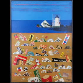
Jon Henry 1916-90 O/C Painting Titled "Orange Then Blue" 1985Rbfinearts4.4(571)See Sold PriceFeb 24, 2024
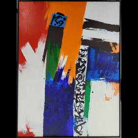
Jon Henry 1916-90 O/C Painting Titled "Spags Series #18" 1989Rbfinearts4.4(571)See Sold PriceFeb 24, 2024
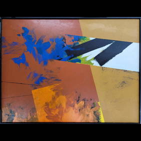
Jon Henry 1916-90 O/C Painting Titled "Crystal Beach" 1985-88Rbfinearts4.4(571)See Sold PriceFeb 24, 2024
1885 CIVIL WAR 1ed Famous Memoirs US Grant Sheridan Sherman 6v RARE LOT MapsSchilb Antiquarian Rare Books4.8(421)See Sold PriceMar 10, 2024
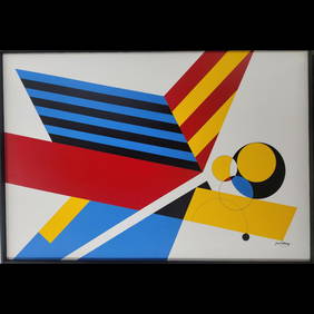
Jon Henry 1916-90 O/C Painting Titled "Prism Series #11" 1989Rbfinearts4.4(571)See Sold PriceFeb 24, 2024
Jon Henry 1916-90 O/C Painting Titled "Prism Series #41" 1989Rbfinearts4.4(571)See Sold PriceFeb 24, 2024
Jon Henry 1916-90 O/C Painting Titled "Prism Series #5" 1988Rbfinearts4.4(571)See Sold PriceFeb 24, 2024
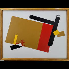
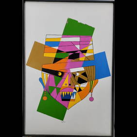
Jon Henry 1916-90 O/C Painting Titled "Mask Series #5" 1989Rbfinearts4.4(571)See Sold PriceFeb 24, 2024
Early Pennsylvania Railroad Literature - 1881 New York and Chicago Limited Timetable Brochure andRail & Road Auctions4.6(165)See Sold PriceMar 07, 2024
Keith Haring (Reading, Pennsylvania 1958 - 1990 New York) (after)Medusa Auctioneers4.3(6)See Sold PriceMar 04, 2024
1764 MAP OF COUNTRIES THIRTY MILES ROUND LONDON antique 12.5 by 15"Jasper524.5(9.8k)See Sold PriceFeb 27, 2024
Antique Pennsylvania Map Fragment incl Wellersburg and New CentervilleCordier Auctions4.4(1.5k)See Sold PriceMar 02, 2024


![[MAP]. RICHARDSON. Texas.... 1861 (1 of 6)](https://p1.liveauctioneers.com/514/38482/16500414_1_x.jpg?height=282&quality=70&version=1363615005)


![[Civil War Map] (1 of 2)](https://p1.liveauctioneers.com/268/111780/57392871_1_x.jpg?height=282&quality=70&version=1509643510)
![[MAP]. Perrine’s New Topographical War Map.... 1863 (1 of 7)](https://p1.liveauctioneers.com/514/38482/16500404_1_x.jpg?height=282&quality=70&version=1363615005)