Sold9 maps of western US. 7 publ Asher & Adams, (1872[United States: West]. 9 Maps. ++ A New Map Of Nebraska, Kansas, New Mexico And Indian Territories. From ''A New Universal Atlas,'' DeSilver, 1857. ++ A New Map Of The State Of California, The TerritoSee Sold Price
Sold9 maps: World, North America, Carribean. (1856-72[Miscellany]. 10 Maps, hand-colored, very good condition, some light toning in margins, few short tears. ++ Asher & Adams' Europe. c.1872. ++ Asher & Adams' World: On Mercator's Projection. ++ The WesSee Sold Price
1872 Asher and Adams Map of Arkansas and Western IndianTitle/Content of Map: 1872 Asher and Adams Map of Arkansas and Western Indian Territory -- Asher & Adams's Arkansas and Portion of Indian Territory Date: 1872 New York Cartographer: Asher & Adams SizeSee Sold Price
1872 Asher and Adams Map of Arkansas and Western IndianReserve Reduced! Title/Content of Map: 1872 Asher and Adams Map of Arkansas and Western Indian Territory -- Asher & Adams's Arkansas and Portion of Indian Territory Date: 1872 New York Cartographer: ASee Sold Price
Sold1872 Asher and Adams Map of Arkansas and Western IndianTitle: 1872 Asher and Adams Map of Arkansas and Western Indian Territory -- Asher & Adams's Arkansas and Portion of Indian Territory Date: 1872 New York Cartographer: Asher & Adams Size: 15.8 x 22.8 iSee Sold Price
Sold14 maps of southern states. (1856), (1872).[United States: South]. 14 lithograph maps, hand-colored, very good condition, light toning in margins. ++ 7 maps from one or more editions of ''Asher & Adams' New Statistical And Topographical Atlas.See Sold Price
SoldAsher and Adams New Statistical and Topographical AtlasAsher and Adams New Statistical Atlas 1872: Oversize atlas from 1872 by Asher and Adams. Atlas of the US. Light toning and fozing throughout. Early rare atlas in really good condition.See Sold Price
Map (from Textbook) of The Pacific Region of U.S.This map is from the Pacific region taken from a textbook of the time. (Exact year is unknown). Note there is no Nevada on this map. Utah is contiguous to California. 7.5" x 9.75". Map is matted & isSee Sold Price
Sold12 maps of northeastern states. Asher & Adams, et[United States: Mid-Atlantic]. 12 Maps. ++ 7 maps: Asher & Adams' (1) Pennsylvania And New Jersey, (2) New York And Part Of Ontario, (3) New Hampshre, Vermont, Massachusetts, Rhode Island, And ConnectSee Sold Price
Sold1872 Asher and Adams Map of Florida -- Asher & Adams'Title/Content of Map: 1872 Asher and Adams Map of Florida -- Asher & Adams' Florida Date: 1872 New York Cartographer: Asher & Adams Size: 15.8 x 22.8 in. A very nice, large map of Florida. The major cSee Sold Price
Sold1872 Asher & Adams Map of Michigan -- Asher & Adams'Title/Content of Map: 1872 Asher & Adams Map of Michigan -- Asher & Adams' Michigan Date: 1872, New York Cartographer: Asher & Adams Size: 22.2 x 16 in. This is a fantastic, very large double page mapSee Sold Price
1872 Asher and Adams Map of Illinois -- Asher & Adams'sTitle/Content of Map: 1872 Asher and Adams Map of Illinois -- Asher & Adams's Illinois Date: 1872 New York Cartographer: Asher & Adams Size: 22.2 X 15.8 in. A very nice, large map of Illinois. The majSee Sold Price
1872 Asher & Adams Map of Michigan -- Asher & Adams'Title/Content of Map: 1872 Asher & Adams Map of Michigan -- Asher & Adams' Michigan Date Printed: 1872, New York Cartographer: Asher & Adams Size: 22.2 x 16 in. This is a fantastic, very large doubleSee Sold Price
Sold1872 Asher & Adams Map of Europe -- Asher and Adams'Title/Content of Map: 1872 Asher & Adams Map of Europe -- Asher and Adams' Europe Date: 1872, New York Cartographer: Asher & Adams Size: 16 X 23 in. An attractive map of Europe showing rivers, lakes,See Sold Price
1872 Asher & Adams Map of Minnesota -- Asher & Adams'Title/Content of Map: 1872 Asher & Adams Map of Minnesota -- Asher & Adams' Minnesota Date: 1872, New York Cartographer: Asher & Adams Size: 22.4 x 16.1 in. This is a fantastic, very large double pageSee Sold Price
1872 Asher and Adams Map of Oregon -- Asher & Adams'Reserve Reduced! Title/Content of Map: 1872 Asher and Adams Map of Oregon -- Asher & Adams' Oregon Date: 1872 New York Cartographer: Asher & Adams Size: 15.8 x 22.8 in. A very nice, large map of OregoSee Sold Price
1872 Asher and Adams Map of Europe -- Asher & Adams'Reserve Reduced! Title/Content of Map: 1872 Asher and Adams Map of Europe -- Asher & Adams' Europe Date: 1872 New York Cartographer: Asher & Adams Size: 15.8 x 22.8 in. A very nice, large map of EuropSee Sold Price
maps of various states within the USATitle: Sixteen maps of cities, states and counties of the United States of America Author: ** Description: Including: 7 maps from Asher & Adams' publication, all but one are double-paged. Plus table oSee Sold Price
Sold1872 Asher & Adams Map of Minnesota -- Asher & Adams'Title/Content of Map: 1872 Asher & Adams Map of Minnesota -- Asher & Adams' Minnesota Date: 1872, New York Cartographer: Asher & Adams Size: 22.4 x 16.1 in. This is a fantastic, very large double pageSee Sold Price
1872 Asher and Adams Map of Oregon -- Asher & Adams'Title/Content of Map: 1872 Asher and Adams Map of Oregon -- Asher & Adams' Oregon Date: 1872 New York Cartographer: Asher & Adams Size: 15.8 x 22.8 in. A very nice, large map of Oregon with much of thSee Sold Price
Asher & Adams: Antique Map of Europe, 1872Map: 1872 Asher & Adams Map of Europe -- Asher and Adams' Europe Cartographer: Asher & Adams Year / Place: 1872, New York Map Dimensions: 16 X 23 Condition: Very good. Very slight toning. A small spliSee Sold Price
1872 Asher and Adams Map of Missouri -- Asher & Adams'Title/Content of Map: 1872 Asher and Adams Map of Missouri -- Asher & Adams' Missouri Date: 1872 New York Cartographer: Asher & Adams Size: 15.8 x 22.8 in. A very nice, large map of Missouri. The majoSee Sold Price
1872 Asher and Adams Map of Oregon -- Asher & Adams'Title/Content of Map: 1872 Asher and Adams Map of Oregon -- Asher & Adams' Oregon Date: 1872 New York Cartographer: Asher & Adams Size: 15.8 x 22.8 in. A very nice, large map of Oregon with much of thSee Sold Price
1872 Asher and Adams Map of Nebraska -- Asher & Adams'Reserve Reduced! Title/Content of Map: 1872 Asher and Adams Map of Nebraska -- Asher & Adams' Nebraska Date: 1872 New York Cartographer: Asher & Adams Size: 15.8 x 22.8 in. A very nice, large map of NSee Sold Price
James McGinley (NJ,NY,MD,1937-2021) oil paintingBroward Auction Gallery4.7(292)See Sold PriceMar 10, 2024
John Muirhead (UK,1863-1927) watercolor painting antiqueBroward Auction Gallery4.7(292)See Sold PriceMar 10, 2024
Dezso Czolder (Hungary,1875-1933) oil painting antiqueBroward Auction Gallery4.7(292)See Sold PriceMar 17, 2024
John Adams by Watson Sterling Silver Dinner Size Place Setting(s) 4pcBidhaus4.3(762)See Sold PriceFeb 24, 2024
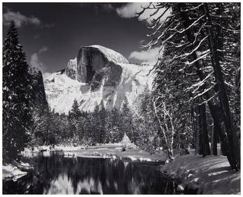
Ansel Adams (1902-1984), "Half Dome, Merced River, Winter," 1938, Gelatin silver print on paperJohn Moran Auctioneers, Inc.4.7(461)See Sold PriceFeb 27, 2024
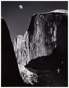
Ansel Adams (1902-1984), "Moon and Half Dome," Gelatin silver print on paper mounted to a boardJohn Moran Auctioneers, Inc.4.7(461)See Sold PriceFeb 27, 2024
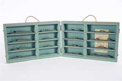
South Salem Studios, US Navy Ship Model CaseStefek's Auctioneers & Appraisers4.6(113)See Sold PriceFeb 28, 2024
CHANEL CC TIMELESS SHOPPING TOTEDejaVu Estate Sales & Auctions, LLC4.6(1.3k)See Sold PriceFeb 26, 2024