ATLAS of ANTIENT GEOGRAPHY by SAMUEL BUTLER 1843John McInnis Auctioneers,LLC4.5(505)See Sold PriceFeb 24, 2024
18TH C. ANTIQUE MAP: FRENCH & INDIAN WAR, FRAMEDThomaston Place Auction Galleries4.4(394)See Sold PriceFeb 24, 2024
Rand McNally Railroad Map Cabinet w/ 21 Railroad MapsRail & Road Auctions4.6(165)See Sold PriceMar 08, 2024
Keith Haring - Ink on New York Map, Best Buddies, Inscribed, Signed, and DatedSapphire Auction Gallery4.1(67)See Sold PriceMar 02, 2024
LATE 17TH C. FRENCH MAP OF THE NEW WORLD BY ALEXIS-HUBERT JAILLOT (1632-1712)Thomaston Place Auction Galleries4.4(394)See Sold PriceFeb 24, 2024
Central Railroad of New Jersey Map of Sandy Hook Route-ca. 1903JM Hobby Supply and Railroad Artifact Auctions4.4(127)See Sold PriceFeb 24, 2024
Lot of Six Mixed Atlas Box Cars-HO Scale-New in BoxJM Hobby Supply and Railroad Artifact Auctions4.4(127)See Sold PriceFeb 25, 2024
Rand McNally/Santa Fe Railroad Map of Iowa-1912JM Hobby Supply and Railroad Artifact Auctions4.4(127)See Sold PriceFeb 24, 2024
NICOLAES VISSCHER (NETHERLANDS, 1618-1709) MAP OF THE NEW WORLDThomaston Place Auction Galleries4.4(394)See Sold PriceFeb 24, 2024
17TH C. WORLD MAP BY NICOLAES VISSCHER (NETHERLANDS, 1618-1709)Thomaston Place Auction Galleries4.4(394)See Sold PriceFeb 24, 2024
Lot of Six Mixed Atlas Cabooses-HO Scale-New in BoxJM Hobby Supply and Railroad Artifact Auctions4.4(127)See Sold PriceFeb 25, 2024
Colton Waugh 1926 CAPE COD MapHand colored "Map of Cape Cod" published by Colton Waugh, dated 1926. Features a portrait of Myles Standish and descriptions of movements taken by the Pilgrims. Sight size is 15" x 19".See Sold Price
Unframed Coulton Waugh Hand-colored Print Map ofUnframed Coulton Waugh Hand-colored Print Map of Cape Cod, 1926, 16 x 19 1/2 in.See Sold Price
Sold1926 Map of Cape Cod by Elisabeth Leonard FramedVintage original map of Cape Cod by Melanie Elisabeth Leonard of Sandwich printed 1926. Colorful and whimsical details throughout. 24 x 34 visible. Framed to 25.75 x 36.5. Some fold lines. ExcellenSee Sold Price
Sold1926 Colorful map of Cape CodSuperb map of Cape Cod from 1926 showing the areas abundance of landmarks and points of interest. Shown are Chatham, Monomoy Island, Provincetown, Buzzard’s Bay, Cape Cod Canal etc.. Highly decSee Sold Price
SoldCOULTON WAUGH New York, 1896-1973 Pictoral map ofCOULTON WAUGH New York, 1896-1973 Pictoral map of Cape Cod, Massachusetts. Signed in plate lower left "©1930 Coulton Waugh". Depicts the Cape, showing towns and landmarks. Border with famous Cape CSee Sold Price
Vintage Cape Cod Map by Melania E. Leonard FecitCape Cod Map by Melania Elizabeth Leonard Fecit 25 x 36 inchesSee Sold Price
Cape Cod Map, Barnstable county 1880Cape Cod Map, Barnstable county 1880. Barnstable County map from 1888.. Title: Map of Cape Cod (1888). Medium: Print. Size: 16 X 23 in. Framed.See Sold Price
HENRY GANNETT, Nantucket Sound Cape Cod Map 189319 x 14 in. (sight), 26 1/4 x 20 3/4 in. (framed)See Sold Price
SoldOrleans, Cape Cod map in burl frameFramed map of the town of Orleans on Cape Cod, Massachusetts. Detailed map showing Orleans' many lakes, ponds, bays and coves as well as roadways. This is a copy from a 1902 original. Mounted into a bSee Sold Price
Cape Cod Map of BarnstableLater copy of an 1891 Walker’s map of Barnstable Massachusetts with Falmouth, Mashpee, Sandwich, Bourne, Barnstable, etc.. Also showing Buzzard’s Bay and Wareham. Nicely framed. 32â€See Sold Price
SoldCape Cod Map of BarnstableLater copy of an 1891 Walker’s map of Barnstable Massachusetts with Falmouth, Mashpee, Sandwich, Bourne, Barnstable, etc.. Also showing Buzzard’s Bay and Wareham. Nicely framed. 32” x 23 1/2”See Sold Price
Original Cape Cod map of Falmouth119 year old map by Walker with Buzzard's Bay, Bourne, Falmouth, Mashpee, Barnstable Harbor, etc... Matted and framed. 28" high x 36" wideSee Sold Price
Cape Cod Map of Falmouth & SandwichFramed map showing the Cape Cod towns of Falmouth, Barnstable, Mashpee, Sandwich, Bourne and the shores of Buzzards Bay. Fitted to a silver painted wood frame. Overall Dimensions: 34 1/2" L x 25 1/2"See Sold Price
SoldCape Cod map by Walker.Later copy of a 1891 map of Cape Cod showing Buzzards Bay, Vineyard Sound and Nantucket Sound. Communities shown include Falmouth, Mashpee, Sandwich, Osterville, Centerville and Hyannis. Showing majorSee Sold Price
SoldPR NAUTICAL WALL LAMPSPair of Vintage Wall Mount Brass Anchor Form Lamps, with Cape Cod map decorated gloss finish cardboard shades, 14" high, 8 1/4" x 9 3/4". Good condition.See Sold Price
SoldFramed Cape Cod Needlework MapItem/Description: Vintage Cap Codd (Cape Cod) Embroidered Map. 'Cap Codd' as the locals say it, and as is spelled on this 1930s piece of Americana. (Textile Art, Sampler, Cross Stitch, Antique, MassacSee Sold Price
SoldCOULTON WAUGH (1896-1973) Cape Cod Dunes, Hand coloredDescription COULTON WAUGH (1896-1973) Cape Cod Dunes, Hand colored block print Dimensions 6 1/2 x 8" image, 12 1/1 x 14" framed Artist or Maker Coulton Waugh Medium Hand colored block printSee Sold Price
SoldCape Cod Illustrated Map. 1955.Description: ARTIST: CLARA K. CHASE SIZE: 21 3/4 x 29 in./55.2 x 73.7 cm PRINTER: Atlantic Card Company, North Abbington, MA DESCRIPTION: A classic mid-'50s illustrated map of Cape Cod, Nantucket andSee Sold Price
Sold(CAPE COD: WINDMILLS, MAPS & MISCELLANEOUS) 204(CAPE COD: WINDMILLS, MAPS & MISCELLANEOUS) 204 POSTCARDS AND SOME EPHEMERA ITEMS Early To Late 20th Century Early: Wianno Pavilion & Bathing Beach, "Bringing Home A Good Catch" (exaggerated), "A FresSee Sold Price
SoldMAP, Cape Cod, Massachusetts, PaigeCape Cod, Massachusetts. Paul Paige, A Map of Cape Cod, 1940 (circa). Printed Color. This vivid pictorial map of Cape Cod is by Paul Paige of East Brewster, Massachusetts. It highlights the Cape's manSee Sold Price
SoldBoston & Cape Cod Boston Harbor Map 1915somerset chocolate giveaway, opens to 20"x16", full color by Wm. J. Finn, mintSee Sold Price
SoldHERBERT CYRUS FARNUM (Rhode Island, 1866–1926), View ofHERBERT CYRUS FARNUMRhode Island, 1866–1926View of Cape Cod scene. Signed lower right "H. Cyrus Farnum - Providence". Tilden-Thurber frame label verso.Oil on canvas, 18" x 36". Framed 25" x 42".See Sold Price
SoldMatted and Framed Map of Cape CodLater copy of a 1922 map of Barnstable County, Cape Cod. View shows the entire Cape from Bourne to Provincetown. Of special interest is the coastline near Chatham and Monomoy where major changes haveSee Sold Price
SoldEarly 20th century map of Cape CodColorful early twentieth century map of Cape Cod. All major attractions are listed. Map shows Plymouth and Barnstable County. Framed. Overall dimensions 28 inches x 39 inches.See Sold Price
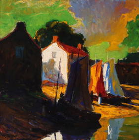
George Adomeit (American 1879-1964) CAPE COD LandscapePremier Auction Galleries4.3(338)See Sold PriceMar 09, 2024
19thc Colton Map, Comparitive Size of Lakes & IslandsConnoisseur Auctions3.9(337)See Sold PriceFeb 24, 2024
SMALL CASED MODEL OF THE TWO-MASTED "SUE B." OF CAPE COD 20th Century Case height 9.75". LengthEldred's4.7(423)See Sold PriceFeb 27, 2024
HERMES Cape Cod 23cm Quartz Belt Watch Stainless Steel Leather SilverBidhaus4.3(773)See Sold PriceFeb 26, 2024
GEORGE GUSTAV ADOMEIT (1879-1967) "CAPE COD".Amelia Jeffers, Auctioneers & Appraisers4.5(124)See Sold PriceMar 07, 2024
ODIN KAESELAU SMITH (Massachusetts, 1965-), Two Cape Cod viewsEldred's4.7(423)See Sold PriceMar 13, 2024
FOUR CAPE COD WATERCOLORS 20th Century Framed from 9" x 13" to 19" x 23".Eldred's4.7(423)See Sold PriceMar 07, 2024
1988 Cape Cod Prospects A's Ballpark Card #23- Jeff Bagwell- Beckett Graded 93 Kings Auction4.1(205)See Sold PriceFeb 24, 2024
AVON 1876 Cape Cod Collection Glass Dessert PlatesRapid Estate Liquidators and Auction Gallery4.5(1.1k)See Sold PriceFeb 25, 2024
Florida Scene and The Cape Cod Sketchbooks Done by Various ArtistsRapid Estate Liquidators and Auction Gallery4.5(1.1k)See Sold PriceFeb 25, 2024
Vintage Cape Cod Frolic One Gallon CoolerRapid Estate Liquidators and Auction Gallery4.5(1.1k)See Sold PriceFeb 26, 2024
Hermes Cape Cod Double Tour Quartz Watch Stainless Steel and Leather 29Golden Air Auctions4.3(267)See Sold PriceFeb 26, 2024
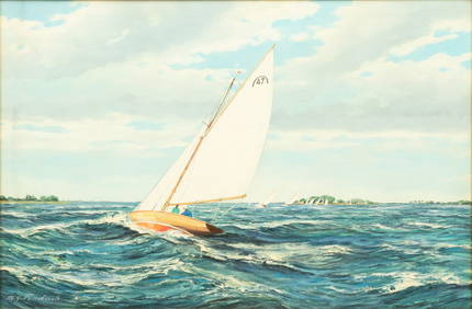
M. G. Friedrich (German/American (20th C.)) Oil on Canvas Ca. 1950, "Sailing Off Cape Cod", H 24" WDuMouchelles4.6(833)See Sold PriceMar 15, 2024