ATLAS of ANTIENT GEOGRAPHY by SAMUEL BUTLER 1843John McInnis Auctioneers,LLC4.6(502)See Sold PriceFeb 24, 2024
18TH C. ANTIQUE MAP: FRENCH & INDIAN WAR, FRAMEDThomaston Place Auction Galleries4.4(386)See Sold PriceFeb 24, 2024
Rand McNally Railroad Map Cabinet w/ 21 Railroad MapsRail & Road Auctions4.6(165)See Sold PriceMar 08, 2024
Keith Haring - Ink on New York Map, Best Buddies, Inscribed, Signed, and DatedSapphire Auction Gallery4(67)See Sold PriceMar 02, 2024
LATE 17TH C. FRENCH MAP OF THE NEW WORLD BY ALEXIS-HUBERT JAILLOT (1632-1712)Thomaston Place Auction Galleries4.4(386)See Sold PriceFeb 24, 2024
Central Railroad of New Jersey Map of Sandy Hook Route-ca. 1903JM Hobby Supply and Railroad Artifact Auctions4.4(126)See Sold PriceFeb 24, 2024
Lot of Six Mixed Atlas Box Cars-HO Scale-New in BoxJM Hobby Supply and Railroad Artifact Auctions4.4(126)See Sold PriceFeb 25, 2024
Rand McNally/Santa Fe Railroad Map of Iowa-1912JM Hobby Supply and Railroad Artifact Auctions4.4(126)See Sold PriceFeb 24, 2024
NICOLAES VISSCHER (NETHERLANDS, 1618-1709) MAP OF THE NEW WORLDThomaston Place Auction Galleries4.4(386)See Sold PriceFeb 24, 2024
17TH C. WORLD MAP BY NICOLAES VISSCHER (NETHERLANDS, 1618-1709)Thomaston Place Auction Galleries4.4(386)See Sold PriceFeb 24, 2024
Lot of Six Mixed Atlas Cabooses-HO Scale-New in BoxJM Hobby Supply and Railroad Artifact Auctions4.4(126)See Sold PriceFeb 25, 2024
SoldCharles Smith mapCharles Smith map- ''Poland''- hand0colored engraving, 1808, from 'Smith's New General Atlas Containing Distinct Maps of All the Principal Empires, Kingdoms and States throughout the World...''- paperSee Sold Price
SoldLondon.- Smith & Sons (Charles) Smith's Indicator MapNO RESERVE London.- Smith & Sons (C.) Smith's Indicator Map of London, showing from Hyde Park to Mile End, including Regents Park and part of Victoria Park with the City of London highlighted in red,See Sold Price
SoldSmith (Charles) Smith's New Map of London and StreSmith (Charles) Smith's New Map of London and Street Indicator,from Islington to Kennington Oval, and from Commercial and Surrey Docks to Hyde Park, with indicator tape on original brass mountSee Sold Price
SoldEngland & Wales.- Smith (Charles) Smith's New Map ofEngland & Wales.- Smith (Charles) Smith's New Map of the Inland Navigation of England & Wales, with details of the inland waterways, or rivers and canals, of England and Wales, engraving with originalSee Sold Price
SoldCHARLES SMITH (ENGLISH, 1768-1854) MAP OF THE WORLDCHARLES SMITH (ENGLISH, 1768-1854) MAP OF THE WORLD, hand-colored, depicting the Western and Eastern hemispheres, title centered above "The / WORLD / Engraved for Smith's Atlas", and centered below "PSee Sold Price
SoldSmith (Charles) Map Twelve Miles Round LondonSmith (Charles) Map of the Country Twelve Miles Round London,extending from Hadley to Addington, and from Northolt to Hornchurch, engraved folding map, dissected and linen-backed, with originaSee Sold Price
SoldCharles Smith 18th Century Map of Waterford HandCharles Smith 18th Century Map of Waterford Hand coloured engraving, 37.5 x 47cm.See Sold Price
SoldUK - Staffordshire 1808 Hand Col Map by Charles Smith"A New Map of the County of Stafford" Copper Engraved Map Published 1808, London. Printed for C. Smith. Dissected and linen backed. Original hand colour. Paper Size: 20.5 x 19 inch (52 x 48cm) Good coSee Sold Price
London.- Smith (Charles) Reynolds's Map of London withNO RESERVE London.- Smith (Charles, publisher) Reynolds's Map of London with the recent Improvements, lithographed map printed in colours, 605 x 880 mm. (23 3/4 x 34 3/4 in), dissected and mounted onSee Sold Price
SoldCharles W. Smith (1893 - 1987) Map of Virginia"A Historical Map of Virginia", with multiple illustrations, copyrighted 1930, some discoloration. Image: approx. 25" x 33".See Sold Price
Smith (Charles) Post Map of France & GermanySmith (Charles) New Post Map of the Northern Parts of France and Germany, Including the whole of the United Netherlands and Switzerland, showing the post stations, engraved map with original hSee Sold Price
SoldA New and Correct Map of the County of Waterford[British Isles/Ireland] A NEW AND CORRECT MAP OF THE COUNTY OF WATERFORD By C. Smith. In margin at lower right: “S. Wheatley Sculpt.” [Folding map from Charles Smith, "The antient and present statSee Sold Price
SoldSmith (Charles) New Post Map of the Northern PartsSmith (Charles) New Post Map of the Northern PartsIncluding the whole of the United Netherlands and Switzerland, showing the post stations, engraved map with original hand-colouring, 1050 x 85See Sold Price
SoldCharles Smith (18th-19th Century) British. "A New MapCharles Smith (18th-19th Century) British. "A New Map of the County of Rutland", 1801, Engraved Map, 17.25" x 19.25".See Sold Price
SoldLondon.- Smith & Sons (Charles) Illustrated Map ofLondon.- Smith & Sons (Charles) Illustrated Map of London, map of London from Hyde Park to Islington, and Whitechapel to Vauxhall, with numerous bird's-eye view vignette illustrations showing sites ofSee Sold Price
SoldVIRGINIANA - ARCHITECTURE - MAP VOLUMES, LOT OF TWVIRGINIANA - ARCHITECTURE - MAP VOLUMES, LOT OF TWO, (1). Smith, Charles W. A HISTORICAL MAP OF VIRGINIA, Richmond, VA: lithographed by A. Hoen & Co., Inc., 1930. Eight-page fold-out map. No. 237 of lSee Sold Price
SoldJOHN SMITH'S MAP OF NEW ENGLAND"NEW ENGLAND The most remarqueable parts thus named by the high and might Prince CHARLES, Prince of Great Britaine", colored engraving, made by John Smith, engraved by Simon Passaeus, and printed by JSee Sold Price
SoldA REPUBLIC OF TEXAS MAP, "Méxique," THUNOT DUVOTENAY,A REPUBLIC OF TEXAS MAP, "Méxique," THUNOT DUVOTENAY, PARIS, CIRCA 1843, hand-colored lithograph on paper, Thunot Duvotenay, French cartographer, Charles Smith, English plate engraver, a page fragmeSee Sold Price
Sold1796 Tanner Map of "Tennassee"Tennessee map, A MAP OF THE TENNASSEE [sic] GOVERNMENT FROM THE LATEST SURVEYS 1795, drawn and engraved by Benjamin Tanner, published by John Reid, Levi Wayland, and Charles Smith, New York, 1796. FroSee Sold Price
SoldH/C Map of France The Treaty of Paris, Charles SmithRare Antique Hand-Colored Map Entitled France According to The Treaty of Paris (1814) | Plate 14, Copper Plate Engraving | Cartographer : Charles Smith (1768 - 1854); Smith, Charles & Son (active 1800See Sold Price
SoldCORK MAPMap of the County of Cork from Charles Smith. History of Cork circa 1760. Framed and colouredSee Sold Price
SoldMAP OF KINSALEPanorama of Kinsale taken from Charles Smiths "The ancient and present state of Cork City" published by Wilson Dublin 1774, Framed, Smith was one of Irelands earliest topographers and country historiaSee Sold Price
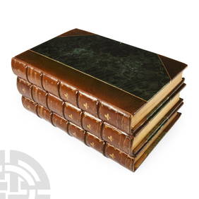
SoldAtlases.- Smith (Charles) Smith's New General Atlas, 45Atlases.- Smith (Charles) Smith's New General Atlas, engraved calligraphic title, 45 hand-coloured engraved maps, 2 double-page of Germany (numbered 19/20 & 21/22), occasional spotting, light marginalSee Sold Price
Sold(3) SMITH'S ATLAS MAPS, EGYPT, ASIA & PERSIA(lot of 3) Unframed maps from Smith's Atlas, 19th c., published by Charles Smith, London, including: (1) "Persia, Arabia, and Cabul," engraved by W.R. Gardner, sheet: approx 12.5"h, 15.75"w, (1) "EgypSee Sold Price
Richard De Ribcowsky (CA,Argentina,1880-1936) oil paintingBroward Auction Gallery4.8(277)See Sold PriceMar 31, 2024
Archaeological Books - Roach Smith & Fairholt - The Antiquities of Richborough, Reculver, and Lymne,TimeLine Auctions Ltd.4.5(183)See Sold PriceMar 06, 2024
Archaeological Books - Roach Smith - Collectanea Antiqua, etchings and notices of ancient remains,TimeLine Auctions Ltd.4.5(183)See Sold PriceMar 06, 2024
Archaeological Books - Inventorium Sepulchrale: an Account of Some AntiquitiesTimeLine Auctions Ltd.4.5(183)See Sold PriceMar 06, 2024
Archaeological Books - Roach Smith - Catalogue of the Museum of London AntiquitiesTimeLine Auctions Ltd.4.5(183)See Sold PriceMar 06, 2024
1950's Charles and Alice Smith Chalice California pottery tiki face vase. Vase has alternatingNeely Auction4.6(224)See Sold PriceFeb 25, 2024
Charles L. A. Smith California 1871-1937 Watercolor painting Landscape near LAGlobal Auctions Company4.3(36)See Sold PriceMar 03, 2024
Bugaku Mask, Emmani Men, by Deme Yasui, c. 1760The Scanlan Collection4.4(22)See Sold PriceFeb 24, 2024
1866 Philadelphia & Reading Railroad Annual PassRail & Road Auctions4.6(165)See Sold PriceMar 08, 2024
1868 and 1870 Philadelphia & Reading Railroad Annual PassesRail & Road Auctions4.6(165)See Sold PriceMar 08, 2024
These United States 1968 Folio Size HardbackNorth American Artifact Auctions4.6(182)See Sold PriceApr 20, 2024
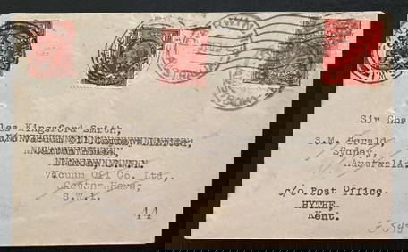
1935 Darwin Australia Experimental flight Cover To England Charles Smith Only 49Mynt Auctions4.6(680)See Sold PriceFeb 24, 2024
SEABISCUIT (2003) - Set of Seven Newspapers, Five Racing Forms, and One ProgramPropstore4.2(6)See Sold PriceMar 14, 2024
Handkerchief.- Census (The), 3 April 1881, satirical printed cotton handkerchief, 1881 & others,Forum Auctions4.3(52)See Sold PriceFeb 29, 2024
Birmingham.- Commercial map.- Smith (J. Pigott) To the Right Honourable William Earl of Dartmouth...Forum Auctions4.3(52)See Sold PriceFeb 29, 2024
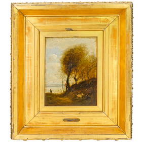
Attrib. Jean Baptiste Camille Corot (French, 1796-1875) Oil on Canvas PaintingAkiba Galleries4.7(1.7k)See Sold PriceFeb 29, 2024
NORTH AFRICA BARBARY. Parts of Tripoli (Libya) & Egypt. Tribes. SDUK 1844 mapJasper524.5(9.8k)See Sold PriceFeb 28, 2024
NORTH AFRICA BARBARY. Parts of Tripoli (Libya) & Egypt. Tribes. SDUK 1848 mapJasper524.5(9.8k)See Sold PriceFeb 28, 2024
Dr. Charles Smith (American/Louisiana, b. 1940)Neal Auction Company4.6(348)See Sold PriceMar 14, 2024