SoldCAP DE QVIERS EN CATALOGNE. Map. [Ca. 1676.][Europe/Spain]. [Beaulieu]. CAP DE QVIERS EN CATALOGNE. Double-page engraved map, handcolored, 17 ½ x 21 ½ inches, wide margins. Probably from his Le Glorieuses Conquestes de Louis Le Grand, 1676. TSee Sold Price
SoldPLAN DE GRAVELINES EN FLANDRE... Map. [Ca. 1676.][Europe/France]. Beaulieu, Sébastian de Pontault, “Engenieur du Roy”. PLAN DE GRAVELINES EN FLANDRE Assiagee Le 28 May par larmee du Roy command part Monsier le Duc Orleans et rendue a labeissaneSee Sold Price
Sold[Beaulieu]. SALSES EN ROUSSILON. Map. [Ca. 1676.][Europe/France]. [Beaulieu]. SALCES EN ROUSSILON. Double-page engraved map, handcolored, 17 ½ x 21 ½ inches, wide margins. The oval-shaped area at top center (where one would expect to find the cartSee Sold Price
SoldNicolas Sanson/Hubert Jaillot Map Europe ca. 1680Hubert Jaillot (1632-1712) and Nicolas Sanson (1600-1677), "L'Europe Divisee Suivant L'Estendue De Ses Principaux Etats, subdivises en leurs principales Provinces," Paris, ca. 1680. A lovely hand coloSee Sold Price
SoldKEULEN, Gerard van (1678-1727). Nieuwe Wassende GraadenKEULEN, Gerard van (1678-1727). Nieuwe Wassende Graaden Paskaart Vertoonende alle de Bekende Zeekusten en Landen op den geheelen Aard Boodem of Werelt. [Amsterdam, ca 1720].Engraved map of the world wSee Sold Price
Sold3 Middle & Near East Maps, plus Text Sheet & Carved Heraldic Wall Plaque, 5 items1st item: DE BESCHRYVING VAN DE REYSEN PAULI, EN VAN DE ANDERE APOSTELEN map, engraved by Daniel Stoopendaal after Bastian Stoopendaal, published by Pieter and Jacob Keur, Amsterdam, ca. 1730. CopperpSee Sold Price
Manuscript Map of the West Indies showing the Southern Coast of the Dominican Republic[West Indies, Dominican Republic] Plano dela Bahya de Ocoa Situado en la Banda del sux dela Isla Espanola... Manuscript Map in pen and ink. ca. 1780. 14 7/8" x 19 3/8" sheet. Manuscript Map of the SouSee Sold Price
SoldPietre van der Aa Map of India ca. 1700Pietre van der Aa (1659-1733) "Indien Binnen de Ganges Vertoonende de Koninkryken van Golconda, Decan, Bisnaga en Grenzen van Mogol," Leiden, ca. 1700. Hand colored map of India. This map features anSee Sold Price
Sold1798 Voyage of Bonne Esperance India w/ Maps“Voyage Par Le Cap De Bonne-Esperance A Batavia A Bantam Et Au Bengale En 1768, 69, 70, Et 71”, by J. S. Stavorinus, printed at Paris at Chez H.J. Jansen, 1798, Half and full-title, [2], 3-434, ErSee Sold Price
Nouvelle Carte des Etats du Grand Duc de Moscovie enNouvelle Carte des Etats du Grand Duc de Moscovie en Europe. Partie Sertentrionale. Kupferstichkarte. Amsterdam, H. Chatelain, um 1720. Plattengröße ca. 36,5 x 48,4 cm. Copper engr. map. - CentrefolSee Sold Price
SoldDiderot and de Vaugondy Map of California ca. 177Denis Diderot (1713-1784) and Didier Robert de Vaugondy (ca. 1723–1786), "Carte De La Californie Suivant I. la Carte manuscrite de l'Amerique de Mathieu Neron Pecci olen dresee a Florence en 16See Sold Price
Sold[JAILLOT] MAP OF HUNGARY & SURROUNDINGS'Le Royaume De Hongrie Et Les Estats qui en ont este sujets....La Partie Septentrionale De La Turquie en Europe, by Alexis-Hubert Jaillot (ca. 1632-1712) and Guillaume Sanson (1633-1703), engraving wiSee Sold Price
SoldGeorges Louis Rouge Plan of Paris Map 1765Georges-Louis Le Rouge (ca. 1712-1780), "Plan de Paris et de ses faubourgs en l'état qu'il étoit en 1765." This attractive map features the city of Paris along with points of interest. DimensionSee Sold Price
SoldRARE 18TH C. FRENCH MAP OF SCANDINAVIANicolas Sanson, "La Scandinavie, et les Environs, ou sont Les Royaumes de Suede, de Danemark et de Norwege divises en leurs principales Provinces": published by Pierre Schenk, Amsterdam, ca. 1700. CopSee Sold Price
SoldSanson's map of Southern Asia 1679Title: Partie Meridionale de l'Inde en deux Presqu'Isles l'une de çà et l'aitre de là Gange Author: Sanson, Nicolas Description: Copper-engraved map, hand-colored in outline. 37.7x52.5 cm. (14¾x20See Sold Price
Le Cercle de Westphalie divisé en tous ses Estats etLe Cercle de Westphalie divisé en tous ses Estats et Souverainetés ... Kol. Kupferstichkarte von Cordier nach Sanson. Paris, Dezauche, (1789). Plattengröße ca. 65 x 47 cm. Col. copper engr. map. -See Sold Price
SoldLETH, Hendrik de. Nieuwe geographische en historiscAmsterdam, H. de Leth, (ca. 1740). Agenda 4to (ca. 200 x 75 mm). Folding engr. title-page with eight coats of arms, and 53 folding engr. plates of maps and plans, mostly in contemp. handcolouring. (52See Sold Price
SoldPlano del puerto de la Ysla de Roatán...Plano del puerto de la Ysla de Roatán cituado en la parte del S. y E. de ella. [HONDURAS]. [Cadiz: Escuela de Navegación, ca 1793]. Single sheet (15 x 21 inches; 13 2/8 x 19 inches to the neat line)See Sold Price
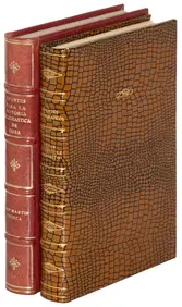
[KENNEMERLAND] – BROUËRIUS VAN NIDEK, M. Het, Te Amsterdam, By Andries en Hendrik de Leth [..], [ca. 1730]. 1 TEXT-VOLUME (consisting of 2 parts: [6],24 & 18 pp. 2 ident. engraved frontispieces, engraved printer’s device on title, 1 engraSee Sold Price
Carte de la Guinée West Africa Gulf of Guinea. SANTINITITLE/CONTENT OF MAP: 'Carte de la Guinée contenant les Isles du Cap Verd, le Senegal, la Côte de Gunée proprement dite, les Royaumes de Loango, Congo, Angola et Benguela, avec les Pays voisiSee Sold Price
SoldMap Caart van de Rivieren Coretyn 1770Map: Caart Van de Rivieren Coretyn, Copename en Sarameca Maker: Jacobus van der Schley Technique: Hand colored Date: ca. 1770 Size: 10 x 18 inches Jakob van der Schley, or Jakob van Schley, (1715 - 17See Sold Price
Sold[Map] Large Wall-Map of France, 1791Belleyme, Pierre de. "Carte de la France Divisee en 83 Departements et subdivisee… Presentee A L'Assemblee Nationale et au Roi. Par de Belleyme … 1791." Paris: Belleyme, ca. 1791. Hand-colored, onSee Sold Price
1765 MAP BY ISAAK TIRIONKaart van de onderdoningschappen van Mexico en Nieuw Granada in de Spaansche West-Indien.Scale ca. 1:1,650,000. Hand colored. Relief shown pictorially. Shows southern United States, Mexico, Central AmSee Sold Price
SoldA Map by Gerardus en Leonardus ValkBelgica, by Gerardus en Leonardus Valk, Amsterdam, ca. 1710, 60 x 50 cm.See Sold Price
LARGE LATE 17TH C. DUTCH CHART OF CANADA, GREAT LAKES, NEW FRANCE, LABRADOR, HUDSON BAY, BY PIERREThomaston Place Auction Galleries4.4(386)See Sold PriceFeb 24, 2024
EARLY 18TH C. DUTCH CHART OF PACIFIC OCEAN BY FREDERIK DE WIT (1629-1706) WITH CALIFORNIA AS ANThomaston Place Auction Galleries4.4(386)See Sold PriceFeb 24, 2024
LATE 16TH C. MAP OF SCOTLAND BY MERCATOR, FRAMEDThomaston Place Auction Galleries4.4(386)See Sold PriceFeb 24, 2024
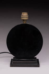
Jacques ADNET (dans le gout): Pied de lampe en bakélite en forme d'un disque noir. H 23 cm.Valoir Pousse-Cornet4.3(4)See Sold PriceFeb 24, 2024
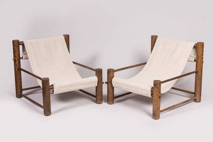
Charlotte PERRIAND (dans le gout de): Paire de fauteuils en rondins de bois tendu d'un tissu àValoir Pousse-Cornet4.3(4)See Sold PriceFeb 24, 2024
Groupe MEMPHIS (dans le goût de) : Lustre composé de disques en bois coloré. H : env. 70 - D : 55Valoir Pousse-Cornet4.3(4)See Sold PriceFeb 24, 2024
[SHEET MUSIC]. [SIDESHOWS]. Saprelotte et Sacredie!... Cavr...Potter & Potter Auctions4.6(539)See Sold PriceMar 07, 2024
[MAPS]. DUFOUR, Auguste-Henri (1795-1865). Bound Volume of ...Potter & Potter Auctions4.6(539)See Sold PriceMar 07, 2024
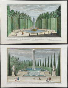
Demortain - 4 Fountain & Garden EngravingsTrillium Antique Prints & Rare Books4.5(30)See Sold PriceFeb 24, 2024
Linocier's L'Histoire des plantes - Volume with Numerous In Text Natural History Illustrations toTrillium Antique Prints & Rare Books4.5(30)See Sold PriceFeb 24, 2024
Map: An 18thC engraved and hand coloured map of North America and South America, titled DeClaydon Auctioneers Ltd4.3(125)See Sold PriceFeb 26, 2024
1738 BIBLE in DUTCH ILLUSTRATED w/ MAPS MASSIVE FOLIO in DUTCH antique BIBLIAJasper524.5(9.8k)See Sold PriceFeb 27, 2024
Coste Orientale d’Afrique…' South Africa. Mozambique channel. BELLIN 1746 mapJasper524.5(9.8k)See Sold PriceFeb 28, 2024
Coste Occidentale d’Afrique…' Namibia South Africa Angola coast BELLIN 1746 mapJasper524.5(9.8k)See Sold PriceFeb 28, 2024
Elisabeth Garouste (France, née en 1949) & Mattia Bonetti (Suisse, né en 1953). Paire ...Bonhams4.1(305)See Sold PriceMay 21, 2024
![CAP DE QVIERS EN CATALOGNE. Map. [Ca. 1676.] First Image](https://p1.liveauctioneers.com/179/54294/26374870_1_x.jpg?height=282&quality=95&version=1398371595&width=282)
![CAP DE QVIERS EN CATALOGNE. Map. [Ca. 1676.] (1 of 3)](https://p1.liveauctioneers.com/179/54294/26374870_1_x.jpg?height=282&quality=70&version=1398371595)
![CAP DE QVIERS EN CATALOGNE. Map. [Ca. 1676.] First Image](https://p1.liveauctioneers.com/179/54294/26374870_1_x.jpg?height=282&quality=1&version=1398371595&width=282)
![PLAN DE GRAVELINES EN FLANDRE... Map. [Ca. 1676.] (1 of 6)](https://p1.liveauctioneers.com/179/54294/26374856_1_x.jpg?height=282&quality=70&version=1398371595)
![[Beaulieu]. SALSES EN ROUSSILON. Map. [Ca. 1676.] (1 of 3)](https://p1.liveauctioneers.com/179/54294/26374854_1_x.jpg?height=282&quality=70&version=1398371595)


![[JAILLOT] MAP OF HUNGARY & SURROUNDINGS (1 of 8)](https://p1.liveauctioneers.com/522/124271/63207925_1_x.jpg?height=282&quality=70&version=1530290718)


![[KENNEMERLAND] – BROUËRIUS VAN NIDEK, M. Het (1 of 5)](https://p1.liveauctioneers.com/7040/154798/78157452_1_x.jpg?height=282&quality=70&version=1573578708)


![[Map] Large Wall-Map of France, 1791 (1 of 9)](https://p1.liveauctioneers.com/3532/146911/74242402_1_x.jpg?height=282&quality=70&version=1564368564)


![[SHEET MUSIC]. [SIDESHOWS]. Saprelotte et Sacredie!... Cavr... (1 of 1)](https://p1.liveauctioneers.com/928/318880/171361188_1_x.jpg?height=282&quality=70&version=1707501302)
![[MAPS]. DUFOUR, Auguste-Henri (1795-1865). Bound Volume of ... (1 of 2)](https://p1.liveauctioneers.com/928/318880/171361279_1_x.jpg?height=282&quality=70&version=1707501302)