ATLAS of ANTIENT GEOGRAPHY by SAMUEL BUTLER 1843John McInnis Auctioneers,LLC4.6(502)See Sold PriceFeb 24, 2024
18TH C. ANTIQUE MAP: FRENCH & INDIAN WAR, FRAMEDThomaston Place Auction Galleries4.4(386)See Sold PriceFeb 24, 2024
Rand McNally Railroad Map Cabinet w/ 21 Railroad MapsRail & Road Auctions4.6(165)See Sold PriceMar 08, 2024
Keith Haring - Ink on New York Map, Best Buddies, Inscribed, Signed, and DatedSapphire Auction Gallery4(67)See Sold PriceMar 02, 2024
LATE 17TH C. FRENCH MAP OF THE NEW WORLD BY ALEXIS-HUBERT JAILLOT (1632-1712)Thomaston Place Auction Galleries4.4(386)See Sold PriceFeb 24, 2024
Central Railroad of New Jersey Map of Sandy Hook Route-ca. 1903JM Hobby Supply and Railroad Artifact Auctions4.4(126)See Sold PriceFeb 24, 2024
Lot of Six Mixed Atlas Box Cars-HO Scale-New in BoxJM Hobby Supply and Railroad Artifact Auctions4.4(126)See Sold PriceFeb 25, 2024
Rand McNally/Santa Fe Railroad Map of Iowa-1912JM Hobby Supply and Railroad Artifact Auctions4.4(126)See Sold PriceFeb 24, 2024
NICOLAES VISSCHER (NETHERLANDS, 1618-1709) MAP OF THE NEW WORLDThomaston Place Auction Galleries4.4(386)See Sold PriceFeb 24, 2024
17TH C. WORLD MAP BY NICOLAES VISSCHER (NETHERLANDS, 1618-1709)Thomaston Place Auction Galleries4.4(386)See Sold PriceFeb 24, 2024
Lot of Six Mixed Atlas Cabooses-HO Scale-New in BoxJM Hobby Supply and Railroad Artifact Auctions4.4(126)See Sold PriceFeb 25, 2024
Coste Orientale d'Afrique' South Africa Mozambique.TITLE OF THE MAP: 'Carte de la Coste Orientale d'Afrique depuis le Cap de Bonne Esperance, jusqu'au Cap del Gada. Tirée de la Carte Francoise de l'Océan Oriental Publiée par ordre de Mgr. le ComteSee Sold Price
SoldMAP, Eastern Africa, BellinEastern Africa. Jacques Nicolas Bellin, Carte de la Coste Orientale d'Afrique Depuis le XIIIe. Degre de Latitude Meridionale Jusqu'au XVIe. Degre de Latitude Septentrionale..., 1740 (dated). Hand ColoSee Sold Price
MAP - Eastern Africa. BellinEastern Africa. Jacques Nicolas Bellin, Carte de la Coste Orientale d'Afrique Depuis le XIIIe. Degre de Latitude Meridionale Jusqu'au XVIe. Degre de Latitude Septentrionale..., 1740 (dated). Hand ColoSee Sold Price
Sold1740 Carte de la Coste Orientale D'Afrique1740 Carte de la Coste Orientale D'Afrique by Bellin, hand colored map of the Oriental Coast of Africa, 10 1/4" x 8 1/2"See Sold Price
Coste Occidentale d'Afrique' South Africa Namibia.TITLE OF THE MAP: 'Coste Occidentale D'Afrique depuis le XIe dégré de latitude méridionale jusqu'au Cape de Bonne Espérance Tirée de la Carte de l'Océan méridional publiée par ordre de Mgr. leSee Sold Price
Sold5 Maps: Africa. Bonne, Moll, Thompson, 2 others.[Africa] 5 Maps. ++ CARTE DE LA COSTE ORIENTALE d’AFRIQUE. [c. 1757]. Hand-colored outline. 9 ¾” x 7 5/8”. Upper edge has 2 narrow tape remnants, near fine. ++ LE ROYAUME d’adel: Les Cotes d�See Sold Price
Sold8 maps by De Fer, 1739-1740. Africa, Middle East.[Africa/Mideast] 8 maps by De Fer, 1739-1740. Most images approx. 8 x 10 in. Double-page. Includes: ++ Carte de la Coste d’Arabie Et Golfe de Perse… ++ Carte de la Coste Orientale d’Afrique DepuSee Sold Price
1746 Bellin Map of Part of Coastal Mauritania -- CarteTitle: 1746 Bellin Map of Part of Coastal Mauritania -- Carte de la Coste Occidentale d'Afrique Depuis le Cap Blanc Jufqu'a Tatit Date: 1746, Paris Cartographer: J Bellin Size: 9 X 6.1 in. AdditionalSee Sold Price
1746 Bellin Map of Part of Coastal Mauritania -- CarteReserve Reduced! Title/Content of Map: 1746 Bellin Map of Part of Coastal Mauritania -- Carte de la Coste Occidentale d'Afrique Depuis le Cap Blanc Jufqu'a Tatit Date: 1746, Paris Cartographer: J BellSee Sold Price
1746 Bellin Map of Part of Coastal Mauritania -- CarteTitle/Content of Map: 1746 Bellin Map of Part of Coastal Mauritania -- Carte de la Coste Occidentale d'Afrique Depuis le Cap Blanc Jufqu'a Tatit Date: 1746, Paris Cartographer: J Bellin Size: 9 X 6.1See Sold Price
1746 Bellin Map of Part of Coastal Mauritania -- CarteTitle/Content of Map: 1746 Bellin Map of Part of Coastal Mauritania -- Carte de la Coste Occidentale d'Afrique Depuis le Cap Blanc Jufqu'a Tatit Date: 1746, Paris Cartographer: J Bellin Size: 9 X 6.1See Sold Price
1746 Bellin Map of Part of Coastal Mauritania -- CarteTitle: 1746 Bellin Map of Part of Coastal Mauritania -- Carte de la Coste Occidentale d'Afrique Depuis le Cap Blanc Jufqu'a Tatit Cartographer: J Bellin Year / Place: 1746, Paris Map Dimension (in.):See Sold Price
1746 Bellin Map of Part of Coastal Mauritania -- CarteTitle/Content of Map: 1746 Bellin Map of Part of Coastal Mauritania -- Carte de la Coste Occidentale d'Afrique Depuis le Cap Blanc Jufqu'a Tatit Date: 1746, Paris Cartographer: J Bellin Size: 9 X 6.1See Sold Price
MAP, Northwestern Africa, BellinNorthwestern Africa. Jacques Nicolas Bellin, Carte Reduite des Costes Occidentales d'Afrique Seconde Feuille Depuis le Cap Bojador Jusqu'a la Riviere de Sierra Leona Pour le Service des Vaisseaux du RSee Sold Price
MAPS, Central & Southern Africa, BellinCentral & Southern Africa. Jacques Nicolas Bellin, [Lot of 2] Coste Occidentale d'Afrique, Depuis le XIe. Degre de Latitude Meridionale, Jusqu'au Cap de Bonne Esperance... [and] Cite de Loango, TireeSee Sold Price
SoldBellin Map of West North Africa & Canary Islands, 17501750 Bellin Map of Western North Africa and Canary Islands -- Coste Occidentale D'Afrique. This is Bellin's map of the northwestern coast of Africa. It covers from the Strait of Gibraltar to just beloSee Sold Price
Bellin: Map of West Coast of Africa, 1739Map: Coste Occidentale d’Afrique Depuis le XIe degre Cartographer: Bellin Place & Date: Paris / 1739/1760 Size: 10 1/4" x 9 1/2" Bellin's map of the west coast of Africa, from Benguela (Angola) to tSee Sold Price
BELLIN, Jacques-Nicolas (1703-1772). Group of 5 AfBELLIN, Jacques-Nicolas (1703-1772). Group of 5 Africa Maps.Coste Occidentale D'Afrique - Depuis le Detroit . Paris, 1738. Engraved map (255 x 360mm); Together with 4 other maps by Bellin of tSee Sold Price
Bellin: Map of West Africa/Angola to Cape of Good HopeCoste Occidentale d’Afrique Depuis le XIe degre Bellin's map of the west coast of Africa, from Benguela (Angola) to the Cape of Good Hope, from the atlas of Prevost d'Exiles' influential collectionSee Sold Price
Bellin: Antique Map of West Coast of Africa, 1759Title/Content of Map: Carte de la Coste Occidentale d'Afrique Depuis le Cap Blanc Jusqu'a a Tanit Date Printed: 1759 Cartographer: Bellin, Jacques Nicolas Size (inches): 6 x 9 Outline coloring. SmallSee Sold Price
SoldBellin: Antique Map of the West Coast of Africa, 1738Map: Coste Occidentale d’Afrique Depuis le Detroit de Gibraltar Cartographer: Bellin Place & Date: Paris / 1738/1760 Size: 7 3/4" x 9 5/8" Condition: b&w; overall age toning; minor spotting in wideSee Sold Price
Bellin: Antique Chart Map of West Africa, 1759Map: Carte de la Coste Occidentale d'Afrique Depuis le Cap Blanc Jusqu'a a Tanit Date Printed: 1759 Cartographer: Bellin, Jacques Nicolas Size: 6 x 9 Condition: Very good Small chart of the African coSee Sold Price
Bellin: Antique Map of West Coast of Africa, 1739Map: Coste Occidentale d’Afrique Depuis le XIe degre Cartographer: Bellin Place & Date: Paris / 1739/1760 Size: 10 1/4" x 9 1/2" Condition: b&w; a light impression; margins extended with contemporarSee Sold Price
Sold[Bonne (R)] Coste Occidentale d'Afrique[Bonne (R)] Coste Occidentale d'Afriqueshowing part of the west coast, the east coast and the south-east coast of Africa, with decorative cartouches, 3 engraved maps with original hand-colouriSee Sold Price
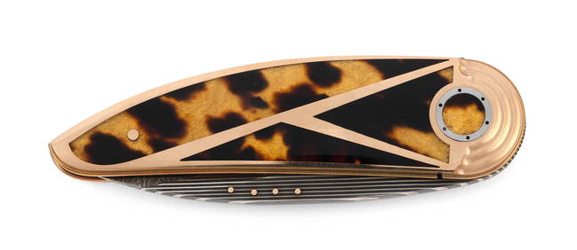
OWEN WOOD ART DECO-STYLE CRESCENT FOLDING KNIFE South Africa/Colorado/Texas, Contemporary Length 3".Eldred's4.7(409)See Sold PriceFeb 28, 2024
2 African Ashanti Combs on Stands, Ghana, Mid 20th C.Material Culture4.6(765)See Sold PriceFeb 29, 2024
[MOTORCYCLES]. Two Photo Albums of Snapshots of a South Afr...Potter & Potter Auctions4.6(539)See Sold PriceMar 07, 2024
Carey, pub. 1796 - Map of GeorgiaTrillium Antique Prints & Rare Books4.5(30)See Sold PriceFeb 24, 2024
Carey, pub. 1796 - Map of The State of South CarolinaTrillium Antique Prints & Rare Books4.5(30)See Sold PriceFeb 24, 2024
Carey, pub. 1796 - Map of KentuckyTrillium Antique Prints & Rare Books4.5(30)See Sold PriceFeb 24, 2024
Carey, pub. 1796 - Map of the Tennassee State formerly part of North Carolina (Tennessee)Trillium Antique Prints & Rare Books4.5(30)See Sold PriceFeb 24, 2024
Coste Occidentale d’Afrique…' Arguin Bay Cap Blanc Mauritania. BELLIN 1746 mapJasper524.5(9.8k)See Sold PriceFeb 28, 2024
Partie de la Coste d'Afrique depuis Tanit…' Southern Mauritania BELLIN 1746 mapJasper524.5(9.8k)See Sold PriceFeb 28, 2024
Carte du Canal de Mosambique…. Madagascar Bonne Esperance. BONNE 1780 mapJasper524.5(9.8k)See Sold PriceFeb 28, 2024
Coste Orientale d’Afrique…' South Africa. Mozambique channel. BELLIN 1746 mapJasper524.5(9.8k)See Sold PriceFeb 28, 2024
Coste Occidentale d’Afrique…' West Africa. Gulf of Guinea. BELLIN 1746 mapJasper524.5(9.8k)See Sold PriceFeb 28, 2024
Coste d’Afrique…' Guinea-Bissau & Bissagos archipelago. BELLIN 1746 old mapJasper524.5(9.8k)See Sold PriceFeb 28, 2024
Coste Orientale d’Afrique'. South Africa Mozambique BELLIN/SCHLEY 1747 mapJasper524.5(9.8k)See Sold PriceFeb 28, 2024
Coste Orientale d’Afrique…' East Africa Kenya Tanzania Somalia. BELLIN 1746 mapJasper524.5(9.8k)See Sold PriceFeb 28, 2024
Coste Occidentale d’Afrique…' Namibia South Africa Angola coast BELLIN 1746 mapJasper524.5(9.8k)See Sold PriceFeb 28, 2024
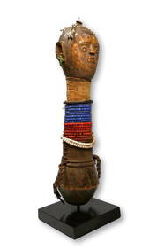
Rare Antique Sotho Wooden Doll Ex Sam Hilu CollectionTRIBAL GATHERINGS4.7(290)See Sold PriceMar 02, 2024
A Zulu Serving Tray or Meat Platter Ex Becker CollectionTRIBAL GATHERINGS4.7(290)See Sold PriceMar 02, 2024


![[Bonne (R)] Coste Occidentale d'Afrique (1 of 1)](https://p1.liveauctioneers.com/410/8611/1592174_1_x.jpg?height=282&quality=70&version=1136842603)
![[MOTORCYCLES]. Two Photo Albums of Snapshots of a South Afr... (1 of 6)](https://p1.liveauctioneers.com/928/318880/171361283_1_x.jpg?height=282&quality=70&version=1707501302)