ATLAS of ANTIENT GEOGRAPHY by SAMUEL BUTLER 1843John McInnis Auctioneers,LLC4.5(505)See Sold PriceFeb 24, 2024
18TH C. ANTIQUE MAP: FRENCH & INDIAN WAR, FRAMEDThomaston Place Auction Galleries4.4(393)See Sold PriceFeb 24, 2024
Rand McNally Railroad Map Cabinet w/ 21 Railroad MapsRail & Road Auctions4.6(165)See Sold PriceMar 08, 2024
Keith Haring - Ink on New York Map, Best Buddies, Inscribed, Signed, and DatedSapphire Auction Gallery4(67)See Sold PriceMar 02, 2024
LATE 17TH C. FRENCH MAP OF THE NEW WORLD BY ALEXIS-HUBERT JAILLOT (1632-1712)Thomaston Place Auction Galleries4.4(393)See Sold PriceFeb 24, 2024
Central Railroad of New Jersey Map of Sandy Hook Route-ca. 1903JM Hobby Supply and Railroad Artifact Auctions4.4(127)See Sold PriceFeb 24, 2024
Lot of Six Mixed Atlas Box Cars-HO Scale-New in BoxJM Hobby Supply and Railroad Artifact Auctions4.4(127)See Sold PriceFeb 25, 2024
Rand McNally/Santa Fe Railroad Map of Iowa-1912JM Hobby Supply and Railroad Artifact Auctions4.4(127)See Sold PriceFeb 24, 2024
NICOLAES VISSCHER (NETHERLANDS, 1618-1709) MAP OF THE NEW WORLDThomaston Place Auction Galleries4.4(393)See Sold PriceFeb 24, 2024
17TH C. WORLD MAP BY NICOLAES VISSCHER (NETHERLANDS, 1618-1709)Thomaston Place Auction Galleries4.4(393)See Sold PriceFeb 24, 2024
Lot of Six Mixed Atlas Cabooses-HO Scale-New in BoxJM Hobby Supply and Railroad Artifact Auctions4.4(127)See Sold PriceFeb 25, 2024
SoldBlaeu French Regional Map, 17th C.Les Souverainetez de Sedan et de Raucourt et la prevosté de Doncheri. Willem Janszoon Blaeu (1571-1638). Joan Blaeu (1596-1673). Amsterdam: Mid 17th Century. Hand-colored engraving19 3/4 x 24 inchesSee Sold Price
SoldANTIQUE SPANISH MAP, JOHANNES BLAEU, 17TH C."Episcopatus Tervelensis et Albaracinensis" a regional map of Spain, 17th c., Johannes Blaeu (Dutch, 1596-1673), hand colored figural cartouche at lower left, center fold mark, tears at edges, sight wSee Sold Price
SoldAntique Copy of Willem Blaeu World Map,Antique Copy of Willem Blaeu World Map, 19th c. reprint of 17th c. original, paper watermarked by French manufacturer Anson & Montgolfier. Appears to be hand-colored, but not examined out of frame. DOSee Sold Price
SoldABRAHAM ORTELIUS 17TH C BURGUNDY FRANCE MAPABRAHAM ORTELIUS 17TH C BURGUNDY FRANCE MAP Hand colored decorative regional map of France, early 17th C., centered on Besancon, Poligny, Quingey and St Anne. Includes a number of famous wine regions.See Sold Price
SoldBLAEU ENGRAVING MAP OF THE NETHERLANDS, 17TH C.Unframed map, engraving on paper, "Frisia Occidentalis," cartographers Adriano Metius and Gerardo Freitag, published by Willem Blaeu (Dutch, 1571-1638), reverse with text, sheet: approx 19.75"h, 23"wSee Sold Price
SoldWillem Blaeu 17th C. Map of FranceAuthor: Willem Blaeu Hand Colored Published in Amsterdam c.1635. "Les Souverainetez de Sedan et de Raucourt, et la Prevoste de Doncheri."See Sold Price
SoldFrance Antique Map & View, 17th C.Descriptio Veromanduorum, Antique map, Blaeu, Amsterdam, mid 17th C. W/ view Mommedy on 2 separate sheets, engraving by Israel Silvestre, 1669. 19 1/2" x 26 1/4".See Sold Price
SoldGroup of Three Antique Maps, consisting of JohannesGroup of Three Antique Maps, consisting of Johannes Blaeu (1599-1673), "Map of Peru," 17th c; Jean Baptiste d'Anville (1699-1763), "Aegyptus Antiquae," 1765; and Jean Baptiste D'Anville (1699-1763), "See Sold Price
SoldEight Antique Maps by BlaeuEight Antique Maps by Blaeu , 17th c., hand-colored engravings, incl. Holland, Frankfort, Austria, Umbria, and others, sheets 19 1/2 in. x 23 in Provenance: Property deaccessioned from the Louisiana SSee Sold Price
Sold17TH C. FRENCH COLORED MAP, LE ROYAUME DE FRANCEH. Jaillot, 1692, Paris impression 23 by 35.5 in.; framed under glass 25 by 37" Glued on reverse to backing, the printed Table Alphabetique de tous les Mots......See Sold Price
SoldJ. Blaeu, Antique 17th C. Map of NavarraHand colored engraving. Framed. Approx. 17" H x 20" W w/o frame, 24" H x 27" W framed. From an estate on the Upper West Side. (4050) Some creasing due to age.See Sold Price
ANTIQUE 17TH C MAP CASTILIA W. BLAEUAntique map of Castilia by W. Blaeu. Title: Utriusquae Castiliae Nova Descriptio. By: Willem Jansz. (also written Guilielmus Janssonius) -- Willem Janszoon Blaeu. Date of the first edition/map first pSee Sold Price
Sold17TH C, MAP OF BERMUDA, WILLEM BLAEU, FRAMEDWillem Blaeu (Dutch, 1751-1638). "Bermuda (Mappa Aestivarum Insularum Alias Barmudas)", -1630. Hand colored engraving. Elaborately framed. Approx. 28.75" x 33.75" (frame), 15.75" x 20.75" (sight)See Sold Price
SoldFRAMED 17TH C. DUTCH MAP BY JOAN BLAEU (1596-1673)"Territorii Bergensis Accvratissima Descriptio", from "Atlas Maior Sive Cosmographia Blaviana, Qua Solvm, Salvm, Coelvm, Accvratissime Describvntvr." Koeman B1 56; van der Krogt 2:601-3 (first volumeSee Sold Price
Sold17th c. J. Blaeu (?) Engraved Map of Asia Minor17th c. J. Blaeu (?), 1596 - 1673 copper engraved map of Asia Minor, hand colored accents including land boarders, cities and sea serpents, hand colored figures and ships, highlighted with gold indicaSee Sold Price
Sold(2) 17TH C. LATIN AMERICAN MAPS, WILLIEM BLAEUGUIANA fiue AMAZONUM REGIO, 15 by 19.75 in. (sight); the other NOVUS BRASILIA TYPUS, 15 by 20 in. both AMSTELODAMI, GUILJELMUS BLAEUW excudit both matted and framed under glassSee Sold Price
Sold17TH C, MAP OF NEW ENGLAND, WILLEM BLAEU. FRAMEDWillem Blaeu (Dutch, 1751-1638). "Nova Belgica et Anglia Nova (Map of New Belgium and New England)" -1638, hand colored engraving. Elaborately framed. Approx. 28.5" X 33" (frame), 15.5" x 20" (sight)See Sold Price
SoldAntique 17th C Blaeu Tabula Magellanica MapAntique 17th Century Willem Blaeu (Dutch, 1571-1638) Hand Colored Tabula Magellanica Map. Map measures 16 inches high x 21 inches wide. Frame measures 17 inches high x 22.5 inches wide.See Sold Price
SoldWillem Blaeu Map, "Hiberina Regnum Vulgo Ireland",Willem Blaeu Map, "Hiberina Regnum Vulgo Ireland", Amsterdam, c. 1650, a magnificent example of 17th c. Dutch cartography showing the Emerald Isle divided into counties and having English place names,See Sold Price
SoldJ. & W. map, 17th c,J. & W. Blaeu- ''Herefordia Comitatus- Herfordshire''- hand-colored engraving, 1664, Amsterdam, decorative cartouche, humerous coat-of-arms,laid down, some staining and foxing. 16 x 19 3/4''hSee Sold Price
Sold[Blaeu (Willem)] partie du Comte de Charolois[Blaeu (Willem)] Les environs de L'Estang de Longpendu, Comprenant une grande partie du Comte de Charolois,French regional map with figurative title cartouche, engraved map by Jean van Damme,See Sold Price
SoldThree 17th century European mapstwo French regional maps with one border, [Descriptio Veromanduorum Auctore Ioanne Suthoni Gallice Vermandois] and [Govvernement de la Cappele par P. petit Bourbon] from [Theatrum Orbis Terrarum, siveSee Sold Price
Two maps of China, Blaeu, Amsterdam, 17th C.Two maps of China, Blaeu, Amsterdam, 17th C. Dim.: 63,5 x 52 cm (incl. the frame)Dim.: 51 x 40 cm (excl. the frame) Dim.: 65,5 x 65,5 cm (incl. the frame)Dim.: 51,5 x 41 cm (excl. the frame)See Sold Price
SoldFramed Colored Engraved 17th C. World Map"Nova Totius Terrarum Sive Novi Orbis Tabula" Framed Colored Engraved 17th C. World Map by Willem Janszoon Blaeu - This interesting piece is an early world map created by Willem Janszoon Blaeu. The maSee Sold Price
LARGE LATE 17TH C. DUTCH CHART OF CANADA, GREAT LAKES, NEW FRANCE, LABRADOR, HUDSON BAY, BY PIERREThomaston Place Auction Galleries4.4(393)See Sold PriceFeb 24, 2024
17TH C. WORLD MAP BY NICOLAES VISSCHER (NETHERLANDS, 1618-1709)Thomaston Place Auction Galleries4.4(393)See Sold PriceFeb 24, 2024
LATE 17TH C. FRENCH MAP OF THE NEW WORLD BY ALEXIS-HUBERT JAILLOT (1632-1712)Thomaston Place Auction Galleries4.4(393)See Sold PriceFeb 24, 2024
17TH C. ANTIQUE MAP SIEGE OF LA ROCHELLE, FRANCE, FRAMEDThomaston Place Auction Galleries4.4(393)See Sold PriceFeb 24, 2024
17TH C. MAP OF THE BERKSHIRES BY JOHN SPEED, FRAMEDThomaston Place Auction Galleries4.4(393)See Sold PriceFeb 24, 2024
18TH C. ANTIQUE MAP: FRENCH & INDIAN WAR, FRAMEDThomaston Place Auction Galleries4.4(393)See Sold PriceFeb 24, 2024
17TH C. ENGLISH LINEAR MAP BY OGILBY, FRAMEDThomaston Place Auction Galleries4.4(393)See Sold PriceFeb 24, 2024
Willem Blaeu, Etc. 17th C. Antiquarian Maps, 2Auctions at Showplace4.6(740)See Sold PriceMar 17, 2024
Map: A 17thC engraved and hand coloured map of Scotland titled Strath-Navernia / Strath Navern afterClaydon Auctioneers Ltd4.3(125)See Sold PriceFeb 26, 2024
1758 MAP PARTIE DE LA MER GLACIALE contenants La Nouvelle Zemble RUSSIA antiqueJasper524.5(9.9k)See Sold PriceFeb 27, 2024
1749 MAP CARTE DE LA TARTARIE ORIENTALE RUSSIA & CHINA antique EASTERN TARTARYJasper524.5(9.9k)See Sold PriceFeb 27, 2024
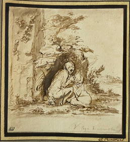
17th C Dutch Old Master Ink & Wash Painting Biblical Figures Rembrandt Pupil 1650'sJasper524.5(9.9k)See Sold PriceFeb 28, 2024
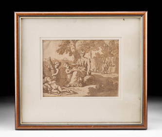
17th C. Ink Wash Drawing Ceres & Putti, ex-Christie'sArtemis Fine Arts4.8(1.4k)See Sold PriceMar 01, 2024


![[Blaeu (Willem)] partie du Comte de Charolois (1 of 0)](https://p1.liveauctioneers.com/dist/images/placeholder.jpg?height=282&quality=70)