J. M. W. Turner Signed & Owned 17th c. Art VolumeA Copy of the Second Edition of William Salmon's POLYGRAPHICE published in 1673, hand signed and inscribed by Turner "Wm Turner His Book" on the frontispiece below the title and flanking the subtitle.See Sold Price
SoldMISSOURI PACIFIC LINES WESTERN RAILROAD WALL MAPMissouri Pacific Lines wall map, c. 1930s, printed by J. W. Clement Company, Buffalo, New York, showing railroad routes through the mid and southwest, main connecting lines through Texas into Mexico sSee Sold Price
SoldVisscher & Homann Antique Maps (4)Flandriae Comitatus Pars Batava, N. Visscher, Amsterdam, Late 17th C. Plus 3 maps by J.B. Homann, Nuremberg, 18th C.. 21" x 24".See Sold Price
Sold17th c. J. Blaeu (?) Engraved Map of Asia Minor17th c. J. Blaeu (?), 1596 - 1673 copper engraved map of Asia Minor, hand colored accents including land boarders, cities and sea serpents, hand colored figures and ships, highlighted with gold indicaSee Sold Price
SoldFrance Antique Map & View, 17th C.Descriptio Veromanduorum, Antique map, Blaeu, Amsterdam, mid 17th C. W/ view Mommedy on 2 separate sheets, engraving by Israel Silvestre, 1669. 19 1/2" x 26 1/4".See Sold Price
Sold2 - 17THC. FRAMED MAPS OF BERMUDA, ONE BY W. BLAEU 1640 & 1 BY JANSSONIUS JOANNES (19" X 23 3/4")2 - 17THC. FRAMED MAPS OF BERMUDA, ONE BY W. BLAEU 1640 & 1 BY JANSSONIUS JOANNES (19" X 23 3/4")See Sold Price
Sold17TH C. MAP OF SURREYHand-colored engraving with center fold. Dimensions: (Frame) H 22.5" x W 27", (Sight) H 15" x W 19.5" Condition: Mat heavily age toned. Frame with rubbing. Paper with age toning. Unexamined out of fraSee Sold Price
Sold17th C. Map, INDIAE ORIENTALIS, Abraham OrteliusOriginal double folio hand colored map titled, "INDIAE ORIENTALIS INSULARUMQVE ADIACIENTI UM TYPUS" in stylized cartouche. Map printed circa 1587, Amsterdam, from atlas, "Theatrum Orbis Terrarum", theSee Sold Price
Sold17TH C. MAP OF GERMANY TYPUS FRISIAE ORIENTALISDimensions: (Frame) H 19.5" x W 23.75" (Sight) H 15" x W 19.5" Condition: Holes to map. Discoloration and stains to paper. Wear to frame.See Sold Price
Sold17th C. Map of Germany17th century, map of Germany, hand-colored, original frame, 19 7/8"h x 23 1/2"w (view), 27 5/8"h x 31"w (frame).See Sold Price
Sold(2) 17TH C. MAPS OF HOLLANDBoth hand colored engravings, specific areas of Holland Dimensions: (largest open) H 20.5" x W 24" Condition: Some edge damages, losses, small spots of stainingSee Sold Price
SoldBLAEU ENGRAVING MAP OF THE NETHERLANDS, 17TH C.Unframed map, engraving on paper, "Frisia Occidentalis," cartographers Adriano Metius and Gerardo Freitag, published by Willem Blaeu (Dutch, 1571-1638), reverse with text, sheet: approx 19.75"h, 23"wSee Sold Price
SoldMap of Roma, possibly 17th C. Image size: 12''H xMap of Roma, possibly 17th C. Image size: 12''H x 28''W, framed, M. Moriam fecit signed lightly.See Sold Price
SoldJ. Van R. Pinx.', still life with lobsterSigned 'J. Van R. Pinx.', a still life with lobster in the manner of W. Kalf (Dutch School, 17thC), 19thC, oil on canvas, 53 x 66 cmSee Sold Price
SoldJohan Theodor De Bry ( 1561-1623), "Nautical Map oJohan Theodor De Bry ( 1561-1623), "Nautical Map of Hudson Bay," 17th c., print, after the 16th c. original, framed, H.- 7 in., W.- 14 1/4 in.See Sold Price
Sold(MAP) BLAEU, W. & J.Virginiae partis australis... [(MAP) BLAEU, W. & J. Virginiae partis australis, et Floridae partis orientalis, interjacentiumq, regionum Nova Descriptio. [Amsterdam, c. 1640 or later] Hand-colored engraved map of the east coast. FrSee Sold Price
SoldJ.S. Virtue, The Universal Geography. 1880J.S. Virtue, The Universal Geography with Illustrations & Maps. DIV.XII. London c.1880. W. Hughes maps of China & Japan. 18 plates with illustrations by Hildibrand, Langelot, Taylor, Kohn, etc. Text pSee Sold Price
SoldMap, H. C. Evans, West PointH. C. Evans (American, 19th century), "West Point, New York," 1883, engraving, image (sight): 26"h x 20.75"w, overall (with frame): 30"h x 24.75"w. Provenance: Estate of Frank J. Caufield (San FrancisSee Sold Price
SoldNorth AmericaTitle/Content of Map: North America Date Printed: 1834 Cartographer: EDWARDS, W. (J. ARCHER, &c.) Size: 6.5X9 Unusual map printed in black with white lettering and outline. "Guide to Knowledge". "PricSee Sold Price
AthensTitle/Content of Map: Athens Date: 1852 Cartographer: CLARKE, W. B./J. HENSHALL/LEAKE/C.R. COCKERELL Size: 13.25X15.6 Street plan with some buildings. Margins browned. Sheet 168. Foxing Please note thSee Sold Price
Fine and Rare Moss Agate and Silver CandlesticksFine and Rare Moss Agate and Silver Candlesticks. 17th century, c. 1690. German. Ht. 6 1/2" W 4". Purchased from Galerie J. Kugel Paris. The Peter Tillou Collection, Litchfield, Connecticut.See Sold Price
SoldRare 17th C. Spanish Serverwalnut top, very good condition for age. See damage to feet from age and moving. 65 long x 30 w x 22 d (overhang is 9.5 inches each side).See Sold Price
Sold(8) W/C Miniature Paper, Indian, 17th c.8 Miniature Indian watercolors on hand laid paper depicting men in period costumes. India, 17th century. The largest drawing is 5.5" H x 3.5" W and the smallest is 2.25" H x 3" W. None are laid down,See Sold Price
LARGE LATE 17TH C. DUTCH CHART OF CANADA, GREAT LAKES, NEW FRANCE, LABRADOR, HUDSON BAY, BY PIERREThomaston Place Auction Galleries4.4(393)See Sold PriceFeb 24, 2024
17TH C. WORLD MAP BY NICOLAES VISSCHER (NETHERLANDS, 1618-1709)Thomaston Place Auction Galleries4.4(393)See Sold PriceFeb 24, 2024
LATE 17TH C. FRENCH MAP OF THE NEW WORLD BY ALEXIS-HUBERT JAILLOT (1632-1712)Thomaston Place Auction Galleries4.4(393)See Sold PriceFeb 24, 2024
17TH C. ANTIQUE MAP SIEGE OF LA ROCHELLE, FRANCE, FRAMEDThomaston Place Auction Galleries4.4(393)See Sold PriceFeb 24, 2024
17TH C. MAP OF THE BERKSHIRES BY JOHN SPEED, FRAMEDThomaston Place Auction Galleries4.4(393)See Sold PriceFeb 24, 2024
17TH C. ENGLISH LINEAR MAP BY OGILBY, FRAMEDThomaston Place Auction Galleries4.4(393)See Sold PriceFeb 24, 2024
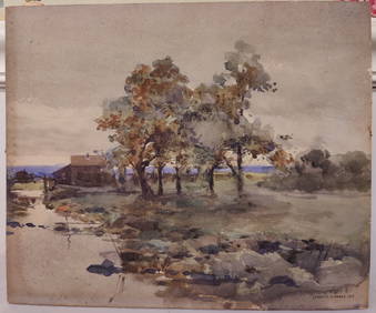
J Francis Murphy W/C New England Landscape PaintingHeritage Gallery Auctions4.4(60)See Sold PriceMar 10, 2024
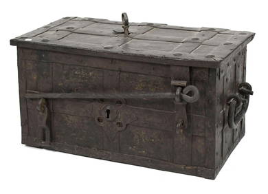
Antique 17th C English Geometric Oak Chest of DrawersKavanagh Auctions4.6(311)See Sold PriceFeb 24, 2024
Willem Blaeu, Etc. 17th C. Antiquarian Maps, 2Auctions at Showplace4.6(740)See Sold PriceMar 17, 2024
Map: A 17thC engraved and hand coloured map of Scotland titled Strath-Navernia / Strath Navern afterClaydon Auctioneers Ltd4.3(125)See Sold PriceFeb 26, 2024
Map: A 17thC engraved map of the British Isles titled A Generall Mapp of the Isles of GreatClaydon Auctioneers Ltd4.3(125)See Sold PriceFeb 26, 2024
Map: A 17thC engraved and hand coloured map of Bedfordshire after Robert Morden. Approx. 12 1/2" xClaydon Auctioneers Ltd4.3(125)See Sold PriceFeb 26, 2024
Map: A 17thC engraved and hand coloured map after Frederik de Wit (1630-1706) titled Nova Persiae,Claydon Auctioneers Ltd4.3(125)See Sold PriceFeb 26, 2024
1675 ELZEVIER JULIUS CAESAR antique ILLUSTRATED w/ MAPS ROMAN HISTORYJasper524.5(9.9k)See Sold PriceFeb 27, 2024
Tour of the Dutch East Indies, with exceptional platesPBA Galleries4.7(385)See Sold PriceMar 07, 2024
1663–1657 GAMOLOGIA PERSONARUM IMPERII ILLUSTRIUM VELLUM (ANTIQUE ROMAN LAW)NY Elizabeth 4.2(86)See Sold PriceMar 03, 2024
1675: ANTIQUE ILLUSTRATED JULIUS CAESAR MAPS OF ROMAN HISTORYNY Elizabeth 4.2(86)See Sold PriceMar 03, 2024