ATLAS of ANTIENT GEOGRAPHY by SAMUEL BUTLER 1843John McInnis Auctioneers,LLC4.5(505)See Sold PriceFeb 24, 2024
18TH C. ANTIQUE MAP: FRENCH & INDIAN WAR, FRAMEDThomaston Place Auction Galleries4.4(393)See Sold PriceFeb 24, 2024
Rand McNally Railroad Map Cabinet w/ 21 Railroad MapsRail & Road Auctions4.6(165)See Sold PriceMar 08, 2024
Keith Haring - Ink on New York Map, Best Buddies, Inscribed, Signed, and DatedSapphire Auction Gallery4.1(67)See Sold PriceMar 02, 2024
LATE 17TH C. FRENCH MAP OF THE NEW WORLD BY ALEXIS-HUBERT JAILLOT (1632-1712)Thomaston Place Auction Galleries4.4(393)See Sold PriceFeb 24, 2024
Central Railroad of New Jersey Map of Sandy Hook Route-ca. 1903JM Hobby Supply and Railroad Artifact Auctions4.4(127)See Sold PriceFeb 24, 2024
Lot of Six Mixed Atlas Box Cars-HO Scale-New in BoxJM Hobby Supply and Railroad Artifact Auctions4.4(127)See Sold PriceFeb 25, 2024
Rand McNally/Santa Fe Railroad Map of Iowa-1912JM Hobby Supply and Railroad Artifact Auctions4.4(127)See Sold PriceFeb 24, 2024
NICOLAES VISSCHER (NETHERLANDS, 1618-1709) MAP OF THE NEW WORLDThomaston Place Auction Galleries4.4(393)See Sold PriceFeb 24, 2024
17TH C. WORLD MAP BY NICOLAES VISSCHER (NETHERLANDS, 1618-1709)Thomaston Place Auction Galleries4.4(393)See Sold PriceFeb 24, 2024
Lot of Six Mixed Atlas Cabooses-HO Scale-New in BoxJM Hobby Supply and Railroad Artifact Auctions4.4(127)See Sold PriceFeb 25, 2024
Assorted maps including Bartholemew's North WalesAssorted maps including Bartholemew's North Wales Ordinance Survey map for North Wales and Manchester, Bartholemew's Bath & Bristol, North Wales, St Davis & Cardigan, Hartfordshire and BuckinghamshireSee Sold Price
SoldASSORTED 18TH CENTURY MAPS, LOT OF FIVEASSORTED 18TH CENTURY MAPS, LOT OF FIVE, engravings on paper, including Jedidiah Morse "A General Map of North America from the best Authorities", England/Wales, Germany and Belgium. Not framed. 1745-See Sold Price
SoldRowe (Robert) Rowe's Maps of the English CountiesRowe (Robert) Rowe's Maps of the English Counties,40 map sheets only, including maps of England, North Wales and South Wales, engraved maps in original hand-colouring, each c.435 x 360mm., orSee Sold Price
Principatus Wallae pars Borealis by Jan Jansson, 17thAmsterdam: ca. 1646, copper engraved map of North Wales including Anglesey, Caernavonshire, Denbighshire, Flintshire, Merioneth and Montgomery. With antique coloring, decorative title cartouche,See Sold Price
SoldLOT ASSORTED VINTAGE AND ANTIQUE MAPS INCLUDING UNITEDLOT ASSORTED VINTAGE AND ANTIQUE MAPS INCLUDING UNITED STATES OF NORTH AMERICASee Sold Price
SoldMiscellany.- A mixed, group of maps and views-. A mixed group of maps, views and decorative items,including maps of the City of Dublin (Sewers) , North Wales, Worcestershire, Northamptonshire, Westmorland, Warwickshire, Staffordshire, viSee Sold Price
6 assorted folding maps6 assorted folding maps including 1931 road map of Florida; New York to Buffalo turist guide; 1930 road map of North & South Carolina. Used condition; stains; tears; written on.See Sold Price
Sold6 assorted folding maps6 assorted folding maps including 1931 road map of Florida; New York to Buffalo turist guide; 1930 road map of North & South Carolina. Used condition; stains; tears; written on.See Sold Price
8 Maps from Cary’s New and Correct Atlas 1793Including: South Wales (rough) North Wales Surrey Sussex Worcestershire Warwickshire Oxfordshire Rutlandshire Measures: 9 ¾ x 11 ½ Condition:See Sold Price
Six 19th century and later linen backed maps includingSix 19th century and later linen backed maps including W & A K Johnstons map of the railway systems of England and Wales showing canals, Imperial map of Wales, New Chart of North and Central England,See Sold Price
SoldHollar (Wenceslaus) The Kingdome of England & PrinHollar (Wenceslaus) The Kingdome of England & Principality of Wales,engraved title, 6 engraved folding maps, and 1 single page engraved map, including The Isle of Man, The North Part of EnglanSee Sold Price
Hollar (Wenceslaus) The Kingdome of England & PrinHollar (Wenceslaus) The Kingdome of England & Principality of Wales,engraved title, 6 engraved folding maps, and 1 single page engraved map, including The Isle of Man, The North Part of EnglanSee Sold Price
SoldBoswell Life of Johnson 6 vols. finely boundHeading: (Fine Bindings) Author: Boswell, James Title: Boswell's Life of Johnson, including Boswell's Journal of a Tour of the Hebrides and Johnson's Diary of a Journey into North Wales Place PublisheSee Sold Price
SoldASSORTED ATLASES / CARTOGRAPHY AND RELATED VOLUMES /ASSORTED ATLASES / CARTOGRAPHY AND RELATED VOLUMES / RESEARCH MATERIALS, LOT OF 22, including "The Discovery of North America" by Cumming, Skelton, and Quinn; one 1949 reprint of the 1776 "TopographicSee Sold Price
SoldA Small Group Of Maps Of The British IslesA Small, Mixed Group Of Maps Of The British Isles, including several of Scotland (7), Ireland (5), England and Wales (12), by S.Hall, J. Bartholemew, and others, lithographs and engravings, vSee Sold Price
SoldASSORTED AMERICANA VOLUMES, LOT OF TENASSORTED AMERICANA VOLUMES, LOT OF TEN, including "Historical and Pictorial Review Ninth Division, United States Army, Fort Bragg, North Carolina", 1941; United States Military Academy, "The HowitzerSee Sold Price
SoldA collection of assorted maps including geological,A collection of assorted maps including geological, gold reserves, ordnance etc of Africa, Canada, Europe etc.See Sold Price
SoldCollection of 14 assorted mapsCollection of 14 assorted maps including New York; National Geographic Magazine's The White Mountains of New Hampshire; Johnson's New Jersey; Wisconsin; Rand McNally Railroad map of Illinois. Foxing/sSee Sold Price
SoldEphemeral Map Lot (12)Twelve pieces of assorted maps including newspaper and magazine pull-outs. Mostly 1950's. All are in AS-IS condition. 16" x 24" and varying sizesSee Sold Price
SoldAntique Maps by Augustus Mitchell (8)Various maps, including North America, South America, Europe, Italy, Spain, Greece, Brazil. Hand-colored engravings. S. Augustus Mitchell, Philadelphia, c. 1850. 17 1/2" x 14 1/4".See Sold Price
SoldA. K. JOHNSTON 5 National Atlas Maps, [1860]A. K. JOHNSTON 5 National Atlas Maps, [1860] Hand-coloured map. Folio. Including North America, Canada, China, India, and Chart of the World. Some wear at folds, else good and clean. (5) large folioSee Sold Price
SoldShipping Company silver-plated ware, including NorShipping Company silver-plated ware, including North Wales SS Co sugar basin and lid, GSN Co milk jug, pair Anchor Line salt pots, BISN Co and P&O mustard and salt pots (15)See Sold Price
SoldMaps of China, Russia in Asia and Tartary, Egypt, etc.(lot of 4) Assorted Maps including "A New Map of the World on the Globular Projection," "China," "Russia in Asia and Tartary," and "Egypt," all hand-colored lithographic transfer from original engraviSee Sold Price
Collection of assorted mapsCollection of assorted maps including city of New York the 5 boroughs, Harlem line, the town at Central Park, map of Boston showing new division of wards 1886. Tears, staining, taped.See Sold Price
Sheaffer Cartridge Assorted Fountain Pen Lot (20)North American Pen Auctions LTD4.4(12)See Sold PriceFeb 24, 2024
Large lot of assorted prints. 18th-20th century. To include: North American and other maps, CivilTremont Auctions4.5(297)See Sold PriceFeb 25, 2024
Portfolio of 15 County Maps by Robert Morden (English 1650-1703)Nadeau's Auction Gallery4.7(409)See Sold PriceFeb 24, 2024
These United States 1968 Folio Size HardbackNorth American Artifact Auctions4.7(198)See Sold PriceApr 20, 2024
W. Taylor Oughton (American, 1925-2018) Illustration Art, Sports, FarmersHoch LTD.4.6(79)See Sold PriceFeb 25, 2024
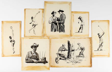
W. Taylor Oughton (American, 1925-2018) Western Illustration Art, CowboysHoch LTD.4.6(79)See Sold PriceFeb 25, 2024
W. Taylor Oughton (American, 1925-2018) Illustration Art, Incl. WWIIHoch LTD.4.6(79)See Sold PriceFeb 25, 2024
Carte de la partie septentrionale d'Afrique, ou de la Barbarie… BONNE 1780 mapJasper524.5(9.9k)See Sold PriceFeb 28, 2024
Afrique. Pays des Hottentots #51. Botswana South Africa. VANDERMAELEN 1827 mapJasper524.5(9.9k)See Sold PriceFeb 28, 2024
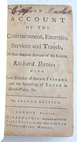
RICHARD DAVIES' 1752 "AN ACCOUNT OF EXERCISES, SERVICES, AND TRAVELS" VINTAGE AMERICANNY Elizabeth 4.2(86)See Sold PriceMar 03, 2024
Hudson River Map & North American Postcards, 45Auctions at Showplace4.6(740)See Sold PriceFeb 13, 2025


![A. K. JOHNSTON 5 National Atlas Maps, [1860] (1 of 1)](https://p1.liveauctioneers.com/1187/57305/28080900_1_x.jpg?height=282&quality=70&version=1403622104)