SoldAncient Britain ITitle: Ancient Britain I Cartographer: WALKER, J. & C. Publisher: Baldwin & Cradock/S.D.U.K. Brief Description: Roman England and Wales. Height X Width: 14.5x 11.3 Reserve: $25.00 Shipping: DomesSee Sold Price
England IITitle: England II Cartographer: WALKER, J. & C. Publisher: Baldwin & Cradock/S.D.U.K. Brief Description: Northwest England, Anglesey, Caernarvonshire, etc. Called "England. West-Central Wales to WarwiSee Sold Price
Sold10 Maps of India. 1831-1835.[Asia/India] 10 Maps of India published for the Society for the Diffusion of Useful Knowledge. Lon: Baldwin & Cradock, 1831-1835. The maps are numbered with the highest being the Index Map, numbered "See Sold Price
SoldA Geological Map of England, Wales and Part of ScoA Geological Map of England, Wales and Part of Scotland Showing Also the Inland Navigation by Means of Rivers and Canals (T. & C. Walker, 1850s?), 6.5 x 10 6.5 x 10See Sold Price
19th century geological map of England & Wales and Part19th century geological map of England & Wales and Part of Scotland, hand coloured, by J & L Walker of Burleigh Street, The Strand, London, 143cm x 99cmSee Sold Price
SoldPhysical Map of England & Wales With Part of ScotlandTitle/Content of Map: Physical Map of England & Wales With Part of Scotland Date: 1848 Cartographer: HUGHES, W. (DRAWN BY) Publisher: THE NATIONAL SOCIETY Size: 17.5Height - 12.8Width Published by theSee Sold Price
19th century geological map of England & Wales and Part19th century geological map of England & Wales and Part of Scotland, hand coloured, by J & L Walker of Burleigh Street, The Strand, London, 143cm x 99cmSee Sold Price
Mallet: Antique Map of Ancient Britain, 1683Title/Content of the Map: 'Heptarchie des Saxons' England. Wales and parts of Scotland and of Ireland. ANCIENT BRITAIN. Anglo-Saxon Kingdoms. Date Printed: 1683 Image Size: Approx Overall page size 13See Sold Price
SoldANCIENT EGYPT & Nile Valley. Ancient place names.Reserve Reduced! TITLE/CONTENT OF MAP: 'ANCIENT EGYPT' DATE PRINTED: This map was originally published by Baldwin & Cradock in 1831; this date is printed on the map. This edition of the map was printeSee Sold Price
WARSAW WARSZAWA antique town city map plan. BuildingTITLE/CONTENT OF MAP: 'WARSAW (WARSZAWA)' DATE PRINTED: This map was originally published by Baldwin & Cradock in 1831; this date is printed on the map. This edition of the map was printed and publishSee Sold Price
ANCIENT BRITAIN. Anglo-Saxon Kingdoms. 'Heptarchie desReserve Reduced! TITLE OF THE MAP: 'Heptarchie des Saxons' England. Wales and parts of Scotland and of Ireland. DATE PRINTED: 1683 IMAGE SIZE: Approx Overall page size 13 x 21cm approximately (5 x 8 iSee Sold Price
Mallet: Antique Map of Ancient Britain, 1683Title/Content of Map: 'Heptarchie des Saxons' ANCIENT BRITAIN. Anglo-Saxon Kingdoms. England. Wales and parts of Scotland and of Ireland. Date Printed: 1683 Image Size: Approx Overall page size 13 x 2See Sold Price
WARSAW WARSZAWA antique town city map plan. BuildingTITLE/CONTENT OF MAP: 'WARSAW (WARSZAWA)' DATE PRINTED: This map was originally published by Baldwin & Cradock in 1831; this date is printed on the map. This edition of the map was printed and publishSee Sold Price
SPAIN SOUTH.Sevilla Granada Cordoba Jaen MurciaReserve Reduced! TITLE/CONTENT OF MAP: 'SPAIN (ESPAÑA), III., South: Madrid to Tarifa' DATE PRINTED: This map was originally published by Baldwin & Cradock in 1831; this date is printed on the map. TSee Sold Price
MADRID antique town city map plan. Original outlineTITLE/CONTENT OF MAP: 'MADRID' DATE PRINTED: This map was originally published by Baldwin & Cradock in 1831; this date is printed on the map. This edition of the map was printed and published by ChapmSee Sold Price
NORTH POLE ARCTIC to 45˚ N Latitude.Alaska as Russian Territory.SDUK 1844 mapTITLE OF PRINT (NOT PRINTED ON THE PAGE):'WORLD ON GNOMONIC PROJECTION, V., From North Pole to 45˚ N Lat' DATE PRINTED: This map was originally published by Baldwin & Cradock in 1831; this date iSee Sold Price
MADRID antique town city map plan. Original outlineTITLE/CONTENT OF MAP: 'MADRID' DATE PRINTED: This map was originally published by Baldwin & Cradock in 1831; this date is printed on the map. This edition of the map was printed and published by ChapmSee Sold Price
ANCIENT BRITAIN. Anglo-Saxon Kingdoms. 'Heptarchie des Saxons'. MALLET 1683 mapTITLE OF THE MAP: 'Heptarchie des Saxons' (De L'Europe) England. Wales and parts of Scotland and of Ireland. DATE PRINTED: 1683 IMAGE SIZE: Approx Overall page size 13 x 21cm approximately (5 x 8 inchSee Sold Price
AUSTRALASIA POLYNESIA PACIFIC OCEAN. On Gnomonic Projection. SDUK 1844 old mapTITLE OF PRINT (NOT PRINTED ON THE PAGE):'WORLD ON GNOMONIC PROJECTION, III., Polynesia' DATE PRINTED: This map was originally published by Baldwin & Cradock in 1831; this date is printed on the map.See Sold Price
SOUTH POLE ANTARCTIC. Gnomonic Projection. To 45˚ S Latitude. SDUK 1844 mapTITLE OF PRINT (NOT PRINTED ON THE PAGE):'WORLD ON GNOMONIC PROJECTION, VI., From South Pole to 45˚ S Lat' DATE PRINTED: This map was originally published by Baldwin & Cradock in 1831; this dateSee Sold Price
ASIA AUSTRALIA on Gnomonic Projection. China India Persia. SDUK 1844 old mapTITLE OF PRINT (NOT PRINTED ON THE PAGE):'WORLD ON GNOMONIC PROJECTION, IV, Asia.' DATE PRINTED: This map was originally published by Baldwin & Cradock in 1831; this date is printed on the map. This eSee Sold Price
Volumes 1, 2 & 6 of Sporting Magazine, published byVolumes 1, 2 & 6 of Sporting Magazine, published by Baldwin & Cradock, London, 1831, 1832 & 1834 not illustratedSee Sold Price
Map of Russia in Europe Part II, 1835Map of Russia in Europe Part II. Baldwin & Cradock/SDUK., Walker, J. & C. 1835-07-01. From the Imperial atlas, Piadichev and Lutke. Called "Russia II. North-east..." on later indexes. Brown, dry and fSee Sold Price
SoldWalker (J. & C.) A Geological Map of England, WaleWalker (J. & C.) A Geological Map of England, Wales, and Part of Scotland,with Geological and Mineralogical Section from Land's End to the German Ocean, and St. George's Channel to the GermanSee Sold Price
William Henry Bartlett (Irish,1858-1932) oil painting antiqueBroward Auction Gallery4.7(292)See Sold PriceMar 17, 2024
Thirty-Three Assorted Railroad and Transit Buttons - Kansas City Southern, United Transit ofRail & Road Auctions4.6(165)See Sold PriceMar 07, 2024
[CHARLES II, KING OF ENGLAND (1630-1685)]. His Majestie’s D...Potter & Potter Auctions4.6(545)See Sold PriceMar 07, 2024
[ENGLISH REFORMATION]. An Inventory of the Plate Belonging ...Potter & Potter Auctions4.6(545)See Sold PriceMar 07, 2024
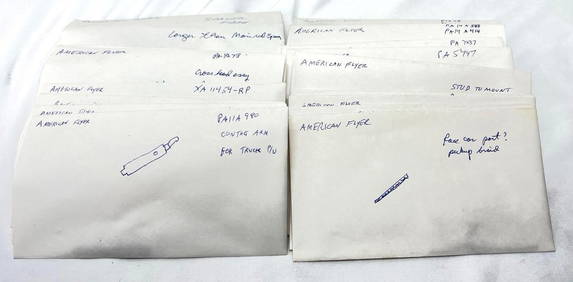
Postwar American Flyer S/HO Gauge parts in envelopesElliott Auctions4.6(134)See Sold PriceFeb 24, 2024
Attrib. Edwin Henry Boddington Jr., "Mountain ..."Stefek's Auctioneers & Appraisers4.6(113)See Sold PriceFeb 28, 2024
Gigantic Lot of Cameras & Photography EquipmentOld Kinderhook Auction Company4.6(217)See Sold PriceMar 05, 2024
NORTH AFRICA BARBARY. Parts of Tripoli (Libya) & Egypt. Tribes. SDUK 1844 mapJasper524.5(9.9k)See Sold PriceFeb 28, 2024
NORTH AFRICA BARBARY. Parts of Tripoli (Libya) & Egypt. Tribes. SDUK 1844 mapJasper524.5(9.9k)See Sold PriceFeb 28, 2024
NORTH AFRICA BARBARY. Parts of Tripoli (Libya) & Egypt. Tribes. SDUK 1848 mapJasper524.5(9.9k)See Sold PriceFeb 28, 2024
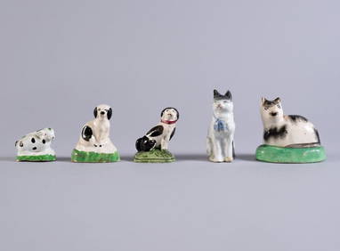
FIVE STAFFORDSHIRE HOLLOW POTTERY FIGURESPridham's Auctions & Appraisals4.7(223)See Sold PriceMar 02, 2024
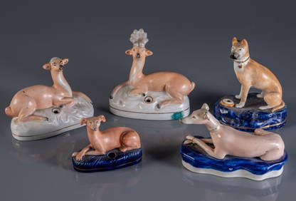
FIVE STAFFORDSHIRE POTTERY DOG QUILL HOLDERSPridham's Auctions & Appraisals4.7(223)See Sold PriceMar 02, 2024
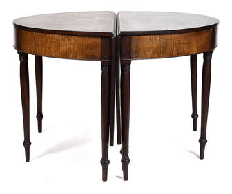
19TH C. NE TIGER MAPLE & CHERRY BANQUET TABLE.William Smith Auctions4.6(147)See Sold PriceMar 06, 2024
Herman Moll A New Map of Ye North Parts of AmericaWillow Auction House4.5(289)See Sold PriceMar 14, 2024
(2) MAGIC LANTERN SANDHAM & BUCKEYE ELECT SCOPEAustin Auction Gallery4.7(1.2k)See Sold PriceApr 12, 2024


![[CHARLES II, KING OF ENGLAND (1630-1685)]. His Majestie’s D... (1 of 3)](https://p1.liveauctioneers.com/928/318880/171360926_1_x.jpg?height=282&quality=70&version=1707501302)
![[ENGLISH REFORMATION]. An Inventory of the Plate Belonging ... (1 of 2)](https://p1.liveauctioneers.com/928/318880/171360970_1_x.jpg?height=282&quality=70&version=1707501302)