ATLAS of ANTIENT GEOGRAPHY by SAMUEL BUTLER 1843John McInnis Auctioneers,LLC4.5(505)See Sold PriceFeb 24, 2024
18TH C. ANTIQUE MAP: FRENCH & INDIAN WAR, FRAMEDThomaston Place Auction Galleries4.4(393)See Sold PriceFeb 24, 2024
Rand McNally Railroad Map Cabinet w/ 21 Railroad MapsRail & Road Auctions4.6(165)See Sold PriceMar 08, 2024
Keith Haring - Ink on New York Map, Best Buddies, Inscribed, Signed, and DatedSapphire Auction Gallery4(67)See Sold PriceMar 02, 2024
LATE 17TH C. FRENCH MAP OF THE NEW WORLD BY ALEXIS-HUBERT JAILLOT (1632-1712)Thomaston Place Auction Galleries4.4(393)See Sold PriceFeb 24, 2024
Central Railroad of New Jersey Map of Sandy Hook Route-ca. 1903JM Hobby Supply and Railroad Artifact Auctions4.4(127)See Sold PriceFeb 24, 2024
Lot of Six Mixed Atlas Box Cars-HO Scale-New in BoxJM Hobby Supply and Railroad Artifact Auctions4.4(127)See Sold PriceFeb 25, 2024
Rand McNally/Santa Fe Railroad Map of Iowa-1912JM Hobby Supply and Railroad Artifact Auctions4.4(127)See Sold PriceFeb 24, 2024
NICOLAES VISSCHER (NETHERLANDS, 1618-1709) MAP OF THE NEW WORLDThomaston Place Auction Galleries4.4(393)See Sold PriceFeb 24, 2024
17TH C. WORLD MAP BY NICOLAES VISSCHER (NETHERLANDS, 1618-1709)Thomaston Place Auction Galleries4.4(393)See Sold PriceFeb 24, 2024
Lot of Six Mixed Atlas Cabooses-HO Scale-New in BoxJM Hobby Supply and Railroad Artifact Auctions4.4(127)See Sold PriceFeb 25, 2024
SoldA Large Grouping of Cincinnati Survey MapsCourthouse survey maps of Cincinnati Ohio and its neighborhoods, lot includes Miami White Water, Colerain, Green Township, Cumminsville, Lockland Reading, College Hill, Springfield, Mill Creek; largesSee Sold Price
SoldA Large Group of Cincinnati Survey MapsCourthouse survey maps of Cincinnati Ohio and its neighborhoods, lot includes Storrs, Riverside, Miamitown Elizabeth Town, Spencer, Sycamore, Glendale, and Harrison; largest 34 x 22 inches (frame). OvSee Sold Price
SoldA Large Group of Cincinnati Survey MapsCourthouse survey maps of Cincinnati Ohio and its neighborhoods, lot includes Columbia Tusculum, Symmes, Mount Washington, Fairmount, Anderson and Crosby. Overall good condition.See Sold Price
SoldA Large Group of Cincinnati Survey MapsCourthouse survey maps of Cincinnati Ohio and its neighborhoods, lot includes Mt. Auburn, Walnut Hills, Corryville, Clifton, Camp Washington and Avondale; largest 34 x 22 inches (frame) Overall good cSee Sold Price
SoldA Large Group of Cincinnati Land Survey MapsCourthouse survey maps of downtown Cincinnati Ohio and its wards, lot includes Cincinnati embracing its wards Part X, V, III, VI, IV, I and II; largest 42 x 22 inches. Overall good condition.See Sold Price
SoldLarge grouping of ephemera, most from the Holmes familyLarge grouping of ephemera, most from the Holmes family of Maine and Ohio. To include house rental agreement from Ohio 1835 with hand drawn survey map on verso, various deeds from Ohio and Maine fromSee Sold Price
SoldLarge New Jersey Archive - 18th and 19th CenturyLarge grouping of New Jersey related land documents, manuscript survey maps, receipts, letters, and miscellaneous documents dating from the early 18th century to the mid 19th century. Family names incSee Sold Price
SoldSurveying Archive-Hardenburgh Patent.Grouping of 6 large copy survey maps relating to the development of portions of the Hardenburgh Patent in New York State in the early 19th century. Maps are all manuscript with details of property ownSee Sold Price
SoldA Grouping of Six Maps of America and its StatesAmerican survey maps, includes a plan of Cincinnati and vicinity, Ohio and its counties, United States of America, Ohio River, Downtown Cincinnati outlines, Hamilton County Ohio; 22.5 x 49 inches (fraSee Sold Price
SoldLarge survey map of California, 1860Heading: (California) Author: Title: Map of Public Surveys in California, to accompany report of Surveyor General, 1860 Place Published: New York Publisher:Lith. of J. Bien Date Published: 1See Sold Price
Large survey map of California, 1860Heading: (California) Author: Title: Map of Public Surveys in California, to accompany report of Surveyor General, 1860 Place Published: New York Publisher:Lith. of J. Bien Date Published: 1See Sold Price
SoldLarge Survey Map of Florida 1856Heading: Author: U.S. State Surveys Title: Map of the State of Florida, Showing the Progress of the Surveys. Accompanying Annual Report of the Surveyor General for 1856 Place Published: Washington PuSee Sold Price
SoldLarge Survey Map of Texas for Pacific RailroadTitle: Map of the Survey for a Route for the Pacific Railroad near the 32nd Parallel between the Rio Grande and Red River under Orders of Jefferson Davis, Secretary of War, by Capt. Pope Assisted by LSee Sold Price
SoldLarge Survey Map of Florida 1856Title: Map of the State of Florida, Showing the Progress of the Surveys. Accompanying Annual Report of the Surveyor General for 1856 Author: U.S. State Surveys Description: Lithographed map. 73x68 cm.See Sold Price
Large Survey Map of Florida 1856Title: Map of the State of Florida, Showing the Progress of the Surveys. Accompanying Annual Report of the Surveyor General for 1856 Author: U.S. State Surveys Description: Lithographed map. 73x68 cm.See Sold Price
Large Survey Map of Texas for Pacific RailroadTitle: Map of the Survey for a Route for the Pacific Railroad near the 32nd Parallel between the Rio Grande and Red River under Orders of Jefferson Davis, Secretary of War, by Capt. Pope Assisted by LSee Sold Price
SoldLarge Survey Map of California 1879Title: State of California Author: U.S. State Surveys Description: Color photo-litho map, compiled by C. Roeser. 97x84 cm. (38x33"), folding into cloth covers 28.5x10.5 cm. (11¼x4¼").Apparently theSee Sold Price
SoldLarge survey map of Idaho 1891Title: State of Idaho Author: U.S. State Surveys Description: Color lithographed map. 102x66 cm. (40x26").Large, detailed survey map of Idaho. Heading: zzf(Idaho)Place Published: Washington Publisher:See Sold Price
Large Survey Map of Section of NorristownLarge Survey Map of Section of Norristown, PA Map titled "Plan of Lots laid out and surveyed by L. E. Corson 1852". Map measures 26.5" x 42" and is laid to larger linen backing. Map by Duval shows SchSee Sold Price
SoldFRAMED NOAA CHART- DAMARISCOTTA, SHEEPSCOT & KENNEBECLarge Survey Map of Midcoast Maine Rivers, #13293, includes South Bristol Harbor, Christmas Cove and Boothbay, legend includes the NOAA 25th Anniversary emblem, in a blue lacquered frame with mat andSee Sold Price
Sold7 large Coast Survey maps[Coast Survey]. 7 Maps. About 23 x 34 - 43 x 28 in., most in not all published by M.F. Maury. ++ Maury's Wind & Current Chart: No. 5, Series A. (1850). Charts the Hudson Bay region, with the St. LaureSee Sold Price
SoldLarge Grouping of Vintage Maps, EtcLarge Grouping of Vintage Maps, Travel Guides, and Time Tables. Mostly European and American Cities and Destinations.See Sold Price
SoldLarge Grouping Of WWII Maps, Press Correspondents AndLarge Grouping Of WWII Maps, Press Correspondents, Soldiers poetry(a must read), Versailles post card book, American Red Cross map of Paris, Guilman Guide Paris, The New pictorial map of London, War aSee Sold Price
Allied Advance 1918 - World War One MapAllied Advance 1918 - World War One World War I One. Linen backed. Map 9 - Ordnance Survey - Large Map with Scale Publisher British Dated: 1919 Type:See Sold Price
Large grouping of classical prints. 17th-19th centuries. Portraits of various philosophical,Tremont Auctions4.5(297)See Sold PriceFeb 25, 2024
Rand McNally & Co's New Ideal State and County Survey and Atlas 1911North American Artifact Auctions4.7(198)See Sold PriceApr 20, 2024
[MAP]. NICHOLLS, Sutton (1668-1729). An Epitome of Sr. Will...Potter & Potter Auctions4.6(545)See Sold PriceMar 07, 2024
1736 LARGE MAP OF SILESIA POLAND OPPAVIENSIS antique 25 by 34 3/4"Jasper524.5(9.9k)See Sold PriceFeb 27, 2024
1736 LARGE MAP OF SILESIA POLAND KARNOVIENSIS antique 25 x 4 3/4" Duchy of KrnovJasper524.5(9.9k)See Sold PriceFeb 27, 2024
Birmingham.- Commercial map.- Smith (J. Pigott) To the Right Honourable William Earl of Dartmouth...Forum Auctions4.3(53)See Sold PriceFeb 29, 2024
Stanford, Edward 1901 Large Map. Geological Map of the British IslesAlbion Auctions4.6(341)See Sold PriceMar 01, 2024
Perry, Matthew C. 1856 Large Map. Shah Bay, Lew Chew I. JapanAlbion Auctions4.6(341)See Sold PriceMar 01, 2024
Large Grouping Vintage Fashion and Costume JewelryCordier Auctions & Appraisals4.4(1.5k)See Sold PriceMar 02, 2024
Large Grouping Of Superbowl Memorabilia Incl FootballCordier Auctions & Appraisals4.4(1.5k)See Sold PriceMar 02, 2024
Large Grouping Of Ephemera Incl Bonds & MortgageCordier Auctions & Appraisals4.4(1.5k)See Sold PriceMar 02, 2024
Large Grouping Political Ephemera incl First Day CoversCordier Auctions & Appraisals4.4(1.5k)See Sold PriceMar 02, 2024
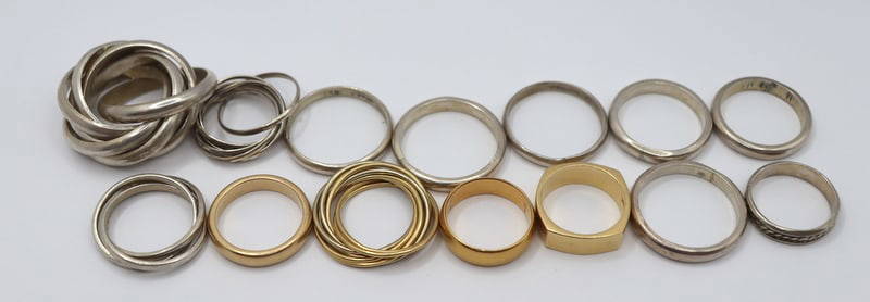
JEWELRY. Large Grouping of Sterling and Gold BandsClarke Auction Gallery4.6(557)See Sold PriceMar 10, 2024


![[MAP]. NICHOLLS, Sutton (1668-1729). An Epitome of Sr. Will... (1 of 1)](https://p1.liveauctioneers.com/928/318880/171361281_1_x.jpg?height=282&quality=70&version=1707501302)