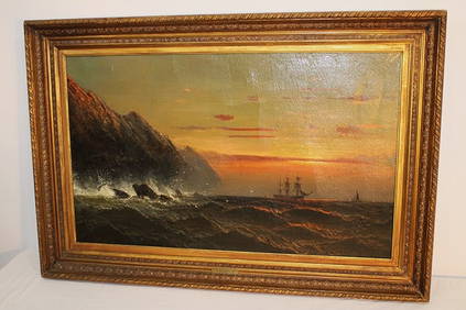
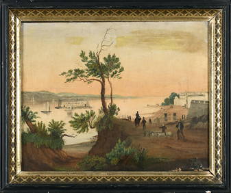
Wonderful Oil On Canvas Painting Of Ship At Sea Signed James HamiltonRalph Fontaine Heritage Auctions Inc.4.7(235)See Sold PriceFeb 25, 2024
Large Collection of Antique Buttons DisplayPremier Auction Galleries4.3(329)See Sold PriceMar 09, 2024
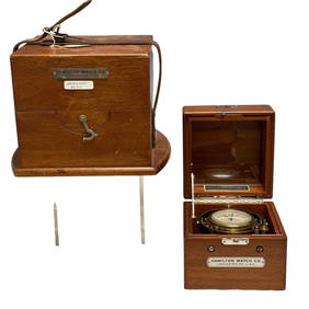
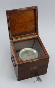
Hamilton Chronometer Model 22 Ship Clock 8630Premier Auction Galleries4.3(329)See Sold PriceMar 09, 2024
CASED HAMILTON WATCH CO. MARINE CHRONOMETER Lancaster, Pennsylvania, 20th Century Case height 7.5".Eldred's4.7(409)See Sold PriceFeb 27, 2024
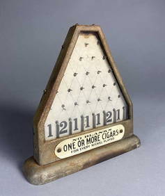
Hamilton Daisy Coin Drop Cigar Trade StimulatorEpic Auctions and Estate Sales4.6(204)See Sold PriceMar 02, 2024
HELMUT NEWTON, TERI ROJAS AND HER SISTER CHERI HAMILTON, SANTA BARABARA, 1984White Knight Auction, Inc4.7(248)See Sold PriceFeb 25, 2024
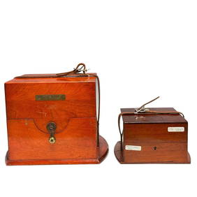
Hamilton Watch Co. Ship Clock Carrying/Storage Cases (2)Premier Auction Galleries4.3(329)See Sold PriceMar 09, 2024
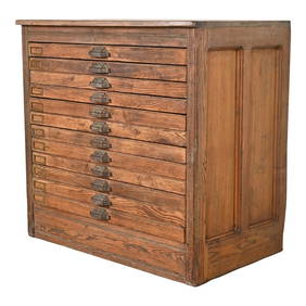
Antique Pine 12-Drawer Blueprint Flat File Cabinet by Hamilton, Circa 1900Liberty & 33rd Furniture Co.4.4(11)See Sold PriceFeb 27, 2024
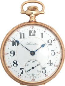
Heavy 14K Gold 23J Hamilton 950 Railroad Pocket Watch Double Sunk DialHess Fine Auctions4.5(197)See Sold PriceMar 02, 2024
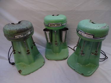
3 VINTAGE HAMILTON BEACH JADEITE GREEN 3 HEADED MILK SHAKE MIXERS W/ 2 STAINLESS STEEL CUPS 20" HIGHTHOS. CORNELL GALLERIES, LTD./CORNELL AUCTIONS, OBJECTS, AND TRADE4.5(313)See Sold PriceFeb 24, 2024
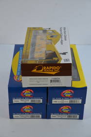
5-Pack of Mixed Cabooses-THB/ERIE/DTI/MEC/BM-Athearn/Raipdo-HO Scale-New in BoxJM Hobby Supply and Railroad Artifact Auctions4.4(126)See Sold PriceFeb 25, 2024
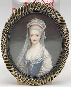
Portrait Miniature Signed Berry 1782 Sterling Silver FrameHeritage Gallery Auctions4.4(56)See Sold PriceMar 10, 2024
SoldA Grouping of Six Maps of America and its StatesAmerican survey maps, includes a plan of Cincinnati and vicinity, Ohio and its counties, United States of America, Ohio River, Downtown Cincinnati outlines, Hamilton County Ohio; 22.5 x 49 inches (fraSee Sold Price
USA map in six sheets by Petermann, 1874Map of The United States of America in 6 sheets on linen canvas. August H. Peterman. Map in scale 1:3.7000.000 Published by Justus Perthes, Gotha Germany 1874. Engraved by Eberhardt Kuhn Metzeroth & WSee Sold Price
SoldSix British and American Historical EngravingsGroup of Six British and American Historical Engravings, 19th century, including "Map of The United States of America and Nova Scotia", engraved by Fenner, Sears and Company, published by T. Hinton anSee Sold Price
SoldSix framed maps including J.H. Colton Illinois,Six framed maps including J.H. Colton Illinois, Augustus Mitchell 1877 World on the Mercator Projection, State of Illinois by Mitchell, North America, Chicago City, 19th century, and the Upper TerritoSee Sold Price
SoldConfederate States case map, Edward StanfordDesc: Stanford's New Hand Map of the United States of North America; boundaries of seceded states delineated with original hand coloring; six sequential images mounted to canvas backing and folded toSee Sold Price
Ettling: Antique Map of North America, 1862TITLE/CONTENT OF MAP: 'North America' State borders differ from those later settled. DATE PRINTED: 1862 IMAGE SIZE: Approx 65.0 x 45.5cm, 25.5 x 17.75 inches (Large); Please note that this is a foldinSee Sold Price
Sold18TH C MAP, NORTH AMERICA, UNITED STATES & MEXICOJohann Baptist Homann (German, 1664-1724). "Regni Mexicani seu Novae Hispaniae" - circa 1725, engraving with hand coloring. Approx. 20.75" x 24" (sheet) Item from the Estate of Forest "Tag" Hunter, AtSee Sold Price
SoldOrtelius Map of America 1593 State 3ORTELIUS, Abraham (1527-1598).America Sive Novi Orbis Nova Descriptio.Engraved map with original hand color.Antwerp, c. 1595 (State 3).13 3/4" x 19 1/4" visible, 21 1/2" x 26" framed.Very Fine exampleSee Sold Price
SoldU.S. BADGES GROUPINGFine grouping of six United States badges, including a U.S. Marshal Bicentennial Commemorative badge, U.S. Marine Corps Military Police badge, a Department of the Air Force Air Police badge, a 2005 UnSee Sold Price
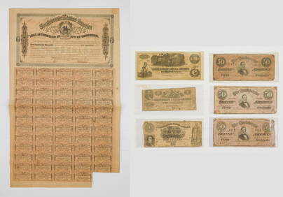
SoldCONFEDERATE STATES NOTE LOT OF 6 $20 1864 CS-67Grouping of six Confederate States notes, all $20 denomination, VF or better, two are sequential in their serial numbers, all Richmond 1864, CS-67.See Sold Price
SoldGrp: 6 Maps of South AmericaGroup of six maps of South America. Includes two maps of the continent overall; three maps of the southern section of South America, including Argentina, Chile, Paraguay, Uruguay, Bolivia, and in oneSee Sold Price
Rare Set Boyhood School House Watercolor Mapsby George Lantz (b. 1804) of Frederick Co, Maryland. The maps are exceptionally executed and maliciously detailed. The six maps include South America, Asia, Europe, North America, Africa and Britain.See Sold Price
Grouping of Historic MapsGrouping of six historic maps including; 1.) Map titled"Geological Map of The District Between Keweenaw Bay and Chocolate River, Lake Superior, Michigan" published in New York by Ackerman"s LithographSee Sold Price
SoldGrouping of WWI PostersGrouping of six United States World War I posters including; 1.) A Liberty Loan poster with artwork by Howard Chandler Christy. Text reads "Americans all! Victory Liberty Loan" and honor roll list ofSee Sold Price
SoldVintage Patriotic Postcards (18) and 7 Maps (118922)Lot of three plastic wrapped frameable items, including vintage patriotic postcards, set of six old maps of America, and a map of California, c1915-1916. Includes 23 x 22 in. poster board with 18 patrSee Sold Price
c. 1636 America Map with California as an IslandHistoric Maps c. 1636 First State "America Septentrionalis" by Henricus Hondius Impressively Designed Map, California as an Island c. 1636 First State Map, "America Septentrionalis" by Henricus HondiuSee Sold Price
1762 Antique Map "America Divided by Major States"Original 18th Century Antique Map Entitled L'Amerique divisee Par Grands Etats [America divided by major states] Dated 1762 (dated in the cartouche) by Jean Denis Janvier, Sr. (fl. 1746-1779)(a/k/a RoSee Sold Price
SoldEarly Map of America, Eastern United States, M. SeutterTitled "Novi Belgii in America Septentrionali" with very elaborate cartouche and with vignette view of New Amsterdam (New York). Exquisite color, well preserved, laid down. Size: 19 7/8" x 22 3/4" (siSee Sold Price
Colton's United States of America Map, 1859Title/Content of Map: Colton's United States of America Date Printed: 1859 Cartographer: COLTON, J.H. Size: 15.5X26 Scarce map showing entire U.S. with towns, townships, topography and railroads. WithSee Sold Price
SoldSix vintage 1833 maps of states: Mississippi, IlliSix vintage 1833 maps of states: Mississippi, Illinois, Arkansas, Wisconsin, Louisiana and southern states; some rips and stains, 16" x 13 1/2"See Sold Price
HANDLEN HOUSE , UNITED STATES OF AMERICA MAP& TEMPLE PUBLISHING COMPANY PRESIDENTS OF USA PRINT (FOXING) LARGEST IS 33" x 27"See Sold Price
SoldUnited States of America Map w/ Indian TerritoryMap of British Possessions and The United States Shows Dakota as a single territory and Indian Territory Dimensions: 10 x 13" Condition Report Very good.See Sold Price
SoldSix volumes on maps of AmericaTitle: Six volumes on maps of America Author: ** Description: Includes: * Wheat, Carl I. Mapping the American West 1540-1857: A Preliminary Study. pp. 19-194 within: Proceedings of the American AntiquSee Sold Price
SoldTwo Maps - North America & The United States - 1800Two Maps - North America & The United States Published by Cummings & Hilliard, Boston, c. 1800See Sold Price
Arrowsmith & Lewis - Map of the United StatesTrillium Antique Prints & Rare Books4.5(30)See Sold PriceFeb 24, 2024
Carey, pub. 1796 - A Chart of the West IndiesTrillium Antique Prints & Rare Books4.5(30)See Sold PriceFeb 24, 2024
Carey, pub. 1796 - Map of the State of MarylandTrillium Antique Prints & Rare Books4.5(30)See Sold PriceFeb 24, 2024
Carey, pub. 1796 - Map of GeorgiaTrillium Antique Prints & Rare Books4.5(30)See Sold PriceFeb 24, 2024
Carey, pub. 1796 - Map of The State of South CarolinaTrillium Antique Prints & Rare Books4.5(30)See Sold PriceFeb 24, 2024
Carey, pub. 1796 - Map of KentuckyTrillium Antique Prints & Rare Books4.5(30)See Sold PriceFeb 24, 2024
Carey, pub. 1796 - Map of the Tennassee State formerly part of North Carolina (Tennessee)Trillium Antique Prints & Rare Books4.5(30)See Sold PriceFeb 24, 2024
Cooke, George 1801 Antique Map. United States of AmericaAlbion Auctions4.6(336)See Sold PriceMar 01, 2024
Blackie (Pub) 1882 Folio Map. West USA - Pacific StatesAlbion Auctions4.6(336)See Sold PriceMar 01, 2024
Blackie (Pub) 1882 Folio Map. United States of North AmericaAlbion Auctions4.6(336)See Sold PriceMar 01, 2024
Map of United States of North America, 1785Antiques Online Auctions4.6(407)See Sold PriceMar 14, 2024