ATLAS of ANTIENT GEOGRAPHY by SAMUEL BUTLER 1843John McInnis Auctioneers,LLC4.5(505)See Sold PriceFeb 24, 2024
18TH C. ANTIQUE MAP: FRENCH & INDIAN WAR, FRAMEDThomaston Place Auction Galleries4.4(393)See Sold PriceFeb 24, 2024
Rand McNally Railroad Map Cabinet w/ 21 Railroad MapsRail & Road Auctions4.6(165)See Sold PriceMar 08, 2024
Keith Haring - Ink on New York Map, Best Buddies, Inscribed, Signed, and DatedSapphire Auction Gallery4.1(67)See Sold PriceMar 02, 2024
LATE 17TH C. FRENCH MAP OF THE NEW WORLD BY ALEXIS-HUBERT JAILLOT (1632-1712)Thomaston Place Auction Galleries4.4(393)See Sold PriceFeb 24, 2024
Central Railroad of New Jersey Map of Sandy Hook Route-ca. 1903JM Hobby Supply and Railroad Artifact Auctions4.4(127)See Sold PriceFeb 24, 2024
Lot of Six Mixed Atlas Box Cars-HO Scale-New in BoxJM Hobby Supply and Railroad Artifact Auctions4.4(127)See Sold PriceFeb 25, 2024
Rand McNally/Santa Fe Railroad Map of Iowa-1912JM Hobby Supply and Railroad Artifact Auctions4.4(127)See Sold PriceFeb 24, 2024
NICOLAES VISSCHER (NETHERLANDS, 1618-1709) MAP OF THE NEW WORLDThomaston Place Auction Galleries4.4(393)See Sold PriceFeb 24, 2024
17TH C. WORLD MAP BY NICOLAES VISSCHER (NETHERLANDS, 1618-1709)Thomaston Place Auction Galleries4.4(393)See Sold PriceFeb 24, 2024
Lot of Six Mixed Atlas Cabooses-HO Scale-New in BoxJM Hobby Supply and Railroad Artifact Auctions4.4(127)See Sold PriceFeb 25, 2024
SoldA Large Group of Cincinnati Survey MapsCourthouse survey maps of Cincinnati Ohio and its neighborhoods, lot includes Storrs, Riverside, Miamitown Elizabeth Town, Spencer, Sycamore, Glendale, and Harrison; largest 34 x 22 inches (frame). OvSee Sold Price
SoldA Large Group of Cincinnati Survey MapsCourthouse survey maps of Cincinnati Ohio and its neighborhoods, lot includes Columbia Tusculum, Symmes, Mount Washington, Fairmount, Anderson and Crosby. Overall good condition.See Sold Price
SoldA Large Group of Cincinnati Survey MapsCourthouse survey maps of Cincinnati Ohio and its neighborhoods, lot includes Mt. Auburn, Walnut Hills, Corryville, Clifton, Camp Washington and Avondale; largest 34 x 22 inches (frame) Overall good cSee Sold Price
SoldA Large Group of Cincinnati Land Survey MapsCourthouse survey maps of downtown Cincinnati Ohio and its wards, lot includes Cincinnati embracing its wards Part X, V, III, VI, IV, I and II; largest 42 x 22 inches. Overall good condition.See Sold Price
SoldA Large Grouping of Cincinnati Survey MapsCourthouse survey maps of Cincinnati Ohio and its neighborhoods, lot includes Miami White Water, Colerain, Green Township, Cumminsville, Lockland Reading, College Hill, Springfield, Mill Creek; largesSee Sold Price
Sold(NEW YORK – DUTCHESS COUNTY.) Large group of(NEW YORK – DUTCHESS COUNTY.) Large group of manuscript maps and surveys of properties in and around Fishkill and Wappingers Falls. Approximately 40 mostly manuscript land surveys on various wovSee Sold Price
SoldOVER 60 WW2 ORDNANCE SURVEY, BRITISH ARMY AND RAF MAPSA large group of over 60 assorted WW2-era Ordnance Survey, British Army and Royal Air Force maps of the United Kingdom and parts of Continental Europe. Most of the maps cover parts of the UK in detailSee Sold Price
SoldBENG A large mixed group of maps of the U.K.BENG A large mixed group of maps of the U.K.including editions of Bartholomew's Half-Inch to Mile Map of England & Wales, with editions of Ordnance Survey New Popular Edition One-Inch MapsSee Sold Price
SoldMaps of Various United States of AmericaLarge group of 19th and 20th century maps of parts of the United States. F. H. Gerdes (1809-1884) "U. S. Coast Survey Preliminary Chart of Ship Island Shoal Louisiana" U.S. Coast Survey, Washington DCSee Sold Price
SoldBartholomew, John 1922 Group of 3 Large Maps of ChinaLarge Lithograph Map Published 1922 by The Times, London for "The Times Survey Atlas of the World" Maps by John George Bartholomew of the Edinburgh Geographical Institute. Centre fold as issued. PaperSee Sold Price
Bartholomew, John 1922 Group of 3 Large Maps of ChinaLarge Lithograph Map Published 1922 by The Times, London for "The Times Survey Atlas of the World" Maps by John George Bartholomew of the Edinburgh Geographical Institute. Centre fold as issued. PaperSee Sold Price
SoldThirty-Two Blueprints and Plans for Logansport Yard Pittsburgh, Cincinnati, Chicago & St. LouisA large group of thirty-two blueprints and drafting plans for Logansport Yard dated 1916, 1917, 1918, and 1963. The items dated 1916 include 4 Station Map Track plans, 1 Yard Map, and 5 Proposed AdditSee Sold Price
SoldGreenwood (C. & J.) A group of large scale East MiGreenwood (C. & J.) A group of large scale East Midlands county maps,including Map of the County of Leicester, from an Actual Survey made in the Year 1825, with decorative title at upper rightSee Sold Price
SoldGreenwood (C. & J.) A group of large scale West MiGreenwood (C. & J.) A group of large scale West Midlands county maps,including Map of the County of Warwick, from an Actual Survey made in the Years 1820 & 1821, with decorative title at uSee Sold Price
SoldBartholomew, John 1922 Group of 3 Maps of the Pacific"South Pacific Ocean" "North Pacific Ocean" and "Islands of Oceania" Large Lithograph Maps Published 1922 by The Times, London for "The Times Survey Atlas of the World" Maps by John George BartholomewSee Sold Price
SoldBartholomew, John 1922 Group of 3 Maps of ChinaChina, Eastern China, and China Political. Large Lithograph Maps Published 1922 by The Times, London for "The Times Survey Atlas of the World" Maps by John George Bartholomew of the Edinburgh GeographSee Sold Price
SoldBartholomew, John 1922 Group of 3 Maps of AfricaIncl Africa Continent, North Africa and West Africa. Large Lithograph Maps Published 1922 by The Times, London for "The Times Survey Atlas of the World" Maps by John George Bartholomew of the EdinburgSee Sold Price
Bartholomew, John 1922 Group of 3 Maps of the Pacific"South Pacific Ocean" "North Pacific Ocean" and "Islands of Oceania" Large Lithograph Maps Published 1922 by The Times, London for "The Times Survey Atlas of the World" Maps by John George BartholomewSee Sold Price
Bartholomew, John 1922 Group of 3 Maps of the Pacific"South Pacific Ocean" "North Pacific Ocean" and "Islands of Oceania" Large Lithograph Maps Published 1922 by The Times, London for "The Times Survey Atlas of the World" Maps by John George BartholomewSee Sold Price
Bartholomew, John 1922 Group of 3 Maps of RussiaIncl Siberia, Northern Russia & Finland, and Southern Russia. Large Lithograph Maps Published 1922 by The Times, London for "The Times Survey Atlas of the World" Maps by John George Bartholomew of theSee Sold Price
Bartholomew, John 1922 Group of 3. World & AtlanticIncl World Commerce, World Political and South Atlantic. Large Lithograph Maps Published 1922 by The Times, London for "The Times Survey Atlas of the World" Maps by John George Bartholomew of the EdinSee Sold Price
SoldBartholomew, John 1922 Group of 3 Maps of AsiaSouth Western Asia, Asia - Political, and Father India showing Siam and Indo China. Large Lithograph Maps Published 1922 by The Times, London for "The Times Survey Atlas of the World" Maps by John GeoSee Sold Price
Bartholomew, John 1922 Group of 3 Maps of ChinaChina, Eastern China, and China Political. Large Lithograph Maps Published 1922 by The Times, London for "The Times Survey Atlas of the World" Maps by John George Bartholomew of the Edinburgh GeographSee Sold Price
Bartholomew, John 1922 Group of 3 Maps of AfricaIncl Africa Continent, North Africa and West Africa. Large Lithograph Maps Published 1922 by The Times, London for "The Times Survey Atlas of the World" Maps by John George Bartholomew of the EdinburgSee Sold Price
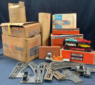
Large Group Lot Lionel Trains & TracksThe Benefit Shop Foundation Inc.4.3(2.9k)See Sold PriceFeb 28, 2024
Rand McNally & Co's New Ideal State and County Survey and Atlas 1911North American Artifact Auctions4.7(198)See Sold PriceApr 20, 2024
[LITHOGRAPHY]. [TOBACCO]. A Large Group of 70 Cigar/Tobacco...Potter & Potter Auctions4.6(545)See Sold PriceMar 07, 2024
[CHICAGO CRIME]. A large group of 66 explicit autopsy and c...Potter & Potter Auctions4.6(545)See Sold PriceMar 07, 2024
[MAP]. NICHOLLS, Sutton (1668-1729). An Epitome of Sr. Will...Potter & Potter Auctions4.6(545)See Sold PriceMar 07, 2024
1736 LARGE MAP OF SILESIA POLAND OPPAVIENSIS antique 25 by 34 3/4"Jasper524.5(9.9k)See Sold PriceFeb 27, 2024
1736 LARGE MAP OF SILESIA POLAND KARNOVIENSIS antique 25 x 4 3/4" Duchy of KrnovJasper524.5(9.9k)See Sold PriceFeb 27, 2024
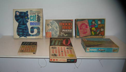
Large group of vintage games and puzzlesBaker's Antiques and Auctions3.2(471)See Sold PriceFeb 24, 2024
Birmingham.- Commercial map.- Smith (J. Pigott) To the Right Honourable William Earl of Dartmouth...Forum Auctions4.3(53)See Sold PriceFeb 29, 2024
Very Large Group of Art Collected by Graciela KartofelCapsule Auctions4.6(168)See Sold PriceFeb 28, 2024
Large group of vintage games and puzzlesBaker's Antiques and Auctions3.2(471)See Sold PriceMar 03, 2024


![[LITHOGRAPHY]. [TOBACCO]. A Large Group of 70 Cigar/Tobacco... (1 of 4)](https://p1.liveauctioneers.com/928/318880/171361089_1_x.jpg?height=282&quality=70&version=1707501302)
![[CHICAGO CRIME]. A large group of 66 explicit autopsy and c... (1 of 5)](https://p1.liveauctioneers.com/928/318880/171361261_1_x.jpg?height=282&quality=70&version=1707501302)
![[MAP]. NICHOLLS, Sutton (1668-1729). An Epitome of Sr. Will... (1 of 1)](https://p1.liveauctioneers.com/928/318880/171361281_1_x.jpg?height=282&quality=70&version=1707501302)