ATLAS of ANTIENT GEOGRAPHY by SAMUEL BUTLER 1843John McInnis Auctioneers,LLC4.5(494)See Sold PriceFeb 24, 2024
18TH C. ANTIQUE MAP: FRENCH & INDIAN WAR, FRAMEDThomaston Place Auction Galleries4.4(386)See Sold PriceFeb 24, 2024
Rand McNally Railroad Map Cabinet w/ 21 Railroad MapsRail & Road Auctions4.6(165)See Sold PriceMar 08, 2024
Keith Haring - Ink on New York Map, Best Buddies, Inscribed, Signed, and DatedSapphire Auction Gallery3.9(67)See Sold PriceMar 02, 2024
LATE 17TH C. FRENCH MAP OF THE NEW WORLD BY ALEXIS-HUBERT JAILLOT (1632-1712)Thomaston Place Auction Galleries4.4(386)See Sold PriceFeb 24, 2024
Central Railroad of New Jersey Map of Sandy Hook Route-ca. 1903JM Hobby Supply and Railroad Artifact Auctions4.4(126)See Sold PriceFeb 24, 2024
Lot of Six Mixed Atlas Box Cars-HO Scale-New in BoxJM Hobby Supply and Railroad Artifact Auctions4.4(126)See Sold PriceFeb 25, 2024
Rand McNally/Santa Fe Railroad Map of Iowa-1912JM Hobby Supply and Railroad Artifact Auctions4.4(126)See Sold PriceFeb 24, 2024
NICOLAES VISSCHER (NETHERLANDS, 1618-1709) MAP OF THE NEW WORLDThomaston Place Auction Galleries4.4(386)See Sold PriceFeb 24, 2024
17TH C. WORLD MAP BY NICOLAES VISSCHER (NETHERLANDS, 1618-1709)Thomaston Place Auction Galleries4.4(386)See Sold PriceFeb 24, 2024
Lot of Six Mixed Atlas Cabooses-HO Scale-New in BoxJM Hobby Supply and Railroad Artifact Auctions4.4(126)See Sold PriceFeb 25, 2024
Sold3pc 18th Century Maps of Macao & Islands- Cook etc3pc 18th Century Maps of Macao & Islands. Includes J.V. Schley 'Carte des Isles de le Riviere de Canton' c. 1750 (11.25x15''), James Cook 'Sketch Typa and Macao' 1785 (11.25x9''), and Nicolas Bellin 'See Sold Price
Sold(2) MID 19TH CENTURY MAPS OF THE AMERICASBerghaus' Physikal Atlas / Perthes; (1) 1850 Map of Central America, including Pacific Islands [Cook Islands, Hawaii, Galapagos, etc.], depicting general topography; (1) 1850 map of South America, depSee Sold Price
SoldCartography - early 18th century and later county andCartography - early 18th century and later county and road maps of Nottingham and Nottinghamshire, various; Cheshire; one-page World maps, including Africa, Magdalen Islands, etc; military; various daSee Sold Price
Sold18th Century Map of Macao, 1796,by George Nicol, being a map of the city and harbour of Macao, dated April 12th 1796. 86cm x 55cmSee Sold Price
SoldJohn Siller 18th Century Handcolored Map, "Island"Island of Guernsey" overall with text 6 1/2" x 9".See Sold Price
SoldJefferys' 18th Century Map of the Island ofA General chart of the Island of Newfoundland... Thomas Jefferys (c. 1719 – 1771). Copperplate engraved map handcolored in outline. London: Sayer & Bennett, 1776. 21 1/2 x 29 inches sheet. ImportantSee Sold Price
Unique Late 18th-century Manuscript Map of the IslandReal Arsenal de Mahon, Ano 98. Manuscript map in watercolor and ink on paper. 16 x 22 inches sheet, 24 x 31 inches framed. Unique Late 18th-century Manuscript Map of the Island of MenorcaSee Sold Price
Vintage C.I.A. Map of HungaryCirca 1973, together with a reproduction 18th century map of the Virgin Islands, both framed. Largest: approx. 26 1/2" x 22 1/2" including frame.See Sold Price
SoldTwo 18th Century French Caribbean Island Mapscirca 1760, copperplate engravings with outline color depicting Barbados and Grenada. Presented in wooden frames. DOA 13 x 10.75 in. From the Collection of Colette Gaudron, Southeast Asia & Chapel HilSee Sold Price
Sold18th Century Hand Colored Map of Long IslandThe map giving excellent detail of troops location and with good hand colored details. Good overall condition with some slight yellowing to paper consistent with age. The piece has no watermark and haSee Sold Price
Sold"Terra FIrma and Caribbe Islands", Emanuel Bowen"A New and Accurate Map of the Terra Firma and the Caribbe Islands", an 18th century map by Emanuel Bowen (1693-1767). An engraved and hand colored map in two pages with central fold crease, framed. 1See Sold Price
SoldPapua New Guinea Ceremonial Adze#328 32" adze, 18th-19th century from Mangaia, Cook Islands- entire legnth of staff incised with intricate geometric design topped with basalt blade.See Sold Price
THREE ANTIQUE 18TH C FRAMED MAPS: SPAIN, ENGLANDLot of three antique 18th century hand colored map engravings. Includes Balearic Islands, Spain, 1778, Antonio Zatta; Buckinghamshire, 1787, J. Cary; and Oxfordshire, 1787, J. Cary. The two smaller EnSee Sold Price
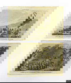
SoldNine Engravings Concerning the Exploration of PolyNine Engravings Concerning the Exploration of Polynesia by Captain James Cook, 18th century, three maps, three portraits, and various ceremonial scenes, matted, image size to 9 x 15 in.See Sold Price
Sold18th / 19th Century hand coloured map, the smaller18th / 19th Century hand coloured map, the smaller islands in the British ocean, including the Isle of Wight by Robert Morden, 14ins x 16ins, and another hand coloured map of SussexSee Sold Price
Old 18th Century World Map Displaying TracksOLD 18th CENTURY WORLD MAP DISPLAYING TRACKS of CAPTAIN COOK Engraved by T BROWN OLD 18th CENTURY WORLD MAP DISPLAYING TRACKS of CAPTAIN COOK Engraved by T BROWN Description Circa 1768-1787 Antique WoSee Sold Price
Map Normandy, Jersey and Guernsey.18th century British map "A General Chart of the Islands of Guernesey, Jersey, Serco, Herm, Jethou, and Alderney. " 18-1/2" x 26-1/2" plate size. Dobree of Guernfey, Agent to the Admiralty. Size 31" xSee Sold Price
SoldEmanuel Bowen 18th Century MapOrnamental title cartouche upper left "A New and Accurate Map of Great Britain & Ireland, together with their respective Islands &c. Drawn from Surveys, and the most approved Maps and Charts. The wholSee Sold Price
SoldFour 18th Century Maps of America.Four 18th Century Maps of America. A PLAN of the TOWN AND CHART of the HARBOUR of BOSTON Exhibiting a View of the Islands Castle Forts and Entrance into the said Harbour, 1775. Sight ht. 11 1/4, wd. 1See Sold Price
The Bermudas or Summer's Islands MapCopy of sheet from the West India Atlas, of the 18th Century. Map reprinted and hand colored in 1968 by The Meriden Gravure Barre Publishers. The Bermudas, or Summer's Islands. From a Survey by C. LemSee Sold Price
Early Caribbean Island Map PrintFrom the West India Atlas of the 18th Century, Map reprinted and hand colored in 1968 by the Meriden Gravure Company for Barre Publishers. Copy of 1775 map The Caribbee Islands The Virgin Island and tSee Sold Price
SoldJefferys' 18th Century Map of the Banks of NewfoundlandA chart of the Banks of Newfoundland... Drawn from Chabert, Cook and Flerieu...Thomas Jefferys (c. 1719 – 1771). Copperplate engraved map handcolored in outline. London: Sayer & Bennett, March, 1775See Sold Price
1789 Captain James Cook Life & Voyages Australia New Zealand Hawaii KippisSchilb Antiquarian Rare Books4.8(415)See Sold PriceMar 10, 2024
EARLY 18TH C. DUTCH CHART OF PACIFIC OCEAN BY FREDERIK DE WIT (1629-1706) WITH CALIFORNIA AS ANThomaston Place Auction Galleries4.4(386)See Sold PriceFeb 24, 2024
Lot of 7 drawings and watercolors. Portraits, classical scenes, sculptural, etc. 18th/19thTremont Auctions4.6(292)See Sold PriceFeb 25, 2024
Large lot of assorted prints. 18th-20th century. To include: North American and other maps, CivilTremont Auctions4.6(292)See Sold PriceFeb 25, 2024
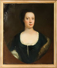
18th Century Continental School Portrait of a LadyNadeau's Auction Gallery4.7(398)See Sold PriceFeb 24, 2024
1849 Mitchell School ATLAS 24 MAPS America Holy Land France Africa Egypt AsiaSchilb Antiquarian Rare Books4.8(415)See Sold PriceMar 31, 2024
An early Dutch hand colored engraving map by Georg Balthasar Probst (1732-1801)Ostantix Auctions4.3(9)See Sold PriceFeb 27, 2024
Willem Blaeu, Etc. 17th C. Antiquarian Maps, 2Auctions at Showplace4.5(723)See Sold PriceMar 17, 2024
18th Century English School, Portrait of a Lady, Oil on Canvas PaintingHoch LTD.4.6(70)See Sold PriceFeb 25, 2024
RHODE ISLAND CHIPPENDALE SLANT FRONT DESK.Amelia Jeffers, Auctioneers & Appraisers4.6(97)See Sold PriceMar 08, 2024
After Beilby & Bewick, 18th century, Engravings, Cook's Voyages - An Offering before Captain Cook inClaydon Auctioneers Ltd4.3(125)See Sold PriceFeb 26, 2024
1683 Sanson Map of the Caribbean -- Les Isles Antilles, &c Entre Lesquelles sont les Lucayes, et lesJasper524.5(9.7k)See Sold PriceFeb 27, 2024
Le Canal de Mosambique, l'Isle de Madagascar… Mozambique. Africa. BONNE 1788 mapJasper524.5(9.7k)See Sold PriceFeb 28, 2024
WEST AFRICA. Guinea. Nigeria Ghana Benin Togo Sierra Leone. MALLET 1683 mapJasper524.5(9.7k)See Sold PriceFeb 28, 2024
Le Canal de Mosambique, l'Isle de Madagascar… Mozambique. Africa. BONNE 1790 mapJasper524.5(9.7k)See Sold PriceFeb 28, 2024
Partie Occidentale de l’Afrique. West Africa coast Canary islands BONNE 1788 mapJasper524.5(9.7k)See Sold PriceFeb 28, 2024


![Antiquities Auction Catalogues [25] (1 of 1)](https://p1.liveauctioneers.com/1191/317887/170614345_1_x.jpg?height=282&quality=70&version=1706614110)