ATLAS of ANTIENT GEOGRAPHY by SAMUEL BUTLER 1843John McInnis Auctioneers,LLC4.6(504)See Sold PriceFeb 24, 2024
18TH C. ANTIQUE MAP: FRENCH & INDIAN WAR, FRAMEDThomaston Place Auction Galleries4.4(389)See Sold PriceFeb 24, 2024
Rand McNally Railroad Map Cabinet w/ 21 Railroad MapsRail & Road Auctions4.6(165)See Sold PriceMar 08, 2024
Keith Haring - Ink on New York Map, Best Buddies, Inscribed, Signed, and DatedSapphire Auction Gallery4.1(67)See Sold PriceMar 02, 2024
LATE 17TH C. FRENCH MAP OF THE NEW WORLD BY ALEXIS-HUBERT JAILLOT (1632-1712)Thomaston Place Auction Galleries4.4(389)See Sold PriceFeb 24, 2024
Central Railroad of New Jersey Map of Sandy Hook Route-ca. 1903JM Hobby Supply and Railroad Artifact Auctions4.4(126)See Sold PriceFeb 24, 2024
Lot of Six Mixed Atlas Box Cars-HO Scale-New in BoxJM Hobby Supply and Railroad Artifact Auctions4.4(126)See Sold PriceFeb 25, 2024
Rand McNally/Santa Fe Railroad Map of Iowa-1912JM Hobby Supply and Railroad Artifact Auctions4.4(126)See Sold PriceFeb 24, 2024
NICOLAES VISSCHER (NETHERLANDS, 1618-1709) MAP OF THE NEW WORLDThomaston Place Auction Galleries4.4(389)See Sold PriceFeb 24, 2024
17TH C. WORLD MAP BY NICOLAES VISSCHER (NETHERLANDS, 1618-1709)Thomaston Place Auction Galleries4.4(389)See Sold PriceFeb 24, 2024
Lot of Six Mixed Atlas Cabooses-HO Scale-New in BoxJM Hobby Supply and Railroad Artifact Auctions4.4(126)See Sold PriceFeb 25, 2024
Vintage C.I.A. Map of HungaryCirca 1973, together with a reproduction 18th century map of the Virgin Islands, both framed. Largest: approx. 26 1/2" x 22 1/2" including frame.See Sold Price
Hungary. Romania. Jugoslavia / Yugoslavia. Bulgaria. Balkans. TIMES 1956 mapTITLE/CONTENT OF MAP: 'Hungary // Romania // Jugoslavia' DATE PRINTED: 1956 IMAGE SIZE: Approx 47.0 x 59.5cm, 18.5 x 23.5 inches (Large); Please note that this is a folding map. TYPE: Vintage colouredSee Sold Price
EUROPE/HOLY ROMAN EMPIRE. at the time of the Third Crusade 1190 1902 old mapTITLE/CONTENT OF MAP: 'Hungary // Romania // Jugoslavia' DATE PRINTED: 1956 IMAGE SIZE: Approx 47.0 x 59.5cm, 18.5 x 23.5 inches (Large); Please note that this is a folding map. TYPE: Vintage colouredSee Sold Price
SoldWW1 EASTERN FRONT.Romania Hungary Ukraine MoldovaTITLE/CONTENT OF MAP: 'Eastern Front (South)' DATE PRINTED: 1920 IMAGE SIZE: Approx 22.0 x 32.5cm, 8.5 x 12.75 inches (Large) TYPE: Vintage colour map; Scale 1:3,000,000 CONDITION: Good; suitable forSee Sold Price
EUROPE IN 1740. Ottoman Empire. Kingdom of Poland. Hungary 1917 old mapTITLE/CONTENT OF MAP: 'Europe in 1740' DATE PRINTED: 1917 IMAGE SIZE: Approx 17.5 x 23.5cm, 6.75 x 9.25 inches (Medium); Please note that this is a folding map. TYPE: Vintage colour map CONDITION: GooSee Sold Price
International Fishing Congress and World CupArtist: Fery, Antal. 1967. cca. 70 x 50 cm. Vintage poster. Paper, offset. Antal Fery combined the logo of the international organization for sport fishing with a huge hook and Hungary's map. With thiSee Sold Price
CZECHOSLOVAKIA, AUSTRIA & HUNGARY. Central Europe post WW2 borders 1947 mapTITLE/CONTENT OF MAP: 'Czechoslovakia, Austria and Hungary' DATE PRINTED: 1947 IMAGE SIZE: Approx 23.0 x 35.0cm, 9 x 13.75 inches (Large) TYPE: Vintage colour atlas map CONDITION: Good; suitable for fSee Sold Price
SoldVintage Texas MapVintage map of Texas, framed frame: 17 x 19" Condition: Foxing Provenance: The collection of former CIA Director R. James Woosley & Nancye Miller (San Antonio, Texas) We happily provide seamleSee Sold Price
SoldMyra Z Barnes: Vintage Map French Quarter, New OrleansTitle/Content of Map: 1942 Myra Z Barnes Map of French Quarter, New Orleans -- Le Vieux Carre de la Nouvelle Orleans Date Printed: 1942 Cartographer: Myra Z Barnes Size: 20.5 X 30.8 A very attractiveSee Sold Price
SoldAN VINTAGE MAP, "Texas and Indian Territory," SECONDAN VINTAGE MAP, "Texas and Indian Territory," SECOND QUARTER 20TH CENTURY, color engraving on paper, showing counties, cities, rail lines, and rivers. 13.25" x 10.125"See Sold Price
SoldVINTAGE MAP OF BERMUDADimensions: (Frame) H 18.25" x W 23" Condition: Some light frame wear. Some toning and slight creases to map.See Sold Price
SoldA VINTAGE MAP, "1852 Map of the State of Texas," MIDA VINTAGE MAP, "1852 Map of the State of Texas," MID 20TH CENTURY, ink on paper, "Published 1961, by Highlands Historical Press, Facsimile of the Original, Dallas, Texas." 8" x 11"See Sold Price
Sold3 Vintage maps1, Vintage maps topographical map of North and South Carolina, a large portion of Georgia and part of a joining states XL plate 1966, 2, Village map Panera of the sea of war Birdseye view of North CarSee Sold Price
SoldVintage map in gilt frame of New England. Site sizeVintage map in gilt frame of New England. Site size H:9" W:12.5"See Sold Price
SoldFramed Vintage Map of Bedford, New YorkMap is matted and set behind glass in wood frame. Measures approx 22.25 inches in height by 19.5 inches in width with frame. Some surface wear of frame, some minor toning of map and matting. DecorativSee Sold Price
SoldVintage Map of Florida Table Linenvintage map of Florida table linen, stains to cloth, cloth shows a net pattern with a map of Florida as well as a border of pictures that show the highlights of the state, Vintage table cloth, vintageSee Sold Price
Vintage Map Of Long IslandVintage map of Long Island. Matted and framed. Size 30 1/4 x 34 1/4 inches. Please note that this lot has a confidential reserve. When you leave a bid in advance of the auction, submit your maximum. JSee Sold Price
SoldVintage Map, A Perfect Description of the NorthernmostVintage Map, "A Perfect Description of the Northernmost Coastes of England..." engraving with hand-coloring with text verso, overall (with frame): 13.5"h x 21"wSee Sold Price
SoldA VINTAGE MAP, "Texas," CIRCA 1890,A VINTAGE MAP, "Texas," CIRCA 1890, engraving on paper, a page fragment from an atlas, plate 68, with view of the Panhandle, lacking Jeff Davis County, within a geometric border, attributedSee Sold Price
SoldVintage Map Jamestown Williamsburg and YorktownVintage Map Print of Jamestown Williamsburg and Yorktown. Appears to be lithograph but not inspected outside of the frame. Depicts ‘A Part of Virginia Showing Jamestown Williamsburg and Yorktown witSee Sold Price
SoldVINTAGE MAP OF MEXICOVINTAGE MAP OF MEXICO. Height: 33 & 22 in. by Width: 26 1/2 & 16 in.See Sold Price
SoldVINTAGE MAP OF THE UNITED STATESVintage map of the United States, published by N. & S.S. Jocelyn of New Haven Connecticut. Due to the map ending at Oregon we can date this to ca. 1830s. A few trivial tears at the folds, else fine. OSee Sold Price
Vintage County Map Of NY State Plate EngravingThe Benefit Shop Foundation Inc.4.3(2.9k)See Sold PriceFeb 28, 2024
West Africa by Arrowsmith & Lewis 1812 old antique vintage map plan chartJasper524.5(9.8k)See Sold PriceFeb 28, 2024
AFRICA. Posesione Espanola Costa Occidental Bioko Rio Oro Fernando Po 1913 mapJasper524.5(9.8k)See Sold PriceFeb 28, 2024
Western Sahara. Africa 1885 old antique vintage map plan chartJasper524.5(9.8k)See Sold PriceFeb 28, 2024
AFRICA. Africa. Britannica 9th edition 1898 old antique vintage map plan chartJasper524.5(9.8k)See Sold PriceFeb 28, 2024
AFRICA. Political Map of showing International Boundaries 1936 old vintageJasper524.5(9.8k)See Sold PriceFeb 28, 2024
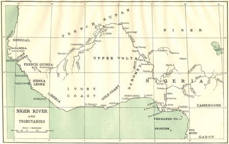
AFRICA. Niger River and Tributaries 1936 old vintage map plan chartJasper524.5(9.8k)See Sold PriceFeb 28, 2024
Showers of Red Dust. Africa. Sahara 1886 old antique vintage map plan chartJasper524.5(9.8k)See Sold PriceFeb 28, 2024
Africa by Arrowsmith & Lewis 1812 old antique vintage map plan chartJasper524.5(9.8k)See Sold PriceFeb 28, 2024
Vintage Map of Roman Forum - Vatican City - Versailles parkProverde Auctions4.3(3)See Sold PriceFeb 28, 2024
Vintage Map - På Vakts Krigskarta över Norden / On Vakt's war map of the Nordic region, SecondProverde Auctions4.3(3)See Sold PriceFeb 28, 2024
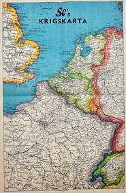
Vintage Map - Krigskarta - War Map - Second World War, published 1940Proverde Auctions4.3(3)See Sold PriceFeb 28, 2024
California Vintage Maps & Brochures (44 Pcs)Grant Zahajko Auctions, LLC4.7(1k)See Sold PriceMar 06, 2024
Colorado Vintage Maps & Travel Brochures (76 Pcs)Grant Zahajko Auctions, LLC4.7(1k)See Sold PriceMar 06, 2024
Framed Vintage Map Of Le Port Au Prince In The Island Of Santo DomingoRapid Estate Liquidators and Auction Gallery4.5(1.1k)See Sold PriceMar 01, 2024
Vintage 1920s Rand McNally Auto Trails MapThe Benefit Shop Foundation Inc.4.3(2.9k)See Sold PriceMar 20, 2024
Vintage Zsolnay Hungary Artist Signed Floral Porcelain VaseLodestar Auctions4.6(396)See Sold PriceJun 28, 2024