SoldJohn Siller 18th Century Handcolored Map, "Island"Island of Guernsey" overall with text 6 1/2" x 9".See Sold Price
Sold18th C Map of Florence, Hand Colored EngravingFramed 18th century map of Florence, hand colored engraving. Provenance: John's Island, Vero Beach, Florida.See Sold Price
Sold18th Century Hand Colored Map of Long IslandThe map giving excellent detail of troops location and with good hand colored details. Good overall condition with some slight yellowing to paper consistent with age. The piece has no watermark and haSee Sold Price
THREE ANTIQUE 18TH C FRAMED MAPS: SPAIN, ENGLANDLot of three antique 18th century hand colored map engravings. Includes Balearic Islands, Spain, 1778, Antonio Zatta; Buckinghamshire, 1787, J. Cary; and Oxfordshire, 1787, J. Cary. The two smaller EnSee Sold Price
SoldJOHN LODGE (BRITISH, 18TH CENTURY) REVOLUTIONARY WARJOHN LODGE (BRITISH, 18TH CENTURY) REVOLUTIONARY WAR MAP hand-colored engraving on laid paper, "A Map and Chart of those Parts of the Bay of Chesapeak York and James Rivers which are at present The SeSee Sold Price
SoldMounted 18TH CENTURY ENGRAVING OF POCKLINGTONS ISLANDDetails: 18th Century hand-colored engraving after 1783 map of Pocklington's Island.Mounting measures 15" w by 14" h, containing engraving which measures 11" w by 9" h. "Derwent Island was owned by FSee Sold Price
Sold18th century hand colored map, titled "A New andAccurate Map of the Colony of Massachusetts Bay in North America from a Late Survey". Published in London, 1780, by John Hinton. Sight size 10 3/8" x 12 7/8". In a modern burlwood frame with multi-laySee Sold Price
Sold18th Century Hand Colored Map of HungaryPublished: Ca. 1720, London. Author: John Senex Hand Colored map framed under glass. 22.5" W x 18.5" HSee Sold Price
Spanish Frigate La Ventura in the ice at Cape Horn18th Century Hand-colored map with astrological chart under Plexiglas Unsigned Sight of largest: 8.5" H x 14.75" W Provenance: Property from the Kelton collection. Notes: A print of the astroloSee Sold Price
SoldFramed 18th Century British Hand Colored Road MapFramed 18th Century British Hand Colored Road Map. This "strip" map features Glocestershire and Warwickshire, originally from the Britannia Depicta or Ogilby Improved Atlas's. Circa 1720 by John OwenSee Sold Price
Early Caribbean Island Map PrintFrom the West India Atlas of the 18th Century, Map reprinted and hand colored in 1968 by the Meriden Gravure Company for Barre Publishers. Copy of 1775 map The Caribbee Islands The Virgin Island and tSee Sold Price
Early Caribbean Island Map PrintFrom the West India Atlas of the 18th Century, Map reprinted and hand colored in 1968 by the Meriden Gravure Company for Barre Publishers. Copy of 1775 map The Caribbee Islands The Virgin Island and tSee Sold Price
The Bermudas or Summer's Islands MapCopy of sheet from the West India Atlas, of the 18th Century. Map reprinted and hand colored in 1968 by The Meriden Gravure Barre Publishers. The Bermudas, or Summer's Islands. From a Survey by C. LemSee Sold Price
The Bermudas or Summer's Islands MapCopy of sheet from the West India Atlas, of the 18th Century. Map reprinted and hand colored in 1968 by The Meriden Gravure Barre Publishers. The Bermudas, or Summer's Islands. From a Survey by C. LemSee Sold Price
SoldMatthaus Seutter (German, 1678-1757) 'MississippiMatthaus Seutter (German, 1678-1757) 'Mississippi Bubble Map' Engraving 18th century hand-colored copper engraving depicting the French colonies briefly involved in John Law's Mississippi (trading) CoSee Sold Price
SoldPeriod map, John OgilbyFramed hand colored period map, ''The Road from Oxford to Chichester'', by John Ogiley (British, 18th century), overall: 20.75''h x 23.75''hSee Sold Price
Sold18TH CENTURY MAP OF FRANCE18TH CENTURY MAP OF FRANCE, hand-colored, titled "A NEW MAP OF FRANCE, DIVIDED into DEPARTMENTS, as decreed by the NATIONAL ASSEMBLY, MDCCXC. FROM THE LATEST AUTHORITIES, By JOHN CARY, Engraver. 1799"See Sold Price
SoldManuscript Map of St. KittsPARKER, John (18th century).A contracted Plan of the Estate of Crisp. Molyneux Esq. at Nichola Town in the Island of St. Christopher. Surveyed June 1752 by Jas. Milliken.Manuscript map in pen and inkSee Sold Price
Manuscript Map of Sugar Plantations on St. KittsPARKER, John (18th century). A contracted Plan of the Estate of Crisp. Molyneux Esq. at Nichola Town in the Island of St. Christopher. Surveyed June 1752 by Jas. Milliken. Manuscript map in pen and inSee Sold Price
Sold18th Century Hand Colored Engravings18th century hand colored engravings, months of the year, lot of 12, 13" x 8" unframed, 21" x 15" framed. Provenance: John's Island, Vero Beach, Florida.See Sold Price
5 - 17/18 C Etchings: Maps, Cities, Isfahan, ect.5 - 17th/18th Century Etchings of Maps, Cities, Battles: an Italian hand-colored folio map with center fold of the Island of Sardinia, "Isola Di Sardegna", A detailed view of Naghsh-e Jahan Square inSee Sold Price
Sold18thc Hand Colored View Of the Colosseum18th century hand colored view of the Colosseum, Navmachia Domitiani. Having custom burlwood frame and matting, Giovanni Baccani of Florence, 30" x 35". Provenance: John's Island, Vero Beach, Florida.See Sold Price
Soldmap, Cardiganshire, John Owen and Emanuel BowenFramed two-sided hand colored engraved map of Cardiganshire, Wales, surmounted by a decorative cartouche, by John Owen and Emanuel Bowen, (British, 18th century), road map on verso from London to BeacSee Sold Price
SoldLOT (2) HAND COLORED ENGRAVED MAPSLOT (2) HAND COLORED ENGRAVED MAPS INCLUDING SAINT DOMINQUE AND THE ISLANDS OF GUADELOUPE, SIGNED M. BONNE (FRENCH 18TH CENTURY). PLATES 8 1/4 X 12 1/2" & 9 X 13"; SHEETS 10 X 14 1/2" & 9 3/4 X 15 3/4See Sold Price
LATE 18TH C. VERY LARGE CHART OF NORTHEAST CANADA BY DES BARRES (1721-1824), 1780, FRAMEDThomaston Place Auction Galleries4.4(393)See Sold PriceFeb 24, 2024
EARLY 18TH C. DUTCH CHART OF PACIFIC OCEAN BY FREDERIK DE WIT (1629-1706) WITH CALIFORNIA AS ANThomaston Place Auction Galleries4.4(393)See Sold PriceFeb 24, 2024
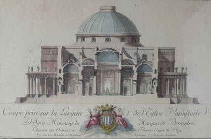
Charles Dupuis French 18th century, Pair Hand Colored Engravings, ArchitecturalGlobal Auctions Company4.3(36)See Sold PriceMar 03, 2024
An early Dutch hand colored engraving map by Georg Balthasar Probst (1732-1801)Ostantix Auctions4.4(11)See Sold PriceFeb 27, 2024
17th Century Hand Colored Engraved Map of GermanyGlobal Auctions Company4.3(36)See Sold PriceMar 03, 2024
18th Century Hess Germany Hand colored Engraved MapGlobal Auctions Company4.3(36)See Sold PriceMar 03, 2024
18th century MAP of ARMENIA GEORGIA NATOLIA BLACK SEA ASIA MINOR antiqueJasper524.5(9.9k)See Sold PriceFeb 27, 2024
La Basse-Guinée… Loango, Congo, AngoIa & Benguela Southern Africa BONNE 1790 mapJasper524.5(9.9k)See Sold PriceFeb 28, 2024
États du Roi de Maroc… d’Alger, Tunis & Tripoli. North Africa. BONNE 1790 mapJasper524.5(9.9k)See Sold PriceFeb 28, 2024
Le Canal de Mosambique, l'Isle de Madagascar… Mozambique. Africa. BONNE 1788 mapJasper524.5(9.9k)See Sold PriceFeb 28, 2024
Royaumes, Etats et Pays de la Haute Guinée. Gulf of Guinea. BONNE 1788 old mapJasper524.5(9.9k)See Sold PriceFeb 28, 2024
Le Royaume d’Adel… Ajan & Zanguebar. Adal Ajuran. Kenya Tanzania. BONNE 1788 mapJasper524.5(9.9k)See Sold PriceFeb 28, 2024
Le Canal de Mosambique, l'Isle de Madagascar… Mozambique. Africa. BONNE 1790 mapJasper524.5(9.9k)See Sold PriceFeb 28, 2024
Partie Occidentale de l’Afrique. West Africa coast Canary islands BONNE 1788 mapJasper524.5(9.9k)See Sold PriceFeb 28, 2024
Le Royaume d’Adel… Ajan & Zanguebar. Adal Ajuran. Kenya Tanzania. BONNE 1790 mapJasper524.5(9.9k)See Sold PriceFeb 28, 2024
États du Roi de Maroc… d’Alger, Tunis & Tripoli. North Africa. BONNE 1788 mapJasper524.5(9.9k)See Sold PriceFeb 28, 2024
La Basse-Guinée… Loango, Congo, AngoIa & Benguela Southern Africa BONNE 1788 mapJasper524.5(9.9k)See Sold PriceFeb 28, 2024
Egypte, Nubie et Abissinie. Egypt, Nubia & Abyssinia. Sudan. BONNE 1788 mapJasper524.5(9.9k)See Sold PriceFeb 28, 2024
18th Century Hand Colored Engraving. "Minnebroeders Klooster"Clark's Auction Company4.6(443)See Sold PriceMar 03, 2024
Late 18th century map of England and Wales sampler and two printsFellows4.3(159)See Sold PriceMar 05, 2024
John Hinton "The Tamarind" Hand-Colored EngravingAuctions at Showplace4.6(740)See Sold PriceApr 16, 2024