208: [France]. 2 Levassuer Maps From Atlas National Il[France]. 2 Levassuer Maps From Atlas National Illustre [c1852]. ++ Dept. De L'Isere. ++ Dept. Du Lot. Each matted in gilt frame; approx. 20 x 26 inches. Moderate foxing and soiling, else very good inSee Sold Price
Victor Levasseur Cartographer Paris, France Two (2Victor Levasseur Cartographer Paris, France Two (2) 19th Century Framed Maps "Dept d'Eure et Loir" and "Dept de la The Vienne" Circa 1850. Atlas National Illustre. Very Good Condition. Measures 12 IncSee Sold Price
Monin, V 1833 Maps (2) Guadeloupe & Reunion"La Guadeloupe" and "Ile Bourbon" Steel Engraved Maps Published 1833, Paris for "Petit Atlas National des départements de la France et de ses colonies" by V. Monin. Paper Size: 12.5 x 10 inch (32 x 2See Sold Price
Monin, V 1833 Maps (2) Guadeloupe & Reunion"La Guadeloupe" and "Ile Bourbon" Steel Engraved Maps Published 1833, Paris for "Petit Atlas National des départements de la France et de ses colonies" by V. Monin. Paper Size: 12.5 x 10 inch (32 x 2See Sold Price
Sold2 framed map book plates2 framed map book plates including Map of France, Spain and Portugal, c. 1860; & Dept. De L'Isere from Atlas National Illustre. Foxing; creases. Largest measures 18 inches x 23 inches.See Sold Price
2 framed map book plates2 framed map book plates including Map of France, Spain and Portugal, c. 1860; & Dept. De L'Isere from Atlas National Illustre. Foxing; creases. Largest measures 18 inches x 23 inches.See Sold Price
SoldCharle & Darmet Map of France, SieneCHARLE et DARMET (19th Century). Siene. Engraved map with original hand color. Paris, 1835 from Nouvel Atlas National de la France. 17 1/2" x 22 1/2" sheet.See Sold Price
SoldCharle & Darmet Map of France, Pas de CalaisCHARLE et DARMET (19th Century). Pas de Calais. Engraved map with original hand color. Paris, 1835 from Nouvel Atlas National de la France. 17 1/2" x 22 1/2" sheet.See Sold Price
SoldCharle & Darmet Map of France, CorseCHARLE et DARMET (19th Century). Corse. Engraved map with original hand color. Paris, 1835 from Nouvel Atlas National de la France. 17 1/2" x 22 1/2" sheet.See Sold Price
France, Divided Into Departments; Agreable To theTitle: France, Divided Into Departments; Agreable To the Decrees of the National Assembly. Cartographer: GRIDLEY, sc. Publisher: THOMAS & ANDREWS Size: 7.2Height - 8.5Width From Volume 2 of Morse's AmSee Sold Price
2 early French maps "Atlas National Illustre" exce2 early French maps "Atlas National Illustre" excellent condition, 12" x 17" sight.See Sold Price
Sold[France] Maps from Levasseur’s 'Atlas National'[France] 7 Maps from an edition of Levasseur’s “Atlas National Illustre Des 86 Departements et Possessions de la France,” [1845 – 1860s]. Seven hand colored 19th century prints from the 'AtlasSee Sold Price
LevasseurTwo (2) Maps from Levasseur's Atlas National Illustre. These measure approximately 22 in. x 14.5 in. and boards measure 23 in. x 16 in. If lot is absent of a condition report one may be requested viaSee Sold Price
France.- Levasseur (Victor) 21 maps from: AtlasFrance.- Levasseur (Victor) 21 maps from: Atlas National Illustré des 86 Départments et des Possessions, engravings on wove paper, some outline hand-colouring, each sheet approx. 365 x 530 mSee Sold Price
SoldLevasseur: 14 maps, elaborate color border.[France]. 14 Maps of French departments, from Atlas National Illustre. V. [Victor] Levasseur, engraved by Laguillermie and Rainaud. Paris: Parcheminerie, c.1850s. 15 7/8 x 10 5/8. Color outline to mapSee Sold Price
SoldA Collection of Five Hand-Painted Engravings, 19thA Collection of Five Hand-Colored Engravings, 19th Century, Depicting maps of France from the Atlas National Illustre series. Framed dimensions: h: 20.5 x w: 24 in.See Sold Price
Sold33 maps from Levasseur’s “Atlas National Illustre"[France] 33 Maps from an edition of Levasseur’s “Atlas National Illustre Des 86 Departements et Possessions de la France,” [1845 – 1860s]. The maps show the political boundaries, towns, and roSee Sold Price
SoldSet of Six Maps of France, 1854A Set of Six Maps of France , from the Atlas National Illustre' des 86 Departements et des Possessions de la France, by V. Levasseur, published by A. Combette, 1854, hand-colored engraved maps surrounSee Sold Price
Sold[Maps] Atlas National, 1856Levasseur, V[ictor]. ATLAS NATIONAL, ILLUSTRE DES 86 DEPARTMENTS ET DES POSSESSIONS DE LAS FRANCE…. Paris: Combette, 1856. Folio ( 14.25" x 10.5".) Complete with engraved double-page title and tableSee Sold Price
SoldJan Jansson Early Map Views France (2)Early maps: Jan Jansson. Calais and Lyon. (2) Map Views in France. Hand-colored engravings. From Theatrum exhibens celebriores Galliae et Helvetiae. Amsterdam, C. 1650s. 19" x 23".See Sold Price
Sold[Literature - France] 2 Volumes Memoirs of Joseph[Literature - France] 2 Volumes Memoirs of Joseph Fouche,' Napoleon's Minister of Police, in Two Volumes, Fine Binding Fouché, Joseph. The Memoirs of Joseph Fouché, Duke of Otranto, Minister of theSee Sold Price
SoldFrance.- Morgan (Sydney, Lady) France, 2 vol., fourthNO RESERVE France.- Morgan (Sydney, Lady) France, 2 vol., fourth edition, engraved musical notation, contemporary tree calf, gilt, spines gilt, rubbing to joints, 1818 § Thiébault (Baron) ThSee Sold Price
Sold2 maps: Speede. Rutlandshire... + Sanson ...France[England/France] 2 Maps. (1) Speede, John (British, 1552-1629). "Rutlandshire With Oukham And Stanford Her Bordering Neighbour Newly Described." John Sudbury and George Humbell, London, 1612. EnglishSee Sold Price
Sold2 Maps by Seutter incl: REGIO CANAAN SEU TERRA...[Israel/France] 2 Maps by Matthew Seutter. Double-page engraved map. Hand-colored. Slight foxing. Versos have a tape strip to center of upper and lower edge. On versos, c-fold glued or otherwise conseSee Sold Price
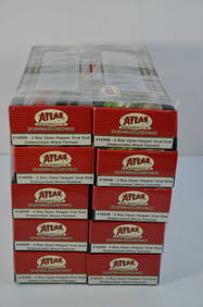
Chesapeake and Ohio RR 10-pack Atlas 2 Bay Open Hoppers-HO Scale-New in BoxJM Hobby Supply and Railroad Artifact Auctions4.4(126)See Sold PriceFeb 25, 2024
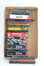
Nine Working GN/SOO/CNW/CP/CN/MILW DC Diesel Locomotives-HO ScaleJM Hobby Supply and Railroad Artifact Auctions4.4(126)See Sold PriceFeb 25, 2024
17TH C. ANTIQUE MAP SIEGE OF LA ROCHELLE, FRANCE, FRAMEDThomaston Place Auction Galleries4.4(386)See Sold PriceFeb 24, 2024
COVENS & MORTIER 1745 MAP OF THE GLOBEThomaston Place Auction Galleries4.4(386)See Sold PriceFeb 24, 2024
LATE 16TH C. MAP OF SCOTLAND BY MERCATOR, FRAMEDThomaston Place Auction Galleries4.4(386)See Sold PriceFeb 24, 2024
17TH C. MAP OF THE BERKSHIRES BY JOHN SPEED, FRAMEDThomaston Place Auction Galleries4.4(386)See Sold PriceFeb 24, 2024
ABRAHAM ORTELIUS (1527-1598) MAP OF ROMAN GAUL (FRANCE)Thomaston Place Auction Galleries4.4(386)See Sold PriceFeb 24, 2024
FRANK MARMINGTON c1910 National Gallery Canada Signed Engraving London St. Pauls 20" x 16"Luis Porretta Fine Arts4.3(10)See Sold PriceMar 02, 2024
1849 Mitchell School ATLAS 24 MAPS America Holy Land France Africa Egypt AsiaSchilb Antiquarian Rare Books4.8(421)See Sold PriceMar 31, 2024
Willem Blaeu, Etc. 17th C. Antiquarian Maps, 2Auctions at Showplace4.5(726)See Sold PriceMar 17, 2024
Putnam - First Map of the State of Ohio by Rufus PutnamTrillium Antique Prints & Rare Books4.5(30)See Sold PriceFeb 24, 2024
1822 MAP of NORTH & SOUTH AMERICA GEOGRAPHICAL STATISTICAL HISTORICAL antiqueJasper524.5(9.8k)See Sold PriceFeb 27, 2024
Herman Moll A New Map of Ye North Parts of AmericaWillow Auction House4.5(283)See Sold PriceMar 14, 2024


![208: [France]. 2 Levassuer Maps From Atlas National Il First Image](https://p1.liveauctioneers.com/dist/images/placeholder.jpg?height=282&quality=95&width=282)
![208: [France]. 2 Levassuer Maps From Atlas National Il (1 of 0)](https://p1.liveauctioneers.com/dist/images/placeholder.jpg?height=282&quality=70)
![208: [France]. 2 Levassuer Maps From Atlas National Il First Image](https://p1.liveauctioneers.com/dist/images/placeholder.jpg?height=282&quality=1&width=282)


![[France] Maps from Levasseur’s 'Atlas National' (1 of 8)](https://p1.liveauctioneers.com/5755/138410/70196116_1_x.jpg?height=282&quality=70&version=1552767267)


![[Maps] Atlas National, 1856 (1 of 8)](https://p1.liveauctioneers.com/3532/129264/65744519_1_x.jpg?height=282&quality=70&version=1539223604)

![[Literature - France] 2 Volumes Memoirs of Joseph (1 of 3)](https://p1.liveauctioneers.com/46/113409/58240882_1_x.jpg?height=282&quality=70&version=1512492316)