ATLAS of ANTIENT GEOGRAPHY by SAMUEL BUTLER 1843John McInnis Auctioneers,LLC4.6(504)See Sold PriceFeb 24, 2024
18TH C. ANTIQUE MAP: FRENCH & INDIAN WAR, FRAMEDThomaston Place Auction Galleries4.4(389)See Sold PriceFeb 24, 2024
Rand McNally Railroad Map Cabinet w/ 21 Railroad MapsRail & Road Auctions4.6(165)See Sold PriceMar 08, 2024
Keith Haring - Ink on New York Map, Best Buddies, Inscribed, Signed, and DatedSapphire Auction Gallery4.1(67)See Sold PriceMar 02, 2024
LATE 17TH C. FRENCH MAP OF THE NEW WORLD BY ALEXIS-HUBERT JAILLOT (1632-1712)Thomaston Place Auction Galleries4.4(389)See Sold PriceFeb 24, 2024
Central Railroad of New Jersey Map of Sandy Hook Route-ca. 1903JM Hobby Supply and Railroad Artifact Auctions4.4(126)See Sold PriceFeb 24, 2024
Lot of Six Mixed Atlas Box Cars-HO Scale-New in BoxJM Hobby Supply and Railroad Artifact Auctions4.4(126)See Sold PriceFeb 25, 2024
Rand McNally/Santa Fe Railroad Map of Iowa-1912JM Hobby Supply and Railroad Artifact Auctions4.4(126)See Sold PriceFeb 24, 2024
NICOLAES VISSCHER (NETHERLANDS, 1618-1709) MAP OF THE NEW WORLDThomaston Place Auction Galleries4.4(389)See Sold PriceFeb 24, 2024
17TH C. WORLD MAP BY NICOLAES VISSCHER (NETHERLANDS, 1618-1709)Thomaston Place Auction Galleries4.4(389)See Sold PriceFeb 24, 2024
Lot of Six Mixed Atlas Cabooses-HO Scale-New in BoxJM Hobby Supply and Railroad Artifact Auctions4.4(126)See Sold PriceFeb 25, 2024
Monin, V 1833 Maps (2) Guadeloupe & Reunion"La Guadeloupe" and "Ile Bourbon" Steel Engraved Maps Published 1833, Paris for "Petit Atlas National des départements de la France et de ses colonies" by V. Monin. Paper Size: 12.5 x 10 inch (32 x 2See Sold Price
Monin, V 1833 Maps (2) Guadeloupe & Reunion"La Guadeloupe" and "Ile Bourbon" Steel Engraved Maps Published 1833, Paris for "Petit Atlas National des départements de la France et de ses colonies" by V. Monin. Paper Size: 12.5 x 10 inch (32 x 2See Sold Price
SoldMonin, V. 1833 Lot of 5 French Colony Maps. Reunion etcPlus Guadeloupe, Guyana, Alger, and Senegambie ou Senegal. Steel Engraved Maps Published 1833, Paris for "Petit Atlas National des départements de la France et de ses colonies" by V. Monin. Paper SizSee Sold Price
Monin, V 1833 Maps (3) Alger, Guyane, Sengal. Africa3 French Colony Maps. One of French Guiana, the others North and West Africa. Steel Engraved Maps Published 1833, Paris for "Petit Atlas National des départements de la France et de ses colonies" bySee Sold Price
Monin, V 1833 Maps (3) Alger, Guyane, Sengal. Africa3 French Colony Maps. One of French Guiana, the others North and West Africa. Steel Engraved Maps Published 1833, Paris for "Petit Atlas National des départements de la France et de ses colonies" bySee Sold Price
SoldMonin, V 1833 Lot of 3 French Department MapsIncl Vienne, Haute Vienne and Yonne. Steel Engraved Maps Published 1833, Paris for "Petit Atlas National des départements de la France et de ses colonies" by V. Monin. Paper Size: 12.5 x 10 inch (32See Sold Price
SoldMonin, V 1833 Lot of 5 French Department MapsVendee, Tarn et Garonne, Vaucluse, Vosges, and Var. Steel Engraved Maps Published 1833, Paris for "Petit Atlas National des départements de la France et de ses colonies" by V. Monin. Paper Size: 12.5See Sold Price
SoldMonin (Charles V.) OcéanieMonin (Charles V.) Océanie,large map of Australasia, with 2 inset maps of south east and south west Australia, titled above, engraved map with original hand-colouring in outline, 490 x 665mm.,See Sold Price
1839 Turkey. By MoninTitle/Content: 1839 Turkey. By Monin Date: 1839 Medium: Hand colored, engraved Dimensions: 17 1/2" x 12 1/2" Description: Map of Turkey. 1839. By V. Monin. Paris. Hand-colored, engraved. Good conditioSee Sold Price
Sold1833 ATLAS MAPS Cartography Navigation Voyages1833 ATLAS MAPS Cartography Navigation Voyages Illustrated French Petit Monin Charles V. Monin was a 19th-century French cartographer who was one of the first Europeans to print maps under the printinSee Sold Price
1839 Africa by MoninTitle/Content: 1839 Africa by Monin Date: 1839 Medium: Hand colored, engraved Dimensions: 17 1/2" x 12 1/2" Description: Map of Africa with interior unknown. 1839. By V. Monin. Paris. Hand-colored, enSee Sold Price
1839. Ancient France (Gaul) by MoninTitle/Content: 1839. Ancient France (Gaul) by Monin Date: 1839 Medium: Hand colored, engraved Dimensions: 17 1/2" x 12 1/2" Description: Map of Ancient France, GAUL. 1839. By V. Monin. Paris. Hand-colSee Sold Price
Sold2 MapsTwo engraved Maps. One an 1833 map entitled "North America, Sheet V, The Northwest and Michigan Territories" by Baldwin & Cradock and a 1783 map entitled "Carte Du Golfe Du Mexique…" by Dr. R. BernaSee Sold Price
SoldMAPS, 2, 19TH C., 12" X 16", CANADA & MICHIGANMAPS, TWO, 19TH C., 12" X 16", CANADA & MICHIGAN:Including 1 engraved by J. & C. Walker, "North America: Sheet V, The North West and Michigan Territories", published by Baldwin & Cradock, 1833, 12 1/2See Sold Price
India V.Publication Date: 1833-12-01 Title: India V. Cartographer: WALKER, J. & C. Publisher: Baldwin & Cradock/S.D.U.K. Height: 14 Width: 11.2 Includes Cutch, Sinde to Gujerat. Reserve: $35.00 Shipping:<See Sold Price
SoldHenri V 1833 - 1833 Essai 2 francs, 1833FRANCE Henri V 1833 - 1833 Essai 2 francs, 1833. Copper, MS65 RB.See Sold Price
SoldHenri V 1833 - 1833 Essai 2 francs, 1833FRANCE Henri V 1833 - 1833 Essai 2 francs, 1833. Copper, Maz 909, MS63 BN, 10g.See Sold Price
SoldMonin: Map of North America, 1833Map: 1833 Monin Map of North America -- Amerique Septentrionale dressee par N. Lorraine Pere, attache au Depot Gal. de la Guerre. Cartographer: C Monin Year / Place: 1833, Paris Map Dimensions: 10 x 1See Sold Price
SoldHenri V 1833 - 1833 Essai 1/2 Franc, 1833FRANCE Henri V 1833 - 1833 Essai 1/2 Franc, 1833. Silver, Maz 914, MS63, 2.5g.See Sold Price
SoldScarce hstory of Ceylon 1906Title: Sketches of Ceylon History Author: Arunachalam, P[onnambalam] Description: [4], 62, [blank leaf], v pp. With 2 maps (including frontispiece with hand coloring in outlin); 4 plates from photogrSee Sold Price
WWI WWII COLD WAR VIETNAM MAPS V MAIL ARMBAND LOTIncludes Philippines USAF Korean era cloth map, CL406, 2 V-Mail WWII packet of unused stationary and envelopes, East German scarf, C-47 and other plane drawings, WWII 48 star flag pillowcase, Civil DeSee Sold Price
Tardieu: Guadeloupe, 1825Title/Content of Map: Tardieu: Guadeloupe, 1825 Date Printed: 1825, Paris Cartographer: Ambroise Tardieu Size: 10 1/2" x 10 1/2" The Guadeloupe map from Tardieu's Atlas Geographique, Statistique et PrSee Sold Price
Tardieu: Guadeloupe, 1825Title/Content of Map: Tardieu: Guadeloupe, 1825 Date Printed: 1825, Paris Cartographer: Tardieu Size: 10 1/2" x 10 1/2" The Guadeloupe map from Tardieu's Atlas Geographique, Statistique et ProgressifSee Sold Price
Tardieu: Guadeloupe, 1825Title/Content of Map: Tardieu: Guadeloupe, 1825 Date Printed: 1825, Paris Cartographer: Ambroise Tardieu Size: 10 1/2" x 10 1/2" The Guadeloupe map from Tardieu's Atlas Geographique, Statistique et PrSee Sold Price
Grand Trunk Railroad Across the Continent Through Canada Book-1917JM Hobby Supply and Railroad Artifact Auctions4.4(126)See Sold PriceFeb 24, 2024
WILLEM JANSZOON BLAEU (NETHERLANDS, 1571-1638)Thomaston Place Auction Galleries4.4(389)See Sold PriceFeb 24, 2024
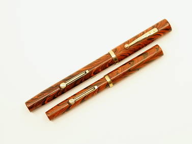
Waterman 52 & 52 1/2 V Red Ripple Fountain PensNorth American Pen Auctions LTD4.4(12)See Sold PriceFeb 24, 2024
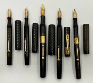
Waterman Ideal Hard Rubber Fountain Pen Lot (5)North American Pen Auctions LTD4.4(12)See Sold PriceFeb 24, 2024
Waterman Gold Filled & Ideal Safety Fountain PensNorth American Pen Auctions LTD4.4(12)See Sold PriceFeb 24, 2024
Viking Age Silver Sword Chape with Interlaced DesignTimeLine Auctions Ltd.4.6(182)See Sold PriceMar 05, 2024
Archaeological Books - Hilprecht - The Excavations in Assyria and BabyloniaTimeLine Auctions Ltd.4.6(182)See Sold PriceMar 06, 2024
Eight Gulf, Mobile & Ohio Railroad Playing Card Decks - Alton Route Map and LogoRail & Road Auctions4.6(165)See Sold PriceMar 08, 2024
Willem Blaeu, Etc. 17th C. Antiquarian Maps, 2Auctions at Showplace4.6(731)See Sold PriceMar 17, 2024
1856 ARCTIC EXPLORATIONS 2nd GRINNEL EXPEDITION 2 v. E.KANE antique ILLUSTRATEDJasper524.5(9.8k)See Sold PriceFeb 27, 2024
1709 GREEK BIBLE ILLUSTRATED w/ MAPS antique VELLUM BOUND Septuagint editionJasper524.5(9.8k)See Sold PriceFeb 27, 2024
Foulis.- Dryden (John, translator).- Virgilius Maro (Publius) The Works, 3 vol., Robert & AndrewForum Auctions4.3(53)See Sold PriceFeb 29, 2024
THE ANTIQUE ILLUSTRATED BOOK "1856 ARCTIC EXPLORATIONS: SECOND GIRNEL EXPEDITION 2" BY E. KANENY Elizabeth 4.3(85)See Sold PriceMar 03, 2024
Paul Louis Oudart - Set of 2 Antique Prints - Herpetology, Reptile - Bernard Germain Etienne De LaProverde Auctions4.3(3)See Sold PriceFeb 28, 2024