ATLAS of ANTIENT GEOGRAPHY by SAMUEL BUTLER 1843John McInnis Auctioneers,LLC4.5(505)See Sold PriceFeb 24, 2024
18TH C. ANTIQUE MAP: FRENCH & INDIAN WAR, FRAMEDThomaston Place Auction Galleries4.4(393)See Sold PriceFeb 24, 2024
Rand McNally Railroad Map Cabinet w/ 21 Railroad MapsRail & Road Auctions4.6(165)See Sold PriceMar 08, 2024
Keith Haring - Ink on New York Map, Best Buddies, Inscribed, Signed, and DatedSapphire Auction Gallery4.1(67)See Sold PriceMar 02, 2024
LATE 17TH C. FRENCH MAP OF THE NEW WORLD BY ALEXIS-HUBERT JAILLOT (1632-1712)Thomaston Place Auction Galleries4.4(393)See Sold PriceFeb 24, 2024
Central Railroad of New Jersey Map of Sandy Hook Route-ca. 1903JM Hobby Supply and Railroad Artifact Auctions4.4(127)See Sold PriceFeb 24, 2024
Lot of Six Mixed Atlas Box Cars-HO Scale-New in BoxJM Hobby Supply and Railroad Artifact Auctions4.4(127)See Sold PriceFeb 25, 2024
Rand McNally/Santa Fe Railroad Map of Iowa-1912JM Hobby Supply and Railroad Artifact Auctions4.4(127)See Sold PriceFeb 24, 2024
NICOLAES VISSCHER (NETHERLANDS, 1618-1709) MAP OF THE NEW WORLDThomaston Place Auction Galleries4.4(393)See Sold PriceFeb 24, 2024
17TH C. WORLD MAP BY NICOLAES VISSCHER (NETHERLANDS, 1618-1709)Thomaston Place Auction Galleries4.4(393)See Sold PriceFeb 24, 2024
Lot of Six Mixed Atlas Cabooses-HO Scale-New in BoxJM Hobby Supply and Railroad Artifact Auctions4.4(127)See Sold PriceFeb 25, 2024
Sold19TH C. ATLAS MAP, UNFRAMED"Brazil", by John Rapkin (1815-1876), illustrations by R. Winkler. circa 1851, unframed, matted, 14" x 10" image. Good condition.See Sold Price
Sold(3) SMITH'S ATLAS MAPS, EGYPT, ASIA & PERSIA(lot of 3) Unframed maps from Smith's Atlas, 19th c., published by Charles Smith, London, including: (1) "Persia, Arabia, and Cabul," engraved by W.R. Gardner, sheet: approx 12.5"h, 15.75"w, (1) "EgypSee Sold Price
Sold(2) Late 19th c. maps of Ireland, unframedTwo late 19th century colored maps of Ireland, comprising a map of Ireland printed for The Century Atlas, circa 1897, 16"h x 11"w, unframed, and a map of Ireland printed for The Society for the DiffusSee Sold Price
SoldJAPANESE WOODBLOCK MAP OF KYOTO, 19TH CJAPANESE WOODBLOCK MAP OF KYOTO, 19TH C. Comprising a large and colorful woodblock printed map of the Imperial City of Kyoto. 18.5 inches x 27 inches (47 x 68.5 cm). Matted, unframed.SHIPPING NOTICE:<See Sold Price
SoldAssembled Collection of 13 19th C Atlas MapsDESCRIPTION: Assembled collection of 13 atlas maps. Includes: 1) View of Calcutta published in 1842 by Chapman & Hall. 2) Circa 1840 views of Syracuse, Parma, London, and Ireland. Published by The SocSee Sold Price
SoldTwo 19th c Maps19th c Atlas page map of Norway - Partie de la Suede et de la Norwege on two sheets plate 22x 19"; 1855 Colton map of Cuba, Jamaica and Puerto Rico 12 x15"See Sold Price
SoldAtlas Antiquus Maps AEGYPTUS. PHOENICE ET PALAESTINAScarce Edition of Pair of 19th c. Atlas Antiquus Maps AEGYPTUS. PHOENICE ET PALAESTINA. AUCTORE H. KIEPERT BEROLINENSI by Heinrich Kiepert (1818-1899) | Short Title: Tab. III. Aegyptus. Phoenice et PaSee Sold Price
SoldGroup of late 18th c./early 19th c. unframed maps incl.Group of late 18th c./early 19th c. unframed maps incl. some by Strahan & Cadell, J. Gibson, T. AikenSee Sold Price
UNFRAMED 19TH C. MAP OF IRELANDHand Colored Engraving, maker unknown, unframed, 17" x 14" sheet, 12" x 9 1/2" image, shrinkwrapped. Toned, margin indentation, edge tears and bends (would mat out).See Sold Price
Sold7 19thc School Atlas or Geography map books.A group of 7 American 19th c school atlas or geography books including Mitchell's School Atlas 1839 complete, partial 1829 school atlas, 1854 Smith's Atlas of Modern and ancient geography, 1855 CornelSee Sold Price
SoldA.J. JOHNSON, YOUNG & DELLEKER MAPS, WI & MIA. J. JOHNSON (19TH C.) AND YOUNG & DELLEKER, ATLAS MAPS, TWO, 17" X 22", WISCONSIN & MICHIGAN:Including 1 Johnson's map of Wisconsin and Michigan, 17 1/2" x 26", and 1 Michigan Territory map by YoungSee Sold Price
Sold19thc Pair of Colton World Atlas MapsPair of 19th century map pages from J.H. Colton's Atlas Of The World. Page No. V. ( top half ) Map Of The World, Illustrating the principal features of The Land And The Co-Tidal Lines, ( bottom half )See Sold Price
Sold19th C. Map of North & South CarolinaEach county individually hand colored; unframed; 14 1/2"W, 12"H; small tears to margins well outside border and map, toningSee Sold Price
Sold(2) JOHN TALLIS ATLAS MAPS NORTH & SOUTH AMERICA(lot of 2) Framed hand-colored engravings on paper, maps of North and South America, mid 19th c., published in John Tallis's "Illustrated Atlas," drawn and engraved by John Rapkin, with illustrated viSee Sold Price
Sold6 UNFRAMED PIECES2 19th C. land prints, 2 19th C. maps, Indiana and Ohio, largest approximately 17 3/8" x 28", "Center Church" print, signed Robert E. Esbensen, numbered 10/23, approximate mat size 20" x 16", and prinSee Sold Price
SoldRARE 19TH C. ATLAS OF MAINE"Atlas of Penobscot County, Maine, from Recent and Actual Surveys, Under the Superintendence of W.A. Sherman", NY: Comstock & Cline, 1875. Embossed blue hardcover with black spine, gilt title on frontSee Sold Price
Sold19thc Map of Palestine, Judea,Samaria, Jerusalem1855 1st edition Colton's Atlas map, published by J. H. Colton & Co., New York, pg no. 26. Features Palestine, Arabia, Judea, Jerusalem, Samaria, Galilee, The Mediterranean Sea, The Dead Sea. 15" X 18See Sold Price
SoldLate 19thc Early 20thc Maps of AsiaTwo maps of Asia from the late 19th century. Book atlas maps. One of them marked pg. 74 from an 1874 edition of a text book entitled, "A Brief Course In Geography" published in Philadelphia by CowpertSee Sold Price
Sold(4) Maps of Palestine 19th c.Includes: A New Map of Palestine of the Holy Land. 12 3/8" x 15" folded, Mitchell 1867. Hocland von Juda 10 5/8" x 16 3/8" Andreas Atlas 1893 (p.109). Palestine 13 5/8" x 20 3/8" folded, Appleton 1891See Sold Price
SoldTWO ANTIQUE ENGRAVED MAPS OF RUSSIA 19TH CThe lot includes an antique map Russia in Europe by A.K. Johnston from the National Atlas, circa 1857, and Carte de la Russie d’Europe from the Atlas Universel, Paris, circa 1826. Dimensions: SSee Sold Price
Sold19th C SOUTH CAROLINA MAP - JOHN LETHEMFramed 19th c. New Railroad and County Map of South Carolina that was prepared for Industries and Resources South, published by John Lethem, Publisher, Charleston SC in 1884. Henry Stebbins was the enSee Sold Price
SoldAntique Copper Engraving Map Asia M Suetter 19th CMap of Asia, colored copper Engraving by M Suetter, circa late 1800s. Originally purchased from Old Maps & Prints Co, Bangkok, for 4,000 baht. Framed in black and gold toned frame, wear and paint lossSee Sold Price
Sold(16) 19TH C. MAPS OF THE WEST INDIES IN FOLIO,Including: "L'Isle de Ste. Domingue, et celle de Porto Rico", by Bonne, hand colored engraving,1778, 10" x 14 1/2"; PLUS "West Indies", Smith's Atlas, 1808, hand colored engraving, 1808, 11" x 14"; PLSee Sold Price
19thc Colton Map, Comparitive Size of Lakes & IslandsConnoisseur Auctions3.9(336)See Sold PriceFeb 24, 2024
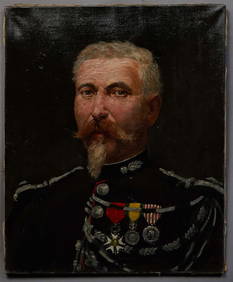
French School, "Portrait of a French Second Empire Officer," 19th c., oil on canvas, unsigned,Crescent City Auction Gallery4.3(231)See Sold PriceMar 01, 2024
Map: A 19thC engraved and hand coloured map of South America. Published by the Society for theClaydon Auctioneers Ltd4.3(125)See Sold PriceFeb 26, 2024
Map: A 19thC engraved and hand coloured map of St. Petersburg / Sanktpeterburga by W. B. Clarke.Claydon Auctioneers Ltd4.3(125)See Sold PriceFeb 26, 2024
Map: A 19thC engraved map titled Gloucestershire from the Best Authorities, after John Cary. Approx.Claydon Auctioneers Ltd4.3(125)See Sold PriceFeb 26, 2024
Map: A 19thC engraved and hand coloured map of Buckingham titled A New Map of BuckinghamshireClaydon Auctioneers Ltd4.3(125)See Sold PriceFeb 26, 2024
Map: A 19thC engraved map of West Riding, titled A Map of the North Part of the West Riding ofClaydon Auctioneers Ltd4.3(125)See Sold PriceFeb 26, 2024
1816 MAP SOUTHERN PART OF RUSSIA or MUSCOVY in EUROPE copper engraving ANTIQUEJasper524.5(9.9k)See Sold PriceFeb 27, 2024
1816 MAP NORTHERN PART OF RUSSIA or MUSCOVY in EUROPE copper engraving ANTIQUEJasper524.5(9.9k)See Sold PriceFeb 27, 2024
COLONIES FRANÇAISES en AFRIQUE. Africa Sénégal Madagascar. LEVASSEUR c1850 mapJasper524.5(9.9k)See Sold PriceFeb 28, 2024
Johnson's Africa. Colonies & tribes. Liberia Nile Delta Cape Colony 1866 mapJasper524.5(9.9k)See Sold PriceFeb 28, 2024
West Africa. Sahara caravan routes. Tribes Kingdoms Empires. LIZARS 1842 mapJasper524.5(9.9k)See Sold PriceFeb 28, 2024
Afrique Ancienne. Ancient North Africa. MALTE-BRUN c1871 old antique map chartJasper524.5(9.9k)See Sold PriceFeb 28, 2024
Antique Russian Icon of Nine Selected Saints, 19th c., H.- 14 5/8 in., W.- 12 in.Crescent City Auction Gallery4.3(231)See Sold PriceMar 09, 2024
Russian Icon of the Deisis with Prophets, 19th c., H.- 13 3/4 in., W.- 11 3/4 in.Crescent City Auction Gallery4.3(231)See Sold PriceMar 09, 2024
Russian Icon of St. John Chrysostom, 19th c., H.- 12 1/4 in., W.- 10 1/2 in.Crescent City Auction Gallery4.3(231)See Sold PriceMar 09, 2024
Rare 19thc Colton Map, Argentine Republic, Chile, Uruguay, PataguayConnoisseur Auctions3.9(336)See Sold PriceMar 16, 2024