ATLAS of ANTIENT GEOGRAPHY by SAMUEL BUTLER 1843John McInnis Auctioneers,LLC4.5(505)See Sold PriceFeb 24, 2024
18TH C. ANTIQUE MAP: FRENCH & INDIAN WAR, FRAMEDThomaston Place Auction Galleries4.4(393)See Sold PriceFeb 24, 2024
Rand McNally Railroad Map Cabinet w/ 21 Railroad MapsRail & Road Auctions4.6(165)See Sold PriceMar 08, 2024
Keith Haring - Ink on New York Map, Best Buddies, Inscribed, Signed, and DatedSapphire Auction Gallery4.1(67)See Sold PriceMar 02, 2024
LATE 17TH C. FRENCH MAP OF THE NEW WORLD BY ALEXIS-HUBERT JAILLOT (1632-1712)Thomaston Place Auction Galleries4.4(393)See Sold PriceFeb 24, 2024
Central Railroad of New Jersey Map of Sandy Hook Route-ca. 1903JM Hobby Supply and Railroad Artifact Auctions4.4(127)See Sold PriceFeb 24, 2024
Lot of Six Mixed Atlas Box Cars-HO Scale-New in BoxJM Hobby Supply and Railroad Artifact Auctions4.4(127)See Sold PriceFeb 25, 2024
Rand McNally/Santa Fe Railroad Map of Iowa-1912JM Hobby Supply and Railroad Artifact Auctions4.4(127)See Sold PriceFeb 24, 2024
NICOLAES VISSCHER (NETHERLANDS, 1618-1709) MAP OF THE NEW WORLDThomaston Place Auction Galleries4.4(393)See Sold PriceFeb 24, 2024
17TH C. WORLD MAP BY NICOLAES VISSCHER (NETHERLANDS, 1618-1709)Thomaston Place Auction Galleries4.4(393)See Sold PriceFeb 24, 2024
Lot of Six Mixed Atlas Cabooses-HO Scale-New in BoxJM Hobby Supply and Railroad Artifact Auctions4.4(127)See Sold PriceFeb 25, 2024
Sold18th c. Map of Fantasy Utopia by Johann Baptist HomannsEarly 18th century map titled "Accurata Utopiae Tabula das ist der Neu entdeckten Schalck-Welt oder des so offt benanten..." showing a non-existent fantasy "utopia" by Johann Baptist Homann publishedSee Sold Price
Sold18th c. Map of Northern Germany, Johann Baptist HomannsEarly 18th century map titled "Circulus Saxoniae inferioris" showing northern Germany including the cities of Berlin and Hamburg by Johann Baptist Homann published circa 1740. Framed map measures 19"See Sold Price
SoldJ.B. Homann, 18th c. map of IrelandJ.B. Homann, 18th c. map of Ireland, Johann Baptist Homann (German,1664-1724), "Hiberniae Regnum tam in Praecipuas Ultoniae, Connaciae, Laceniae et Momoniae quam in Minores", c. 1720, 24"h x 20.5"w (sSee Sold Price
SoldJ.B. Homann, 18th c. map of SaxonyJ.B. Homann, 18th c. map of Saxony, Johann Baptist Homann (German,1664-1724), "Circulus Saxoniae inferioris", c. 1740, including Bremen, Berlin, and Lübeck, 20.75"h x 24.5"w (sheet), unframed ProveSee Sold Price
Sold18TH C MAP, NORTH AMERICA, UNITED STATES & MEXICOJohann Baptist Homann (German, 1664-1724). "Regni Mexicani seu Novae Hispaniae" - circa 1725, engraving with hand coloring. Approx. 20.75" x 24" (sheet) Item from the Estate of Forest "Tag" Hunter, AtSee Sold Price
Sold18TH C MAP OF DENMARK, IN SEE THROUGH FRAME, NICE18TH C MAP OF DENMARK, IN SEE THROUGH FRAME, NICE OVERALL CONDITION, WITH SOME HAND COLORING. MEASURES 19 1/4" X 22 1/4?". FROM LOCAL ESTATE. JOHANN BAPTIST HOMANN (EDITOR), JOHANN HUBNER (CARTOGRAPHYSee Sold Price
SoldTWO 18TH CENTURY MAPS - SALZBURG, ISLE OF SKYEIncludes Johann Baptist Homann's undated 'Salisburgensis,' 19 x 22.5 inch sight size, 25 x 28.5 inch frame. Hand tinted, some tearing at edges, and stain to middle left edge. Homann was perhaps the moSee Sold Price
SoldMap: An 18thC hand coloured engraved map of England andMap: An 18thC hand coloured engraved map of England and Wales by Johann Baptist Homann titled Magnae Britanniae Pars Meridionalis in qua Regnum Angliae tam in Septem Antiqua Anglo-Saxonum Regna in a dSee Sold Price
Sold18th Century Map of the Eastern UnitedStates [Virginia Marylandia et Carolina, in America Septentrionali, Brittanorum industria excultae?], by Johann Baptist Homann, originally published in Homann's Atlas Novus, Nuremberg, Germany, 1714,See Sold Price
18th century map, eastern UnitedStates, ["Virginia Marylandia et Carolina, in America Septentrionali, Brittanorum industria exclutae…"] by Johann Baptist Homann, originally published in Homann's [Atlas Novus,] Nuremberg, Germany,See Sold Price
Sold18th Century Map of the Eastern UnitedStates [Virginia Marylandia et Carolina, in America Septentrionali, Brittanorum industria exclulae…,] by Johann Baptist Homann, originally published in Homann's [Atlas Novus,] Nuremberg, Germany, 17See Sold Price
1741 antique MAP of HOLY ROMAN GERMANIC EMPIRE IMPERII ROMANO-GERMANICI 18th c.IMPERII ROMANO-GERMANICI HOLY ROMAN (GERMANIC) EMPIRE by Homann, Johann Baptist, 1663-1724 Nuremberg, 1741 Size 20.5 by 24" Good condition. Some wear, faded dampstains, small repairs at the margins ThSee Sold Price
1741 antique MAP OF FRANCE REGNI GALLIEAE SEU FRANCIAE et Navarrae Tabula 18th CREGNI GALLIEAE SEU FRANCIAE et Navarrae Tabula Geographicea by Homann, Johann Baptist, 1663-1724 Nuremberg, 1741 size 20.5 by 24.5" Wear , damaged lower margin, as visible on the photos = Reserve: $10See Sold Price
1741 antique MAP of HOLY ROMAN GERMANIC EMPIRE IMPERII ROMANO-GERMANICI 18th c.IMPERII ROMANO-GERMANICI HOLY ROMAN (GERMANIC) EMPIRE by Homann, Johann Baptist, 1663-1724 Nuremberg, 1741 Size 20.5 by 24" Good condition. Some wear, faded dampstains, small repairs at the margins -See Sold Price
1741 antique MAP OF FRANCE REGNI GALLIEAE SEU FRANCIAE et Navarrae Tabula 18th CREGNI GALLIEAE SEU FRANCIAE et Navarrae Tabula Geographicea by Homann, Johann Baptist, 1663-1724 Nuremberg, 1741 size 20.5 by 24.5" Wear , damaged lower margin, as visible on the photos Reserve: $105.See Sold Price
1741 antique MAP of HOLY ROMAN GERMANIC EMPIRE IMPERII ROMANO-GERMANICI 18th c.IMPERII ROMANO-GERMANICI HOLY ROMAN (GERMANIC) EMPIRE by Homann, Johann Baptist, 1663-1724 Nuremberg, 1741 Size 20.5 by 24" Good condition. Some wear, faded dampstains, small repairs at the margins ThSee Sold Price
1741 antique MAP OF FRANCE REGNI GALLIEAE SEU FRANCIAE et Navarrae Tabula 18th CREGNI GALLIEAE SEU FRANCIAE et Navarrae Tabula Geographicea by Homann, Johann Baptist, 1663-1724 Nuremberg, 1741 size 20.5 by 24.5" Wear , damaged lower margin, as visible on the photos = Reserve: $10See Sold Price
Antique Map Print - Johann Baptist Homann - Map of Belgium and LuxembourgA beautifully detailed c. 1747 J. B. Homann's map of Belgium and Luxembourg. Depicts Belgium and Luxembourg as well as parts of Holland, France and Germany. The map notes fortified cities, villages, rSee Sold Price
SoldJohann Baptist Homann Map of the AmericasJohann Baptist Homann Map of the Americas "Totius Americae Septentionalis et Meridionalis," Nuremburg, Germany, mid-18th century by his Homann's heirs, hand-colored copperplate engraving with manuscriSee Sold Price
SoldHomann's map of DanubeFluviorum in Europa principis Danubii cum adiacentibus Regnis. Johann Baptist Homann (1664-1724). Hand-colored engraved map. Nuremberg: Homann, c.1740. 21 x 23 1/4 inches sheet. Handsome map illustratSee Sold Price
1720 antique MAP of LOWER SAXONY GERMANY 18th CENT. Circulus Saxoniae inferiorisCirculus Saxoniae inferioris by Homann, Johann Baptist, 1663-1724 Nuremberg, c. 1720 Size 20.5 by 23.5" Good condition, some wear - The Homann family was the most important map publisher in Germany inSee Sold Price
Homann, Johann Baptist. Regnum BorussiaeHomann, Johann Baptist Regnum Borussiae C. 1745 Copperplate engraving; area coloured Printed area: 57.5 x 48.5 cm; 22.6 x 19 in Almost identical map to the 1715 edition of Homann's map of Prussia. FreSee Sold Price
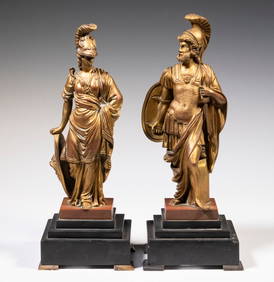
LATE 18TH C FRENCH PAIR OF GILT BRONZE STATUES OF THE GREEK GOD AND GODDESS OF WARThomaston Place Auction Galleries4.4(393)See Sold PriceFeb 24, 2024
EARLY 18TH C. DUTCH CHART OF PACIFIC OCEAN BY FREDERIK DE WIT (1629-1706) WITH CALIFORNIA AS ANThomaston Place Auction Galleries4.4(393)See Sold PriceFeb 24, 2024
EARLY 18TH C. MAP OF ITALY, FRAMEDThomaston Place Auction Galleries4.4(393)See Sold PriceFeb 24, 2024
18TH C. ANTIQUE MAP: FRENCH & INDIAN WAR, FRAMEDThomaston Place Auction Galleries4.4(393)See Sold PriceFeb 24, 2024
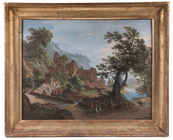
AN 18TH C. ITALIAN CAPRICCIO PAINTINGThomaston Place Auction Galleries4.4(393)See Sold PriceFeb 24, 2024
18TH C. FLORENTINE MINIATURE OF THE MADONNAThomaston Place Auction Galleries4.4(393)See Sold PriceFeb 24, 2024
American Federal Period Maple Chest, Late 18th C.Auctions at Showplace4.6(740)See Sold PriceMar 03, 2024
PAIR (18th c) OF FLINTLOCK DUELING PISTOLSJohn McInnis Auctioneers,LLC4.5(505)See Sold PriceFeb 24, 2024
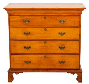
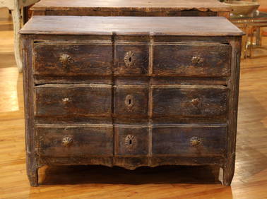
(18th c) ENGLISH BOOK-MATCHED CHEST OF DRAWERSJohn McInnis Auctioneers,LLC4.5(505)See Sold PriceFeb 24, 2024
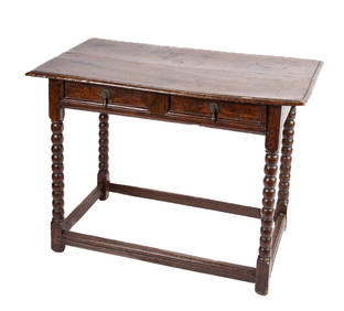
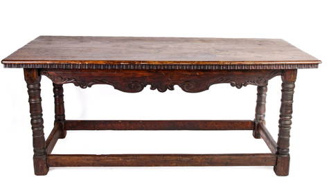
(18th c) CONTINENTAL OAK REFRACTORY TABLEJohn McInnis Auctioneers,LLC4.5(505)See Sold PriceFeb 24, 2024
(18th c) SAMPLER by SARAH BROWN born 1780.John McInnis Auctioneers,LLC4.5(505)See Sold PriceFeb 25, 2024
(18th c) NEW HAMPSHIRE CHERRY BIRD CAGE TEA TABLEJohn McInnis Auctioneers,LLC4.5(505)See Sold PriceFeb 25, 2024
Johann Homann Hand-Colored Map Engraving, c. 1730Auctions at Showplace4.6(740)See Sold PriceMar 17, 2024
18th C. QUEEN ANNE CHINOISERIE DRESSING MIRRORLewis & Maese Antiques & Auction4.4(527)See Sold PriceFeb 25, 2024
Period 18Th C. Queen Anne Bonnet Top Tiger Maple HighboyRalph Fontaine Heritage Auctions Inc.4.7(236)See Sold PriceFeb 25, 2024
Two (2) Antique 18th C. Copper Engraved Framed Maps - America & EuropeMagnusson Art Group4.5(53)See Sold PriceMar 14, 2024