SoldJ.B. Homann, 18th c. map of SaxonyJ.B. Homann, 18th c. map of Saxony, Johann Baptist Homann (German,1664-1724), "Circulus Saxoniae inferioris", c. 1740, including Bremen, Berlin, and Lübeck, 20.75"h x 24.5"w (sheet), unframed ProveSee Sold Price
SoldJ.B. Homann, 18th c. map of IrelandJ.B. Homann, 18th c. map of Ireland, Johann Baptist Homann (German,1664-1724), "Hiberniae Regnum tam in Praecipuas Ultoniae, Connaciae, Laceniae et Momoniae quam in Minores", c. 1720, 24"h x 20.5"w (sSee Sold Price
SoldPomerania Central Europe Antique MapDucatus Pomeraniae. Hand-colored engraved map. J.B. Homann, Nuremberg, 18th C.. 21" x 24".See Sold Price
SoldVisscher & Homann Antique Maps (4)Flandriae Comitatus Pars Batava, N. Visscher, Amsterdam, Late 17th C. Plus 3 maps by J.B. Homann, Nuremberg, 18th C.. 21" x 24".See Sold Price
SoldBurgandy France Antique MapComitatus Burgundiae. Hand-colored engraved map. French wine region. J.B. Homann, Nuremberg, 18th C. 24 3/4" x 21".See Sold Price
(4) ANTIQUE MAPS, MORAVIA, SAXONY, OTHERS, 18TH C.(lot of 4) Antique maps, including: (1) "Marchionatus Moravia Circulus Hradistiensi...," Homann, c.1737, approx 21.5"h, 25.75"w; (1) "Principatus Gotha, Coburg et Altenburg," c.1788, Johann Homann (GeSee Sold Price
SoldSet of 4 historical maps of Saxony,Set of 4 historical maps of Saxony, 17th/18th c., ''Alta Sachsa'' by Antonio Zatta, border colored map of the 18th c., ''Circuli Super Saxoniae'', border col. Map by Homann in Nuremberg c. 1720, ''HauSee Sold Price
1720 antique MAP of LOWER SAXONY GERMANY 18th CENT. Circulus Saxoniae inferiorisCirculus Saxoniae inferioris by Homann, Johann Baptist, 1663-1724 Nuremberg, c. 1720 Size 20.5 by 23.5" Good condition, some wear - The Homann family was the most important map publisher in Germany inSee Sold Price
1720 antique MAP of LOWER SAXONY GERMANY 18th CENT. Circulus Saxoniae inferiorisCirculus Saxoniae inferioris by Homann, Johann Baptist, 1663-1724 Nuremberg, c. 1720 Size 20.5 by 23.5" Good condition, some wear The Homann family was the most important map publisher in Germany in tSee Sold Price
1720 antique MAP of LOWER SAXONY GERMANY 18th CENT. Circulus Saxoniae inferiorisCirculus Saxoniae inferioris by Homann, Johann Baptist, 1663-1724 Nuremberg, c. 1720 Size 20.5 by 23.5" Good condition, some wear The Homann family was the most important map publisher in Germany in tSee Sold Price
1720 antique MAP of LOWER SAXONY GERMANY 18th CENT. Circulus Saxoniae inferiorisCirculus Saxoniae inferioris by Homann, Johann Baptist, 1663-1724 Nuremberg, c. 1720 Size 20.5 by 23.5" Good condition, some wear The Homann family was the most important map publisher in Germany in tSee Sold Price
SoldHomann Heirs (German, 18th c.) World MapHomann Heirs (German, 18th c.) , "Planiglobii Terrestris Mappa Universalis...", double page, double hemisphere, world map, hand-colored copper engraving, 1746, with four hemispheric projections, two cSee Sold Price
SoldJ.B Homann c.1737 Map of Hiberniae RegnumJ.B Homann c.1737 unframed coloured engraving, Map of Hiberniae Regnum, 22 x 18.5 ins.See Sold Price
SoldJ.B Homann c.1737 Map of Hiberniae Regnum, 22 x 1J.B Homann c.1737 unframed coloured engraving, Map of Hiberniae Regnum, 22 x 18.5 ins.See Sold Price
SoldJ.B Homann c.1737 Map of Hiberniae Regnum, 22 x 1J.B Homann c.1737 unframed coloured engraving, Map of Hiberniae Regnum, 22 x 18.5 ins.See Sold Price
Sold18TH C. HOMANN HAND COLORED MAP OF CASPIAN SEAThe framed map also depicting parts of Russia. 19.5" X 23" Provenance: A New Haven, CT estateSee Sold Price
NOVA ANGLIA, MAP, JOH. BAPTISTA HOMANN 18TH.C"NOVA ANGLIA, MAP, JOH. BAPTISTA HOMANN, 18TH.C. 19"" X 22"":Pars Canadae seu, Novae Franciae. NOVA ANGLIA, [New England. ] Septentrionali Americae implantata. Fold down center. Double page engraving.See Sold Price
Sold18thC Geographical/Astronomical Map, Homann18th Century geographical and astronomical hand-colored engraved map with eight observation tables, 19" x 22 1/2" sight size, framed 25 1/2" x 29", signed Johannus Homann, cartographer. Good conditon.See Sold Price
SoldPhaenomena Motuum Irregularium, celestial mapPhaenomena Motuum Irregularium, celestial map, 18th c., Doppelmayr/Homann, each sheet: 19"h x 22.5"w (sight), 43.5"h x 26.75"w (framed ensuite) Provenance: Property from a New York Corporate CollectioSee Sold Price
SoldFRAMED RARE 18TH C. MAP OF CORFU BY HOMANNSPlan de la Place de Corfu avec ses Environs Assiegee Par les Infideles, tranchee ouverte le 25me Juillet jusqu'au 22 me d'Aout, Iour de la Fuite des Ottomans". Homann, J. B. Circa 1740. Hand colored cSee Sold Price
Sold18TH C MAP, NORTH AMERICA, UNITED STATES & MEXICOJohann Baptist Homann (German, 1664-1724). "Regni Mexicani seu Novae Hispaniae" - circa 1725, engraving with hand coloring. Approx. 20.75" x 24" (sheet) Item from the Estate of Forest "Tag" Hunter, AtSee Sold Price
Sold18th c. Map of Fantasy Utopia by Johann Baptist HomannsEarly 18th century map titled "Accurata Utopiae Tabula das ist der Neu entdeckten Schalck-Welt oder des so offt benanten..." showing a non-existent fantasy "utopia" by Johann Baptist Homann publishedSee Sold Price
SoldRARE 18TH C. MAP OF THE AMERICASHomann Heirs / Johann Matthaus Haas: "Americae Mappa generalis Secundum legimitas projectionis Stereiographiae regulas . . . MDCCXXXXVI". Nuremberg, 1746. Copperplate engraving on laid paper with handSee Sold Price
EARLY 18TH C. DUTCH CHART OF PACIFIC OCEAN BY FREDERIK DE WIT (1629-1706) WITH CALIFORNIA AS ANThomaston Place Auction Galleries4.4(386)See Sold PriceFeb 24, 2024
EARLY 18TH C. MAP OF ITALY, FRAMEDThomaston Place Auction Galleries4.4(386)See Sold PriceFeb 24, 2024
18TH C. ANTIQUE MAP: FRENCH & INDIAN WAR, FRAMEDThomaston Place Auction Galleries4.4(386)See Sold PriceFeb 24, 2024
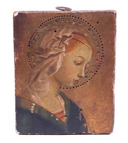
18TH C. FLORENTINE MINIATURE OF THE MADONNAThomaston Place Auction Galleries4.4(386)See Sold PriceFeb 24, 2024
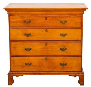
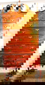
American Federal Period Maple Chest, Late 18th C.Auctions at Showplace4.5(726)See Sold PriceMar 03, 2024
PAIR (18th c) OF FLINTLOCK DUELING PISTOLSJohn McInnis Auctioneers,LLC4.6(502)See Sold PriceFeb 24, 2024
(18th c) ENGLISH BOOK-MATCHED CHEST OF DRAWERSJohn McInnis Auctioneers,LLC4.6(502)See Sold PriceFeb 24, 2024
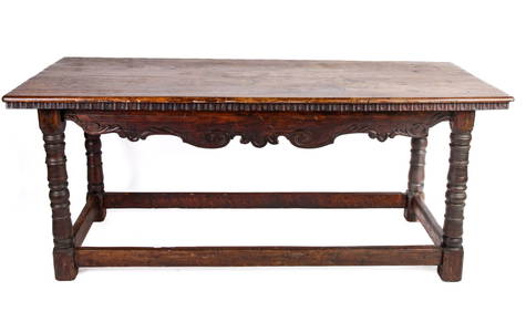
(18th c) CONTINENTAL OAK REFRACTORY TABLEJohn McInnis Auctioneers,LLC4.6(502)See Sold PriceFeb 24, 2024
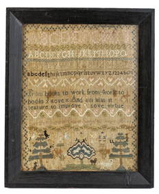
(18th c) SAMPLER by SARAH BROWN born 1780.John McInnis Auctioneers,LLC4.6(502)See Sold PriceFeb 25, 2024
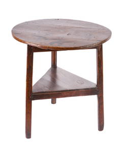
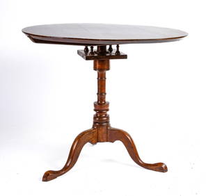
(18th c) NEW HAMPSHIRE CHERRY BIRD CAGE TEA TABLEJohn McInnis Auctioneers,LLC4.6(502)See Sold PriceFeb 25, 2024
Johann Homann Hand-Colored Map Engraving, c. 1730Auctions at Showplace4.5(726)See Sold PriceMar 17, 2024
Period 18Th C. Queen Anne Bonnet Top Tiger Maple HighboyRalph Fontaine Heritage Auctions Inc.4.7(235)See Sold PriceFeb 25, 2024
Two (2) Antique 18th C. Copper Engraved Framed Maps - America & EuropeMagnusson Art Group4.5(46)See Sold PriceMar 14, 2024
1758 MAP PARTIE DE LA MER GLACIALE contenants La Nouvelle Zemble RUSSIA antiqueJasper524.5(9.8k)See Sold PriceFeb 27, 2024
ANTIQUE ROMAN ARMORIAL VELLUM BINDING, 1744, ILLUSTRATED WITH AN ANTIQUE MAP BY FLORUSNY Elizabeth 4.3(84)See Sold PriceMar 03, 2024
THE WHOLE CHRONICLE OF POLYBIUS ANCIENT IN ENGLISH, 1756NY Elizabeth 4.3(84)See Sold PriceMar 03, 2024