Sold1855 MAP OF IOWA BY J.H. COLTONPre-Civil War map of the state, professionally matted, 13 x 15.5 inch sight size.See Sold Price
Sold1855 Map of Iowa.1855 Map of Iowa, 16" x 18-1/4" sheet size. Published by J. H. Colton & Co. , NYC. Size 18 -1/2" x 16 -1/4".See Sold Price
1855 Colton Map of Iowa -- IowaTitle/Content of Map: 1855 Colton Map of Iowa -- Iowa Date: 1855, New York Cartographer: J Colton Size: 11.8 X 15.1 in. This is a very nice map of Iowa. Much of the western portion is very sparsely seSee Sold Price
1855 Township Map of IowaHeading: (Iowa) Author: Title: A Township Map of the State of Iowa Place Published: Fairfield, Iowa and Philadelphia Publisher:Henn, Williams & Co and R. L. Barnes Date Published: 1855See Sold Price
Colton Map of Iowa, 1855Colton, J. H. & Co. Colton's Township Map of the State of Iowa. Lithographed Map. 1855. 24" x 29" sheet. Compiled from the United States Surveys, & other authentic sources. Folding map of IA with counSee Sold Price
SoldMendenhall MAP OF IOWA 1855 Folding Pocket Period HandDetails: IOWA - MENDENHALL, E. Map of Iowa Exhibiting the Townships, Cities, Villages, Post Offices, Railroads, Common Roads and other Improvements. Cincinnati: Mendenhall, 1855. Folding pocket map,See Sold Price
SoldGreat early map of Iowa by Cowperthwait, 1855Early and desirable map of Iowa, hand colored by counties, showing railroads, stage lines, canals, forts, towns, roads, rivers, lakes and more. Possibly one of the very best early maps of this state.See Sold Price
Great Colton map of IowaAn excellent 1855 first edition example of Colton's map of Iowa. Like most of Colton's state maps, this map was derived from an earlier wall map of North America produced by Colton and D. Griffing JohSee Sold Price
Great Colton map of IowaAn excellent 1855 first edition example of Colton's map of Iowa. Like most of Colton's state maps, this map was derived from an earlier wall map of North America produced by Colton and D. Griffing JohSee Sold Price
Sold1855 Smith Map of the MidWest -- Guide through Ohio,Title/Content of Map: 1855 Smith Map of the MidWest -- Guide through Ohio, Michigan, Indiana, Illinois, Missouri, Wisconsin & Iowa Showing the Township Lines of the United States Surveys Date Printed:See Sold Price
Antique 1855 Smith Map of the MidWestTitle/Content of Map: 1855 Smith Map of the MidWest -- Guide through Ohio, Michigan, Indiana, Illinois, Missouri, Wisconsin & Iowa Showing the Township Lines of the United States Surveys Date Printed:See Sold Price
SoldColton's Iowa Map [Midwestern States]Colton's Illinois Map. J. H. Colton Cartographer. Published by J. H. Colton, New York. Stamped 'Entered according to Act of Congress in the Year 1855 by J. H. Colton and Co. in in the Clerks Office ofSee Sold Price
SoldTownship Map of IowaHeading: (Iowa) Author: Title: A Township Map of the State of Iowa Place Published: Philadelphia Publisher: Date Published: 1855 Description: Colored folding map, 21 x 34 iSee Sold Price
Township Map of IowaHeading: (Iowa) Author: Title: A Township Map of the State of Iowa Place Published: Philadelphia Publisher: Date Published: 1855 Description: Colored folding map, 21 x 34 iSee Sold Price
Smith: Antique Map of the MidWest, 1855Title/Content of Map: 1855 Smith Map of the MidWest -- Guide through Ohio, Michigan, Indiana, Illinois, Missouri, Wisconsin & Iowa Showing the Township Lines of the United States Surveys Date Printed:See Sold Price
Smith: Antique Map of the MidWest, 1855Title/Content of Map: 1855 Smith Map of the MidWest -- Guide through Ohio, Michigan, Indiana, Illinois, Missouri, Wisconsin & Iowa Showing the Township Lines of the United States Surveys Date Printed:See Sold Price
SoldColton/Johnson State Maps [Various State Maps]Four Colton Maps - Illinois, Indiana, Iowa and New Hampshire. J. H. Colton Cartographer. Published by J. H. Colton, New York. Stamped 'Entered according to Act of Congress in the Year 1855 by J. H. CoSee Sold Price
SoldColton's western tourtist. 1855SMITH, J. Calvin Guide through Ohio, Michigan, Indiana, Illinois, Missouri, Wisconsin & Iowa.New York: J. H. Colton, 1855. Hand-colored engraved folding pocket map (20 ½ x 26 inches, 520x660See Sold Price
United States.Title: United States. Publication Date: 1855 ca. Cartographer: ANONYMOUS Publisher: Size: 12Height - 9.8Width Unidentified English school atlas map of the country west to Missouri, Iowa, Arkansas andSee Sold Price
Sold1855 MAP OF ANTARCTICA BY G.W. AND C.B. COLTON1855 date entered by J.H. Colton & Co., matted, 16 x 13 inch sight size. Not examined outside of wrappings, appears excellent.See Sold Price
Sold1855 MAP OF THE ARCTIC BY G.W. AND C.B. COLTON1855 date entered by J.H. Colton & Co., matted, 16 x 13 inch sight size. Not examined outside of wrappings, appears excellent.See Sold Price
Sold1855 MAP THE CITY OF CHARLESTON, SOUTH CAROLINAMap of the City of Charleston, South Carolina , published by JH Colton & Co, New York in 1855. Good condition. Paper size 11 1/2"x7". Professionally framed and matted. In frame 11 1/2"x15 1/2"x1". WeiSee Sold Price
Sold1855 Map of The East Coast Of North America 76x411855 Map of The East Coast Of North America 76x41See Sold Price
SoldColton's 1855 Map of VermontColton's 1855 Map of Vermont with hand colored counties 18 x 15"See Sold Price
Michigan Southern and Northern Indiana RR 14th Annual Report-February 28, 1869JM Hobby Supply and Railroad Artifact Auctions4.4(126)See Sold PriceFeb 24, 2024
Rand McNally/Santa Fe Railroad Map of Iowa-1912JM Hobby Supply and Railroad Artifact Auctions4.4(126)See Sold PriceFeb 24, 2024
Rock Island RR Iowa and Minnesota Lakes Country Brochure-1926JM Hobby Supply and Railroad Artifact Auctions4.4(126)See Sold PriceFeb 24, 2024
Great Western RY November 1, 1880 Public TimetableJM Hobby Supply and Railroad Artifact Auctions4.4(126)See Sold PriceFeb 24, 2024
19thc Colton Map, Comparitive Size of Lakes & IslandsConnoisseur Auctions4(333)See Sold PriceFeb 24, 2024
Archaeological Books - Bowman - Remains of Antiquity Relating to the County of YorkTimeLine Auctions Ltd.4.5(183)See Sold PriceMar 06, 2024
1855 Guide for the Pennsylvania Railroad with an Extensive Map from the Pennsylvania RailroadRail & Road Auctions4.6(165)See Sold PriceMar 07, 2024
1855 Map of New York & Erie Railroad and 1917 Trespassing On Railway Property Is A MisdemeanorRail & Road Auctions4.6(165)See Sold PriceMar 07, 2024
William Simpson's Sketches at the Seat of War - Two Volumes with 81 Hand-colored LithographsTrillium Antique Prints & Rare Books4.5(30)See Sold PriceFeb 24, 2024
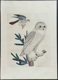
Wilson - Snow Owl (Snowy Owl) & Sparrow Hawk. 32Trillium Antique Prints & Rare Books4.5(30)See Sold PriceFeb 24, 2024
Wilson - Ivory-billed Woodpecker, Red-headed & Pileated Woodpeckers. 29Trillium Antique Prints & Rare Books4.5(30)See Sold PriceFeb 24, 2024
Wilson - Carolina Parrot & Flycatchers. 26Trillium Antique Prints & Rare Books4.5(30)See Sold PriceFeb 24, 2024
1855 NOTES ON CENTRAL AMERICA by E. G. Squier antique w/ MAPSJasper524.5(9.8k)See Sold PriceFeb 27, 2024
Tour of the Dutch East Indies, with exceptional platesPBA Galleries4.7(381)See Sold PriceMar 07, 2024
Africa inc. discoveries of Livingstone Barth Vogel Chadda Exp. SWANSTON 1860 mapJasper524.5(9.8k)See Sold PriceFeb 28, 2024
Rare 19thc Colton Map, Argentine Republic, Chile, Uruguay, PataguayConnoisseur Auctions4(333)See Sold PriceMar 16, 2024
Francis McNally - Antique Map of Illinois, Missouri & IowaProverde Auctions4.3(3)See Sold PriceFeb 28, 2024
1910 USGS Topographic Map of Iowa-IllinoisRapid Estate Liquidators and Auction Gallery4.5(1.1k)See Sold PriceFeb 29, 2024
Reprint From The Original Coltons Map 1855 No.30 Copyright 1967Rapid Estate Liquidators and Auction Gallery4.5(1.1k)See Sold PriceFeb 29, 2024


![Colton's Iowa Map [Midwestern States] (1 of 3)](https://p1.liveauctioneers.com/5755/154409/77936937_1_x.jpg?height=282&quality=70&version=1573094011)


![Colton/Johnson State Maps [Various State Maps] (1 of 14)](https://p1.liveauctioneers.com/5755/157962/79722067_1_x.jpg?height=282&quality=70&version=1576875253)