MATTHEWS c1856 Map Of Upper Canada Ontario Indian Land Agency Divisions Scarce!Luis Porretta Fine Arts4.3(10)See Sold PriceMar 02, 2024
DEVINE c1856 Dr Salters Map Of Lake Huron Ontario Indian Lands etc. No. 7 ScarceLuis Porretta Fine Arts4.3(10)See Sold PriceMar 02, 2024
DUNLEVIE c1856 Map Counties Of Gaspe & Bonaventure Quebec Canada SCARCE! #1Luis Porretta Fine Arts4.3(10)See Sold PriceMar 02, 2024
DUNLEVIE c1856 Map Counties Of Gaspe & Bonaventure Quebec Canada SCARCE! #2Luis Porretta Fine Arts4.3(10)See Sold PriceMar 02, 2024
Map UNITED COUNTIES LEEDS & GRENVILLE by Walling 1861 Rare Canada Map 5ft x 5ftLuis Porretta Fine Arts4.3(10)See Sold PriceMar 02, 2024
Ambroise TARDIEU c1822 Map Venice Napoleon Italian Campaign 17" x 11"Luis Porretta Fine Arts4.3(10)See Sold PriceMar 02, 2024
Smith: Antique Map of the MidWest, 1855Title/Content of Map: 1855 Smith Map of the MidWest -- Guide through Ohio, Michigan, Indiana, Illinois, Missouri, Wisconsin & Iowa Showing the Township Lines of the United States Surveys Date Printed:See Sold Price
Smith: Antique Map of the MidWest, 1855Title/Content of Map: 1855 Smith Map of the MidWest -- Guide through Ohio, Michigan, Indiana, Illinois, Missouri, Wisconsin & Iowa Showing the Township Lines of the United States Surveys Date Printed:See Sold Price
Antique 1855 Smith Map of the MidWestTitle/Content of Map: 1855 Smith Map of the MidWest -- Guide through Ohio, Michigan, Indiana, Illinois, Missouri, Wisconsin & Iowa Showing the Township Lines of the United States Surveys Date Printed:See Sold Price
SoldSmith: Antique Railroad Map of the United States, 1855Map: Map of the United States of America, Showing the Rail Roads. Large, Colorful Railroad Map of U.S. 1855 Publication Date: 1855 Authors: HARPER & BROTHERS, SMITH, J. CALVIN / D. MCLELLAN Publisher:See Sold Price
Smith: Antique Map of the Roman Empire, 1853Title/Content of Map: Map of the Roman Empire Date Printed: 1855 Cartographer: SMITH, ROSWELL C. Publisher: DANIEL BURGESS & CO. 1855 NEW YORK Size: Double Quarto – 11.25 H x 18.75 W Inches From SmiSee Sold Price
Sold1855 Smith Map of the MidWest -- Guide through Ohio,Title/Content of Map: 1855 Smith Map of the MidWest -- Guide through Ohio, Michigan, Indiana, Illinois, Missouri, Wisconsin & Iowa Showing the Township Lines of the United States Surveys Date Printed:See Sold Price
Mclellan: Antique Map of Asia, 1855Title/Content of Map: Asia Cartographer: MCLELLAN, D. Size: 18.6X22.75 "To illustrate Harper's Gazetteer." From Harper's gazetteer of the world. By J. Calvin Smith. Cartographer unmentioned in Tooley'See Sold Price
Sold2 Large Antique Maps2 Large Antique Maps, one wall sized map is a beautiful map by Smith's of Hartford County Connecticut, fram actual surveys by E. M. Woodford, C.S. West Avon, 1855, with beautiful depictions down the sSee Sold Price
SoldSmith: Antique Map of the World, 1835Map: 1835 Smith World Map -- A Chart Exhibiting the Actual and Comparative Size of each Country, Nation, or Kingdom; its Population as a Whole and to a Square Mile. Also the Different States of SocietSee Sold Price
SoldSmith: Antique Map of South America, 1894Title/Content of Map: 1894 Smith Map of South America [verso] Columbia, Venezuala, Peru, Equador, Argentina -- Map of South America Showing its Political Divisions [verso] Map of U.S. of Columbia VeneSee Sold Price
Smith: Antique Map of the World Map, 1835Title/Content of Map: 1835 Smith World Map -- A Chart Exhibiting the Actual and Comparative Size of each Country, Nation, or Kingdom; its Population as a Whole and to a Square Mile. Also the DifferentSee Sold Price
Smith: Antique Map of South America, 1894Title/Content of Map: 1894 Smith Map of South America [verso] Columbia, Venezuala, Peru, Equador, Argentina -- Map of South America Showing its Political Divisions [verso] Map of U.S. of Columbia VeneSee Sold Price
Smith: Antique Map of Cambridge UK, 1808Title/Content of Map: 1808 Smith Map of Cambridge UK -- A New Map of the County of Cambridge Divided into Hundreds Date Printed: 1808, London Cartographer: C Smith Size: 19.5 x 17.4 in. Condition: VerSee Sold Price
SoldSmith: Antique Map of Asia, 1894Map: 1894 Smith Map of Asia [verso] South Central Europe -- Map of Asia Showing its Geopolitical Divisions, and also the Various Routes of Travel between London & India, China & Japan &c. [verso] AustSee Sold Price
Smith: Antique Map of Berkshire UK, 1808Title/Content of Map: 1808 Smith Map of Berkshire UK -- A New Map of the County of Berks Divided into Hundreds Date Printed: 1808, London Cartographer: C Smith Size: 17.4 x 19.5 in. This is a very attSee Sold Price
Smith: Antique Map of China, 1906Title/Content of Map: 1906 Smith Map of China -- Chinese Empire Date Printed: 1904, New York Cartographer: B Smith Size: 10.4 x 15 in. This is a very detailed map of China, with the color coded dependSee Sold Price
Smith: Antique Map of South America, 1894Title/Content of Map: 1894 Smith Map of South America [verso] Columbia, Venezuala, Peru, Equador, Argentina -- Map of South America Showing its Political Divisions [verso] Map of U.S. of Columbia VeneSee Sold Price
Smith: Antique Map of North America | Africa, 1873Title/Content of Map: North America | Africa Date Printed: 1873 Cartographer: SMITH, CHARLES M. Size: 11.75X9.5 Lightly browned.Blank outline maps on polar projection filled in and signed by student CSee Sold Price
Smith: Antique Map of Virginia Maryland Delaware, 1894Title/Content of Map: 1894 Smith Map of the Virginias, Maryland and Delaware -- County Map of the States of Delaware, Maryland, Virginia and West Virginia Date Printed: 1894 Cartographer: AL Smith (PuSee Sold Price
Smith: Antique Map of Cambridge UK, 1808Title/Content of Map: 1808 Smith Map of Cambridge UK -- A New Map of the County of Cambridge Divided into Hundreds Date Printed: 1808, London Cartographer: C Smith Size: 19.5 x 17.4 in. This is a verySee Sold Price
Smith: Antique Map of Berkshire UK, 1808Title/Content of Map: 1808 Smith Map of Berkshire UK -- A New Map of the County of Berks Divided into Hundreds Date Printed: 1808, London Cartographer: C Smith Size: 17.4 x 19.5 in. This is a very attSee Sold Price
Smith: Antique Map of Cambridge UK, 1808Title/Content of Map: 1808 Smith Map of Cambridge UK -- A New Map of the County of Cambridge Divided into Hundreds Date Printed: 1808, London Cartographer: C Smith Size: 19.5 x 17.4 in. This is a verySee Sold Price
Smith: Antique Map of Berkshire UK, 1808Map: 1808 Smith Map of Berkshire UK -- A New Map of the County of Berks Divided into Hundreds Date Printed: 1808, London Cartographer: C Smith Size: 17.4 x 19.5 in. Condition: Very Good. Sharp imagesSee Sold Price
1835 Smith Antique Map of the WorldTitle/Content of Map: 1835 Smith World Map -- A Chart Exhibiting the Actual and Comparative Size of each Country, Nation, or Kingdom; its Population as a Whole and to a Square Mile. Also the DifferentSee Sold Price
17TH C. ANTIQUE MAP SIEGE OF LA ROCHELLE, FRANCE, FRAMEDThomaston Place Auction Galleries4.4(386)See Sold PriceFeb 24, 2024
18TH C. ANTIQUE MAP: FRENCH & INDIAN WAR, FRAMEDThomaston Place Auction Galleries4.4(386)See Sold PriceFeb 24, 2024
ORIGINAL WATERCOLOR BY DOT SMITH FRAMED MID WEST CABINAlice Callahan Auction House4.4(56)See Sold PriceMar 02, 2024
William Simpson's Sketches at the Seat of War - Two Volumes with 81 Hand-colored LithographsTrillium Antique Prints & Rare Books4.5(28)See Sold PriceFeb 24, 2024
Wilson - Wood Thrush, Red-breasted Thrush or Robin, & Nuthatches. 2Trillium Antique Prints & Rare Books4.5(28)See Sold PriceFeb 24, 2024
Wilson - Grosbeak, Warbler, Siskin, & Flycatcher. 17Trillium Antique Prints & Rare Books4.5(28)See Sold PriceFeb 24, 2024
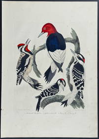
Wilson - Woodpeckers - Red-headed, Yellow-bellied, Hairy, & Downy. 9Trillium Antique Prints & Rare Books4.5(28)See Sold PriceFeb 24, 2024
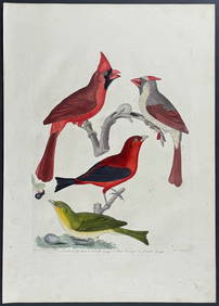
Wilson - Cardinal Grosbeak & Red Tanager. 11Trillium Antique Prints & Rare Books4.5(28)See Sold PriceFeb 24, 2024
Wilson - Mottled Owl, Lark, Creeper, & Warbler. 19Trillium Antique Prints & Rare Books4.5(28)See Sold PriceFeb 24, 2024
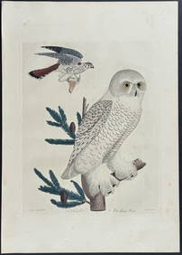
Wilson - Snow Owl (Snowy Owl) & Sparrow Hawk. 32Trillium Antique Prints & Rare Books4.5(28)See Sold PriceFeb 24, 2024
Wilson - Ivory-billed Woodpecker, Red-headed & Pileated Woodpeckers. 29Trillium Antique Prints & Rare Books4.5(28)See Sold PriceFeb 24, 2024
Wilson - Carolina Parrot & Flycatchers. 26Trillium Antique Prints & Rare Books4.5(28)See Sold PriceFeb 24, 2024
1855 NOTES ON CENTRAL AMERICA by E. G. Squier antique w/ MAPSJasper524.5(9.7k)See Sold PriceFeb 27, 2024
Coste Occidentale d’Afrique…' West Africa. Gulf of Guinea. BELLIN 1746 mapJasper524.5(9.7k)See Sold PriceFeb 28, 2024
Africa inc. discoveries of Livingstone Barth Vogel Chadda Exp. SWANSTON 1860 mapJasper524.5(9.7k)See Sold PriceFeb 28, 2024
Cooke, George 1801 Antique Map. United States of AmericaAlbion Auctions4.7(335)See Sold PriceMar 01, 2024
Jules de Liron d’Airoles (1802 - 1882) - Antique Fruit Print of Pond's Seedling PlumProverde Auctions4.3(3)See Sold PriceFeb 28, 2024
Francis McNally - Antique Map of Ohio, Indiana & KentuckyProverde Auctions4.3(3)See Sold PriceFeb 28, 2024
Antique Map of Poland, 1700 by Guillaume De Lisle, ParisAntiques Online Auctions4.6(405)See Sold PriceMar 14, 2024