Charles & Ray Eames for Herman Miller Lounge ChairAuctions at Showplace4.5(726)See Sold PriceMar 03, 2024
Eames for Herman Miller Executive Soft Pad ChairAuctions at Showplace4.5(726)See Sold PriceMar 03, 2024
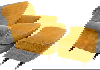
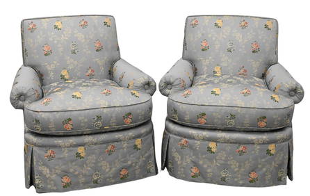
Lewis Mittman Upholstered Club Chair and OttomanNadeau's Auction Gallery4.7(401)See Sold PriceFeb 24, 2024
Chintz Tufted Upholstered Club Chair with a Matching Slipper Chair, Designed by Mario BuattaSTAIR4.6(286)See Sold PriceMar 06, 2024
Philippe Starck x Aleph "Costes" Sapele Chairs, 5Auctions at Showplace4.5(726)See Sold PriceMar 03, 2024
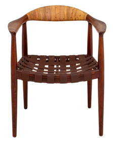
Hans Wegner for J. Hansen JH-501 Teak Arm ChairAuctions at Showplace4.5(726)See Sold PriceMar 03, 2024
Pair of Lewis Mittman Incorporated Custom Upholstered Swivel ArmchairsNadeau's Auction Gallery4.7(401)See Sold PriceFeb 24, 2024
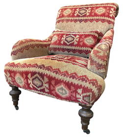
Pair of Mid Century Modern Barrel back ArmchairsBodnar's Auction Sales4.6(609)See Sold PriceMar 06, 2024
A pair of Gio Ponti for M. Singer and Sons lounge chairsJohn Moran Auctioneers, Inc.4.7(453)See Sold PriceFeb 27, 2024
SoldTownship Map of IowaHeading: (Iowa) Author: Title: A Township Map of the State of Iowa Place Published: Philadelphia Publisher: Date Published: 1855 Description: Colored folding map, 21 x 34 iSee Sold Price
1855 Township Map of IowaHeading: (Iowa) Author: Title: A Township Map of the State of Iowa Place Published: Fairfield, Iowa and Philadelphia Publisher:Henn, Williams & Co and R. L. Barnes Date Published: 1855See Sold Price
Township Map of IowaHeading: (Iowa) Author: Title: A Township Map of the State of Iowa Place Published: Philadelphia Publisher: Date Published: 1855 Description: Colored folding map, 21 x 34 iSee Sold Price
SoldIowa Township Map GEORGE C WOOLWORTH COLTON 1869Details: IOWA - COLTON, George W. (1827-1901). G. W. Colton's Township Map of the State of Iowa. New York: G.W. & C.B. Colton, 1869. Folding pocket map, full period hand-coloring, ornamental border.See Sold Price
SoldHenn Williams Barnes TOWNSHIP MAP OF THE STATE OF IOWADetails: IOWA - HENN, WILLIAMS & Co. and R. BARNES (publishers). A Township Map of the State of Iowa Compiled from the United States Surveys, official information and personal reconnaissance, showingSee Sold Price
Colton's Township Map of the State of IowaReserve Reduced! Title: Colton's Township Map of the State of Iowa Publication Date: 1855 Cartographer: COLTON, J.H. & CO. Publisher: J.H. COLTON & CO. Size (inches): 24 x 29 Scarce reprint of Burr NYSee Sold Price
Township Map of the State of Iowa, 1863Author: Colton, G. Woolworth Lithographed map, hand-colored. 45x61 cm. (17¾x24") including decorative border; folding into blindstamped cloth covers stamped in gilt, 5¾x3¾. Bright map of Iowa withSee Sold Price
Colton's Township Map of the State of IowaPublication Date: 1855 Title: Colton's Township Map of the State of Iowa Cartographer: COLTON, J.H. & CO. Publisher: J.H. COLTON & CO. Height: 24 Width: 29 "compiled from the United States Surveys, &See Sold Price
County and Township Map of the State of Iowa andTitle: County and Township Map of the State of Iowa and Missouri Publication Date: 1886 Cartographer: GAMBLE, W.H. Publisher: MITCHELL, S.A. Brief Descriptions: 74. 75. Map with counties separately coSee Sold Price
Colton's Township Map of the State of IowaTitle: Colton's Township Map of the State of Iowa Publication Date: 1855 Publisher: J.H. COLTON & CO. Size: 24 x 29 "compiled from the United States Surveys, & other authentic sources." Folding map ofSee Sold Price
Colton's Township Map of the State of IowaPublication Date: 1855 Title: Colton's Township Map of the State of Iowa Cartographer: COLTON, J.H. & CO. Publisher: J.H. COLTON & CO. Height: 24 Width: 29 "compiled from the United States Surveys, &See Sold Price
SoldJohnson's New Railroad and Township Copper Plate Map58. [MAP]. JOHNSON, A[lvin] J[ewett]. Johnson's New Railroad and Township Copper Plate Map of Wisconsin, Iowa, Minnesota & Nebraska From The Latest and Best Authorities. 1858 A. J. Johnson, Ill., BroaSee Sold Price
1876 Mitchell Map of Iowa and Missouri -- County &Title/Content of Map: 1876 Mitchell Map of Iowa and Missouri -- County & Township Map of the States of Iowa and Missouri Date: 1876 Philadelphia Cartographer: S MitchellSize: 21.2 X 14.5 in. This is aSee Sold Price
Colton Map of Iowa, 1855Colton, J. H. & Co. Colton's Township Map of the State of Iowa. Lithographed Map. 1855. 24" x 29" sheet. Compiled from the United States Surveys, & other authentic sources. Folding map of IA with counSee Sold Price
Sold* COLTON, George Woolworth. Colton's County and* COLTON, George Woolworth (1827-1901). Colton's County and Township Rail Road Map of Wisconsin, Illinois, Missouri, & Iowa. New York and Chicago: G. Woolworth Colton, Rufus Blanchard, 1863. EngravedSee Sold Price
SoldMendenhall MAP OF IOWA 1855 Folding Pocket Period HandDetails: IOWA - MENDENHALL, E. Map of Iowa Exhibiting the Townships, Cities, Villages, Post Offices, Railroads, Common Roads and other Improvements. Cincinnati: Mendenhall, 1855. Folding pocket map,See Sold Price
SoldPocket Map of Iowa 1856MAP - MENDENHALL, E. (publisher). Map of Iowa Exhibiting the Townships, Cities, Villages, Post Offices, Railroads, Common Roads. Cincinnati: Menedenhall, 1856. Hand-colored engraved folding pSee Sold Price
SoldRARE Coltons County and Township Map J H COLTON 1864Details: UNITED STATES - COLTON, J.H. (1800-1893). Colton's County and Township Map of the States of Illinois, Wisconsin, Minnesota, Iowa and Missouri, with parts of Indiana, Michigan, Kansas and NebSee Sold Price
Township and Rail Road Map of the State of IowaTitle: Township and Rail Road Map of the State of Iowa Publication Date: 1871 Cartographer: HARRISON & WARNER Publisher: HARRISON & WARNER Size: 19 X 24 Additional Information: Unusual Wall Map MakersSee Sold Price
Highly detailed 1863 map of Iowa and NebraskaNice original vintage map of Iowa showing a third of Nebraska in its early days. The map shows railroads and other transportation routes, towns, rivers, lakes and township lines. With full original haSee Sold Price
Johnson's Iowa and NebraskaTitle/Content of Map: Johnson's Iowa and Nebraska Cartographer: JOHNSON, ALVIN JEWETT Date: 1864 Publisher: JOHNSON AND WARD Size: 17Height - 22.75Width Map showing counties, towns, townships, topograSee Sold Price
SoldMAPS OF MICHIGAN, FIVEMAPS OF MICHIGAN, FIVE:Including "Map of the State of Michigan Showing Counties, Townships Rail Roads, Stations Etc.", "Map of Michigan Wisconsin Minnesota and Iowa", Southeastern Lower Michigan, "A NSee Sold Price
Sold1916 Atlas of Muscatine County Iowa w/Panama CanalThis vintage Atlas features color maps of the 14 Townships of Muscatine County in Iowa, Farmers Directory, along with an Iowa State map, a United States map, a World map, and a U.S. Survey map, as welSee Sold Price
Crams Township and Railroad Map of New York-1890JM Hobby Supply and Railroad Artifact Auctions4.4(126)See Sold PriceFeb 24, 2024
Crams Township and Railroad Map of Pennsylvania-1898JM Hobby Supply and Railroad Artifact Auctions4.4(126)See Sold PriceFeb 24, 2024
Rand McNally County/Township/Railroad Map of Kansas-1911JM Hobby Supply and Railroad Artifact Auctions4.4(126)See Sold PriceFeb 24, 2024
Rand McNally Township County and Railroad Map of Illinois-1879JM Hobby Supply and Railroad Artifact Auctions4.4(126)See Sold PriceFeb 24, 2024
Rand McNally Township County and Railroad Map of Indiana-1880JM Hobby Supply and Railroad Artifact Auctions4.4(126)See Sold PriceFeb 24, 2024
Rand McNally/Santa Fe Railroad Map of Iowa-1912JM Hobby Supply and Railroad Artifact Auctions4.4(126)See Sold PriceFeb 24, 2024
Rock Island RR Iowa and Minnesota Lakes Country Brochure-1926JM Hobby Supply and Railroad Artifact Auctions4.4(126)See Sold PriceFeb 24, 2024
18TH C. ANTIQUE MAP: FRENCH & INDIAN WAR, FRAMEDThomaston Place Auction Galleries4.4(386)See Sold PriceFeb 24, 2024
1853 Colton's Railroad & Township Map of Massachusetts, Rhode Island, and ConnecticutRail & Road Auctions4.6(165)See Sold PriceMar 07, 2024
Keith Haring - Ink on New York Map, Best Buddies, Inscribed, Signed, and DatedSapphire Auction Gallery4(67)See Sold PriceMar 02, 2024
Rand McNally Railroad Map Cabinet w/ 21 Railroad MapsRail & Road Auctions4.6(165)See Sold PriceMar 08, 2024
Putnam - First Map of the State of Ohio by Rufus PutnamTrillium Antique Prints & Rare Books4.5(30)See Sold PriceFeb 24, 2024
Francis McNally - Antique Map of Illinois, Missouri & IowaProverde Auctions4.3(3)See Sold PriceFeb 28, 2024
1910 USGS Topographic Map of Iowa-IllinoisRapid Estate Liquidators and Auction Gallery4.5(1.1k)See Sold PriceFeb 29, 2024