Sold17th and 18th C. Maps of Florida and EnglandTwo 17th & 18th century maps. Item 1: Hand-colored and engraved map of West Florida, dated 1772. Titled "A Map of Part of West Florida, from Pensacola to the Mouth of the Iberville River, with a ViewSee Sold Price
SoldEARLY MAPS OF ENGLAND, IRELAND, & SCOTLANDEARLY MAPS OF ENGLAND, IRELAND, & SCOTLAND 17TH-18TH C. Comprising thirteen maps of various countries, including a 1675 John Ogilby map, entitled "The Road from London to Kingslyn," image size 17 incSee Sold Price
SoldLOTTERS MAP OF NEW ENGLAND INC. EARLY VIEW OF NYC 17TH17TH OR 18THC. 2ND OR 4TH STATE, BASED ON J. JANSSON MAP OF 1651 (19" X 22 3/8" PLATE SIZE)See Sold Price
SoldMortlake tapestryMortlake tapestry, 17th/18th c., England, Hermes and The Three Graces, leaf-tip border, approx. 7'10" x 11"8" Provenance: Christie's, New YorkSee Sold Price
SoldGrp: 10 Maps of New York City 18th-Early 20th c.Group of 18th to early 20th century maps of New York City. Multiple are 19th-20th c. reprints of 17th-18th c. maps. Includes a small census map of New York City from 1850 with populations of New YorkSee Sold Price
SoldWilliam & Mary oak and walnut tavern tableWilliam & Mary oak and walnut tavern table, 17th/18th c., England, 27"h x 36"w x 23.5"dSee Sold Price
SoldANTIQUE 17th/18th c MAP ST PAULAntique 17th/18th c. Map showing the travels of The Apostles and St. Paul in the Mediterranean. Professionally framed and matted, measures 23"x26"x1". Weight 7 pds. PROVENANCE: A Private Charleston SCSee Sold Price
17th/18th c Map of Rome by Christoph Weigelins17th/18th c Map of Rome by Christoph Weigelins, hand tinted print, labeled in latin, matted and framed. Appx 12 1/2" x 17 1/4" viewed, frame 19" x 24". Good condition with some discoloration in the upSee Sold Price
SoldTWO 18TH C. MAPS *NEW ENGLAND, NEW YORK, NEW JERSTWO 18TH C. MAPS *NEW ENGLAND, NEW YORK, NEW JERSEY, & PENSILVANIA (SIC) BY H. MOLL, GEOGRAPHER* AND NORTH AMERICA SIGNED NAME UNCERTAIN; 14 1/2 IN X 9 1/4 IN & NA IS 10 1/4 IN X 8 INSee Sold Price
Sold18th c. map of England and Ireland - hand-colored18th c. map of England and Ireland - hand-colored - in birdseye maple frameSee Sold Price
Sold(4) Framed Antiques Prints(2) Depicting the Boston State and Custom House and (2) (18th c.) Maps of England. 6 x 8 inches and smaller Condition: GoodSee Sold Price
Sold17TH C, MAP OF NEW ENGLAND, WILLEM BLAEU. FRAMEDWillem Blaeu (Dutch, 1751-1638). "Nova Belgica et Anglia Nova (Map of New Belgium and New England)" -1638, hand colored engraving. Elaborately framed. Approx. 28.5" X 33" (frame), 15.5" x 20" (sight)See Sold Price
Sold18th c. Florida Map - Herman MollFLORIDA, CALLED BY YE FRENCH LOUISIANA & C., hand colored engraved map by Herman Moll (1688-1732), originally appeared in Moll's Atlas Minor (1736). 8 1/8" x 11" plate, 8 3/8" x 11 1/8" sight, 15" x 1See Sold Price
THREE ANTIQUE 18TH C FRAMED MAPS: SPAIN, ENGLANDLot of three antique 18th century hand colored map engravings. Includes Balearic Islands, Spain, 1778, Antonio Zatta; Buckinghamshire, 1787, J. Cary; and Oxfordshire, 1787, J. Cary. The two smaller EnSee Sold Price
SoldCollection (12) antique maps by Speede and othersCollection (12) antique maps by Speede and others, 17th/18th c., many provincial maps of Britain, makers include John Norden, John Speede, etc., smallest: 15.5" x 21.5 (sight), largest: 19.75" x 23.75See Sold Price
Antiquarian Hand Colored Maps of Britain, (2pc)Two 18th C. hand colored maps, England: (1) Circa 1750 map of Staffordshire, T. KIchen. Detailed map with decorative cartouche, hand colored. Strong plate impression and color, framed under glass. MeaSee Sold Price
Sold17th/18th C Hand Colored Map of Plymouth Harbor17th/18th C Hand Colored Map of Plymouth Harbor printed and presented to Her Majesty Queen Anne. In an original Gild wood and shell decorated Queen Anne frame. Frame measures 32.75" x 27.5" MeasuremenSee Sold Price
Sold18th C. Hand-Colored Map of New EnglandAn 18th C. hand-colored engraved map of New England, Nova Scotia, New France, or Canada, with the Islands of Newfoundland, Cape Breton, St. John's, by Jacques-Nicholas Bellin. Framed under glass. MatSee Sold Price
SoldAntique 17th C. Norfolk England Map EngravingAntique 17th C. Norfolk, England Map Hand Colored Engraving. Described by Christopher Saxton. Augmented by I. Speede. Measures 16 inches high x 21.5 inches wide.See Sold Price
SoldEnglish 18th C. Petit Point Map of England & WalesDated May 8th 1787 or 1788. Framed and under glass. Sight: 21 x 18. Frame: 25 1/4 x 22 1/2 inches. Shipping weight: 5 lbs.See Sold Price
Sold18th C Engraving Zucchi w/ Map England18th Century engraving by Zucchi showing a map of England and Scotland from the German Sea. Fine ,measures 7.25 x 11". Please note that this lot has a confidential reserve. When you leave a bid in advSee Sold Price
Sold18th c. copper engraved map of England and WalesHeading: (England) Author: Kitchin, Tho. Title: A New Map of England and Wales, Divided into Counties Place Published: N.p. Publisher:N.p. Date Published: N.d. Description:See Sold Price
SoldA late 18thC wooden jigsaw Map of England and Wales,A late 18thC wooden jigsaw Map of England and Wales, the map published after W.Darton & Co, Gracechurch Street, 1788 in wooden box.See Sold Price
17TH C. WORLD MAP BY NICOLAES VISSCHER (NETHERLANDS, 1618-1709)Thomaston Place Auction Galleries4.4(393)See Sold PriceFeb 24, 2024
LATE 17TH C. FRENCH MAP OF THE NEW WORLD BY ALEXIS-HUBERT JAILLOT (1632-1712)Thomaston Place Auction Galleries4.4(393)See Sold PriceFeb 24, 2024
17TH C. ANTIQUE MAP SIEGE OF LA ROCHELLE, FRANCE, FRAMEDThomaston Place Auction Galleries4.4(393)See Sold PriceFeb 24, 2024
EARLY 18TH C. MAP OF ITALY, FRAMEDThomaston Place Auction Galleries4.4(393)See Sold PriceFeb 24, 2024
17TH C. MAP OF THE BERKSHIRES BY JOHN SPEED, FRAMEDThomaston Place Auction Galleries4.4(393)See Sold PriceFeb 24, 2024
18TH C. ANTIQUE MAP: FRENCH & INDIAN WAR, FRAMEDThomaston Place Auction Galleries4.4(393)See Sold PriceFeb 24, 2024
17TH C. ENGLISH LINEAR MAP BY OGILBY, FRAMEDThomaston Place Auction Galleries4.4(393)See Sold PriceFeb 24, 2024
EARLY INDIAN WOOD CARVING OF A HINDU DEITYThomaston Place Auction Galleries4.4(393)See Sold PriceFeb 24, 2024
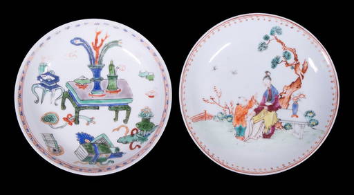
CHINESE KANGXI PERIOD PORCELAIN SAUCERSThomaston Place Auction Galleries4.4(393)See Sold PriceFeb 24, 2024
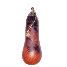
ANTIQUE CHINESE NATURAL GOURD SNUFF BOTTLE SILVERNoble House Collection Gallery4.5(123)See Sold PriceMar 10, 2024
Willem Blaeu, Etc. 17th C. Antiquarian Maps, 2Auctions at Showplace4.6(740)See Sold PriceMar 17, 2024
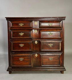
English William and Mary Oak Chest of Drawers, 17th/18thc.Neue Auctions4.6(357)See Sold PriceMar 02, 2024
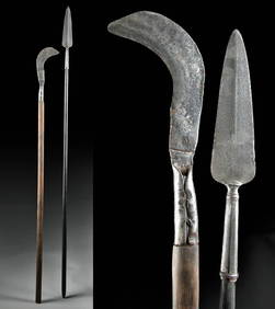
18th C. European Iron Polearms - Spear + BillhookArtemis Fine Arts4.8(1.4k)See Sold PriceFeb 26, 2024
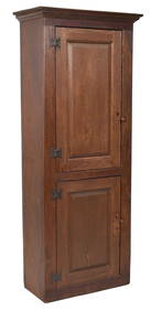
18TH C. NEW ENGLAND RED STAINED CHIMNEY CUPBOARD.William Smith Auctions4.6(147)See Sold PriceMar 06, 2024
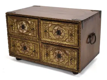
ANTIQUE INDO PORTUGUESE CARVED & GILT TABLE CHEST.William Smith Auctions4.6(147)See Sold PriceMar 06, 2024
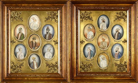
14 ANTIQUE MINIATURE HAND PAINTED MUGHAL PORTRAITS.William Smith Auctions4.6(147)See Sold PriceMar 06, 2024
CHINESE EXPORT BLUE & WHITE PORCELAIN DISHA.H. Wilkens Auctions & Appraisals4.7(396)See Sold PriceFeb 29, 2024