ATLAS of ANTIENT GEOGRAPHY by SAMUEL BUTLER 1843John McInnis Auctioneers,LLC4.6(502)See Sold PriceFeb 24, 2024
18TH C. ANTIQUE MAP: FRENCH & INDIAN WAR, FRAMEDThomaston Place Auction Galleries4.4(386)See Sold PriceFeb 24, 2024
Rand McNally Railroad Map Cabinet w/ 21 Railroad MapsRail & Road Auctions4.6(165)See Sold PriceMar 08, 2024
Keith Haring - Ink on New York Map, Best Buddies, Inscribed, Signed, and DatedSapphire Auction Gallery4(67)See Sold PriceMar 02, 2024
LATE 17TH C. FRENCH MAP OF THE NEW WORLD BY ALEXIS-HUBERT JAILLOT (1632-1712)Thomaston Place Auction Galleries4.4(386)See Sold PriceFeb 24, 2024
Central Railroad of New Jersey Map of Sandy Hook Route-ca. 1903JM Hobby Supply and Railroad Artifact Auctions4.4(126)See Sold PriceFeb 24, 2024
Lot of Six Mixed Atlas Box Cars-HO Scale-New in BoxJM Hobby Supply and Railroad Artifact Auctions4.4(126)See Sold PriceFeb 25, 2024
Rand McNally/Santa Fe Railroad Map of Iowa-1912JM Hobby Supply and Railroad Artifact Auctions4.4(126)See Sold PriceFeb 24, 2024
NICOLAES VISSCHER (NETHERLANDS, 1618-1709) MAP OF THE NEW WORLDThomaston Place Auction Galleries4.4(386)See Sold PriceFeb 24, 2024
17TH C. WORLD MAP BY NICOLAES VISSCHER (NETHERLANDS, 1618-1709)Thomaston Place Auction Galleries4.4(386)See Sold PriceFeb 24, 2024
Lot of Six Mixed Atlas Cabooses-HO Scale-New in BoxJM Hobby Supply and Railroad Artifact Auctions4.4(126)See Sold PriceFeb 25, 2024
1829 Malte-Brun Map of Europe in 1829 -- Europe en 1829Reserve Reduced! Title/Content of Map: 1829 Malte-Brun Map of Europe in 1829 -- Europe en 1829 Date: 1829, Paris Cartographer: M Malte-Brun Size: 8.7 X 11.7 in. An attractive map of Europe showing itsSee Sold Price
1829 Malte-Brun Map of Europe in 1829 -- Europe en 18291829 Malte-Brun Map of Europe in 1829 -- Europe en 1829 1829, Paris M Malte-Brun 8.7 X 11.7 in. An attractive map of Europe showing its political divisions, settlements in the early 19th century alongSee Sold Price
1829 Malte-Brun Map of Europe in 1829 -- Europe en 1829Title: 1829 Malte-Brun Map of Europe in 1829 -- Europe en 1829 Cartographer: M Malte-Brun Year / Place: 1829, Paris Map Dimension (in.): 8.7 X 11.7 in. An attractive map of Europe showing its politicaSee Sold Price
1829 Malte-Brun Map of Europe in 1829 -- Europe en 1829Title/Content of Map: 1829 Malte-Brun Map of Europe in 1829 -- Europe en 1829 Cartographer: M Malte-BrunDate: 1829, Paris Size: 8.7 X 11.7 in. An attractive map of Europe showing its political divisioSee Sold Price
1829 Malte-Brun Map of Europe in 1829 -- Europe en 1829Title/Content of Map: 1829 Malte-Brun Map of Europe in 1829 -- Europe en 1829 Date Printed: 1829, Paris Cartographer: M Malte-Brun Size: 8.7 X 11.7 in. An attractive map of Europe showing its politicaSee Sold Price
1829 Malte-Brun Map of Europe in 1829 -- Europe en 1829Title/Content of Map: 1829 Malte-Brun Map of Europe in 1829 -- Europe en 1829 Cartographer: M Malte-Brun Year/Place: 1829, Paris Size: 8.7 X 11.7 in. An attractive map of Europe showing its politicalSee Sold Price
1829 Malte-Brun Map of Europe in 1829 -- Europe en 1829Reserve Reduced! Title/Content of Map:1829 Malte-Brun Map of Europe in 1829 -- Europe en 1829 Date:1829, Paris Cartographer:M Malte-Brun Size:8.7 X 11.7 in. An attractive map of Europe showing its polSee Sold Price
1829 Malte-Brun Map of Europe in 1829 -- Europe en 1829Title/Content: 1829 Malte-Brun Map of Europe in 1829 -- Europe en 1829 Cartographer: M Malte-Brun Year/Place: 1829, Paris Size: 8.7 X 11.7 in. Description: An attractive map of Europe showing its poliSee Sold Price
1829 Malte-Brun Map of Europe in 1829 -- Europe en 1829Title/Content of Map: 1829 Malte-Brun Map of Europe in 1829 -- Europe en 1829 Date: 1829, Paris Cartographer: M Malte-Brun Size: 8.7 X 11.7 in. An attractive map of Europe showing its political divisiSee Sold Price
1829 Malte-Brun Map of Europe in 1829 -- Europe en 1829Title: 1829 Malte-Brun Map of Europe in 1829 -- Europe en 1829 Cartographer: M Malte-Brun Year / Place: 1829, Paris Map Dimension (in.): 8.7 X 11.7 in. An attractive map of Europe showing its politicaSee Sold Price
1829 Malte-Brun Map of Europe in 1829 -- Europe en 1829Title/Content of Map: 1829 Malte-Brun Map of Europe in 1829 -- Europe en 1829 Cartographer: M Malte-Brun Year/Place: 1829, Paris Size: 8.7 X 11.7 in. An attractive map of Europe showing its politicalSee Sold Price
1829 Malte-Brun Map of Europe in 1829 -- Europe en 1829Title/Content of Map: 1829 Malte-Brun Map of Europe in 1829 -- Europe en 1829 Date: 1829, Paris Cartographer: M Malte-Brun Size: 8.7 X 11.7 in. An attractive map of Europe showing its political divisiSee Sold Price
1829 Malte-Brun Map of Europe in 1829 -- Europe en 1829Title: 1829 Malte-Brun Map of Europe in 1829 -- Europe en 1829 Cartographer: M Malte-Brun Year / Place: 1829, Paris Map Dimension (in.): 8.7 X 11.7 in. An attractive map of Europe showing its politicaSee Sold Price
Malte-Brun Map of Europe in 1829Cartographer: M Malte-Brun Year/Place of Publishing: 1829, Paris 1829 Malte-Brun Map of Europe in 1829 -- Europe en 1829. Attractive map of Europe with political divisions, settlements in the early 19See Sold Price
SoldMalte-Brun: Antique Map of Europe in 1829Title/Content of Map: 1829 Malte-Brun Map of Europe in 1829 -- Europe en 1829 Date Printed: 1829, Paris Cartographer: M Malte-Brun Size: 8.7 X 11.7 in. An attractive map of Europe showing its politicaSee Sold Price
Sold1829 Malte-Brun Map of Germany -- ConfederationReserve Reduced! Title/Content of Map: 1829 Malte-Brun Map of Germany -- Confederation Germanique en 1829 Date: 1829, Paris Cartographer: M Malte-Brun Size: 11.7 x 8.8 in. An attractive map of GermanSee Sold Price
1829 Malte-Brun Map of Germany -- ConfederationTitle/Content of Map: 1829 Malte-Brun Map of Germany -- Confederation Germanique en 1829 Date: 1829, Paris Cartographer: M Malte-Brun Size: 11.7 x 8.8 in. An attractive map of German states, showing iSee Sold Price
1829 Malte-Brun Map of France -- Royaume de France enTitle/Content of Map: 1829 Malte-Brun Map of France -- Royaume de France en 1829 Date: 1829, Paris Cartographer: M Malte-Brun Size: 8.7 X 11.7 in. An attractive map of France showing its political divSee Sold Price
1829 Malte-Brun Map of France -- Royaume de France enTitle/Content of Map: 1829 Malte-Brun Map of France -- Royaume de France en 1829 Date: 1829, Paris Cartographer: M Malte-Brun Size: 8.7 X 11.7 in. An attractive map of France showing its political divSee Sold Price
1829 Malte-Brun Map of France -- Royaume de France enTitle/Content of Map: 1829 Malte-Brun Map of France -- Royaume de France en 1829 Date: 1829, Paris Cartographer: M Malte-Brun Size: 8.7 X 11.7 in. An attractive map of France showing its political divSee Sold Price
1829 Malte-Brun Map of the Netherlands -- Royaume desTitle/Content of Map: 1829 Malte-Brun Map of the Netherlands -- Royaume des Pays-Bas en 1829 Date: 1829, Paris Cartographer: M Malte-Brun Size: 11.7 x 8.8 in. A handsome map of the Netherlands and LuxSee Sold Price
1829 Malte-Brun Map of Germany -- ConfederationTitle/Content of Map: 1829 Malte-Brun Map of Germany -- Confederation Germanique en 1829 Date Printed: 1829, Paris Cartographer: M Malte-Brun Size: 11.7 x 8.8 in. An attractive map of German states, sSee Sold Price
1829 Malte-Brun Map of France -- Royaume de France enTitle/Content of Map: 1829 Malte-Brun Map of France -- Royaume de France en 1829 Date Printed: 1829, Paris Cartographer: M Malte-Brun Size: 8.7 X 11.7 in. An attractive map of France showing its politSee Sold Price
Malte-Brun: Antique Map of the Netherlands, 1829Title/Content of Map: 1829 Malte-Brun Map of the Netherlands -- Royaume des Pays-Bas en 1829 Date Printed: 1829, Paris Cartographer: M Malte-Brun Size: 11.7 x 8.8 in. A handsome map of the NetherlandsSee Sold Price
MAP - Dufour, A. H. ( Malte / Brun ) :MAP - ESPAGNE PARTIE SUD DIVISEE EN PROVINCES ANCIENNES ( MAPLuis Porretta Fine Arts4.3(10)See Sold PriceMar 02, 2024
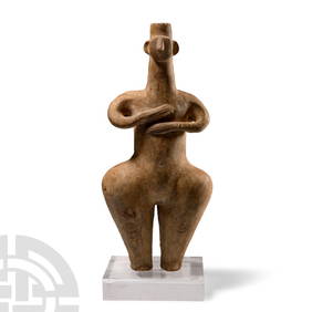
Large Amlash Style Steatopygous Terracotta IdolTimeLine Auctions Ltd.4.5(183)See Sold PriceMar 08, 2024
Emile DECOEUR (1876 - 1953) : Coupe creuse en faïence émaillée de motifs géométriques noirs surValoir Pousse-Cornet4.3(4)See Sold PriceFeb 24, 2024
A "Red Book" of the Greatest War of History 1914North American Artifact Auctions4.6(182)See Sold PriceApr 20, 2024
Two (2) Antique 18th C. Copper Engraved Framed Maps - America & EuropeMagnusson Art Group4.5(46)See Sold PriceMar 14, 2024
Chatelain - Map of the Americas and Details and Insets of Government CounselsTrillium Antique Prints & Rare Books4.5(30)See Sold PriceFeb 24, 2024
Carey, pub. 1796 - A Chart of the West IndiesTrillium Antique Prints & Rare Books4.5(30)See Sold PriceFeb 24, 2024
Carey, pub. 1796 - Map of the State of MarylandTrillium Antique Prints & Rare Books4.5(30)See Sold PriceFeb 24, 2024
Carey, pub. 1796 - Map of GeorgiaTrillium Antique Prints & Rare Books4.5(30)See Sold PriceFeb 24, 2024
Carey, pub. 1796 - Map of The State of South CarolinaTrillium Antique Prints & Rare Books4.5(30)See Sold PriceFeb 24, 2024
Carey, pub. 1796 - Map of KentuckyTrillium Antique Prints & Rare Books4.5(30)See Sold PriceFeb 24, 2024
Carey, pub. 1796 - Map of the Tennassee State formerly part of North Carolina (Tennessee)Trillium Antique Prints & Rare Books4.5(30)See Sold PriceFeb 24, 2024
Van Houtte - Lady's Slipper OrchidTrillium Antique Prints & Rare Books4.5(30)See Sold PriceFeb 24, 2024
1834 Malte-Brun Map of the Caribbean -- West India IslandsJasper524.5(9.8k)See Sold PriceFeb 27, 2024
TRAIN GEORGE FRANCIS: (1829-1904)International Autograph Auctions Europe S.L.4.5(52)See Sold PriceMar 13, 2024
DUCHAMP MARCEL: (1887-1968)International Autograph Auctions Europe S.L.4.5(52)See Sold PriceMar 14, 2024
Waterman, Watermina, Brownish Marble Fountain pen with 18K Gold NibGaia Auctions4.4(65)See Sold PriceMar 04, 2024