ATLAS of ANTIENT GEOGRAPHY by SAMUEL BUTLER 1843John McInnis Auctioneers,LLC4.5(505)See Sold PriceFeb 24, 2024
18TH C. ANTIQUE MAP: FRENCH & INDIAN WAR, FRAMEDThomaston Place Auction Galleries4.4(393)See Sold PriceFeb 24, 2024
Rand McNally Railroad Map Cabinet w/ 21 Railroad MapsRail & Road Auctions4.6(165)See Sold PriceMar 08, 2024
Keith Haring - Ink on New York Map, Best Buddies, Inscribed, Signed, and DatedSapphire Auction Gallery4(67)See Sold PriceMar 02, 2024
LATE 17TH C. FRENCH MAP OF THE NEW WORLD BY ALEXIS-HUBERT JAILLOT (1632-1712)Thomaston Place Auction Galleries4.4(393)See Sold PriceFeb 24, 2024
Central Railroad of New Jersey Map of Sandy Hook Route-ca. 1903JM Hobby Supply and Railroad Artifact Auctions4.4(127)See Sold PriceFeb 24, 2024
Lot of Six Mixed Atlas Box Cars-HO Scale-New in BoxJM Hobby Supply and Railroad Artifact Auctions4.4(127)See Sold PriceFeb 25, 2024
Rand McNally/Santa Fe Railroad Map of Iowa-1912JM Hobby Supply and Railroad Artifact Auctions4.4(127)See Sold PriceFeb 24, 2024
NICOLAES VISSCHER (NETHERLANDS, 1618-1709) MAP OF THE NEW WORLDThomaston Place Auction Galleries4.4(393)See Sold PriceFeb 24, 2024
17TH C. WORLD MAP BY NICOLAES VISSCHER (NETHERLANDS, 1618-1709)Thomaston Place Auction Galleries4.4(393)See Sold PriceFeb 24, 2024
Lot of Six Mixed Atlas Cabooses-HO Scale-New in BoxJM Hobby Supply and Railroad Artifact Auctions4.4(127)See Sold PriceFeb 25, 2024
A new & correct chart of the Channel between England &TITLE/CONTENT OF MAP: 'A new and correct chart of the Channel between England and France with considerable improvements not extant in any draughts hitherto publish'd shewing the sands, shoals, depthsSee Sold Price
A new & correct chart of the Channel between England &TITLE/CONTENT OF MAP: 'A new and correct chart of the Channel between England and France with considerable improvements not extant in any draughts hitherto publish'd shewing the sands, shoals, depthsSee Sold Price
A new & correct chart of the Channel between England &TITLE/CONTENT OF MAP: 'A new and correct chart of the Channel between England and France with considerable improvements not extant in any draughts hitherto publish'd shewing the sands, shoals, depthsSee Sold Price
A new & correct chart of the Channel between England &TITLE/CONTENT OF MAP: 'A new and correct chart of the Channel between England and France with considerable improvements not extant in any draughts hitherto publish'd shewing the sands, shoals, depthsSee Sold Price
A new & correct chart of the Channel between England &TITLE/CONTENT OF MAP: 'A new and correct chart of the Channel between England and France with considerable improvements not extant in any draughts hitherto publish'd shewing the sands, shoals, depthsSee Sold Price
A new & correct chart of the Channel between England &TITLE/CONTENT OF MAP: 'A new and correct chart of the Channel between England and France with considerable improvements not extant in any draughts hitherto publish'd shewing the sands, shoals, depthsSee Sold Price
A new & correct chart of the Channel between England &TITLE/CONTENT OF MAP: 'A new and correct chart of the Channel between England and France with considerable improvements not extant in any draughts hitherto publish'd shewing the sands, shoals, depthsSee Sold Price
A new & correct chart of the Channel between England &TITLE/CONTENT OF MAP: 'A new and correct chart of the Channel between England and France with considerable improvements not extant in any draughts hitherto publish'd shewing the sands, shoals, depthsSee Sold Price
A new & correct chart of the Channel between England &TITLE/CONTENT OF MAP: 'A new and correct chart of the Channel between England and France with considerable improvements not extant in any draughts hitherto publish'd shewing the sands, shoals, depthsSee Sold Price
A new & correct chart of the Channel between England &Reserve Reduced! TITLE/CONTENT OF MAP: 'A new and correct chart of the Channel between England and France with considerable improvements not extant in any draughts hitherto publish'd shewing the sandsSee Sold Price
A new & correct chart of the Channel between England & France. COLLINS 1723 mapTitle: A new & correct chart of the Channel between England & France. COLLINS 1723 map Description: A new and correct chart of the Channel between England and France with considerable improvements notSee Sold Price
A new & correct chart of the Channel between England &TITLE/CONTENT OF MAP: 'A new and correct chart of the Channel between England and France with considerable improvements not extant in any draughts hitherto publish'd shewing the sands, shoals, depthsSee Sold Price
A new & correct chart of the Channel between England & France. COLLINS c1774 mapTitle: A new & correct chart of the Channel between England & France. COLLINS c1774 map Description: A new and correct chart of the Channel between England and France with considerable improvements noSee Sold Price
Collins: Antique Sea Chart Map of English Channel, 1774Title/Content of Map: 'A new and correct chart of the Channel between England and France with considerable improvements not extant in any draughts hitherto publish'd shewing the sands, shoals, depthsSee Sold Price
SoldEnglish Channel.- Mount (Richard) & Thomas Page. A newEnglish Channel.- Mount (Richard) & Thomas Page. A New and Correct Chart of the Channel between England & France with Considerable Improvements, large sea chart of the English Channel, inset maps of PSee Sold Price
Collins: Antique Map of the English Channel, 1774TITLE/CONTENT OF MAP: 'A new and correct chart of the Channel between England and France with considerable improvements not extant in any draughts hitherto publish'd shewing the sands, shoals, depthsSee Sold Price
SoldMount & Page Chart of the English ChannelMount (William) & Thomas Page A New and Correct Chart of the Channel between England & France, large engraved chart of the English Channel, inset maps of Plymouth Sound and the Isle of Wight,See Sold Price
Mount (J.) and T. Page. - A New and Correct Chart ofnorth oriented to the right, England, Scotland and Ireland with inset coats-of-arms, decorative title cartouche upper right, compass roses and rhum lines, engraved map with hand-colouring, 450 x 560mmSee Sold Price
Sold"A New & Correct Chart of all the Known World" by"A New & Correct Chart of all the Known World" by Emanuel Bowen [London 1744]. 46 x 38cmSee Sold Price
SoldEMANUEL BOWEN, MAP PRINT "A NEW & CORRECT CHART"EMANUEL BOWEN, MAP PRINT, H 15", W 18", "A NEW & CORRECT CHART OF ALL THE KNOWN WORLD": Complete title "A New And Correct Chart of all the Known Word Laid down according to Mercator's Projection ExhibSee Sold Price
A new & correct chart of Europe by Thomas Jefferys 1756TITLE/CONTENT OF MAP: 'A new & correct chart of Europe by Thomas Jefferys, Geographer to his Royal Highness the Prince of Wales' The top image on the right hand side shows the entire map. To view a clSee Sold Price
A new & correct chart of Europe by Thomas Jefferys 1756 old antique mapTITLE/CONTENT OF MAP: 'A new & correct chart of Europe by Thomas Jefferys, Geographer to his Royal Highness the Prince of Wales' DATE PRINTED: 1756 IMAGE SIZE: Approx 32.5 x 38.5cm, 12.75 x 15 inchesSee Sold Price
A new & correct chart of Europe by Thomas Jefferys 1756 old antique mapTITLE/CONTENT OF MAP: 'A new & correct chart of Europe by Thomas Jefferys, Geographer to his Royal Highness the Prince of Wales' DATE PRINTED: 1756 IMAGE SIZE: Approx 32.5 x 38.5cm, 12.75 x 15 inchesSee Sold Price
A new & correct chart of Europe by Thomas Jefferys 1756 old antique mapTITLE/CONTENT OF MAP: 'A new & correct chart of Europe by Thomas Jefferys, Geographer to his Royal Highness the Prince of Wales' DATE PRINTED: 1756 IMAGE SIZE: Approx 32.5 x 38.5cm, 12.75 x 15 inchesSee Sold Price
Pr New England Bow Back Windsor SidechairsSchmidt's Antiques Inc. Since 19114.8(431)See Sold PriceMar 02, 2024
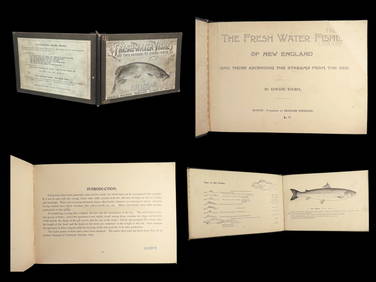
1896 FISHING 1ed Fresh Water Fishes of New England Guide River Sea Bait TackleSchilb Antiquarian Rare Books4.8(428)See Sold PriceMar 10, 2024
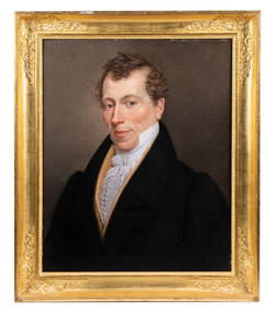
PORTRAIT OF A NEW ENGLAND GENTLEMAN, CA 1810Thomaston Place Auction Galleries4.4(393)See Sold PriceFeb 24, 2024
LATE 18TH C. VERY LARGE CHART OF NORTHEAST CANADA BY DES BARRES (1721-1824), 1780, FRAMEDThomaston Place Auction Galleries4.4(393)See Sold PriceFeb 24, 2024
GROUP OF NEW ENGLAND COUNTRY PRIMITIVE TREENWAREJohn McInnis Auctioneers,LLC4.5(505)See Sold PriceFeb 24, 2024
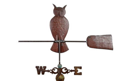
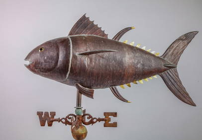
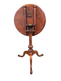
OWL on BROOM by NEW ENGLAND WEATHERVANE SHOPJohn McInnis Auctioneers,LLC4.5(505)See Sold PriceFeb 25, 2024
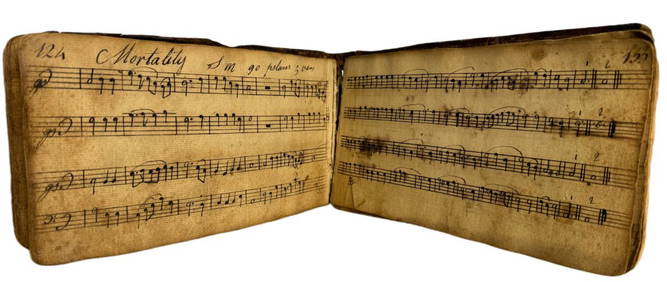
1798 Hand-Written Colonial American Hymnal Leather-Bound Book Signed Abraham Ford New England TownsHess Fine Auctions4.5(210)See Sold PriceMar 02, 2024
18th/19th Century New England Queen Anne tilt top tea table with birdcage, beaded edge top, singleNeely Auction4.6(224)See Sold PriceFeb 25, 2024
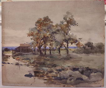
J Francis Murphy W/C New England Landscape PaintingHeritage Gallery Auctions4.4(60)See Sold PriceMar 10, 2024
1946 Guernsey Channel Islands England Reg Cover To New Zealand #N4 Blue PaperMynt Auctions4.6(697)See Sold PriceFeb 26, 2024
GEORGE GUSTAV ADOMEIT (1879-1967) "NEW ENGLAND LANDSCAPE".Amelia Jeffers, Auctioneers & Appraisers4.5(120)See Sold PriceMar 07, 2024
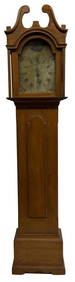
19THC. NEW ENGLAND TALL CASE CLOCK, WORKING ORIGINAL PAINTED DIAL 87" TALL X 19 1/2" WIDE X 11 1/2"Carlsen Gallery, Inc.4.6(164)See Sold PriceMar 03, 2024
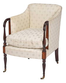
Rare New England Federal Birdseye Maple Inlaid Mahogany BergereBrunk Auctions4.6(470)See Sold PriceMar 08, 2024
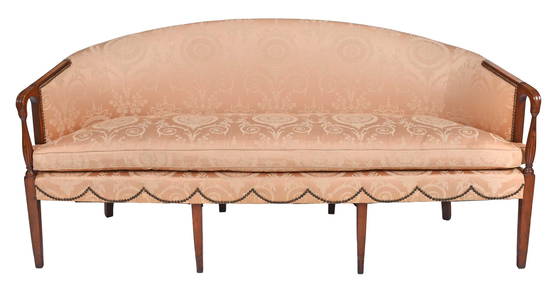
New England Federal Figured Maple Inlaid Mahogany SofaBrunk Auctions4.6(470)See Sold PriceMar 08, 2024
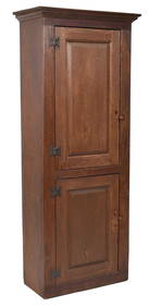
18TH C. NEW ENGLAND RED STAINED CHIMNEY CUPBOARD.William Smith Auctions4.6(147)See Sold PriceMar 06, 2024