SURVEYOR COMPASS / MAGNETIC COMPASS COMPENSATORPridham's Auctions & Appraisals4.7(223)See Sold PriceMar 02, 2024
Awesome Gold/Brass Military Prismatic CompassSouth Florida Auction & Estate Sale Services Inc4.5(522)See Sold PriceMar 08, 2024
Vintage Silver Tone Pocket CompassThe Benefit Shop Foundation Inc.4.3(2.9k)See Sold PriceFeb 28, 2024
Ornate Brass Nautical Screw top Perpetual Calendar CompassSouth Florida Auction & Estate Sale Services Inc4.5(522)See Sold PriceMar 08, 2024
Folky Metal Outdoor Barn "Compass" Wall Hanging 41.5 inches diameterDonny Malone Auctions4.4(1.8k)See Sold PriceMar 04, 2024
Ornate Brass Screw Top Nautical Maritime CompassSouth Florida Auction & Estate Sale Services Inc4.5(522)See Sold PriceMar 08, 2024
Mount (J.) and T. Page. - A New and Correct Chart ofnorth oriented to the right, England, Scotland and Ireland with inset coats-of-arms, decorative title cartouche upper right, compass roses and rhum lines, engraved map with hand-colouring, 450 x 560mmSee Sold Price
SoldMount & Page. Charts of Lowestoft & OrfordnessMount (J.) and T. Page. Publishers. A New and Correct Chart of the Sea Coast from Lowestoft to Orford; A New and Correct Chart of the Sea Coast from Orfordness Lights to Prittlewell,2 coastalSee Sold Price
SoldMount (J.) and T. Page. Publishers. A New and CorMount (J.) and T. Page. Publishers. A New and Correct Chart of the Sea Coast from Lowestoft to Orford; A New and Correct Chart of the Sea Coast from Orfordness Lights to Prittlewell,2 coastalSee Sold Price
W. & J. MOUNT & T. PAGE: 'A NEW CHART OF THE SEA COASTW. & J. MOUNT & T. PAGE: 'A NEW CHART OF THE SEA COAST OF SCOTLAND WITH THE ISLANDS THEREOF..' CIRCA 1756 hand-coloured map on laid paper -- 19 x 21in. (48 x 53.5cm.)See Sold Price
SoldEnglish Channel.- Mount (Richard) & Thomas Page. A newEnglish Channel.- Mount (Richard) & Thomas Page. A New and Correct Chart of the Channel between England & France with Considerable Improvements, large sea chart of the English Channel, inset maps of PSee Sold Price
SoldMount & Page Chart of the English ChannelMount (William) & Thomas Page A New and Correct Chart of the Channel between England & France, large engraved chart of the English Channel, inset maps of Plymouth Sound and the Isle of Wight,See Sold Price
SoldMount & Page Map of the West IndiesMOUNT, William (active 1729-60) & PAGE, Thomas (1704-1762). A New and Correct Chart of the Trading Part of the West Indies.Engraved map with the finest original color in full.London, 1760.20 1/2" x 35See Sold Price
SoldHalley (Capt. Edmund) - A New and Correct Sea Chart ofreduced version of Halley's large 2-sheet map by Mount and Page, advertised in lower left corner, with adjacent inset of the North Pole, title cartouche upper left, engraved chart by John Harris, on 2See Sold Price
SoldMap of West Indies from Mercator 1773"A new general chart for the West Indies of E Wright's projection on Mercator's chart," London: J. Mount & T. Page, ca. 1773. From "The English Pilot. The Fourth Book describing the West India NavigatSee Sold Price
SoldA New and Correct Draught of the Bay of Matanzas.Robert Pearson / Mount & Page, A New and Correct Draught of the Bay of Matanzas. on the North side of ye Island Cuba. done from a Survey in the Year 1729, engraving, after 1729, 12.5 x 9.5 12.5 x 9.5See Sold Price
REV. J LINDSEY A New and Correct Chart of the HarbourREV. J LINDSEY A New and Correct Chart of the Harbour of Cork Engraving, 46 x 54.5cm From 'Great British Coasting Pilot' by Greenville Collins, first published in 1693. The last atlas was published inSee Sold Price
SoldMount (J.) and T. Page. Publishers. A Chart of yeMount (J.) and T. Page. Publishers. A Chart of ye Coast of Barbary from Cape Geer to Cape Bajadore,with A Chart of ye Coast of Barbary from C. Bajadore to the Golfe of St. Anne, two charts onSee Sold Price
Mount (J.) and T. Page. Publishers. A Chart of yeMount (J.) and T. Page. Publishers. A Chart of ye Coast of Barbary from Cape Geer to Cape Bajadore,with A Chart of ye Coast of Barbary from C. Bajadore to the Golfe of St. Anne, two charts onSee Sold Price
SoldMount & Page A Chart of ye Coast of BarbaryMount (J.) and T. Page. Publishers. A Chart of ye Coast of Barbary from Cape Geer to Cape Bajadore,with A Chart of ye Coast of Barbary from C. Bajadore to the Golfe of St. Anne, two charts onSee Sold Price
SoldMount & Page Map of the MediterraneanMOUNT, William (active 1729-60) & PAGE, Thomas (1704-1762). A Correct Chart of the Mediterranean Sea from the Coast of Portugal to the Levant. Engraved Map in two sheets.London: c. 1745.19 1/4" x 47 1See Sold Price
Mount & Page: Antique North Sea Coast Chart, 1771TITLE/CONTENT OF MAP: 'A correct chart of the sea coasts of England, Flanders and Holland. Shewing the sands, shoals, rocks and dangers, the bays, harbours, roads, buoys, beacons & seamarks on the saiSee Sold Price
SoldMAP OF THE CARIBBEAN 18th CenturyMAP OF THE CARIBBEAN 18th Century Titled "A Correct Chart of the Caribee Islands Sold by Mount & Page London". 17.25" x 21.25" sight. Framed 19" x 23".See Sold Price
Thornton, J.: Chart of the Caribe Islands Map 1730Map: A Chart of the Caribe Islands, Puerto Rico/ Lesser Antilles Publishing: Thornton, J., Mount, W.& J., Page, T.: London Date: 1730 Size: 16.75 x 20.75 inches The primary, printed chart used by EnglSee Sold Price
Sold-. Gaudy (John) - A New Chart of the Archipelago,the Aegean and eastern Mediterranean from the Marmara Sea and the Dardanelles to south of Crete, from Mount and Page's English Pilot, with large compass rose and rhum lines, engraved chart with hand-cSee Sold Price
Gaudy (John) - A New Chart of the Archipelago,the Aegean and eastern Mediterranean from the Marmara Sea and the Dardanelles to south of Crete, fro Mount and Page's English Pilot, with large compass rose and rhum lines, engraved chart with hand-coSee Sold Price
1700s Coast of Portugal and Spain Map, Mount & PageEarly 18th century. A partially hand-colored New Sea Chart of the Coast of Portugal and part of Spain, from Cape Finistere. By the notable Mount & Page mao company. Fair condition. Bottom rightSee Sold Price
SoldJ.H.Moore, Chart of the Baltic 1791,J.H.Moore, Chart of the Baltic 1791, A New and Correct Chart of the Baltic from the Cattegat to Soderhamn and the Entrance of the Gulf of Finland, rolling wall map published 1791, uncoloured, 125 x 10See Sold Price
SoldMichelot, Henri et Bremond LaurentMichelot, Henri et Bremond Laurent A new chart of the island of Corsica and Sardinia. In The english pilot… by Mount and page 1736. 40 x 52 cmSee Sold Price
SoldMount (J.) and T. Page. Publishers. A group of 16Mount (J.) and T. Page. Publishers. A group of 16 marine charts,including the North Sea, the Norwegian sea, with charts of the coast of Denmark, Norway, and others, engraved maps, each c. 425See Sold Price
Northern RR of New Hampshire Original Bylaws-1847JM Hobby Supply and Railroad Artifact Auctions4.4(127)See Sold PriceFeb 24, 2024
Elgin Joliet and Eastern RR Dressel Switch LampJM Hobby Supply and Railroad Artifact Auctions4.4(127)See Sold PriceFeb 24, 2024
New York Central RR Wall Mount LampJM Hobby Supply and Railroad Artifact Auctions4.4(127)See Sold PriceFeb 24, 2024
BOTH TITLE PAGES OF COLLINS" COASTAL SURVEY, 1776, IN MATCHING FRAMESThomaston Place Auction Galleries4.4(393)See Sold PriceFeb 24, 2024
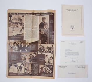
1957 J.F.K. SIGNED LETTER to HELEN KEYESJohn McInnis Auctioneers,LLC4.5(505)See Sold PriceFeb 25, 2024
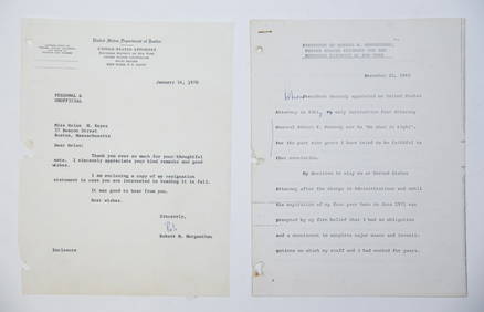
1969 RESIGNATION of ROBERT M. MORGENTHAUJohn McInnis Auctioneers,LLC4.5(505)See Sold PriceFeb 25, 2024
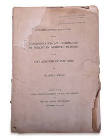
1908 Report on Proposed New York / New Jersey New Railway SystemRail & Road Auctions4.6(165)See Sold PriceMar 08, 2024
[THEATRE]. MITCHELL, Maggie (1832-1918). Po...Potter & Potter Auctions4.6(545)See Sold PriceMar 07, 2024
“Miss Cubas”. Group of Two CDVs of...Potter & Potter Auctions4.6(545)See Sold PriceMar 07, 2024
[NEW YORK STATE]. Scrapbook of photographs of Lake George a...Potter & Potter Auctions4.6(545)See Sold PriceMar 07, 2024
[EARLY PHOTOGRAPHY]. CDV of a young African American woman identified as a servant aboard the USSFreeman's | Hindman4.4(1.6k)See Sold PriceFeb 27, 2024
[ENSLAVEMENT & ABOLITION]. A group of photographs and other items related to abolitionist figuresFreeman's | Hindman4.4(1.6k)See Sold PriceFeb 27, 2024
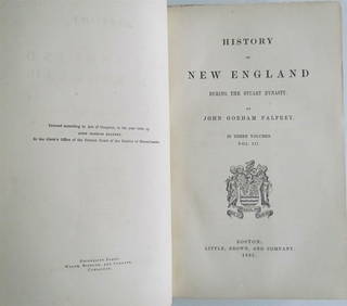
1865 HISTORY OF NEW ENGLAND by J. PALFREY Vol. III antiqueJasper524.5(9.9k)See Sold PriceFeb 27, 2024
1780 BIBLE in DUTCH ILLUSTRATED w/ 38 ENGRAVINGS antique OLD & NEW TESTAMENTJasper524.5(9.9k)See Sold PriceFeb 27, 2024
THE 1780 DUTCH BIBLE ILLUSTRATED WITH 38 ANTIQUE ENGRAVINGS OF THE OLD AND NEW TESTAMENTNY Elizabeth 4.2(86)See Sold PriceMar 03, 2024
America's Heroes & Ronald Reagan The First Four Years HardcoversRapid Estate Liquidators and Auction Gallery4.5(1.1k)See Sold PriceFeb 29, 2024


![[THEATRE]. MITCHELL, Maggie (1832-1918). Po... (1 of 1)](https://p1.liveauctioneers.com/928/318880/171361246_1_x.jpg?height=282&quality=70&version=1707501302)

![[NEW YORK STATE]. Scrapbook of photographs of Lake George a... (1 of 5)](https://p1.liveauctioneers.com/928/318880/171361558_1_x.jpg?height=282&quality=70&version=1707501302)
![[EARLY PHOTOGRAPHY]. CDV of a young African American woman identified as a servant aboard the USS (1 of 2)](https://p1.liveauctioneers.com/197/319238/171467957_1_x.jpg?height=282&quality=70&version=1707520367)
![[ENSLAVEMENT & ABOLITION]. A group of photographs and other items related to abolitionist figures (1 of 3)](https://p1.liveauctioneers.com/197/319238/171468086_1_x.jpg?height=282&quality=70&version=1707520367)