ATLAS of ANTIENT GEOGRAPHY by SAMUEL BUTLER 1843John McInnis Auctioneers,LLC4.6(502)See Sold PriceFeb 24, 2024
18TH C. ANTIQUE MAP: FRENCH & INDIAN WAR, FRAMEDThomaston Place Auction Galleries4.4(386)See Sold PriceFeb 24, 2024
Rand McNally Railroad Map Cabinet w/ 21 Railroad MapsRail & Road Auctions4.6(165)See Sold PriceMar 08, 2024
Keith Haring - Ink on New York Map, Best Buddies, Inscribed, Signed, and DatedSapphire Auction Gallery4(67)See Sold PriceMar 02, 2024
LATE 17TH C. FRENCH MAP OF THE NEW WORLD BY ALEXIS-HUBERT JAILLOT (1632-1712)Thomaston Place Auction Galleries4.4(386)See Sold PriceFeb 24, 2024
Central Railroad of New Jersey Map of Sandy Hook Route-ca. 1903JM Hobby Supply and Railroad Artifact Auctions4.4(126)See Sold PriceFeb 24, 2024
Lot of Six Mixed Atlas Box Cars-HO Scale-New in BoxJM Hobby Supply and Railroad Artifact Auctions4.4(126)See Sold PriceFeb 25, 2024
Rand McNally/Santa Fe Railroad Map of Iowa-1912JM Hobby Supply and Railroad Artifact Auctions4.4(126)See Sold PriceFeb 24, 2024
NICOLAES VISSCHER (NETHERLANDS, 1618-1709) MAP OF THE NEW WORLDThomaston Place Auction Galleries4.4(386)See Sold PriceFeb 24, 2024
17TH C. WORLD MAP BY NICOLAES VISSCHER (NETHERLANDS, 1618-1709)Thomaston Place Auction Galleries4.4(386)See Sold PriceFeb 24, 2024
Lot of Six Mixed Atlas Cabooses-HO Scale-New in BoxJM Hobby Supply and Railroad Artifact Auctions4.4(126)See Sold PriceFeb 25, 2024
SoldWYETH, N.C. Map of Discovery - Western HemisphereWYETH, N.C. "Map of Discovery - Western Hemisphere." Fifth of the series of five mural by N.C. Wyeth, the originals which adorn the walls of the National Geographic Society buildings.Washington: NatioSee Sold Price
SoldN. C. Wyeth, Map of Discovery, Eastern & WesternTwo framed vintage prints / maps after N.C. Wyeth. "Map of Discovery, Eastern & Western Hemisphere". Signed and dated in the prints 1927. The images measure 15.5" x 17.75". Framed and matted under glaSee Sold Price
SoldTwo Rare Maps published in National Geographic by WyethNational Geographic Eastern and Western Hemispheres Maps. NC Wyeth (1822-1945). Chromolithograph. Washington, DC, 1928. Each: 16 3/4 x 18 1/2 inches sheet. In 1927, famed American painter N. C. WyethSee Sold Price
SoldPAIR NC WYETH NAT GEO 1928 MAPSTwo Rare National Geographic Eastern and Western Hemispheres Chromolithographic Maps by NC Wyeth (1822-1945). Washington, DC, 1928. Each: 16 3/4 x 18 1/2 inches sheet. Fold lines visible, as is frequeSee Sold Price
SoldWYETH N.C, MAP OF DISCOVERYWYETH N.C, MAP OF DISCOVERY, Lithography, 1937, 50x45cm - 20x18"See Sold Price
Print of a Map of the Western Hemisphere DiscoveryPrint of the "Map of Discovery", the western hemisphere. Depicts explorer's voyages. 19" W x 17 1/2" H.See Sold Price
SoldAmericas.- Dunn (Samuel) America North and South; withAmericas.- Dunn (Samuel) America North and South; with the Atlantic and Pacific Oceans; wherein are distinguished all the New Discoveries, map of the Western Hemisphere and most of the Pacific, with mSee Sold Price
MAP, Western Hemisphere, ThomsonWestern Hemisphere - America. John Thomson, America, from New General Atlas, 1815 (circa). Hand Color. In Thomson's style, this well engraved map shows the latest discoveries including those of MackenSee Sold Price
SoldPlanisfero del Mondo Nuovo, Descritto…Vincenzo Coronelli (1650 – 1718). Venice, 1691, 20 x 28 inches. Italy’s Greatest 17th Century Map Maker. A very fine map of the Western Hemisphere including the discoveries made by Abel Tasman inSee Sold Price
de l'Isle/Dezauche: Antique Map Western Hemisphere 1782Hemisphere Occidental Dresse pour l'usage particulier du Roi. De l'Isle's important Americas map updated by Dezauche to take into account the discoveries and voyages of Captain Cook. The map shows CooSee Sold Price
SoldThomas Bowen (d.1790), THE WORLD INCLUDING THEThomas Bowen (d.1790)THE WORLD INCLUDING THE DISCOVERIES MADE BY CAPT. COOKhand coloured engraved map of the eastern and western hemispheres with inset of the North Pole, and annotation at 'Oh Why heeSee Sold Price
SoldWeiland (Carl Ferdinand) - Oestlicher Planiglob, Dera pair of large wall maps, showing the Western and Eastern hemispheres, including the discoveries made on Captain Cook's voyages, engraving with outline hand-colouring, each c.1270 x 1270 mm., dissectSee Sold Price
SoldTallis, John (Pub) 1852 Map. Western HemisphereSteel Engraved Map with Original Outline Hand Color Published 1852-56 by John Tallis, London for "The Universal Pronouncing Dictionary" by Thomas Wright. Drawn & Engraved by John Rapkin. Centre fold aSee Sold Price
Sold1829 MAP, WESTERN HEMISPHEREAtlas map of Western Hemisphere marked PAGE 6 in top right corner. An original hand colored antique map, Page 6 from ATLAS OF THE WORLD by James Wyld the Elder (1790-1836), Geographer Royal, who introSee Sold Price
SoldMap Western Hemisphere by Schmidt ca1819 LargeSchmidt, J. M. F. ASIEN ( LARGE MAP OF ASIA FROM SWEDEN AND THE ARCTIC REGIONS TO INDIA, JAPAN, PHILLIPINES, TO PARTS OF AUSTRALIA ) Measures 22" x 26". Drawn by Scmidt, Germany. This wonderful map, pSee Sold Price
SoldMAP, Western Hemisphere, DelisleWestern Hemisphere - America. Delisle/Dezauche, Carte d'Amerique, Dressee pour l'Usage du Roi..., from Atlas Geographique des Quartes Parties du Monde, 1785 (dated). Hand Color. This is a later, updatSee Sold Price
Sold1829 MAP, WESTERN HEMISPHEREAtlas map of Western Hemisphere marked PAGE 6 in top right corner. An original hand colored antique map, Page 6 from ATLAS OF THE WORLD by James Wyld the Elder (1790-1836), Geographer Royal, who introSee Sold Price
SoldMAP, Western Hemisphere, JanvierWestern Hemisphere - America. Janvier/Santini, L'Amerique Divisee en ses Principaux Etats Assujettie aux Observations Astronomiqes, 1784 (circa). Hand Color. This large, handsome map of North and SoutSee Sold Price
MAP, Western Hemisphere, BlaeuWestern Hemisphere - America. Willem Blaeu, Americae Nova Tabula, 1630 (circa). Hand Color. This stunning carte-a-figures map is a superb example of the fine art of decorative cartography and a seventSee Sold Price
SoldMAP, Western Hemisphere, OrteliusPacific Ocean, Western Hemisphere. Abraham Ortelius, Maris Pacifici, (quod Vulgo Mar del Zur), cum Regionibus Circumiacentibus, Insulisque in Eodem Passim Sparsis, Novissima Descriptio, 1589 (dated).See Sold Price
SoldEARLY 18th C. MAP, WESTERN HEMISPHERE, DE FERTitle: Map: L'Amerique Meridionale et Septentrionale, Pub: Nicholas de Fer, Date: (1700) Circa 1705, Medium: HC Engraving, Paper size: 11 3/4 x 17, Inscribed: Publisher identified in the matrix, CondiSee Sold Price
SoldMAP, Western Hemisphere, SeutterWestern Hemisphere - America. Matthias Seutter, Novus Orbis sive America Meridionalis et Septentrionalis, per sua Regna, Provincias et Insulas Iuxta Observationes et Descriptiones Recentiss. Divisa etSee Sold Price
MAP, Western Hemisphere, OrteliusWestern Hemisphere - America. Abraham Ortelius, Americae sive Novi Orbis, Nova Descriptio, 1579 (published). Hand Color. This is one of the most famous maps of America, and one that had enormous influSee Sold Price
MAP - Western Hemisphere. OrteliusWestern Hemisphere - America. Abraham Ortelius, Americae sive Novi Orbis, Nova Descriptio, 1601 (published). Hand Color. This is one of the most famous maps of America and one that had enormous influeSee Sold Price
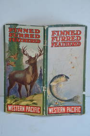
Western Pacific RR Finned Furred Feathered Brochure-1912JM Hobby Supply and Railroad Artifact Auctions4.4(126)See Sold PriceFeb 24, 2024
Great Western RY November 1, 1880 Public TimetableJM Hobby Supply and Railroad Artifact Auctions4.4(126)See Sold PriceFeb 24, 2024
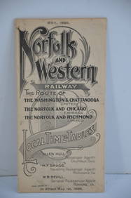
Norfolk and Western RY May 1898 Public TimetableJM Hobby Supply and Railroad Artifact Auctions4.4(126)See Sold PriceFeb 24, 2024
17TH C. WORLD MAP BY NICOLAES VISSCHER (NETHERLANDS, 1618-1709)Thomaston Place Auction Galleries4.4(386)See Sold PriceFeb 24, 2024
19thc Colton Map, Comparitive Size of Lakes & IslandsConnoisseur Auctions4(333)See Sold PriceFeb 24, 2024
Pair of Early Railroad Maps - 1874 Delaware, Lackawanna & Western and 1876 Pennsylvania RailroadRail & Road Auctions4.6(165)See Sold PriceMar 07, 2024
[ARCTIC]. BOWEN, Emanuel. A New & Accurate Map of the North...Potter & Potter Auctions4.6(539)See Sold PriceMar 07, 2024
[WORLD WAR II – OKINAWA]. Okinawa Shima Western Beaches Top...Potter & Potter Auctions4.6(539)See Sold PriceMar 07, 2024
[MAP]. NICHOLLS, Sutton (1668-1729). An Epitome of Sr. Will...Potter & Potter Auctions4.6(539)See Sold PriceMar 07, 2024
Circa 18th Century Carved Wooden Figure of ChristConcept Art Gallery4.7(508)See Sold PriceMar 06, 2024
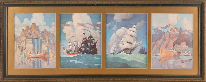
AFTER NEWELL CONVERS (N.C) WYETH (Pennsylvania/Maine/Massachusetts, 1882-1945), Four prints ofEldred's4.7(409)See Sold PriceMar 07, 2024


![[ARCTIC]. BOWEN, Emanuel. A New & Accurate Map of the North... (1 of 1)](https://p1.liveauctioneers.com/928/318880/171360917_1_x.jpg?height=282&quality=70&version=1707501302)
![[WORLD WAR II – OKINAWA]. Okinawa Shima Western Beaches Top... (1 of 1)](https://p1.liveauctioneers.com/928/318880/171361141_1_x.jpg?height=282&quality=70&version=1707501302)
![[MAP]. NICHOLLS, Sutton (1668-1729). An Epitome of Sr. Will... (1 of 1)](https://p1.liveauctioneers.com/928/318880/171361281_1_x.jpg?height=282&quality=70&version=1707501302)