ATLAS of ANTIENT GEOGRAPHY by SAMUEL BUTLER 1843John McInnis Auctioneers,LLC4.6(502)See Sold PriceFeb 24, 2024
18TH C. ANTIQUE MAP: FRENCH & INDIAN WAR, FRAMEDThomaston Place Auction Galleries4.4(386)See Sold PriceFeb 24, 2024
Rand McNally Railroad Map Cabinet w/ 21 Railroad MapsRail & Road Auctions4.6(165)See Sold PriceMar 08, 2024
Keith Haring - Ink on New York Map, Best Buddies, Inscribed, Signed, and DatedSapphire Auction Gallery4(67)See Sold PriceMar 02, 2024
LATE 17TH C. FRENCH MAP OF THE NEW WORLD BY ALEXIS-HUBERT JAILLOT (1632-1712)Thomaston Place Auction Galleries4.4(386)See Sold PriceFeb 24, 2024
Central Railroad of New Jersey Map of Sandy Hook Route-ca. 1903JM Hobby Supply and Railroad Artifact Auctions4.4(126)See Sold PriceFeb 24, 2024
Lot of Six Mixed Atlas Box Cars-HO Scale-New in BoxJM Hobby Supply and Railroad Artifact Auctions4.4(126)See Sold PriceFeb 25, 2024
Rand McNally/Santa Fe Railroad Map of Iowa-1912JM Hobby Supply and Railroad Artifact Auctions4.4(126)See Sold PriceFeb 24, 2024
NICOLAES VISSCHER (NETHERLANDS, 1618-1709) MAP OF THE NEW WORLDThomaston Place Auction Galleries4.4(386)See Sold PriceFeb 24, 2024
17TH C. WORLD MAP BY NICOLAES VISSCHER (NETHERLANDS, 1618-1709)Thomaston Place Auction Galleries4.4(386)See Sold PriceFeb 24, 2024
Lot of Six Mixed Atlas Cabooses-HO Scale-New in BoxJM Hobby Supply and Railroad Artifact Auctions4.4(126)See Sold PriceFeb 25, 2024
The Seven United Provinces with the Land of DrentTITLE/CONTENT OF MAP: 'A map of the Seven United Provinces with the Land of Drent and the Generality Lands' The top image on the right hand side shows the entire map. To view a close up of the map shoSee Sold Price
SoldLot of 4 maps: 1) "Seat of War in the Seven UniteLot of 4 maps: 1) "Seat of War in the Seven United Provinces" comprehending Holland, Zeeland, Utrecht, Gelders, Over-Yssel, Frieseland and Groningen; with the Land of Drent; also Dutch Flanders and DuSee Sold Price
SoldMap of Seven United Provinces, 1836Original engraving by Samuel Walker, 1836. Dimensions: 12” x 16” No Reserve Buyer pays shipping - ships from Ocean View, DESee Sold Price
Sold[Holland] The Seven United Provinces. From the bestTitle: [Holland] The Seven United Provinces. From the best authorities. Publication Date: c1789 Size: 7.3Height - 8.5Width Additional Information: Plate XII. From an unidentified English atlas ReserveSee Sold Price
Sold1783 Folding Map of Seven United ProvincesA New Map of the Seven United Provinces, by J. Bayley, printed at London in 1783, published by Harrison and Co. Folding map measuring 16 x 10". Fine condition. Reserve: $15.00 Shipping: Domestic: FlatSee Sold Price
SoldSeven United Provinces With The Austrian, French &Title: Seven United Provinces With The Austrian, French & Dutch Netherlands. Publication Date: c1763 Cartographer: JEFFERYS, T. Size: 7.1Height - 7.1Width Reserve: $45.00 Shipping: Domestic: Flat-rSee Sold Price
SoldTthe Seven United Provinces, & Netherlands, from TheTitle: Tthe Seven United Provinces, & Netherlands, from The Latest Authorities Publication Date: 1790 Cartographer: CONDER, T. Publisher: C. DILLY Size: 7.25Height - 8.5Width Additional Information: ISee Sold Price
c.1800 American Made Map, The Seven United Provinces,The Seven United Provinces. ( Europe / Netherlands ). Issued c.1800 New York. Engraved for Payne's Geography, Published by J. Low. Very early American produced map of the Netherlands. EngravSee Sold Price
SoldDunn (Samuel) The Seven United ProvincesDunn (Samuel) The Seven United Provinces,showing the Netherlands, the North Sea and part of England and France, engraved map with original outline hand-colouring, 305 x 435mm., small repair toSee Sold Price
1783 Map of the Seven United ProvincesA New Map of the Seven United Provinces, by J. Bayley, printed at London in 1783, published by Harrison and Co. Folding map measuring 16 x 10". Fine condition. Please note that this lot has a confidenSee Sold Price
Seven United Provinces, With Their Roads and DivisionsTitle: Seven United Provinces, With Their Roads and Divisions Publication Date: 1780-03-02 Cartographer: SAYER, ROBERT Publisher: ROBERT SAYER Size: 18.6X22.25 Stained upper margin. Map 13 from SayerSee Sold Price
c.1800 American Made Map, The Seven United Provinces,The Seven United Provinces. ( Europe / Netherlands ). Issued c.1800 New York. Engraved for Payne's Geography, Published by J. Low. Very early American produced map of the Netherlands. Engraved, possibSee Sold Price
c.1800 American Made Map, The Seven United Provinces,The Seven United Provinces. ( Europe / Netherlands ). Issued c.1800 New York. Engraved for Payne's Geography, Published by J. Low. Very early American produced map of the Netherlands. Engraved,See Sold Price
c.1800 American Made Map, The Seven United Provinces,The Seven United Provinces. ( Europe / Netherlands ). Issued c.1800 New York. Engraved for Payne's Geography, Published by J. Low. Very early American produced map of the Netherlands. Engraved,See Sold Price
Map of Seven United Provinces, 1836Original engraving by Samuel Walker, 1836. Dimensions: 12” x 16” No Reserve This item ships from Ocean View, DE.See Sold Price
Seven United Provinces, & Netherlands, from The LatestTitle/Content of Map: Seven United Provinces, & Netherlands, from The Latest Authorities. Date: 1791 Cartographer: CONDER, T. sculpt. Size: 7.3Height - 8.5Width Publisher: R. WILKINSON Illustration maSee Sold Price
Map of Seven United Provinces, 1836Original engraving by Samuel Walker, 1836. Dimensions: 12” x 16”See Sold Price
1800 Payne Map of The Netherlands -- Seven United ProvincesTitle: 1800 Payne Map of The Netherlands -- Seven United Provinces Cartographer: J Payne Year / Place: 1800, New York Map Dimension (in.): 7.1 X 8.1 in. This is a handsome map of the Netherlands. DetaSee Sold Price
c.1800 American Made Map, The Seven United Provinces,The Seven United Provinces. ( Europe / Netherlands ). Issued c.1800 New York. Engraved for Payne's Geography, Published by J. Low. Very early American produced map of the Netherlands. Engraved,See Sold Price
Map of Seven United Provinces, 1836Original engraving by Samuel Walker, 1836. Dimensions: 12” x 16” This item ships from Ocean View, DE.See Sold Price
Seven United Provinces, & Netherlands, from The LatestTitle: Seven United Provinces, & Netherlands, from The Latest Authorities. Cartographer: CONDER, T. sculpt. Publisher: R. WILKINSON Brief Description: Light offsetting. Height X Width: 7.3x 8.5 ReservSee Sold Price
Holland Or the Seven United Provinces, And theTitle: Holland Or the Seven United Provinces, And the Netherlands Date: 1814 Cartographer: LEWIS, SAMUEL Publisher: M. CAREY Size: 16Height - 13.1Width Provenance: Wide margins. Browned. Reserve: $60.See Sold Price
Map of Seven United Provinces, 1836Original engraving by Samuel Walker, 1836. Dimensions: 12” x 16”See Sold Price
1834 Malte-Brun Map of the Netherlands -- The Seven United Provinces with their DependenciesTitle: 1834 Malte-Brun Map of the Netherlands -- The Seven United Provinces with their Dependencies Cartographer: M. Malte-Brun / S. Walker Year / Place: 1834, Boston Map Dimension (in.): 9.3 x 7.5 inSee Sold Price
7 Greeting Postcards for British Soldiers - Holy LandLevy Auction House4.3(11)See Sold PriceFeb 27, 2024
Frank Frazetta Print "Land of Terror" Custom Gallery FramedMynt Auctions4.6(680)See Sold PriceFeb 25, 2024
7PC 1993 GI Joe Battle Corps Backblast MOSC GroupBruneau & Co. Auctioneers4.5(491)See Sold PriceFeb 24, 2024
7PC WOTC Transformers TCG Booster Boxes SealedBruneau & Co. Auctioneers4.5(491)See Sold PriceFeb 24, 2024
Cooke, George 1801 Antique Map. United States of AmericaAlbion Auctions4.6(336)See Sold PriceMar 01, 2024
LAUPEPA SUSUGA MALIETOA: (1841-1898)International Autograph Auctions Europe S.L.4.5(52)See Sold PriceMar 14, 2024
Samuel Gillespie Prout (1822 - 1911) United KingdomCutler Bay Auctions4.5(168)See Sold PriceFeb 29, 2024
Mauritz Frederik Hendrick De Haas (1832 - 1895) New York/ HollandCutler Bay Auctions4.5(168)See Sold PriceFeb 29, 2024
Set of 4 Maps - Netherlands - Seven United Provinces - Germany - Sweden, Denmark, Norway, FinlandProverde Auctions4.3(3)See Sold PriceFeb 28, 2024
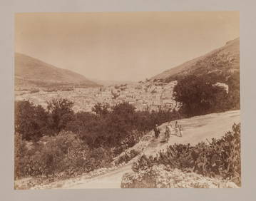
A GROUP OF SEVEN EARLY HOLY LAND BLACK AND WHITE PHOTOS BY FELIX BONFILS. 11” x 8.5”.J. Greenstein & Co., Inc.4.3(55)See Sold PriceApr 16, 2024
Map of the United Provinces of the Netherlands, 1798 PrintAntiques Online Auctions4.6(407)See Sold PriceMar 14, 2024
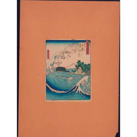
Hiroshige II Woodblock Print, Seven-Mile Beach in SagamiLion and Unicorn4.7(1.8k)See Sold PriceMar 14, 2024
President Andrew Jackson Signed 1830 Land Grant Deed with Official SealDalshire International4.6(2.2k)See Sold PriceFeb 29, 2024


![[Holland] The Seven United Provinces. From the best (1 of 1)](https://p1.liveauctioneers.com/5584/139429/70692708_1_x.jpg?height=282&quality=70&version=1554845662)